Who What Where WhenREMOVE |
Author
[Bridgens, H.F., Fagan, L.]
Full Title
(Penn, Centre, and Bern Townships).
Publisher
H.F. Bridgens
Author
[Bridgens, H.F., Fagan, L.]
Full Title
(Upper Bern Township).
Publisher
H.F. Bridgens
Author
[Bridgens, H.F., Fagan, L.]
Full Title
(Bethel Township).
Publisher
H.F. Bridgens
Author
[Bridgens, H.F., Fagan, L.]
Full Title
(Advertisement) A Useful Directory of Prominent Businesses Houses, &c., in the City of Reading (continued).
Publisher
H.F. Bridgens
Author
Andreas, A. T. (Alfred Theodore), 1839-1900
Full Title
Map of Johnson County, State of Iowa. Chas. Shober & Co., props., Chicago Lith. Co. (Published by the Andreas Atlas Co., Lakeside Building, Chicago, Ills. Engraved & printed by Chas. Shober & Co., Props. of Chicago Lithographing Co.)
Publisher
Andreas Atlas Co.
Author
[Bridgens, H.F., Fagan, L.]
Full Title
(Advertisement) A Useful Directory of Prominent Businesses Houses, &c., in the City of Reading (continued).
Publisher
H.F. Bridgens
Author
[Bridgens, H.F., Fagan, L.]
Full Title
(Advertisement) A Useful Directory of Prominent Businesses Houses, &c., in the City of Reading (continued).
Publisher
H.F. Bridgens
Author
Andreas, A. T. (Alfred Theodore), 1839-1900
Full Title
Plan of Iowa City, Johnson Co. (with) Plan of Marengo, Iowa Co. (with) Plan of Le Claire, Scott Co. Chas. Shober & Co., props., Chicago Lith. Co. (Published by the Andreas Atlas Co., Lakeside Building, Chicago, Ills. Engraved & printed by Chas. Shober & Co., Props. of Chicago Lithographing Co.)
Publisher
Andreas Atlas Co.
Author
H.H. Lloyd & Co.
Full Title
Railroad Map of the United States Prepared Especially for Stewart & Page's Illustrated Historical Atlas by H.H. Lloyd & Co., 21 John St., N.Y.
Publisher
D.J. Stewart
Author
Andreas, A. T. (Alfred Theodore), 1839-1900
Full Title
Map of Buchanan County, State of Iowa. Chas. Shober & Co., props., Chicago Lith. Co. (Published by the Andreas Atlas Co., Lakeside Building, Chicago, Ills. Engraved & printed by Chas. Shober & Co., Props. of Chicago Lithographing Co.)
Publisher
Andreas Atlas Co.
Author
H.H. Lloyd & Co.
Full Title
New Map of Ohio Prepared Especially for Stewart & Page's Illustrated Historical Atlas by H.H. Lloyd & Co., 21 John St., N.Y. Entered ... 1866 ... New York.
Publisher
D.J. Stewart
Author
Andreas, A. T. (Alfred Theodore), 1839-1900
Full Title
Plan of Independence, Buchanan Co. (with) Plan of Jesup, Buchanan Co. (with) Plan of Delhi, co. seat of Delaware Co. (with) Plan of Winthrop, Buchanan Co. (with) Plan of Polk City, Polk Co. (with) Plan of Quasqueton, Buchanan Co. Chas. Shober & Co., props., Chicago Lith. Co. (Published by the Andreas Atlas Co., Lakeside Building, Chicago, Ills. Engraved & printed by Chas. Shober & Co., Props. of Chicago Lithographing Co.)
Publisher
Andreas Atlas Co.
Author
[Stewart, D.J., Brion, A. Forsey]
Full Title
Map of Logan County, Ohio, 1874. Compiled and Drawn by A. Forsey Brion C.E.
Publisher
D.J. Stewart
Author
[Stewart, D.J., Fisk, Wm. M.]
Full Title
Map of the Township of Stokes, Parts of Tps. 6 & 7 & 8. Mapped and drawn by Wm. M. Fisk.
Publisher
D.J. Stewart
Author
Andreas, A. T. (Alfred Theodore), 1839-1900
Full Title
Map of Hamilton County, State of Iowa. Chas. Shober & Co., props., Chicago Lith. Co. (Published by the Andreas Atlas Co., Lakeside Building, Chicago, Ills. Engraved & printed by Chas. Shober & Co., Props. of Chicago Lithographing Co.)
Publisher
Andreas Atlas Co.
Author
[Stewart, D.J., Fisk, Wm. M.]
Full Title
Map of Bloomfield Township, Parts of T.2 & 7S. R.7. & 8.E. Mapped & Drawn by Fisk.
Publisher
D.J. Stewart
Author
[Stewart, D.J., Grosskoff, M.]
Full Title
Map of Miami Township, T. III. R. XIII. Drawn & Compiled by M. Grosskoff. (View) Res. of Jeremiah Spellman. Res. of Henry Hellman. Res. of N.V. Speece, M.D.
Publisher
D.J. Stewart
Author
[Stewart, D.J., Grosskoff, M.]
Full Title
Map of Pleasant Township. Compiled by M. Grosskoff.
Publisher
D.J. Stewart
Author
[Stewart, D.J., Fisk, Wm. M.]
Full Title
Map of Richland Township. Mapped and Compile by Wm. M. Fisk, Adrian, Mich.
Publisher
D.J. Stewart
Author
Andreas, A. T. (Alfred Theodore), 1839-1900
Full Title
Map of Boone County, State of Iowa. Chas. Shober & Co., props., Chicago Lith. Co. (Published by the Andreas Atlas Co., Lakeside Building, Chicago, Ills. Engraved & printed by Chas. Shober & Co., Props. of Chicago Lithographing Co.)
Publisher
Andreas Atlas Co.
Author
[Stewart, D.J., Fisk, Adrian]
Full Title
Map of McArthur Township. Compiled & Mapped by Fisk, Adrian.
Publisher
D.J. Stewart
Author
[Stewart, D.J., Grosskoff, M.]
Full Title
Map of Union Township. Compiled by M. Grosskoff.
Publisher
D.J. Stewart
Author
Stewart, D.J.
Full Title
Map of Harrison Township.
Publisher
D.J. Stewart
Author
Stewart, D.J.
Full Title
Map of Jefferson Township.
Publisher
D.J. Stewart
Author
Stewart, D.J.
Full Title
(View) Res. of Geo. F. Bailey. Res. of Samuel Taylor. Res. of J.E. Heffelfinger. Res. of J.B. Garwood. Res. of Mrs. Maria Tomas. Res. of Dr. B.B. Leonard. (Map) Map of Liberty Township.
Publisher
D.J. Stewart
Author
[Stewart, D.J., Fisk, Wm. M.]
Full Title
Map of Perry Township, Logan County, Ohio. Wm. M. Fisk. (Portraits) Mrs. P. Kautzman. Peter Kautzman. (View) Res. of Peter Kautzman.
Publisher
D.J. Stewart
Author
[Stewart, D.J., Fisk, Wm. M.]
Full Title
Map of Perry Township. Wm. M. Fisk. (Portraits) Mrs. P. Kautzman. Peter Kautzman. (View) Res. of Peter Kautzman.
Publisher
D.J. Stewart
Author
[Stewart, D.J., Waegon, O.E.]
Full Title
Map of Lake Township. Mapped by O.E. Waegon, C.E. (View) Drug Store of Edward S. Clay, E. Bennett & Co., F.S.Case (Peoples Drug Store).
Publisher
D.J. Stewart
Author
Stewart, D.J.
Full Title
Map of Monroe Township.
Publisher
D.J. Stewart
Author
Andreas, A. T. (Alfred Theodore), 1839-1900
Full Title
Map of Guthrie County, State of Iowa. Engraved & printed by Mills & Co., Des Moines, Iowa. (Published by the Andreas Atlas Co., Lakeside Building, Chicago, Ills.)
Publisher
Andreas Atlas Co.
Author
Stewart, D.J.
Full Title
Map of Zane Township.
Publisher
D.J. Stewart
Author
Stewart, D.J.
Full Title
(View) Res. of John Outland. Nutt Bro's Grain Elevator. Res. of A. Halboth. Res. of Wm. Bruce. Res. of Seth McBride. Res. of S.B. Foster.
Publisher
D.J. Stewart
Author
[Stewart, D.J., Fisk]
Full Title
Map of Bokes Creek Township. Mapped and Compiled by Fisk.
Publisher
D.J. Stewart
Author
[Stewart, D.J., Waegon, Oliver F.]
Full Title
Map of Rush Creek Township.
Publisher
D.J. Stewart
Author
Andreas, A. T. (Alfred Theodore), 1839-1900
Full Title
Map of Carroll County, State of Iowa. Engraved & printed by Mills & Co., Des Moines, Iowa. (Published by the Andreas Atlas Co., Lakeside Building, Chicago, Ills.)
Publisher
Andreas Atlas Co.
Author
[Stewart, D.J., Waegon, Oliver F.]
Full Title
Huntsville, Oliver F. Waegon. Richland, Oliver F. Waegon. Zanesfield, Oliver F. Waegon. De Graff, Oliver F. Waegon.
Publisher
D.J. Stewart
Author
[Stewart, D.J., Waegon, C.E.]
Full Title
Map of Bellefontaine, Logan Co. Compiled & Drawn by Oliver F. Waegon, C.E.
Publisher
D.J. Stewart
Author
[Stewart, D.J., Waegon, C.E.]
Full Title
West Liberty. 1874. Oliver F. Waegon C.E.
Publisher
D.J. Stewart
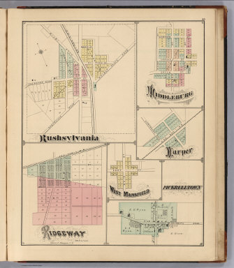
Author
[Stewart, D.J., Waegon, Oliver F.]
Full Title
Rushsylvania. Ridgeway, Oliver F. Waegon C.E., Middleburg, Harper, West Mansfield, Pickelltown.
Publisher
D.J. Stewart
Author
Andreas, A. T. (Alfred Theodore), 1839-1900
Full Title
Map of Webster County, State of Iowa. (Published by the Andreas Atlas Co., Lakeside Building, Chicago, Ills. Engraved & printed by Chas. Shober & Co., Props. of Chicago Lithographing Co.)
Publisher
Andreas Atlas Co.
Author
Stewart, D.J.
Full Title
Last Liberty. Logansville. Northwood. Cherokee. Lewistown. Belle Centre. Greenfield. Quincy.
Publisher
D.J. Stewart
Author
Stewart, D.J.
Full Title
Map of Washington Township. (View) M.E. Church, Built 1873, DeGraff. Mapped and Drawn by Fisk Adrian.
Publisher
D.J. Stewart
Author
Andreas, A. T. (Alfred Theodore), 1839-1900
Full Title
Plan of Fort Dodge, Webster Co., Iowa. (with) Plan of Humboldt, Humboldt Co. (with) Ackley ... Hardin Co. (with) Eldora ... Hardin Co. (Published by the Andreas Atlas Co., Lakeside Building, Chicago, Ills. Engraved & printed by Chas. Shober & Co., Props. of Chicago Lithographing Co.)
Publisher
Andreas Atlas Co.
Author
Andreas, A. T. (Alfred Theodore), 1839-1900
Full Title
Map of Plymouth County. Chas. Shober & Co., props., Chicago Lith. Co. (Published by the Andreas Atlas Co., Lakeside Building, Chicago, Ills. Engraved & printed by Chas. Shober & Co., Props. of Chicago Lithographing Co.)
Publisher
Andreas Atlas Co.
Author
Andreas, A. T. (Alfred Theodore), 1839-1900
Full Title
Counties of Pocahontas, Cherokee, Ida, Buena Vista, Calhoun & Sac. (Published by the Andreas Atlas Co., Lakeside Building, Chicago, Ills. Engraved & printed by Chas. Shober & Co., Props. of Chicago Lithographing Co.)
Publisher
Andreas Atlas Co.
Author
Arrowsmith, Aaron
Full Title
The World. Drawn by A. Arrowsmith, Hydrographer to the Prince Regent. Engraved by Sidney Hall, No. 14 Bury Street, Bloomsby. Edinburgh, Published by Archibald. Constable & Co. 1817.
Publisher
[A. Constable & Co., Longman & Compy]
Author
Arrowsmith, Aaron
Full Title
The World on Mercator's Projection. Drawn by A. Arrowsmith. Engraved by Sidy. Hall. Published, 1817, by A. Constable & Co. Edinburgh.
Publisher
[A. Constable & Co., Longman & Compy]
Author
Arrowsmith, Aaron
Full Title
Europe. Drawn by A. Arrowsmith. Engraved by Sy. Hall, 14 Bury Stt. Bloomsby. Published, 1817, by A. Constable & Co. Edinburgh.
Publisher
[A. Constable & Co., Longman & Compy]
Author
Arrowsmith, Aaron
Full Title
British Islands. Drawn by A. Arrowsmith. Engraved by Sy. Hal,. 14 Bury Stt. Bloomsby. Published, 1817, by A. Constable & Co. Edinburgh.
Publisher
[A. Constable & Co., Longman & Compy]
Author
Arrowsmith, Aaron
Full Title
England. Drawn by A. Arrowsmith. Engraved by S. Hall, 14 Bury Stt. Bloomsby. Published, 1817, by Constable & Co. Edinburgh and Longman & Compy. London.
Publisher
[A. Constable & Co., Longman & Compy]
|