Browse All

1880 Physical Map of Ireland. World Atlas Physical Map of Ireland. W. Swan Sonnens … |

1880 Physical Map of Ireland. World Atlas Physical Map of Ireland. W. Swan Sonnens … |

1845 North America. National Atlas North America. (By Sidney E. Morse and S … |

1845 Canada East. National Atlas Canada East. Entered ... 1845, by Sidney … |

1890 Cover: Arbuckles' Illustrated Atlas of T … World Atlas (Cover to) Arbuckles' Illustrated Atlas … |

1845 Canada West. National Atlas Canada West. Entered ... 1845, by Sidney … |

1890 England. United States. Bolivia. Egypt. World Atlas England. The United States. Bolivia. Egy … |

1845 Nova-Scotia, N.B. &c. National Atlas Nova-Scotia, New Brunswick &c. Entered . … |

1890 France. Central America. Greenland. Swit … World Atlas France. Central America. Greenland. Swit … |

1890 Ecuador. Greece. Portugal. Morocco. World Atlas Ecuador. Greece. Portugal. Morocco. |

1845 Maine. National Atlas Maine. (By Sidney E. Morse and Samuel Br … |

1890 Mexico. Newfoundland. Spain. Sandwich Is … World Atlas Mexico. Newfoundland. Spain. Sandwich Is … |
1890 Belgium. Venezuela. Persia. Italy. World Atlas Belgium. Venezuela. Persia. Italy. |

1845 Vermont, N.H. National Atlas Vermont and New Hampshire. (By Sidney E. … |

1890 German Empire. Paraguay. Cuba. Canada. World Atlas German Empire. Paraguay. Cuba. Dominion … |

1890 Chile. Denmark. Peru. Turkey. World Atlas Chili. Denmark. Peru. Turkey. |

1845 Mass., R.I. National Atlas Massachusetts and Rhode Island. (By Sidn … |

1890 Scotland. Colombia. Austria. Sweden and … World Atlas Scotland. United States of Colombia. Aus … |

1890 Ireland. Japan. Central Africa. India. World Atlas Ireland. Japan. Central Africa. India. |

1845 Connecticut. National Atlas Connecticut. (By Sidney E. Morse and Sam … |

1890 Netherlands. Arabia. China. Afghanistan. World Atlas The Netherlands. Arabia. China. Afghanis … |

1890 Russia. Siberia. Uruguay. Australia. World Atlas Russia. Siberia. Uruguay. Australia. |

1845 New York. National Atlas New York. Entered ... 1842 by Sidney E. … |

1890 Cape Colony (South Africa). Guiana. Arge … World Atlas Cape Colony (South Africa). Guiana. Arge … |

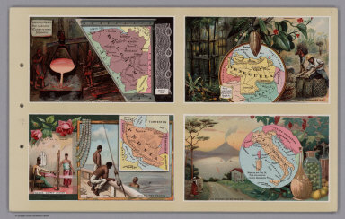
1890 (World Map labeled Arbuckles' Ariosa Cof … World Atlas (World Map labeled Arbuckles' Ariosa Cof … |

1845 New York and vicinity. National Atlas New York and vicinity. Entered ... 1842 … |

1845 City of N.Y. National Atlas City of New York. Entered ... 1842 by Si … |

1887 Section A (northern Staten Island, New Y … County Atlas Section A (northern Staten Island, New Y … |

1887 Section B. (central Staten Island, New Y … County Atlas Section B. (central Staten Island, New Y … |

1887 Section C. (southern Staten Island, New … County Atlas Section C. (southern Staten Island, New … |

1887 Section D. West New Brighton. (Staten Is … County Atlas Section D. West New Brighton. (Staten Is … |

1887 Section E. New Brighton. (Staten Island, … County Atlas Section E. New Brighton. (Staten Island, … |

1845 Pennsylvania. National Atlas Pennsylvania. (with) Philadelphia, Montg … |

1887 Section F. New Brighton. (Staten Island, … County Atlas Section F. New Brighton. (Staten Island, … |

1887 Section G. Stapleton, Village of Edgewat … County Atlas Section G. Stapleton, Village of Edgewat … |

1887 Section H. Clifton, Village of Edgewater … County Atlas Section H. Clifton, Village of Edgewater … |

1887 Section I. Clifton, Village of Edgewater … County Atlas Section I. Clifton, Village of Edgewater … |

1887 Section J. Clifton, Village of Edgewater … County Atlas Section J. Clifton, Village of Edgewater … |

1887 Section K. Tottenville. (Staten Island, … County Atlas Section K. Tottenville. (Staten Island, … |

1887 Section L. Port Richmond, Town of Northf … County Atlas Section L. Port Richmond, Town of Northf … |

1845 New Jersey. National Atlas New Jersey. Entered ... 1841 by T. Gordo … |

1845 Michigan. National Atlas Michigan. Entered ... 1844 by Sidney E. … |

1873 New York. County Atlas Plan of the State of New York. Drawn and … |

1873 New York City and Brooklyn. Long Island. County Atlas Map of the Central Portions of the Citie … |

1845 Iowa, Wisconsin. National Atlas Iowa and Wisconsin. Chiefly from the map … |
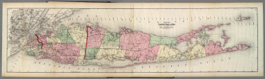
1873 Long Island. County Atlas Map of Long Island. Published by Beers, … |

1873 Flushing and North Side Railroad. Long I … County Atlas The Flushing and North Side Railroad. Ma … |

1873 Equipment and Construction of the (Rail) … County Atlas Equipment and Construction of the (Rail) … |

1873 Brooklyn. Long Island. County Atlas The City of Brooklyn. |

1873 Parkville, Flatbush. Windsor Terrace, Fl … County Atlas Parkville P.O., Tn. of Flatbush. Windsor … |