Who What Where WhenREMOVE |
Author
[Lloyd, H.H., Warner & Beers]
Full Title
Atlas of the United States, Map of Nevada and California. Warner & Beers, Publishers. From H.H. Lloyd & Co.'s Atlas of the United States.
Publisher
Warner & Beers
Author
[Lloyd, H.H., Warner & Beers]
Full Title
Atlas of the United States, Map of the Washington and Oregon. Territory of Alaska. Warner & Beers, Publishers. From H.H. Lloyd & Co.'s Atlas of the United States.
Publisher
Warner & Beers
Author
[Lloyd, H.H., Warner & Beers]
Full Title
Map of the West Indies. Warner & Beers, Publishers. From H.H. Lloyd & Co.'s Atlas of the United States.
Publisher
Warner & Beers
Author
Andreas, A. T. (Alfred Theodore), 1839-1900
Full Title
Map of Franklin County, State of Iowa. Chas. Shober & Co., props., Chicago Lith. Co. (Published by the Andreas Atlas Co., Lakeside Building, Chicago, Ills. Engraved & printed by Chas. Shober & Co., Props. of Chicago Lithographing Co.)
Publisher
Andreas Atlas Co.
Author
[Lloyd, H.H., Warner & Beers]
Full Title
Western Hemisphere. Eastern Hemisphere.
Publisher
Warner & Beers
Author
[Lloyd, H.H., Warner & Beers]
Full Title
Morrison.
Publisher
Warner & Beers
Author
[Lloyd, H.H., Warner & Beers]
Full Title
Mt. Pleasant.
Publisher
Warner & Beers
Author
[Lloyd, H.H., Warner & Beers]
Full Title
Lyndon. (insets) Lyndon. Round Ground.
Publisher
Warner & Beers
Author
[Lloyd, H.H., Warner & Beers]
Full Title
Prophetstown.
Publisher
Warner & Beers
Author
[Lloyd, H.H., Warner & Beers]
Full Title
Newton. (inset) Mineral Springs.
Publisher
Warner & Beers
Author
Andreas, A. T. (Alfred Theodore), 1839-1900
Full Title
Map of Bremer County, State of Iowa. (with) Plan of Waverly, Bremer Co. Chas. Shober & Co., props., Chicago Lith. Co. (Published by the Andreas Atlas Co., Lakeside Building, Chicago, Ills. Engraved & printed by Chas. Shober & Co., Props. of Chicago Lithographing Co.)
Publisher
Andreas Atlas Co.
Author
[Lloyd, H.H., Warner & Beers]
Full Title
Garden Plain. (inset) Unionville.
Publisher
Warner & Beers
Author
[Lloyd, H.H., Warner & Beers]
Full Title
Fulton.
Publisher
Warner & Beers
Author
[Lloyd, H.H., Warner & Beers]
Full Title
Hopkins. (insets) Galt. Empire.
Publisher
Warner & Beers
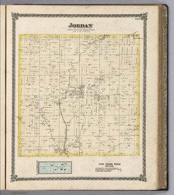
Author
[Lloyd, H.H., Warner & Beers]
Full Title
Jordan. (inset) Sanfordville.
Publisher
Warner & Beers
Author
Andreas, A. T. (Alfred Theodore), 1839-1900
Full Title
Map of Butler County, State of Iowa. Chas. Shober & Co., props., Chicago Lith. Co. (Published by the Andreas Atlas Co., Lakeside Building, Chicago, Ills. Engraved & printed by Chas. Shober & Co., Props. of Chicago Lithographing Co.)
Publisher
Andreas Atlas Co.
Author
Andreas, A. T. (Alfred Theodore), 1839-1900
Full Title
Map of Black Hawk County, State of Iowa. Chas. Shober & Co., props., Chicago Lith. Co. (Published by the Andreas Atlas Co., Lakeside Building, Chicago, Ills. Engraved & printed by Chas. Shober & Co., Props. of Chicago Lithographing Co.)
Publisher
Andreas Atlas Co.
Author
Missouri Publishing Company
Full Title
Rail Road and Township Map of Kansas. 1877. Entered ... 1877 by G.F. Cram ... Washington D.C.
Publisher
Missouri Publishing Company
Author
Missouri Publishing Company
Full Title
Sectional Map of Leavenworth County, Kansas, Showing an outline of the County and its Subdivisions into Congressional and Civil Townships, Locating Towns, Villages, Post Offices, Churches, School Houses, Streams, Railroads, Wagon Roads &c. &c, Published by the Missouri Pub. Co. 1877.
Publisher
Missouri Publishing Company
Author
Missouri Publishing Company
Full Title
(Text Page) Patron's Directory (continued).
Publisher
Missouri Publishing Company
Author
Missouri Publishing Company
Full Title
Map of Township 12 South, Range 22 E. 6th. P.M.. Stranger. Lenape.
Publisher
Missouri Publishing Company
Author
Missouri Publishing Company
Full Title
Map of Township 11 South, Range 22 E. 6th. P.M..
Publisher
Missouri Publishing Company
Author
Missouri Publishing Company
Full Title
Map of Township 10 South, Range 22 E. 6th. P.M.
Publisher
Missouri Publishing Company
Author
Missouri Publishing Company
Full Title
Map of Township 9 & 10 South, Range 23 E. 6th. P.M. Delaware City. Bain City, Proposed Addition to Leavenworth.
Publisher
Missouri Publishing Company
Author
Missouri Publishing Company
Full Title
Map of Township 9 South, Range 22 E. 6th. P.M.
Publisher
Missouri Publishing Company
Author
Missouri Publishing Company
Full Title
Township 8 S, Range 22 & 23 E. 6th. P.M.
Publisher
Missouri Publishing Company
Author
Missouri Publishing Company
Full Title
Tonganoxie. Fall Leaf. Kickapoo. Springdale.
Publisher
Missouri Publishing Company
Author
Missouri Publishing Company
Full Title
Map of Townships 7 and 8 S. Range 21 E. 6th P.M.
Publisher
Missouri Publishing Company
Author
Missouri Publishing Company
Full Title
Map Township 9 South, Range 21 East 6 P.M.
Publisher
Missouri Publishing Company
Author
Missouri Publishing Company
Full Title
Map of Township 10 South, Range 21 E. 6th P.M.
Publisher
Missouri Publishing Company
Author
Missouri Publishing Company
Full Title
Map of Township 11 South, Range 21 E. 6th P.M.
Publisher
Missouri Publishing Company
Author
Missouri Publishing Company
Full Title
Map of Township 12 South, Range 21 E. 6th P.M. Easton.
Publisher
Missouri Publishing Company
Author
Missouri Publishing Company
Full Title
Map of Township 12 South, Range 20 E. 6th P.M. Map of Township 11 South, Range 20th E. 6th P.M.
Publisher
Missouri Publishing Company
Author
Missouri Publishing Company
Full Title
Map of Townships 10 & 9 South, Range 20 E. 6th P.M.
Publisher
Missouri Publishing Company
Author
Missouri Publishing Company
Full Title
Reno. Fair Mount. Summit. Townships 7 & 8 South Range 20 E. 6 P.M.
Publisher
Missouri Publishing Company
Author
[Missouri Publishing Company, Howell, A.C.]
Full Title
Map of Leavenworth City, Compiled from Official Records and Surveys and personal examination by A.C. Howell.
Publisher
Missouri Publishing Company
Author
Andreas, A. T. (Alfred Theodore), 1839-1900
Full Title
Map of Benton County, State of Iowa. Chas. Shober & Co., props., Chicago Lith. Co. (Published by the Andreas Atlas Co., Lakeside Building, Chicago, Ills. Engraved & printed by Chas. Shober & Co., Props. of Chicago Lithographing Co.)
Publisher
Andreas Atlas Co.
Author
Andreas, A. T. (Alfred Theodore), 1839-1900
Full Title
Plan of Vinton, Benton Co. (with) Plan of Blairstown, Benton Co. (with) Plan of Nevada, Story Co. (with) Plan of Belle Plaine, Benton Co. Chas Shober & Co., props., Chicago Lith. Co. (Published by the Andreas Atlas Co., Lakeside Building, Chicago, Ills. Engraved & printed by Chas. Shober & Co., Props. of Chicago Lithographing Co.)
Publisher
Andreas Atlas Co.
Author
McDonough, Leo & Co.
Full Title
Western Hemisphere. Entered ... 1875 by S. Augustus Mitchell ... Washington. Eastern Hemisphere. Entered ... 1875 by S. Augustus Mitchell ... Washington.
Publisher
Leo McDonough & Co.
Author
McDonough, Leo & Co.
Full Title
Map of the United States and Territories.
Publisher
Leo McDonough & Co.
Author
McDonough, Leo & Co.
Full Title
County & Road Map of Kentucky Compiled Expressly for this Work. Published, 1876.
Publisher
Leo McDonough & Co.
Author
Andreas, A. T. (Alfred Theodore), 1839-1900
Full Title
Map of Fayette County, State of Iowa. (Published by the Andreas Atlas Co., Lakeside Building, Chicago, Ills. Engraved & printed by Chas. Shober & Co., Props. of Chicago Lithographing Co.)
Publisher
Andreas Atlas Co.
Author
McDonough, Leo & Co.
Full Title
Map of Daviess County, Ky. Showing precincts, location of towns, post offices, rail roads, wagon roads, churches, school houses, etc., etc. Drawn by E.J. Chamberlain, C.E.
Publisher
Leo McDonough & Co.
Author
McDonough, Leo & Co.
Full Title
Boston Precinct No. 5, (Daviess County, Kentucky). New Boston. Whitesville. Birk City.
Publisher
Leo McDonough & Co.
Author
Andreas, A. T. (Alfred Theodore), 1839-1900
Full Title
Plan of Sioux Rapids, Buena Vista Co. (with) Plan of Onawa ... Monona Co., (with) Plan of Storm Lake, Buena Vista Co. (with) Plan of Newell, Buena Vista Co. (with) Plan of Earlville, Delaware Co. Chas Shober & Co., props., Chicago Lith. Co. (Published by the Andreas Atlas Co., Lakeside Building, Chicago, Ills. Engraved & printed by Chas. Shober & Co., Props. of Chicago Lithographing Co.)
Publisher
Andreas Atlas Co.
Author
McDonough, Leo & Co.
Full Title
Knottsville Precinct No. 4, (Daviess County, Kentucky). Knottsville. Curdsville.
Publisher
Leo McDonough & Co.
Author
McDonough, Leo & Co.
Full Title
Yelvington Precinct No. 3, (Daviess County, Kentucky).
Publisher
Leo McDonough & Co.
Author
McDonough, Leo & Co.
Full Title
Masonville Precinct No. 10, (Daviess County, Kentucky).
Publisher
Leo McDonough & Co.
Author
McDonough, Leo & Co.
Full Title
Murray Precinct No. 6, (Daviess County, Kentucky).
Publisher
Leo McDonough & Co.
|