Who What Where WhenREMOVE |
Author
Radefeld, Carl Christian Franz, 1788-1874
Full Title
Neueste Karte der Kustenlander des Schwarzen Meeres. Entworfen und gezeichnet vom Hauptm. Radefeld. 1845. Stahlstich, Druck u. Verlag des Bibliographischen Instituts in Hildburghausen, Amsterdam, Paris u. Philadelphia, (1860)
Publisher
Bibliographischen Instituts
Author
Page, H.R. & Co.
Full Title
Map of Montana, Published by H.R. Page & Co., Chicago, Ill., 1885. Copyrighted 1882 by H.R. Page & Co.
Publisher
H.R. Page & Co.
Author
Page, H.R. & Co.
Full Title
Map of Nebraska, Published by H.R. Page & Co., Chicago, Ill., 1885. Copyrighted 1879 by H.R. Page.
Publisher
H.R. Page & Co.
Author
Page, H.R. & Co.
Full Title
Page's Map of New Mexico, 1885. Copyrighted 1880 by H.R. Page.
Publisher
H.R. Page & Co.
Author
Grassl, J. (Joseph)
Full Title
Karte des Kaukasischen Isthmus. Entworfen und gezeichnet von J. Grassl, 1856. (with Tiflis und Umgebung). (with Anapa und Umgebung). (with Batum und Umgebung). Stahlstich, Druck und Verlag des Bibliographischen Instituts in Hildburghausen, (1860)
Publisher
Bibliographischen Instituts
Author
Page, H.R. & Co.
Full Title
Map of Texas, Published by H.R. Page & Co., Chicago, Ill., 1885.
Publisher
H.R. Page & Co.
Author
Page, H.R. & Co.
Full Title
Map of Washington Ter., Published by H.R. Page & Co., Chicago, Ills. Copyrighted 1883 by H.R. Page & Co.
Publisher
H.R. Page & Co.
Author
Page, H.R. & Co.
Full Title
Map of Cedar County, Iowa. H.R. Page & Co. Engr., Chicago.(Portraits) H.C. Carr, S.V. Landt, H.C. Piatt, C.E. Wheeler, Hon. W.P. Wolf.
Publisher
H.R. Page & Co.
Author
Page, H.R. & Co.
Full Title
Map of Pioneer, Township 82 North, Range 4 West of 5th Principal Meridian. (View) Cedar County Court House, Tipton, Iowa. Stock Farm of C.W. Carl. Center, Tp. Cedar Co., Iowa.
Publisher
H.R. Page & Co.
Author
Radefeld, Carl Christian Franz, 1788-1874
Full Title
General Karte des Osmanischen Reichs. Nach den bessten Quellen entworf. und gezeichnt. vom Hauptm. Radefeld. 1845. Stich, Druck und Verlag des Bibliographischen Instituts zu Hildburghausen, (1860)
Publisher
Bibliographischen Instituts
Author
Page, H.R. & Co.
Full Title
Map of Fremont, Township 82 North. Range 3 West of 5th Principal Meridian. (View) Res. of Wm. Hill, Center Tp. Cedar Co., Iowa. Res. of R. Hill, Showing Town of Bennett, Sec. 17, Inland Tp., Cedar Co., Iowa. Cottage Grove Stock Farm. Res. of A.G. Downing, Sec.32, Springfield, Tp. Cedar O. Iowa.
Publisher
H.R. Page & Co.
Author
Page, H.R. & Co.
Full Title
Map of Dayton, Township 82 North. Range 2 West of 5th Principal Meridian.
Publisher
H.R. Page & Co.
Author
Page, H.R. & Co.
Full Title
Map of Massillon, Township 82 North. Range 1 West of 5th Principal Meridian.
Publisher
H.R. Page & Co.
Author
Page, H.R. & Co.
Full Title
Map of Linn, Township 81 North. Range 3-4 West of 5th Principal Meridian. Durant, Farmington Township, Cedar County. (View) Res. of Alex Moffitt, Linn Tp. Sec. 6, Cedar County, Iowa. Group of Hereford Cattle, Property of Alex Moffitt, Mechanicsville, Cedar Co. Iowa.
Publisher
H.R. Page & Co.
Author
Page, H.R. & Co.
Full Title
(View) Res. of James Hanna, Sec. 24, Center Tp., Cedar Co., Iowa. M.F. Bunker Prop. (Cattle).
Publisher
H.R. Page & Co.
Author
Page, H.R. & Co.
Full Title
Map of Cass, Township 80-81 North. Range 3-4 West of 5th Principal Meridian.
Publisher
H.R. Page & Co.
Author
Page, H.R. & Co.
Full Title
Red Oak, Township 81 North. Range 2-3 West of 5th Meridian. Centerdale, P.O. and Stanton. Inland, P.O. Plato. (View) Res. of J.T. Newson, Red Oak Tp., Cedar Co., Iowa. Linn Grove Farm Res. of Frank Moffitt, Red Oak Tp., Cedar Co., Iowa.
Publisher
H.R. Page & Co.
Author
Radefeld, Carl Christian Franz, 1788-1874
Full Title
Europaische Turkey, 1845. Entw. u. gez. v. Hauptm. C. Radefeld. Stich, Druck und Verlag des Bibliographischen Instituts in Hildburghausen, (1860)
Publisher
Bibliographischen Instituts
Author
Page, H.R. & Co.
Full Title
Map of Fairfield, Township 81 North, Range 2 West of 5th Principal Meridian. (View) Property of Henry Britcher, Fairfield Tp., Cedar Co., Iowa. Res. of Jacob A. Warner, Fairfield Tp., Cedar Co., Iowa.
Publisher
H.R. Page & Co.
Author
Page, H.R. & Co.
Full Title
Map of Inland, Township 80 North, Range 1 West of 5th Principal Meridian. (View) Res. of W.F. Neely, Center Tp., Cedar County, Iowa. Property of W.F. & R. Neely (Cattle), Rock Creek Stock Farm, Tipton, Cedar Co.,Iowa.
Publisher
H.R. Page & Co.
Author
Page, H.R. & Co.
Full Title
Map of Springfield, Township 81 North, Range 1 West of 5th Principal Meridian.
Publisher
H.R. Page & Co.
Author
Page, H.R. & Co.
Full Title
Map of Center, Township 80 North, Range 2-3 West of 5th Principal Meridian.
Publisher
H.R. Page & Co.
Author
Page, H.R. & Co.
Full Title
Map of Sugar Creek, Township 79 North, 2 West of 5th Principal Meridian. (View) Res. of John Lafrentz, Iowa Tp., Cedar Co., Iowa. Res. of Zadok Ellyson, Sec. 30, Iowa Tp., Cedar Co., Iowa.
Publisher
H.R. Page & Co.
Author
Page, H.R. & Co.
Full Title
Map of Gower, Township 80 North, Range 3-4 West of 5th Principal Meridian.
Publisher
H.R. Page & Co.
Author
Page, H.R. & Co.
Full Title
Map of Springdale, Township 79 North, Range 4 West of 5th Principal Meridian. (View) Res. of H.G. Coe, Clarence, Cedar Co., Iowa. Res. of Henry Hecht, Fairview. Sec. 18, Springfield, TP, Cedar County, Iowa.
Publisher
H.R. Page & Co.
Author
Grassl, J. (Joseph)
Full Title
Neueste Special & Kriegs-Karte der europaischen Turkey in IV Blattern. Entw. u. gez. v. J. Grassl. (H. Schleifmann sc.). II. Section ... (Stich, Druck und Verlag des Bibliographischen Instituts in Hildburghausen, 1860)
Publisher
Bibliographischen Instituts
Author
Page, H.R. & Co.
Full Title
Map of Farmington, Township 79 North. Range 1 West of 5th Principal Meridian.
Publisher
H.R. Page & Co.
Author
Page, H.R. & Co.
Full Title
Map of Rochester, Township 79-80 North. Range 2-3 West of 5th Principal Meridian. Lime City. (Portrait) M.W. Gleason. (View) Clear Creek Stock Farm, Res. of M.W. Gleason, Cedar Co., Iowa. Property of M.W. Gleason, Gleason Co., Iowa.
Publisher
H.R. Page & Co.
Author
Page, H.R. & Co.
Full Title
Downey, Springdale Township, Cedar Co. Massillon, Cedar Co. West Branch, Springdale Township, Cedar Co. (View) Res. of S.R. Lichtenwalter. Res. of W.G.W. Geiger. Cedar County, Iowa.
Publisher
H.R. Page & Co.
Author
Page, H.R. & Co.
Full Title
Map of Iowa, Township 79-80 North. Range 2-3 West of 5th Principal Meridian.
Publisher
H.R. Page & Co.
Author
Page, H.R. & Co.
Full Title
Mechanicsville, Pioneer and Fremont Townships, Cedar Co., Iowa.
Publisher
H.R. Page & Co.
Author
Grassl, J. (Joseph)
Full Title
(Neueste Special & Kriegs-Karte der europaischen Turkey in IV Blattern. Entw. u. gez. v. J. Grassl. H. Schleifmann sc.). I. Section ... (Stich, Druck und Verlag des Bibliographischen Instituts in Hildburghausen, 1860)
Publisher
Bibliographischen Instituts
Author
Page, H.R. & Co.
Full Title
Cedar Bluffs, Cass. Township. Rochester, Rochester Township. Stanwood, Fremont, Township, Cedar Co. Town of Bennett, Inland Township.
Publisher
H.R. Page & Co.
Author
Page, H.R. & Co.
Full Title
Map of Tipton, County Seat of Cedar County, Iowa.
Publisher
H.R. Page & Co.
Author
Page, H.R. & Co.
Full Title
Clarence, Dayton Township, Cedar Co.
Publisher
H.R. Page & Co.
Author
Page, H.R. & Co.
Full Title
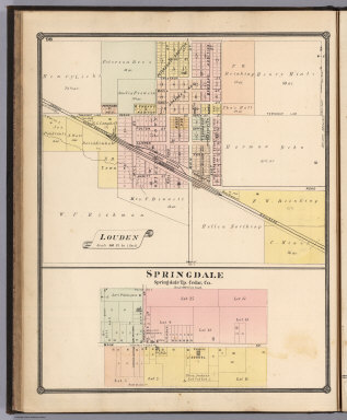
Louden. Springdale, Springdale Tp., Cedar Co.
Publisher
H.R. Page & Co.
Author
Grassl, J. (Joseph)
Full Title
(Neueste Special & Kriegs-Karte der europaischen Turkey in IV Blattern. Entw. u. gez. v. J. Grassl. H. Schleifmann sc.). III. Section ... (Stich, Druck und Verlag des Bibliographischen Instituts in Hildburghausen, 1860)
Publisher
Bibliographischen Instituts
Author
Page, H.R. & Co.
Full Title
Map of the United States. Copyright 1884, by Rand, McNally & Co., Map Publishers, Chicago.
Publisher
H.R. Page & Co.
Author
Page, H.R. & Co.
Full Title
Map of the World.
Publisher
H.R. Page & Co.
Author
Grassl, J. (Joseph)
Full Title
(Neueste Special & Kriegs-Karte der) europaischen Turkey in IV Blattern. Entw. u. gez. v. J. Grassl. H. Schleifmann sc. IV. Section ... (Stich, Druck und Verlag des Bibliographischen Instituts in Hildburghausen, 1860)
Publisher
Bibliographischen Instituts
Author
Radefeld, Carl Christian Franz, 1788-1874
Full Title
Neueste Karte von Asien, 1846. Gezeichnet v. Hauptm. C. Radefeld. Stich, Druck und Verlag des Bibliographischen Instituts in Hildburghausen, (1860)
Publisher
Bibliographischen Instituts
Author
Woodbridge, William C.
Full Title
Map Of The World. Adapted To Woodbridge's Geography. Exhibiting The Eastern & Western Hemisphere, And the Land Hemisphere, Together With Comparative View Of the Rivers And Lake of the Two Continents. Includes 2 insets and Comparative View of Rivers & Lakes on The Eastern and Western Continents. Entered ... 1845, by W.C. Woodbridge ... Massachusetts. Hartford. Published By Wm. Jas. Hamersley. (to accompany) Modern Atlas, Physical, Political And Statistical; Exhibiting On Separate Maps ... Entered ... 1843, by W.C. Woodbridge ... Massachusetts. Hartford. Published By Belknap And Hamersley.
Publisher
Belknap and Hamersley
Author
Woodbridge, William C.
Full Title
Moral And Political Chart Of the Inhabited World. Exhibiting The Prevailing Religions, Forms Of Government And Degrees Of Civilization, And Population Of Each Country. By W.C. Woodbrige. Entered ... 1845, by W.C. Woodbridge ... Massachusetts. Hartford. Published By Wm. Jas. Hamersley. (inset map) Central Europe. (inset untitled map) showing Polynesia and Australia. (to accompany) Modern Atlas, Physical, Political And Statistical; Exhibiting On Separate Maps ... Entered ... 1843, by W.C. Woodbridge ... Massachusetts. Hartford. Published By Belknap And Hamersley.
Publisher
Belknap and Hamersley
Author
Woodbridge, William C.
Full Title
Isothermal Chart Or View Of Climates: Showing also The Situations Of The Principal Plants & Animals Of The World. By W.C. Woodbridge. (to accompany) Modern Atlas, Physical, Political And Statistical; Exhibiting On Separate Maps ... Entered .. . 1843, by W.C. Woodbridge ... Massachusetts. Hartford. Published By Wm. Jas. Hamersley. (inset map) Animals of New Holland.
Publisher
Belknap and Hamersley
Author
Woodbridge, William C.
Full Title
Political Map Of North America. Adapted To Woodbridge's Geography. Entered ... 1843, by W.C. Woodbridge ... Massachusetts. Hartford. Published By Wm. Jas. Hamersley. (to accompany) Modern Atlas, Physical, Political And Statistical; Exhibiting On Separate Maps ...
Publisher
Belknap and Hamersley
Author
Radefeld, Carl Christian Franz, 1788-1874
Full Title
Flusskarte von Asien. Nach den besten Quellen. Entw. u. gez. vom Major Radefeld. 1848. Stich, Druck und Verlag des Bibliographischen Instituts in Hildburghausen, (1860)
Publisher
Bibliographischen Instituts
Author
Woodbridge, William C.
Full Title
Physical Map Of North America. Adapted To Woodbridge's Geography. Entered ... 1843, by W.C. Woodbridge ... Massachusetts. Hartford. Published By Wm. Jas. Hamersley. (to accompany) Modern Atlas, Physical, Political And Statistical; Exhibiting On Separate Maps ...
Publisher
Belknap and Hamersley
Author
Woodbridge, William C.
Full Title
Physical Map Of The United States. Adapted To Woodbridge's Geography. Figures 1. 2, 3, 4., near Rivers Indicated their Rank. Entered ... 1843, by W.C. Woodbridge ... Massachusetts. Hartford. Published By Wm. Jas. Hamersley. (to accompany) Modern Atlas, Physical, Political And Statistical; Exhibiting On Separate Maps ... Includes 4 inset maps.
Publisher
Belknap and Hamersley
Author
Woodbridge, William C.
Full Title
Political Map Of The United States, Mexico And The British Provinces. Adapted To Woodbridge's Geography. Engraved by J.M. Atwood. N. York. Entered ... 1845, by W.C. Woodbridge ... Massachusetts. Hartford. Published By Wm. Jas. Hamersley. (to accompany) Modern Atlas, Physical, Political And Statistical; Exhibiting On Separate Maps ... (inset) Map Of Railways & Canals In The Middle States. (inset map) Michigan, Wisconsin, & Iowa. (inset map) District of Columbia.
Publisher
Belknap and Hamersley
Author
Woodbridge, William C.
Full Title
Physical & Political Map Of The N. Eastern States. Adapted To Woodbridge's Geography. Drawn and Engrd. by Story & Atwood. N. York. Entered ... 1843, by W.C. Woodbridge ... Massachusetts. Hartford. Published By Wm. Jas. Hamersley. (to accompany) Modern Atlas, Physical, Political And Statistical; Exhibiting On Separate Maps ...
Publisher
Belknap and Hamersley
|