Who What Where WhenREMOVE |
Author
Espinosa y Tello, J.
Full Title
Continuacion de los reconocimientos hechos En La Costa No. De America por los Buques de S.M. en varias Campanas desde 1774 a 1792. Cardano Scul. Morata esc. Numero 3.
Publisher
Imprenta Real
Author
[Espinosa y Tello, J., Martinez de Palacios, Geronimo]
Full Title
Carta de los reconocimientos hechos en 1602. Por el Capitan Sebastian Vizcayno Formada por los Planos que hizo el mismo durante su comision. Numo. 4. Cardano lo grabo.
Publisher
Imprenta Real
Author
Espinosa y Tello, J.
Full Title
Plano del Puerto de S. Diego en la Costa Setentl. de Californs. Levantado por el 2o. Piloto de la Armada D. Juan Pantoja. Ano 1782. Numo. 5. Cardano lo grabo. Morata lo escr.
Publisher
Imprenta Real
Author
Espinosa y Tello, J.
Full Title
Plano del Puerto y Bahia De Monte Rey situado en la Costa de Californs. Tabajado a bordo de las Corvetas Descubierta y Atrevida. Ano 1791. Cardano lo grabo. Morata lo escribio. Numo. 6.
Publisher
Imprenta Real
Author
Espinosa y Tello, J.
Full Title
Plano de la Cala De Los Amigos. Situada en la Parte Ocidental de la entrada de Nutka. Ano 1791. Numo. 7. Cardano lo grabo. Morata lo esco.
Publisher
Imprenta Real
Author
Espinosa y Tello, J.
Full Title
Plano Del Puerto De Mulgrave trabajado a bordo de las Corvetas Descubierta y Atrevida de al Marina Real Ano 1791. Numo 8. Cardano lo grabo. Morata esco.
Publisher
Imprenta Real
Author
Espinosa y Tello, J.
Full Title
Plano del Puerto del Desengano Trabajado de Orden del Rey en 1791. Numo 9. J. Cardano ft.
Publisher
Imprenta Real
Author
Carver, Jonathan
Full Title
A New Map of North America, From the Latest Discoveries. 1778. Engrav'd for Carvers Travels.
Publisher
C. Dilly
Author
Carver, Jonathan
Full Title
A Plan of Captain Carvers Travels in the interior Parts of North America in 1766 and 1767.
Publisher
C. Dilly
Author
[James, Edwin, Long, Stephen H.]
Full Title
Country drained by the Mississippi Eastern Section. (with) Country of the Mississippi. (with) Profile or Vertical Section of the Country on the Parallel of Latitude 38 degrees North. Drawn by S.H. Long Maj. T. Engineers. Engrav'd by Young & Delleker. For the Expedition to the Rocky Mountains Vol. I.
Publisher
Carey and Lea
Author
[James, Edwin, Long, Stephen H.]
Full Title
Country drained by the Mississippi Western Section. (with) Profile or Vertical Section of the Country on the Parallel of Latitude 38 degrees North. Drawn by S.H. Long Maj. T. Engineers. Engrav'd by Young & Delleker. For the Expedition to the Rocky Mountains Vol. I.
Publisher
Carey and Lea
Author
[James, Edwin, Long, Stephen H.]
Full Title
Vertical Section on the Parallel of Latitude 41 degrees North intended as a continuation of Maclure's third Section from the sea-shore to the summit of the Alleghenies. (with) Vertical Section on the Parallel of Latitude 35 degrees North intended as a continuation of Maclure's fifth Section. Engrav'd by Young & Delleker.
Publisher
Carey and Lea
Author
[Allen, Paul, Biddle, Nicholas, Clark, William, Lewis, Meriwether]
Full Title
A Map of Lewis and Clark's Track, Across the Western Portion of North America From the Mississippi to the Pacific Ocean; By Order of the Executive of the United States, in 1804, 5 & 6. Copied by Samuel Lewis from the Original Drawing of Wm. Clark. Neele, sculp. 352 Strand, London ... April 28th, 1814 by Longman, Hurst, Rees, Orne & Brown, Paternoster Row.
Publisher
Longman, Hurst, Rees etc.
Author
[Allen, Paul, Biddle, Nicholas, Clark, William, Lewis, Meriwether]
Full Title
Ancient Fortification on the Missouri.
Publisher
Longman, Hurst, Rees etc.
Author
[Allen, Paul, Biddle, Nicholas, Clark, William, Lewis, Meriwether]
Full Title
Great Falls of the Missouri. Neele sc. Strand. Published April 28th, 1814 by Longman & Co. Paternoster Row.
Publisher
Longman, Hurst, Rees etc.
Author
[Allen, Paul, Biddle, Nicholas, Clark, William, Lewis, Meriwether]
Full Title
Great Falls of Columbia River. Neele sc. Strand. Published April 28th, 1814 by Longman & Co. Paternoster Row.
Publisher
Longman, Hurst, Rees etc.
Author
[Allen, Paul, Biddle, Nicholas, Clark, William, Lewis, Meriwether]
Full Title
Lower Falls of the Columbia.
Publisher
Longman, Hurst, Rees etc.
Author
[Allen, Paul, Biddle, Nicholas, Clark, William, Lewis, Meriwether]
Full Title
Mouth of Columbia River. Neele sc. Strand. Published April 28th, 1814 by Longman & Co. Paternoster Row.
Publisher
Longman, Hurst, Rees etc.
Author
Pike, Zebulon Montgomery
Full Title
Falls of St. Anthony.
Publisher
C. & A. Conrad
Author
Pike, Zebulon Montgomery
Full Title
The First Part of Captn. Pike's Chart of the Internal Part of Louisiana. See Plate 2d. & References. Reduced and laid down on a Scale of 40 miles to the Inch. By Anthony Nau.
Publisher
C. & A. Conrad
Author
Pike, Zebulon Montgomery
Full Title
A Chart of the Internal Part of Louisiana, Including all the hitherto unexplored Countries, lying between the River La Platte of the Missouri on the N: and the Red River on the S: the Mississippi East and the Mountains of Mexico West; with a Part of New Mexico & the Province of Texas by Z.M. Pike Captn. U.S.I.
Publisher
C. & A. Conrad
Author
Pike, Zebulon Montgomery
Full Title
A Map of The Internal Provinces of New Spain. The Outlines are from the Sketches of but corrected and improved by Captain Zebulon M. Pike, who was conducted through that Country, in the Year 1807, by Order of the Commandant General of those Provinces.
Publisher
C. & A. Conrad
Author
Pike, Zebulon Montgomery
Full Title
A Sketch of the Vice Royalty Exhibiting the several Provinces and its Aproximation (sic) to the Internal Provinces of New Spain.
Publisher
C. & A. Conrad
Author
Pike, Zebulon Montgomery
Full Title
Map of the Mississippi River from its Source to the Mouth of the Missouri: Laid down from the notes of Lieut. Z.M. Pike by Anthony Nau. Reduced and corrected by the Astronomical Observations of Mr. Thompson at its source; and of Captn. M. Lewis, where it receives the waters of the Missouri. By Nichs. King. Engraved by Francis Shallus, Philadelphia.
Publisher
C. & A. Conrad
Author
Sage, Rufus B.
Full Title
Map of Oregon, California, New Mexico, N.W. Texas & the proposed Territory of Ne-Bras-Ka. By Rufus B. Sage. 1846. F. Michelin's Lith. 111 Nassau St. N.Y.
Publisher
Carey & Hart
Author
Melish, John
Full Title
Map of the United States of America. J. Melish del. H.S. Tanner Sc.
Publisher
Palmer, Thomas & George
Author
Melish, John
Full Title
Chart of the Atlantic Ocean.
Publisher
Palmer, Thomas & George
Author
Melish, John
Full Title
View of the Country round Pittsburg. Drawn by J. Melish. J. Vallance F.S.A. sculpt.
Publisher
Palmer, Thomas & George
Author
Melish, John
Full Title
Falls of Ohio.
Publisher
Palmer, Thomas & George
Author
Melish, John
Full Title
Kentucky. Drawn by J. Melish. J. Vallance sc.
Publisher
Palmer, Thomas & George
Author
Melish, John
Full Title
Ohio. Drawn by J. Melish. J. Vallance sc.
Publisher
Palmer, Thomas & George
Author
Melish, John
Full Title
View of the Country round Zanesville. Drawn by J. Melish. J. Vallance F.S.A. sculpt.
Publisher
Palmer, Thomas & George
Author
Melish, John
Full Title
View of the Country round the Falls of Niagara. Drawn by J. Melish. J. Vallance F.S.A. Sculpt.
Publisher
Palmer, Thomas & George
Author
Gregg, Josiah, 1806-1850
Full Title
A Map of the Indian Territory Northern Texas and New Mexico Showing the Great Western Prairies by Josiah Gregg. Entered ... 1844 by Sidney E. Morse and Samuel Breese ... New York.
Publisher
[Henry G. Langley, Wiley and Putnam.]
Author
Gregg, Josiah, 1806-1850
Full Title
Map of the Interior of Northern Mexico.
Publisher
[Henry G. Langley, Wiley and Putnam.]
Author
[Birkbeck, Morris, Melish, John]
Full Title
United States. Published 1st June 1816 by J. Melish. Philadelphia. Improved to 1818.
Publisher
M. Carey & Son
Author
[Birkbeck, Morris, Melish, John]
Full Title
English Prairie and Adjacent Country. T.V.K & Co. Sc. J. Melish Del.
Publisher
M. Carey & Son
Author
Imlay, Gilbert
Full Title
A Map of The Western Part of the Territories belonging to the United States of America. Drawn from the best Authorities. Engraved for Imlay's Topographical Description of that Country. T. Conder Sculpt. Published June 1st 1795, by J. Debrett, Picadilly, London.
Publisher
J. Debrett
Author
Imlay, Gilbert
Full Title
A Plan of the Rapids of the Ohio. T. Conder, Sculpt. Engraved for Imlay's American Topography. Published Feby. 1st, 1793, by J. Debrett, Piccadilly, London.
Publisher
J. Debrett
Author
Imlay, Gilbert
Full Title
A Map of the State of Kentucky, from Actual Survey by Elihu Barker of Philadelphia. T. Conder Sculpt. London, Published June 1st, 1795 by J. Debrett, PIccadilly.
Publisher
J. Debrett
Author
Imlay, Gilbert
Full Title
A Map of the Tennassee Government, formerly part of North Carolina, taken chiefly from Surveys by Genel. D. Smith & others. T. Conder Sculpt. Engraved for Imlay's American Topography. London, Published June 1st, 1795, by J. Debrett, Piccadilly.
Publisher
J. Debrett
Author
Gallatin, Albert
Full Title
Map of the Indian Tribes of North America about 1600 A.D. along the Atlantic; & about 1800 A.D. westwardly. Published by the Amer: Antiq: Soc: From a drawing by Hon: A. Gallatin.
Publisher
The University Press
Author
[Allen, Paul, Biddle, Nicholas, Clark, William, Lewis, Meriwether]
Full Title
A Map of Lewis and Clark's Track, Across the Western Portion of North America From the Mississippi to the Pacific Ocean; By Order of the Executive of the United States, in 1804, 5 & 6. Copied by Samuel Lewis from the Original Drawing of Wm. Clark. Smal. Harrison fct.
Publisher
Bradford and Inskeep
Author
[Allen, Paul, Biddle, Nicholas, Clark, William, Lewis, Meriwether]
Full Title
Fortification.
Publisher
Bradford and Inskeep
Author
[Allen, Paul, Biddle, Nicholas, Clark, William, Lewis, Meriwether]
Full Title
The Falls and Portage.
Publisher
Bradford and Inskeep
Author
[Allen, Paul, Biddle, Nicholas, Clark, William, Lewis, Meriwether]
Full Title
Great Falls of Columbia River.
Publisher
Bradford and Inskeep
Author
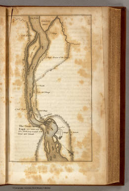
[Allen, Paul, Biddle, Nicholas, Clark, William, Lewis, Meriwether]
Full Title
The Great Shoot or Rapid.
Publisher
Bradford and Inskeep
|