|
Author
International Boundary Commission
Full Title
Boundary between the United States and Mexico by the International Boundary Survey under the Convention of July 29th 1882, Revived February 18th 1889. Engraved by R.F. Bartle & Co., Washington, D.C., U.S.A. No. 15.
Publisher
J. Polhemus.
Author
International Boundary Commission
Full Title
Boundary between the United States and Mexico by the International Boundary Survey under the Convention of July 29th 1882, Revived February 18th 1889. Engraved by R.F. Bartle & Co., Washington, D.C., U.S.A. No. 16.
Publisher
J. Polhemus.
Author
International Boundary Commission
Full Title
Boundary between the United States and Mexico by the International Boundary Survey under the Convention of July 29th 1882, Revived February 18th 1889. Engraved by R.F. Bartle & Co., Washington, D.C., U.S.A. No. 17.
Publisher
J. Polhemus.
Author
International Boundary Commission
Full Title
Boundary between the United States and Mexico by the International Boundary Survey under the Convention of July 29th 1882, Revived February 18th 1889. Engraved by R.F. Bartle & Co., Washington, D.C., U.S.A. No. 18.
Publisher
J. Polhemus.
Author
International Boundary Commission
Full Title
Boundary between the United States and Mexico by the International Boundary Survey under the Convention of July 29th 1882, Revived February 18th 1889. Engraved by R.F. Bartle & Co., Washington, D.C., U.S.A. No. 19.
Publisher
J. Polhemus.
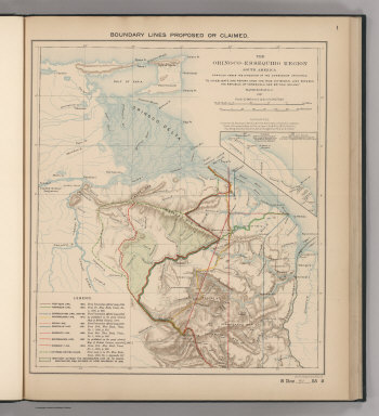
Author
Venezuela-British Guiana Boundary Commission
Full Title
Boundary Lines Proposed or Claimed. 1. S Doc 91 55 2. The Orinoco - Essequibo Region, South America Compiled under the Direction of the Commission Appointed "To Investigate and Report upon the True Divisional Line between the Republic of Venezuela and British Guiana." 1897. Lith. by A. Hoen & Co., Baltimore, MD.
Publisher
United States of America
Author
Venezuela-British Guiana Boundary Commission
Full Title
Forests and Savannas. 2. S Doc 91 55 2. The Orinoco - Essequibo Region, South America, Compiled under the Direction of the Commission Appointed "To Investigate and Report upon the True Divisional Line between the Republic of Venezuela and British Guiana." Washington D.C. 1897. Lith. by A. Hoen & Co., Baltimore, MD.
Publisher
United States of America
Author
Carey, Mathew
Full Title
Missouri Territory formerly Louisiana. Bower, Sc.
Publisher
M. Carey and Son
Author
Gray, Ormando Willis
Full Title
Gray's Historical Maps of the United States by Frank A. Gray. Philadelphia: O.W. Gray & Son. Copyright 1876 by O.W. Gray & Son. United States Showing Acquisition and Transfer of Territory from 1776 to the Present Time. Location of the Principal Battlefields of the Revolutionary War. United States ... 1783. United States ... 1815. United States ... 1850.
Publisher
O.W. Gray & Son
|