Who What Where WhenREMOVEWHAT |
Author
[Wilkes, Charles, United States Exploring Expedition]
Full Title
Harbours in Admiralty Inlet, Oregon Territory by the U.S.Ex.Ex. 1841.
Publisher
C. Sherman
Author
[Wilkes, Charles, United States Exploring Expedition]
Full Title
Apolima, Samoan Group. Harbour of Oafonu (Afono), Isld. of Tutuila, North Side. Harbour of Aur, Isld. of Tutuila, North Side by U.S.Ex.Ex. 1839. Harbour of Fungasar, North Side, Island of Tutuila by the Ex.Ex. 1839.
Publisher
C. Sherman
Author
[Wilkes, Charles, United States Exploring Expedition]
Full Title
Island of Natrai, Feejee (Fiji) Group, by U.S.Ex.Ex. 1840. Island of Angau (Gau or Koro), Feejee (Fiji) Group, by U.S.Ex.Ex. 1840.
Publisher
C. Sherman
Author
[Wilkes, Charles, United States Exploring Expedition]
Full Title
Harbour of Mataatu, Island of Savaii, (Samoa), Harbour of Apia, Island of Upolu. Roadstead between Laulii and Latonca, North Side, Island of Upolu, U.S.Ex.Ex. 1839 &1841. Harbour of Falealili, South Side, Island of Upolu, U.S.Ex.Ex. 1839 &1841.
Publisher
C. Sherman
Author
[Wilkes, Charles, United States Exploring Expedition]
Full Title
Taputeoiea (Tabiteuea) or Drummond's Island, Kingsmill Group, by theU.S.Ex.Ex. 1841. Peacock's Anchorage at Drummond's Island, Kingsmill Group, by the U.S.Ex.Ex. 1841.
Publisher
C. Sherman
Author
[Wilkes, Charles, United States Exploring Expedition]
Full Title
Island of Moala (Keteira), Feejee (Fiji) Group, by the U.S.Ex.Ex. 1840. Island of Totoia (Totoya), Feejee (Fiji) Group, by the U.S.Ex.Ex. 1840. Island of Matuku, Feejee (Fiji) Group, by the U.S.Ex.Ex. 1840.
Publisher
C. Sherman
Author
[Wilkes, Charles, United States Exploring Expedition]
Full Title
Island and Harbours of Mbenga, South Side of Viti Levu, Feejee (Fiji) Group, by the U.S.Ex.Ex. 1840. Rewa-Roads, South Side of Viti Levu, by the U.S.Ex.Ex. 1840.
Publisher
C. Sherman
Author
[Wilkes, Charles, United States Exploring Expedition]
Full Title
Eastern Group, Feejee (Fiji) Islands, by the U.S.Ex.Ex. 1840.
Publisher
C. Sherman
Author
[Wilkes, Charles, United States Exploring Expedition]
Full Title
Western End of Viti Levu, with the Ship Passages and Anchorages from Malolo Passage including the Neighboring Islands to Sakau Bay, Feejee (Fiji) Islands, by the U.S.Ex.Ex. 1840.
Publisher
C. Sherman
Author
[Wilkes, Charles, United States Exploring Expedition]
Full Title
Ports Orchard and Madison including the Inlets and Passages between them in Admiralty Inlet, Oregon Territory, by the U.S.Ex.Ex. 1840.
Publisher
C. Sherman
Author
[Wilkes, Charles, United States Exploring Expedition]
Full Title
Bay of Massefao, Island of Tutuila, by the U.S.Ex.Ex. 1839. Bay of Fagitua, Island of Tutuila, by the U.S.Ex.Ex. 1839. Sketch of Aluau Bay. 1839. Sketch of Anuu Island. 1839.
Publisher
C. Sherman
Author
[Wilkes, Charles, United States Exploring Expedition]
Full Title
Hudson's Island (Nanumanga), by the U.S.Ex.Ex. 1841. Maraki or Matthews Island, Kingsmill Group, by the U.S.Ex.Ex. 1841. Maiana or Hall's Island, Kingsmill Group, by the U.S.Ex.Ex. 1841. Apamama or Hoppers Island, Kingsmill Group, by the U.S.Ex.Ex. 1841. Kuria and Nanouki Islands, Kingsmill Group, by the U.S.Ex.Ex. 1841.
Publisher
C. Sherman
Author
[Wilkes, Charles, United States Exploring Expedition]
Full Title
Island of Yendua, Feejee (Fiji) Group, by the U.S.Ex.Ex. 1840. Nucumurry Harbour, West End of Vanua Levu, by the U.S.Ex.Ex. 1840. Wailea Bay, North Side of Vanua Levu, by the U.S.Ex.Ex. 1840.
Publisher
C. Sherman
Author
[Wilkes, Charles, United States Exploring Expedition]
Full Title
Nanouti Bishop or Sydenhams Island (Nonouti Island), Kingsmill Group, by the U.S.Ex.Ex. 1841. Makin or Pitts Island, Kingsmill Group, by the U.S.Ex.Ex. 1841.
Publisher
C. Sherman
Author
[Wilkes, Charles, United States Exploring Expedition]
Full Title
Raritona Harbour, Island of Ya-Asaua (Yasawa), Asaua Group, by the U.S.Ex.Ex. 1840. Emmons Bay, Island of Ya-Asaua, Asaua Group, by the U.S.Ex.Ex. 1840. Faliki Harbour, East Side of Androna, Asaua Group, by the U.S.Ex.Ex. 1840. Pulotu Harbour, Asaua Group, by the U.S.Ex.Ex. 1840.
Publisher
C. Sherman
Author
[Wilkes, Charles, United States Exploring Expedition]
Full Title
Wahiawa Harbour, South Side of Kauai, Hawaiian Group, by the U.S.Ex.Ex. 1840. Waimea Bay, Southwest Side of Kauai, Hawaiian Gourp, by the U.S.Ex.Ex. 1840. Hulaia Harbour (Nawiliwili Bay), East End of Kauai, Hawaiian Group, by the U.S.Ex.Ex. 1840. Kaneohe Harbour, North Side of Oahu, Hawaiian Group, by the U.S.Ex.Ex. 1840.
Publisher
C. Sherman
Author
[Wilkes, Charles, United States Exploring Expedition]
Full Title
Fangaloa Bay, North Side of Upolu, by the U.S.Ex.Ex. 1839.
Publisher
C. Sherman
Author
[Wilkes, Charles, United States Exploring Expedition]
Full Title
Apia or Charlotte Island, Kingsmill Group, by the U.S.Ex.Ex. 1841. Tarawa or Knox Island, Kingsmill Group, by the U.S.Ex.Ex. 1841.
Publisher
C. Sherman
Author
[Wilkes, Charles, United States Exploring Expedition]
Full Title
Harbour of Ewa or Pearl River, Island of Oahu, Hawaiian Islands, by the U.S.Ex.Ex. 1840. Harbour of Honolulu, Island of Oahu, Hawaiian Islands, by the U.S.Ex.Ex. 1840. South Side of the Island of Oahu, Hawaiian Islands, Shewing the Harbours of Honolulu and Ewa or Pearl River, by the U.S.Ex.Ex. 1840.
Publisher
C. Sherman
Author
[Wilkes, Charles, United States Exploring Expedition]
Full Title
Harbour of Muthuata (Macuata-i-wai), North Side of Vanua Levu, by the U.S.Ex.Ex. 1840. Tibethe & Vicuna Harbour's on the North Side of Vanua Levu, by the U.S.Ex.Ex. 1840.
Publisher
C. Sherman
Author
[Wilkes, Charles, United States Exploring Expedition]
Full Title
Fakaafo (Fakaofo) or Bowditch Island, by the U.S.Ex.Ex. 1841. Nuku-Nono (Nukunonu Atoll) or Duke of Clarence Island, by the U.S.Ex.Ex. 1841. Oatafu or Duke of York Island, by the U.S.Ex.Ex. 1841.
Publisher
C. Sherman
Author
[Wilkes, Charles, United States Exploring Expedition]
Full Title
St. Pablo (Hereheretue Atoll), Paumotu Group, by the U.S.Ex.Ex. 1841. Nukutipipi (Nukutepipi) or Margaret Island, Paumotu Group, by the U.S.Ex.Ex. 1841. Heretua (Anuanuraro) or Archangel of Quiros, Paumotu Group, by the U.S.Ex.Ex. 1841. Teku (Anuanurunga) or Four Crowns of Quiros, Paumotu Group, by the U.S.Ex.Ex. 1841.
Publisher
C. Sherman
Author
[Wilkes, Charles, United States Exploring Expedition]
Full Title
Disappointment Group, by the U.S.Ex.Ex. 1839. Serle (Pukaruha) Island, by the U.S.Ex.Ex. 1839. Clermont-Tonnere (Reao), by the U.S.Ex.Ex. 1839.
Publisher
C. Sherman
Author
[Wilkes, Charles, United States Exploring Expedition]
Full Title
Eastern Group, Sheet 1, Feejee (Fiji) Islands, by the U.S.Ex.Ex. 1840.
Publisher
C. Sherman
Author
[Wilkes, Charles, United States Exploring Expedition]
Full Title
Harbour of Uafatu, Island of Upolu, U.S.Ex.Ex. 1841. Harbour of Saluafata, Island of Upolu, U.S.Ex.Ex. 1841.
Publisher
C. Sherman
Author
[Wilkes, Charles, United States Exploring Expedition]
Full Title
Eastern Group, Sheet 2, Feejee (Fiji) Islands, by the U.S.Ex.Ex. 1840.
Publisher
C. Sherman
Author
[Wilkes, Charles, United States Exploring Expedition]
Full Title
Whippy Harbour, South Side of Viti Levu, by the U.S.Ex.Ex. 1840. Suva Harbour, South Side of Viti Levu, by the U.S.Ex.Ex. 1840. Granby Harbour, South Side of Viti Levu, by the U.S.Ex.Ex. 1840. Ndronga Harbour, South Side of Viti Levu, by the U.S.Ex.Ex. 1840.
Publisher
C. Sherman
Author
[Wilkes, Charles, United States Exploring Expedition]
Full Title
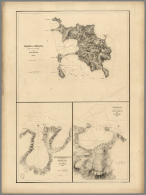
Island of Ovolau (Ovalau), Feejee (Fiji) Group by the U.S.Ex.Ex. 1841. Harbour of Levuka, Island of Ovolau.
Publisher
C. Sherman
Author
[Wilkes, Charles, United States Exploring Expedition]
Full Title
Asaua or Western Group, Feejee (Fiji) Islands, by the U.S.Ex.Ex. 1840.
Publisher
C. Sherman
Author
[Wilkes, Charles, United States Exploring Expedition]
Full Title
Metia (Makatea) Island, Paumotu Group by the U.S.Ex.Ex. 1839. Taweree (Tauere) or St. Simeon or Resolution Island, Paumotu Group, by the U.S.Ex.Ex. 1841. Takurea or Wolconsky Island, Paumotu Group, by the U.S.Ex.Ex. 1841. Seagull Islands, Paumotu Group, by the U.S.Ex.Ex. 1841.
Publisher
C. Sherman
Author
[Wilkes, Charles, United States Exploring Expedition]
Full Title
Kawahe (Kauehi)or Vincennes Island, Paumotu Group by the U.S.Ex.Ex. 1839. Raraka (Rarake) Island, Paumotu Group by the U.S.Ex.Ex. 1839.
Publisher
C. Sherman
Author
[Wilkes, Charles, United States Exploring Expedition]
Full Title
Port Safety, Island of Kea (Kioa), East End of Vanualevu, by the U.S.Ex.Ex. 1839. Fawn Harbour, South Side of Vanua Levu by the U.S.Ex.Ex. 1840. Kombelau Harbour, South Side of Vanua Levu by the U.S.Ex.Ex. 1840. Baino Harbour, South Side of Vanua Levu by the U.S.Ex.Ex. 1840.
Publisher
C. Sherman
Author
[Wilkes, Charles, United States Exploring Expedition]
Full Title
Harbour of Sanaapu (Saanapi, Safatu, Safata), Island of Upolu, U.S.Ex.Ex. 1841. Harbour of Falifa, Island of Upolu, U.S.Ex.Ex. 1841.
Publisher
C. Sherman
Author
[Wilkes, Charles, United States Exploring Expedition]
Full Title
Islands of Manua (Manu'a), Ofoo (Ofu) & Oloosinga (Olosega), Samoan Group, U.S.Ex.Ex. 1839. Island of Tutuila (American Samoa), Samoan Group, U.S.Ex.Ex. 1839.
Publisher
C. Sherman
Author
[Wilkes, Charles, United States Exploring Expedition]
Full Title
Island of Goro (Koro), Feejee (Fiji) Group, U.S.Ex.Ex. 1840. Island of Kantavu (Kadavu), Feejee (Fiji) Group, U.S.Ex.Ex. 1840.
Publisher
C. Sherman
Author
[Wilkes, Charles, United States Exploring Expedition]
Full Title
Swains Island, by the U.S.Ex.Ex. 1841. Jarvis' Island, by the U.S.Ex.Ex. 1840. Birnies Island, Phoenix Group, by the U.S.Ex.Ex. 1841. Enderbury Island, Phoenix Group, by the U.S.Ex.Ex. 1840. Hull's Island (Orona Atoll), Phoenix Group, by the U.S.Ex.Ex. 1841. New York or Washington Island (Teraina Atoll), by the U.S.Ex.Ex. 1840.
Publisher
C. Sherman
Author
[Wilkes, Charles, United States Exploring Expedition]
Full Title
Orange Harbour, Tierra del Fuego, Surveyed by the U.S.Ex.Ex.1839.
Publisher
C. Sherman
Author
[Wilkes, Charles, United States Exploring Expedition]
Full Title
Gardiner's or Kemins Island (Nikumaroro), Phoenix Group, by the U.S.Ex.Ex. 1840. Flint's Island, by the U.S.Ex.Ex. 1841. McKeans Island, Phoenix Group, by the U.S.Ex.Ex. 1840. Maro Reef, by the U.S.Ex.Ex. 1841. Lahaina Roads, Island of Maui (Hawaiian Islands), by the U.S.Ex.Ex. 1841.
Publisher
C. Sherman
Author
[Wilkes, Charles, United States Exploring Expedition]
Full Title
Funafuti or Ellices Island, by the U.S.Ex.Ex. 1841. Nukufetau or Depeysters Island, by the U.S.Ex.Ex. 1841. Ellicus Group, by the U.S.Ex.Ex. 1841..
Publisher
C. Sherman
Author
[Wilkes, Charles, United States Exploring Expedition]
Full Title
Tatara or King's Island, by the U.S.Ex.Ex. 1839. Henuake, Honden, or Dog Id., by the U.S.Ex.Ex. 1839. Penrhyn's Island, by the U.S.Ex.Ex. 1841. Two Groups (Dawhaida I. and Manaka I.), by the U.S.Ex.Ex. 1841.
Publisher
C. Sherman
Author
[Wilkes, Charles, United States Exploring Expedition]
Full Title
Seagull Harbour, Cretton Bay, Wollaston Island, Tierra del Fuego, by the U.S.Ex.Ex. 1839. (Parc Nacional Cabo de Hornos, Chile).
Publisher
C. Sherman
Author
[Wilkes, Charles, United States Exploring Expedition]
Full Title
Ahii (Ahe) and Manhii (Turipaoa) or Peacock and Wilson Islands, by the U.S.Ex.Ex. 1839.
Publisher
C. Sherman
Author
[Wilkes, Charles, United States Exploring Expedition]
Full Title
Map of Hawaiian Group or Sandwich Islands, by the U.S.Ex.Ex. 1841.
Publisher
C. Sherman
Author
[Wilkes, Charles, United States Exploring Expedition]
Full Title
Harbours of Papieti, Toanoa, Papaoa and Matavai Bay with the Ship Channel through Reef, Island of Tahiti, by the U.S.Ex.Ex. 1839.
Publisher
C. Sherman
Author
[Wilkes, Charles, United States Exploring Expedition]
Full Title
Deans, Krusensterns, and Lazareff Islands, by the U.S.Ex.Ex. 1839.
Publisher
C. Sherman
Author
[Wilkes, Charles, United States Exploring Expedition]
Full Title
Colsee-ed Harbour, Hoods Canal, Oregon Territory, by the U.S.Ex.Ex. 1841. Suquamish Harbour, Hoods Canal, Oregon Territory, by the U.S.Ex.Ex. 1841.
Publisher
C. Sherman
Author
[Wilkes, Charles, United States Exploring Expedition]
Full Title
Channel on the North Side of Vanu Levu from Aramula Passage to Muthuata Island, Feejee (Fiji) Islands, by the U.S.Ex.Ex. 1840.
Publisher
C. Sherman
Author
[Wilkes, Charles, United States Exploring Expedition]
Full Title
North Side of Viti Levu with the Ship Passages and Anchorages from Sakau Bay to the Island of Ovolau, Feejee (Fiji) Islands, by the U.S.Ex.Ex. 1840.
Publisher
C. Sherman
Author
[Wilkes, Charles, United States Exploring Expedition]
Full Title
M'Bua or Sandalwood Bay, Island of Vanua Levu, Feejee (Fiji) Group by the U.S.Ex.Ex. 1840.
Publisher
C. Sherman
|