Who What Where WhenREMOVE |
Author
[Wilkes, Charles, United States Exploring Expedition]
Full Title
Samoan or Navigator Islands by the U.S. Ex.Ex., Charles Wilkes Esq. Commander 1839.
Publisher
C. Sherman
Author
[Wilkes, Charles, United States Exploring Expedition]
Full Title
Harbour of Pago Pago, Island of Tutuila by the U.S.Ex.Ex. 1839.
Publisher
C. Sherman
Author
[Wilkes, Charles, United States Exploring Expedition]
Full Title
Port Ludlow, Hoods Canal, Oregon Territory by the U.S.Ex.Ex. 1841. Port Gamble, Hoods Canal, Oregon Territory by the U.S.Ex.Ex. 1841.
Publisher
C. Sherman
Author
[Wilkes, Charles, United States Exploring Expedition]
Full Title
St. Juan Harbour, Straits of Fuca, Vancouver Island by the U.S.Ex.Ex. 1841. Scarborough Harbour, Straits of Fuca, Oregon Territory by the U.S.Ex.Ex. 1841. Port Discovery, Straits of Fuca, Oregon Territory by the U.S.Ex.Ex. 1841.
Publisher
C. Sherman
Author
[Wilkes, Charles, United States Exploring Expedition]
Full Title
Channel of the North Side of Vanua Levu from Muthuata Island to Ivaca Peak, Feejee (Fiji) Islands by the U.S.Ex.Ex. 1840.
Publisher
C. Sherman
Author
[Wilkes, Charles, United States Exploring Expedition]
Full Title
Channel on the South Western Side of Vanua Levu from Ivaca Peak to Savu Savu Bay, Feejee (Fiji) Islands by the U.S.Ex.Ex. 1840.
Publisher
C. Sherman
Author
[Wilkes, Charles, United States Exploring Expedition]
Full Title
Island of Upolu, Samoan Group by the U.S. Ex.Ex. 1839.
Publisher
C. Sherman
Author
[Wilkes, Charles, United States Exploring Expedition]
Full Title
Scabock Harbour, Hoods Canal, Oregon Territory by the U.S.Ex.Ex. 1841. Hooetzen Harbour, Hoods Canal, Oregon Territory by the U.S.Ex.Ex. 1841. Tzu-Sa-Ted Cove, Hoods Canal, Oregon Territory by the U.S.Ex.Ex. 1841.
Publisher
C. Sherman
Author
Norie, J.W.
Full Title
(Tasman Sea and New Zealand) (with) eight inset maps listed in Notes. London ... July 1st 1828, by J.W. Norie & Co. ... Leadenhall Street.
Publisher
J.W. Norie & Co.
Author
Lucas, Fielding Jr.
Full Title
A Chart of the Chesapeake And Delaware Bays Compiled And Published By Fielding Lucas Junr. Baltimore. Corrected_1862. Engraved by John and William W. Warr Philadelphia. Sold by Lucas Brothers. Drawn by F. Lucas Jr. Entered ... 1852 by Fielding Lucas Jr. ... Maryland.
Publisher
Fielding, Lucas Jr.
Author
[Arrowsmith, Aaron, Columbine, Edward Henry]
Full Title
(Chart of Shetland Isles and Orkney Islands). A, Arrowsmith Hydrographer to H.R.H. the Prince of Wales. London. Published June 25th 1807 by A A. Arrowsmith 10 Soho Square. J Palmer Scult. (inset) Island of Unst : A Part of the N.E. Coast of the Shetland Isles. Surveyed in Jany. 1795 by Lieut. Columbine. Scale (ca. 63,360). (title on verso) Scotland N.E. Coast, Shetland Isles ... Firth of Inverness ... Thurso Bay ... Orkney Islands. (0n lower right margin) 1419.
Publisher
A. Arrowsmith
Author
[British Admiralty, Alden, James]
Full Title
N. America West Coast. San Francisco Harbour Surveyed by Lieut. James Alden U.S. Navy 1856. London. Published at the Admiralty 20th. Oct. 1860, under the Superintendence of Captn. Washington, R.N., F.R.S. Hydrographer. Corrections to Augt. 63 ... Engraved by J. & C. Walker. (with 4 profile views). (on lower right margin) 591.
Publisher
British Admiralty
Author
British Admiralty
Full Title
America East Coast: Charleston Harbour, from the United States Coast Survey 1866. The notations in fine line are from U.S. Governt. Report of 1882. Engraved by J. & C. Walker. London. Published at the Admiralty April 1st. 1869 under the Superintendence of Captn. G.H. Richards, R.N., F.R.S. Hydrographer. Corrections and additions to Nov. 1881. (on lower margin) I 83 XII.84. 2806. (inset profile view) City of Charleston.
Publisher
British Admiralty
Author
Imray, James.
Full Title
Chart of the North Pacific Ocean, Exhibiting the Eastern Shores of Asia and the Western Coast of North America from the Equator to Behring's Strait with Plans, on an Enlarged Scale, of the Principal Islands and Harbours. Compiled from the most Recent Surveys made by order of the British, French, and United States Governments. London. Published by James Imray. Chart and Nautical Bookseller, 102 Minores, 1849. (insets) Sandwich Islands (Hawaii); Philippine Islands; Harbor of San Francisco; Victoria Harbor; Mouth of the Columbia River; Marian or Ladrone Islands; Awatska Harbor in Kamchatka.
Publisher
James Imray
Author
Goos, Pieter
Full Title
Paskaerte van Nova Granada, en t'Eylandt California. t'Amersterdam by Pieter Goos op't Waater inde Vergulde Zeepiegel, Ao 1666.
Publisher
Pieter Goos
Author
Norie, J.W.
Full Title
A New Chart of the Windward Passages Containing the Islands of Jamaica, St. Domingo, with Part of Cuba, &c. Drawn from the latest English, Spanish & French Surveys, by J.W. Norie, Hydrogr. 1836. A New Edition. Corrected to 1846.
Publisher
J.W. Norie & Co.
Author
[Ringgold, Cadwalader, 1802-1867, Stuart, F. D. (Fred. D.)]
Full Title
Chart of the Bay of San Pablo Straits Of Carquines and part of the Bay of San Francisco California By Cadwalader Ringgold Commander, U.S. Navy. Assisted by Simon F. Blunt, Lieut. U.S.N. 1850. Projected, Constructed & Drawn by Fred. D. Stuart, Hydrographer, late of the U.S. Ex.Ex. Assisted by A.H. Campbell, Civil Engineer. Entered ... 1851, by Cadwalader Ringgold ... District of Columbia. C.B. Graham, Lithr. Washington, D.C.
Publisher
Jno. T. Towers
Author
[Norie, J.W., Hobbs, J.S., Wilson, Charles]
Full Title
A General Chart of the Indian and Part of the Pacific Oceans, Shewing the Various Passages to & from China, Australia, New Zealand, &c. Carefully Constructed & Compiled from the most approved Observations and Modern Surveys, by J.S. Hobbs, F.R.G.S. Hydrographer. London, Published as the Act directs, March 1st 1850 by Charles Wilson, Late J.W. Norie & Wilson, at the Navigation Warehouse and Naval Academy, No. 157 Leadenhall Street. Additions 1870.
Publisher
Charles Wilson
Author
[Ringgold, Cadwalader, 1802-1867, Stuart, F. D. (Fred. D.)]
Full Title
General chart embracing surveys of the Farallones, entrance to the Bay of San Francisco, bays of San Francisco and San Pablo, Straits of Carquines and Suisun Bay and the Sacramento and San Joaquin rivers to the cities of Sacramento and San Joaquin, California by Cadwalader Ringgold, Commander, U.S. Navy. 1850. Constructed, projected and drawn by Fred. D. Stuart, hydrographer, late of the U.S. Ex. Ex., assisted by Chas. Everett, Jr., draughtsman. Entered ... 1851, by Cadwalader Ringgold ... District of Columbia.
Publisher
Jno. T. Towers
Author
[Blunt, Simon F., Ringgold, Cadwalader, 1802-1867, Stuart, F. D. (Fred. D.)]
Full Title
Chart of the Farallones and entrance to the Bay of San Francisco, California by Cadwalader Ringgold, Commander, U.S. Navy. Assisted by Simon F. Blunt, Lieut. U.S. Navy, 1850. Constructed, projected and drawn by Fred. D. Stuart, hydrographer, late of the U.S. Ex. Ex. C.B. Graham, Lithr., Washington, D.C. Entered ... 1851, by Cadwalader Ringgold ... District of Columbia.
Publisher
Jno. T. Towers
Author
[Humphreys, William P. (William Penn), Knox, Samuel R., Ringgold, Cadwalader, 1802-1867]
Full Title
Chart of Suisun & Vallejo bays with the confluence of the rivers Sacramento and San Joaquin, California by Cadwalader Ringgold, Commander, U.S. Navy. Assisted by Sam R. Knox, Lieut. U.S.N. and Wm. P. Humphreys & J.H. Rowe, engineers, 1850. Constructed, projected and drawn by Fred. D. Stuart, hydrographer, late of the U.S. Ex. Ex., assisted by John Tyssowski, draughtsman. C.B. Graham, Lithr., Washington, D.C. Entered ... 1851, by Cadwalader Ringgold ... District of Columbia.
Publisher
Jno. T. Towers
Author
[Cullberg, Edwin, Emmet, T. A., Ringgold, Cadwalader, 1802-1867, Stuart, F. D. (Fred. D.)]
Full Title
Chart of the Sacramento River from Suisun City to the American River, California by Cadwalader Ringgold, Commander, U.S. Navy. Assisted by Edwin Cullberg, Lieut. of the Hydrotechnic Corps, Swedish Navy and T.A. Emmet, civil engineer, 1850. Projected, constructed & drawn by Fred. D. Stuart, hydrographer, late of the U.S. Ex. Ex., assisted by A.H. Campbell, civil engineer. C.B. Graham, Lithr., Washington, D.C. Entered ... 1851, by Cadwalader Ringgold ... District of Columbia.
Publisher
Jno. T. Towers
Author
Ringgold, Cadwalader, 1802-1867
Full Title
Straits of Carquines and Vallejo Bay by Cadwalader Ringgold, U.S.N., 1850. Anchorage off Sacramento City ... (with) Depot of the Pacific Mail Steam Company, Benicia. (with) Vallejo and Mare Island Strait from the U.S. Coast Survey ... (with) Anchorage off San Francisco ... (with) Anchorage off New York of the Pacific ... C.B. Graham, Lithr., Washington, D.C. Entered ... 1851, by Cadwalader Ringgold ... District of Columbia.
Publisher
Jno. T. Towers
Author
[United States Coast Survey, Rodgers, A.F.]
Full Title
U.S. Coast Survey A.D. Bache, Superintendent. City Of San Francisco And Its Vicinity California. From a plane label survey by A.F. Rogers Sub-assistant. Verified W.R. Palmer Capt. Topl. Engrs. Asst. C.S. In charge of Office. Lith. of J. Bien 60 Fulton St. N.Y.
Publisher
U.S. Coast Survey
Author
United States Coast Survey
Full Title
San Francisco entrance, California : 1884. Issued Aug. 1884, J.E. Hilgard, Superintendent, Verified: C.O. Boutelle, Assiatant in charge of office. Price 50 cents. Redd. Drng. by A. Lindenkohl, C. Junken, E. Molkow and E.J. Sommer. Engd. by J. Enthoffer, E. A. Maedel, J.J. Young, W. Thompson, H.M. Knight, A. Petersen and J.G. Thompson. Triangulation by R.D. Cutts, A.F. Rodgers ... ; topography by R.D. Cutts, A.F. Rogers, A.M. Harrison ... ; hydrography by J. Alden, R,M. Cuyler ...
Publisher
U.S. Coast Survey
Author
Arrowsmith, Aaron
Full Title
(Top sheet of) Chart of the East India Islands, Exhibiting the several Passages between the Indian and Pacific Oceans; Inscribed to the Commanders and Officers of the British Ships Navigating those Seas, by A. Arrowsmith. Additions to 1812. engraved by S.I. Neele, 352 Strand.
Publisher
A. Arrowsmith
Author
Arrowsmith, Aaron
Full Title
(Bottom sheet of) Chart of the East India Islands, Exhibiting the several Passages between the Indian and Pacific Oceans; Inscribed to the Commanders and Officers of the British Ships Navigating those Seas, by A. Arrowsmith. Additions to 1812. engraved by S.I. Neele, 352 Strand.
Publisher
A. Arrowsmith
Author
Arrowsmith, Aaron
Full Title
(Composite of) Chart of the East India Islands, Exhibiting the several Passages between the Indian and Pacific Oceans; Inscribed to the Commanders and Officers of the British Ships Navigating those Seas, by A. Arrowsmith. Additions to 1812. engraved by S.I. Neele, 352 Strand.
Publisher
A. Arrowsmith
Author
Arrowsmith, Aaron
Full Title
Chart of the coast of Egypt, from Alexandria to the western branch of the Nile; with the Bay of Aboukir shewing the position of the French and English fleets, at the Battle of the Nile, August 1st 1798.
Publisher
A. Arrowsmith
Author
[Berghaus, Hermann, Stulpnagel, Fr. V.]
Full Title
Chart Of The World On Mercators Projection. Constructed By Hermann Berghaus and Fr. v. Stulpnagel.Engraved by Eberhardt and by Will. Weiler. Gotha: Justus Perthes 1863. Printed by C. Hellfarth in Gotha. (with 4 inset maps).
Publisher
Justus Perthes
Author
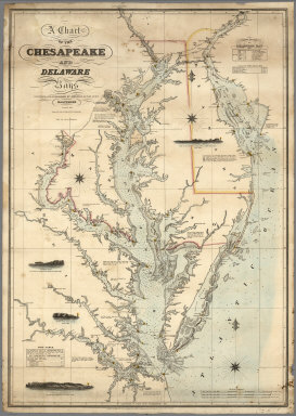
Lucas, Fielding Jr.
Full Title
A Chart of the Chesapeake And Delaware Bays Compiled And Published By Fielding Lucas Junr. Baltimore Corrected_1840. Engraved by John and William Warr Philadelphia. Entered ... 1832 by Fielding Lucas Jr. ... Maryland.
Publisher
Fielding Lucas Jr.
Author
Blunt, Edmund M. (Edmund March), 1770-1862
Full Title
Chart Of The North Atlantic Ocean, From the Equator to 65° North Latitude. According to the Latest Surveys & Observations. New York, Published by E. & G.W. Blunt, 154 Water St. Corner of Maiden Lane. 1832. Entered ... 1832, by Edmund & George W. Blunt ... New York. Additions to 1835. Engraved by W. Hooker. Lettered by D.R. Harrison. (with) three inset maps listed in Notes.
Publisher
E. & G.W. Blunt.
Author
Wilkes, Charles, 1798-1877
Full Title
Chart Of Georges Shoal & Bank, Surveyed By Charles Wilkes, Lieut. Commandant ... in U.S. brig Porpoise, schooners Maria & Hadassah. By order of the Hon. Mahlon Dickerson, Secretary of the Navy. Published under the direction of the Navy Commissioners. 1837. Drawn by J. Alden and W. May. Engraved by S. Stiles, Sherman & Smith, New-York.
Publisher
S. Stiles, Sherman & Smith
Author
United States Coast Survey
Full Title
Map of New - York Bay And Harbor And The Environs. Founded upon a Trigonometrical Survey under the direction of F.R. Hassler Superintendent of the Survey Of The Coast Of The United States. Triangulation by James Ferguson and Edmund Blunt Assistants. The Hydrography under the direction of Thomas R. Gedney Lieutenant U.S. Navy. The Topography by C. Renard, T.A. Jenkins & B.F. Sands Assists. Published in 1845. A.D. Bache Superintendent. Verified by Lieut. A.A. Humphreys ... Topography Engraved by S. Siebert & A. Rolle, Views Engraved by O.A. Lawson. Engraving supervised & Views of the Coast drawn by J. Farley. Hydrography Engraved by F. Dankworth, Lettering by F. Dankworth & J. Knight.
Publisher
U.S.
Author
[Findlay, Alexander George, 1812-1875, Laurie, Richard Holmes, Purdy, John]
Full Title
General chart of the coasts of Brasil, &c. from the River Para to Buenos-Ayres; with particular plans of the harbours. Constructed chiefly From the surveys of the Baron Roussin and Captain Wm. Hewett, adjusted by the later observations of Captain Phillip Parker King, Captain Robert Fitzroy, and other distinguished Officers of the British Royal Navy. Constructed and drawn by John Purdy and Alexr. Findlay. Junr. London. Published By Richd. H. Laurie, No. 53, Fleet Street. January 1st 1853. (With 31 inset maps listed below)
Publisher
Richd. H. Laurie.
Author
[Carleton, Osgood, Norman, William]
Full Title
A new general chart of the West Indies from the latest marine journals and surveys. Regulated and ascertained by astrological observations. I the subscriber do certify that I have carefully examined this chart copied from a London publication agreeable to Act of Parliament and find it a true and accurate copy of the original. Osgood Carleton. Teacher of Navigation and other Branches of the Mathematics. Boston, Decr. 28, 1789. Printed & Sold by W. Norman N. 13 Newbury Str.
Publisher
William Norman
Author
Arrowsmith, Aaron
Full Title
Chart Of The West Indies And Spanish Dominions In North America. By A. Arrowsmith, 1803. Jones Smith & Co. sc. Beaufort Buildgs. Strand. London Published June 1st 1803 by A. Arrowsmith No. 24 Rathbone Place. To Admiral John Willett Payne, A distinguished Native of the West Indies ... This Chart is respectfully Dedicated by his most obedient Servt. A. Arrowsmith.
Publisher
A. Arrowsmith
Author
Berghaus, Hermann
Full Title
Chart Of The World On Mercator's Projection. Constructed By Hermann Berghaus. Gotha: Justus Perthes. I. Edition 1863, X. Edition 1882. Engraved by H. Eberhardt, E. Kuhn and W. Weiler. (with 32 inset maps).
Publisher
Justus Perthes
Author
United States Coast Survey
Full Title
Entrance to San Francisco Bay California. From a Trigonometrical Survey under the direction of A.D. Bache Superintendent of the Survey Of The Coast Of The United States. Triangulation by R.D. Cutts Asst. & A.F. Rodgers Sub-Assts. Hydrography by the Party under the command of Lieut. Comdg. James Alden U.S.N. Asst. 1859. U.S. Coast Survey Office. Verified W.R. Palmer ... No. 36. Redd. Drng. by W.M.C. Fairfax, J. Lambert, & J.J. Ricketts. Engd. by J. Knight, A. Blondeau & G.B. Metzeroth. Electrotype Copy No. 2 by G. Mathiot U.S.C.S. (inset map) Sub-Sketch Of Entrance To San Francisco Bay. 1859.).
Publisher
U.S. Coast Survey
Author
U.S. Coast and Geodetic Survey
Full Title
San Francisco entrance, California. Published at Washington, D.C. September, 1903. By the U.S. Coast and Geodetic Survey, O.H. Tittmann, Superintendent. ... Additions to topography from other sources to July, 1905.
Publisher
U.S. Coast and Geodetic Survey
Author
U.S. Coast and Geodetic Survey
Full Title
United States - West Coast. San Francisco entrance, California. United States of America Department of Commerce ... Published at Washington, D.C., Dec. 1926. By the U.S. Coast and Geodetic Survey. E. Lester Jones, Director.
Publisher
U.S. Coast and Geodetic Survey
Author
La Perouse, Jean-Francois de Galaup, comte de, 1741-1788
Full Title
Mappemonde ou carte reduite des parties connues du globe pour servir au Voyage de La Perouse, fait dans les annees 1785, 86, 87, et 88. Atlas du Voyage de la Perouse no. 1. (Paris: Depot-general de la Marine, 1828)
Publisher
Depot de la Marine
Author
France. Depot-general de la Marine
Full Title
Carte reduite du Grand Ocean compris entre l'Asie et l'Amerique, redigee d'apres les observations les plus recentes et publiee pour le Service des Vaisseaux Francais. Par ordre du Ministre de la Marine, au Depot General des Cartes et Plans de la Marine et des Colonies, en 1797. Corrigee en 1818. (Paris: Depot-general de la Marine, 1828)
Publisher
Depot de la Marine
Author
La Perouse, Jean-Francois de Galaup, comte de, 1741-1788
Full Title
Carte des cotes de l'Amerique et de l'Asie depuis la Californie jusqu'a Macao, d'apres les decouvertes faites en 1787 et 1787 par les Fregates Francaises la Boussole et l'Astrolabe. P.F. Tardieu sculp. Atlas du Voyage de la Perouse no. 15. (Paris: Depot-general de la Marine, 1828)
Publisher
Depot de la Marine
Author
Vancouver, George, 1757-1798
Full Title
Carte de la partie de la cote nord-ouest de l'Amerique. Reconnue pendant les Etes de 1792, 1793 et 1794 depuis 29054' de latitude nord et 244033' de longitude orientale, jusqu'a au Cap Douglas par 58052' de latitude et 207020' de longitude, par le Capitaine Georges Vancouver commandant la Decouverte et le Chatham; avec les routes de ces deux batimens; Redigee par le Lieutenant Edward Roberts d'apres les reconnaissances et les observations. Voyage de Vancouver. No. 3. (Paris: Depot-general de la Marine, 1828)
Publisher
Depot de la Marine
Author
Vancouver, George, 1757-1798
Full Title
Cote nord-ouest de l'Amerique. Reconnue par le Cape. Vancouver. 1e. partie, depuis 3000' de latitude septle. et 244032' de longitude jusqu'a 38030' de late. et 237013' de longe. (with) Port St. Diego. (with) Entree de Port St. Francisco. Voyage de Vancouver. No. 4. (Paris: Depot-general de la Marine, 1828)
Publisher
Depot de la Marine
Author
Vancouver, George, 1757-1798
Full Title
Cote nord-ouest de l'Amerique. Reconnue par le Cape. Vancouver. 2e. partie, depuis 38015' de latitude septle. et 237027' de longitude jusqu'a 45046' de late. et 236015' de longe. (with) Baie de la Trinidad. Voyage de Vancouver. No. 5. (Paris: Depot-general de la Marine, 1828)
Publisher
Depot de la Marine
Author
Vancouver, George, 1757-1798
Full Title
Cote nord-ouest de l'Amerique. Reconnue par le Cape. Vancouver. 3e. partie, depuis 45030' de latitude septle. et 236012' de longitude, jusqu'a 52015' de late. et 232040' de longe. (with) Havre de Gray. (with) Port de la Decouverte. (with) Entree de la Riviere Columbia. Voyage de Vancouver. No. 6. (Paris: Depot-general de la Marine, 1828)
Publisher
Depot de la Marine
Author
Vancouver, George, 1757-1798
Full Title
Cote nord-ouest de l'Amerique. Reconnue par le Cape. Vancouver. IVe. partie, depuis 51045' de latitude septentle. et 23208' de longitude, jusqu'a 57030' de latitde. et 226044' de longe. (with) Plan du Port Stewart. Voyage de Vancouver. No. 7. (Paris: Depot-general de la Marine, 1828)
Publisher
Depot de la Marine
Author
Vancouver, George, 1757-1798
Full Title
Cote nord-ouest de l'Amerique. Reconnue par le Cape. Vancouver. Ve. partie, depuis 5707'30" de latitude septle. et 22700' de longitude, jusqu'a 59059' de late. et 21900' de longe. (with) Plan du Port Conclusion. (with) Plan de Port Protection. (with) Plan de l'entree de Cross-Sound. Voyage de Vancouver. No. 8. (Paris: Depot-general de la Marine, 1828)
Publisher
Depot de la Marine
|