Who What Where WhenREMOVE |
Author
Arrowsmith, Aaron
Full Title
Coast of Africa, from Cabo Verde to Cabo Formosa, drawn from Various Geographical M.S.S. by A. Arrowsmith. (insets) Kingdom of Kayor. Vagres, Naloos, Bagos, Soosees.
Publisher
Cadell & Davies
Author
Arrowsmith, Aaron
Full Title
Coast of Africa from Cabo Formosa to the Cabo de Boa Esperaca, drawn from a variety of Geographical M.S.S. by A. Arrowsmith. (insets) St. Elena Bay. Cabo do Santa Catherina
Publisher
Cadell & Davies
Author
Arrowsmith, Aaron
Full Title
Southern Coast of Africa drawn fro a Variety of Geographical M.S.S. by A. Arrowsmith.
Publisher
Cadell & Davies
Author
Cook, James, 1728-1779
Full Title
A chart of the southern extremity of America 1775. (with) Part of Staten Land. No. II. Published Febry. 1st, 1777 by Wm. Strahan in New Street, Shoe Lane & Thos. Cadell in the Strand, London.
Publisher
W. Strahan and T. Cadell
Author
Cook, James, 1728-1779
Full Title
Chart of the discoveries made in the South Atlantic Ocean in his majesty's ship Resolution, under the command of Captain Cook in Jany. 1775. J. Russell sculp. No. IV. Published Febry. 1st, 1777 by Wm. Strahan in New Street, Shoe Lane & Thos. Cadell in the Strand, London.
Publisher
W. Strahan and T. Cadell
Author
Cook, James, 1728-1779
Full Title
Kerguelen's Land called by C. Cook Island of Desolation. (with) Islands discovered by M. Marion du Fresne 1772 called by C. Cook in 1776 Prince Edward Isles. Writing by Harmar. (Drawn by Lieut. Henry Roberts. London: G. Nicol and T. Cadell, 1785)
Publisher
G. Nicol and T. Cadell
Author
Cook, James, 1728-1779
Full Title
Sketch of Port Palliser on Kerguelen's-Land. Plan of Christmas Harbour on Kerguelen's-Land. 1777. (Copied by Lieut. Henry Roberts. London, G. Nicol and T. Cadell, 1785)
Publisher
G. Nicol and T. Cadell
Author
[Bligh, William, 1754-1817, Cook, James, 1728-1779]
Full Title
Three views of Arched Point on Kerguelen's Land. View when Arched Point bears So. 2 1/2 miles distant. View of Kerguelen's Land 4 1/2 miles distant. View of Kerguelen's Land when Prince of Wales's Foreland bears W.S.W. (By William Bligh. London, G. Nicol and T. Cadell, 1785)
Publisher
G. Nicol and T. Cadell
Author
[Bligh, William, 1754-1817, Cook, James, 1728-1779]
Full Title
Chart of Van Diemen's Land. Harmar script. (By William Bligh. London, G. Nicol and T. Cadell, 1785)
Publisher
G. Nicol and T. Cadell
Author
Cook, James, 1728-1779
Full Title
Plan of Adventure Bay in Van Diemens Land. (with) View of the south side of Adventure Bay. (Copied by Lieut. Henry Roberts. London, G. Nicol and T. Cadell, 1785)
Publisher
G. Nicol and T. Cadell
Author
[Bligh, William, 1754-1817, Cook, James, 1728-1779]
Full Title
Chart of the Friendly Islands. Writing by W. Harrison. (By William Bligh and James Cook. London, G. Nicol and T. Cadell, 1785)
Publisher
G. Nicol and T. Cadell
Author
[Bligh, William, 1754-1817, Cook, James, 1728-1779]
Full Title
Sketch of Tongataboo Harbour, 1777. The writing engraved by Mw. Smith. (By William Bligh. London, G. Nicol and T. Cadell, 1785)
Publisher
G. Nicol and T. Cadell
Author
[Bligh, William, 1754-1817, Cook, James, 1728-1779]
Full Title
(Plans of islands in the South Pacific. Wanooaette I. Wateeoo I. Mangeea Island. Toobouai Island. By William Bligh. London, G. Nicol and T. Cadell, 1785)
Publisher
G. Nicol and T. Cadell
Author
[Bligh, William, 1754-1817, Cook, James, 1728-1779, Edgar, Thomas]
Full Title
Sketch of the harbours on the north side of Eimeo. (By William Bligh and Thomas Edgar. London, G. Nicol and T. Cadell, 1785)
Publisher
G. Nicol and T. Cadell
Author
[Bligh, William, 1754-1817, Cook, James, 1728-1779]
Full Title
Christmas Island. Latitude 1058' N. Longitude 202028' E. Discovered in the ships Resolution and Discovery, 1777 ... (By William Bligh. London, G. Nicol and T. Cadell, 1785)
Publisher
G. Nicol and T. Cadell
Author
[Bligh, William, 1754-1817, Cook, James, 1728-1779, Webber, John, 1751-1793]
Full Title
Views on the west coast of America. (London, G. Nicol and T. Cadell, 1785)
Publisher
G. Nicol and T. Cadell
Author
Cook, James, 1728-1779
Full Title
Sketch of Nootka Sound ... 1778. The writing engraved by Mw. Smith. (Copied by Lieut. Henry Roberts. London, G. Nicol and T. Cadell, 1785)
Publisher
G. Nicol and T. Cadell
Author
Cook, James, 1728-1779
Full Title
Chart of Cooks River in the N.W. part of America. Writing by W. Harrison. (Copied by Lieut. Henry Roberts. London, G. Nicol and T. Cadell, 1785)
Publisher
G. Nicol and T. Cadell
Author
[Bligh, William, 1754-1817, Cook, James, 1728-1779, Webber, John, 1751-1793]
Full Title
Views of the land on the west coast of America, to the westward of Cook's River. J. Webber. (Engraved after J. Webber and W. Bligh. London, G. Nicol and T. Cadell, 1785)
Publisher
G. Nicol and T. Cadell
Author
[Bligh, William, 1754-1817, Cook, James, 1728-1779]
Full Title
Sketch of the harbour of Samganooda on the island Oonalaska. Harmar scr: (Copied by Lieut. Henry Roberts. London, G. Nicol and T. Cadell, 1785)
Publisher
G. Nicol and T. Cadell
Author
Cook, James, 1728-1779
Full Title
Chart of Norton Sound and of Bherings Strait made by the East Cape of Asia and the West Point of America. (Copied by Lieut. Henry Roberts. London, G. Nicol and T. Cadell, 1785)
Publisher
G. Nicol and T. Cadell
Author
[Bligh, William, 1754-1817, Cook, James, 1728-1779, Webber, John, 1751-1793]
Full Title
Views on the coast of Asia. J. Webber del. (Engraved after J. Webber and W. Bligh. London, G. Nicol and T. Cadell, 1785)
Publisher
G. Nicol and T. Cadell
Author
[Bligh, William, 1754-1817, Cook, James, 1728-1779, Webber, John, 1751-1793]
Full Title
Sandwich Islands. (After missing views by Bligh and possibly Webber. London, G. Nicol and T. Cadell, 1785)
Publisher
G. Nicol and T. Cadell
Author
[Bligh, William, 1754-1817, Cook, James, 1728-1779, Roberts, Henry, Lieut.]
Full Title
Chart of the Sandwich Islands. (with) Sketch of Karakakooa Bay. The writing by W. Harrison. (By Henry Roberts; after missing survey by William Bligh. London, G. Nicol and T. Cadell, 1785)
Publisher
G. Nicol and T. Cadell
Author
[Bligh, William, 1754-1817, Cook, James, 1728-1779]
Full Title
Plan of the Bay of Awatska on the east coast of Kamtschatka. (with) Plan of the harbour of St. Peter and St. Paul, surveyed by William Bligh, master of the Resolution. (Engraved by) W. H(arrison. London, G. Nicol and T. Cadell, 1785)
Publisher
G. Nicol and T. Cadell
Author
[Bligh, William, 1754-1817, Cook, James, 1728-1779, Webber, John, 1751-1793]
Full Title
Views on the coast of Kamtschatka. (Engraved after Webber and Bligh. London, G. Nicol and T. Cadell, 1785)
Publisher
G. Nicol and T. Cadell
Author
[Bligh, William, 1754-1817, Cook, James, 1728-1779, Webber, John, 1751-1793]
Full Title
Part of Japan or Nipon. (with) View of the coast of Japan when we first saw it. (Engraved by) W. H(arrison after a missing survey possibly by Bligh and a view by Webber. London, G. Nicol and T. Cadell, 1785)
Publisher
G. Nicol and T. Cadell
Author
[Bligh, William, 1754-1817, Cook, James, 1728-1779]
Full Title
(Chart of Sulphur Island and vicinity). (with) View of Sulphur Island bearing E.N.E. Harmar scr. (After a missing survey possibly by Bligh and a view possibly by Ellis. London, G. Nicol and T. Cadell, 1785)
Publisher
G. Nicol and T. Cadell
Author
[Bligh, William, 1754-1817, Cook, James, 1728-1779]
Full Title
Sketch of the Typa and Macao. (Engraved by) W. H(arrison after a missing survey by William Bligh. London, G. Nicol and T. Cadell, 1785)
Publisher
G. Nicol and T. Cadell
Author
[Cook, James, 1728-1779, Roberts, Henry, Lieut.]
Full Title
A general chart: exhibiting the discoveries made by Captn. James Cook in this and his two preceding voyages, with the tracks of the ships under his command. By Lieut. Heny. Roberts of his Majesty's Royal Navy. W. Palmer sculp. (London, G. Nicol and T. Cadell, 1785)
Publisher
G. Nicol and T. Cadell
Author
Cook, James, 1728-1779
Full Title
Chart of the N.W. coast of America and N.E. coast of Asia explored in the years 1778 & 1779. The unshaded parts of the coast of Asia are taken from a MS chart received from the Russians. Writing engraved by T. Harmar. (Copied by Lieut. Henry Roberts. London, G. Nicol and T. Cadell, 1785)
Publisher
G. Nicol and T. Cadell
Author
Bradstreet Company
Full Title
Track Chart of the Cunard Line. Showing the Route taken by the Company's Streamers.
Publisher
Bradstreet Co.
Author
[Byron, John, 1723-1786, Hawkesworth, John, 1715?-1773]
Full Title
Cordes Bay and Harbour. (with) Port Famine. (with) Woods Bay. (with) Port Gallant and Fortescue Bay. (London: printed for W. Strahan; and T. Cadell in the Strand, MDCCLXXIII)
Publisher
W. Strahan and T. Cadell
Author
[Byron, John, 1723-1786, Hawkesworth, John, 1715?-1773]
Full Title
Cape Providence with the bay and anchoring places to the N.N.E. of it. (with) St. David's Cove. (with) Island Bay. (with) Puzling Bay. (with) Cape Upright Bay. (with) Dolphin Bay. (London: printed for W. Strahan; and T. Cadell in the Strand, MDCCLXXIII)
Publisher
W. Strahan and T. Cadell
Author
[Byron, John, 1723-1786, Hawkesworth, John, 1715?-1773]
Full Title
From York Bay to Three Island Bay and Harbour. (with) Elizabeth Bay. (with) A bay under the islands opposite York Road. (with) St. Davids Bay. (London: printed for W. Strahan; and T. Cadell in the Strand, MDCCLXXIII)
Publisher
W. Strahan and T. Cadell
Author
[Byron, John, 1723-1786, Hawkesworth, John, 1715?-1773]
Full Title
A chart of Hawkins's Maidenland, discovered by Sr. Richard Hawkins in 1574 and Falkland Sound, so called by Capn. John Strong of the Farewell from London who sailed through it in 1689. Isa: Noual sculp. No. 23. [London: printed for W. Strahan; and T. Cadell in the Strand, MDCCLXXIII).
Publisher
W. Strahan and T. Cadell
Author
[Hawkesworth, John, 1715?-1773, Wallis, Samuel, 1728-1795]
Full Title
Sir Charles Saunders Island. (with) Osnaburg Island. (with) Boscawens Island. (with) Adml. Keppels Island. (with) Wallis's Island. [London: printed for W. Strahan; and T. Cadell in the Strand, MDCCLXXIII).
Publisher
W. Strahan and T. Cadell
Author
[Hawkesworth, John, 1715?-1773, Wallis, Samuel, 1728-1795]
Full Title
(Cocos Island called by C. Wallis Boscawen. Traitors Island called by C. Wallis Keppel. London: printed for W. Strahan; and T. Cadell in the Strand, MDCCLXXIII).
Publisher
W. Strahan and T. Cadell
Author
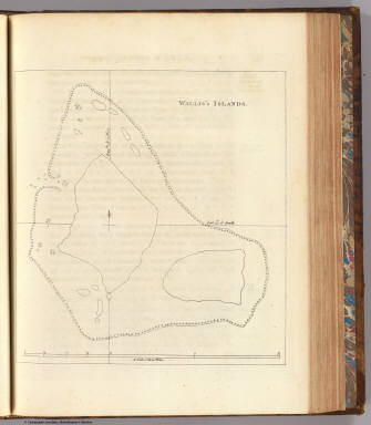
[Hawkesworth, John, 1715?-1773, Wallis, Samuel, 1728-1795]
Full Title
Wallis's Islands. (London: printed for W. Strahan; and T. Cadell in the Strand, MDCCLXXIII).
Publisher
W. Strahan and T. Cadell
Author
[Carteret, Philip, d. 1796, Hawkesworth, John, 1715?-1773]
Full Title
A view of the N.W. side of Mas-a-fuera. Wallis's Islands. (London: printed for W. Strahan; and T. Cadell in the Strand, MDCCLXXIII).
Publisher
W. Strahan and T. Cadell
Author
[Carteret, Philip, d. 1796, Hawkesworth, John, 1715?-1773]
Full Title
A chart and views of Pitcairns Island ... Bayly sculp. 1st. Jany., 1773. (London: printed for W. Strahan; and T. Cadell in the Strand, MDCCLXXIII).
Publisher
W. Strahan and T. Cadell
Author
[Carteret, Philip, d. 1796, Hawkesworth, John, 1715?-1773]
Full Title
Queen Charlotte's Islands. Bayly sculpt. Jany. 1st, 1773. (London: printed for W. Strahan; and T. Cadell in the Strand, MDCCLXXIII).
Publisher
W. Strahan and T. Cadell
Author
[Carteret, Philip, d. 1796, Hawkesworth, John, 1715?-1773]
Full Title
The north side of the largest of Queen Charlotte's Islands as it appeared running along shore to the westward. Publish'd Novr. 1st, 1772. (London: printed for W. Strahan; and T. Cadell in the Strand, MDCCLXXIII).
Publisher
W. Strahan and T. Cadell
Author
[Carteret, Philip, d. 1796, Hawkesworth, John, 1715?-1773]
Full Title
Nova Hibernia. Publish'd Novr. 1st, 1772. (London: printed for W. Strahan; and T. Cadell in the Strand, MDCCLXXIII).
Publisher
W. Strahan and T. Cadell
Author
[Carteret, Philip, d. 1796, Hawkesworth, John, 1715?-1773]
Full Title
A chart of Captn. Carteret's discoveries at New Britain, with part of Captn. Cooke's passage thro Endeavor Streights, & of Captn. Dampier's tract & discoveries in 1699, & 1700, at New Guinea and New Britain. Engraved by W. Whitchurch, Pleasant Row, Islington. (London: printed for W. Strahan; and T. Cadell in the Strand, MDCCLXXIII).
Publisher
W. Strahan and T. Cadell
Author
[Carteret, Philip, d. 1796, Hawkesworth, John, 1715?-1773]
Full Title
Three views of the Admiralty Isles. (with 6 other coastal views of Joseph Freewills Islands, Current Island, St. Andrews Islands, bay at south end of Mindanao). Publish'd Novr. 1st, 1772. (London: printed for W. Strahan; and T. Cadell in the Strand, MDCCLXXIII).
Publisher
W. Strahan and T. Cadell
Author
[Carteret, Philip, d. 1796, Hawkesworth, John, 1715?-1773]
Full Title
A dangerous shoal seen Septr. the 28, 1767. (with) Joseph Freewills Islands. (with) The south end of Mindanao. (London: printed for W. Strahan; and T. Cadell in the Strand, MDCCLXXIII).
Publisher
W. Strahan and T. Cadell
Author
[Carteret, Philip, d. 1796, Hawkesworth, John, 1715?-1773]
Full Title
A draught of Bonthain Bay situated about 30 leagues to the S.E. of Macassar in the Island of Celebes. Publish'd Novr. 4th, 1772. (London: printed for W. Strahan; and T. Cadell in the Strand, MDCCLXXIII).
Publisher
W. Strahan and T. Cadell
Author
[Cook, James, 1728-1779, Hawkesworth, John, 1715?-1773]
Full Title
A plan of Success Bay in Strait le Maire. A chart of the S.E. part of Terra del Fuego including Strait le Maire and part of Staten-land by Lieutenant J. Cook 1769. T. Bowen & J. Gibson sculp. (London: printed for W. Strahan; and T. Cadell in the Strand, MDCCLXXIII).
Publisher
W. Strahan and T. Cadell
Author
[Cook, James, 1728-1779, Hawkesworth, John, 1715?-1773]
Full Title
Chart of the island Otaheite, by Lieut. J. Cook, 1769. J. Cheevers sculp. (London: printed for W. Strahan; and T. Cadell in the Strand, MDCCLXXIII).
Publisher
W. Strahan and T. Cadell
|