|
REFINE
Browse All : County Atlas and Property Ownership and Atlas MapAuthor
Kingman Brothers.
Full Title
Map of Harrison Township. North Grove.
Publisher
Kingman Brothers.
Author
Kingman Brothers.
Full Title
Map of Jackson Township. Amboy.
Publisher
Kingman Brothers.
Author
Kingman Brothers.
Full Title
Xenia. Birmingham. Lincoln.
Publisher
Kingman Brothers.
Author
Kingman Brothers.
Full Title
Map of Perry Township.
Publisher
Kingman Brothers.
Author
Kingman Brothers.
Full Title
Bunker Hill, Bennetts Switch, Stockdale.
Publisher
Kingman Brothers.
Author
Kingman Brothers.
Full Title
Map of Washington Township.
Publisher
Kingman Brothers.
Author
Kingman Brothers.
Full Title
Map of Jefferson Township.
Publisher
Kingman Brothers.
Author
Kingman Brothers.
Full Title
Mexico (Indiana). Denver (Indiana).
Publisher
Kingman Brothers.
Author
Kingman Brothers.
Full Title
Map of Allen Township. Gilead.
Publisher
Kingman Brothers.
Author
Kingman Brothers.
Full Title
Map of Union Township. Perrysburg. Union. Deedsville.
Publisher
Kingman Brothers.
Author
Kingman Brothers.
Full Title
Map of Butler Township. Santafee. Peoria, Reserve P.O.
Publisher
Kingman Brothers.
Author
Kingman Brothers.
Full Title
Map of Erie Township. Chili.
Publisher
Kingman Brothers.
Author
Kingman Brothers.
Full Title
Map of Richland Township. Paw Paw.
Publisher
Kingman Brothers.
Author
Andreas, A. T. (Alfred Theodore), 1839-1900
Full Title
Map of Washington Township.
Publisher
A.T. Andreas
Author
Andreas, A. T. (Alfred Theodore), 1839-1900
Full Title
Map of Yellow Springs Township. (insets) Map of Kossuth. Map of Northfield. Map of Pleasant Grove. Map of Danville. Map of Mediapolis. Map of Middletown.
Publisher
A.T. Andreas
Author
Andreas, A. T. (Alfred Theodore), 1839-1900
Full Title
Map of Huron Township. Map of Jackson Township.
Publisher
A.T. Andreas
Author
Andreas, A. T. (Alfred Theodore), 1839-1900
Full Title
Map of Benton Township.
Publisher
A.T. Andreas
Author
Andreas, A. T. (Alfred Theodore), 1839-1900
Full Title
Map of Franklin Township.
Publisher
A.T. Andreas
Author
Andreas, A. T. (Alfred Theodore), 1839-1900
Full Title
Map of Pleasant Grove Township.
Publisher
A.T. Andreas
Author
Andreas, A. T. (Alfred Theodore), 1839-1900
Full Title
Map of Danville Township.
Publisher
A.T. Andreas
Author
Andreas, A. T. (Alfred Theodore), 1839-1900
Full Title
Map of Flint River Township.
Publisher
A.T. Andreas
Author
Andreas, A. T. (Alfred Theodore), 1839-1900
Full Title
Map of the City of Burlington, Des Moines Co., Iowa, 1873.
Publisher
A.T. Andreas
Author
Andreas, A. T. (Alfred Theodore), 1839-1900
Full Title
Map of Burlington Township. (insets) Map of Kingston. Map of Dodgeville. Map of Sperry.
Publisher
A.T. Andreas
Author
Andreas, A. T. (Alfred Theodore), 1839-1900
Full Title
Map of Union Township.
Publisher
A.T. Andreas
Author
Andreas, A. T. (Alfred Theodore), 1839-1900
Full Title
Map of Augusta Township. (inset) Map of Augusta.
Publisher
A.T. Andreas
Author
Beers, J.H. & Co.
Full Title
Brookville.
Publisher
J.H. Beers
Author
Beers, J.H. & Co.
Full Title
Cedar Grove Formerly Rochester, Peppertown, New Trenton, South Gate, Scipio, Drewersburg (Laid Out as Edinburg).
Publisher
J.H. Beers
Author
Beers, J.H. & Co.
Full Title
Map of Metamora Township. Metamora. St. Mary's, Haymond P.O. St. Philomena, Oak Forest P.O.
Publisher
J.H. Beers
Author
Beers, J.H. & Co.
Full Title
Map of Brookville Township, Franklin County, Indiana. Fairfield. Union, Whitcomb P.O., Indiana.
Publisher
J.H. Beers
Author
Beers, J.H. & Co.
Full Title
Map of Springfield Township.
Publisher
J.H. Beers
Author
Beers, J.H. & Co.
Full Title
Map of Bath Township. Map of Fairfield Township.
Publisher
J.H. Beers
Author
Beers, J.H. & Co.
Full Title
Map of Blooming Grove Township. Blooming Grove. Mixerville.
Publisher
J.H. Beers
Author
Beers, J.H. & Co.
Full Title
Map of Laurel Township.
Publisher
J.H. Beers
Author
Beers, J.H. & Co.
Full Title
Map of Posey Township. Andersonville (Formerly Ceylon), Mt. Carmel, Buena Vista, Hamburg, and Palestine.
Publisher
J.H. Beers
Author
Beers, J.H. & Co.
Full Title
Laurel.
Publisher
J.H. Beers
Author
Beers, J.H. & Co.
Full Title
Map of Salt Creek Township.
Publisher
J.H. Beers
Author
Beers, J.H. & Co.
Full Title
Map of Ray Township. Oldenburg. Enochsburg. Huntersville.
Publisher
J.H. Beers
Author
Beers, J.H. & Co.
Full Title
Map of Butler Township.
Publisher
J.H. Beers
Author
Beers, J.H. & Co.
Full Title
Map of Highland Township. Village and Catholic Church of St. Peter.
Publisher
J.H. Beers
Author
Beers, J.H. & Co.
Full Title
Map of White Water Township.
Publisher
J.H. Beers
Author
Beers, J.H. & Co.
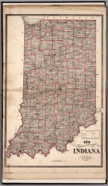
Full Title
Sectional and Township Map of Indiana. 1882.
Publisher
J.H. Beers
Author
Beers, J.H. & Co.
Full Title
New Railroad Map of the United States.
Publisher
J.H. Beers
Author
Beers, J.H. & Co.
Full Title
Western Hemisphere. Eastern Hemisphere.
Publisher
J.H. Beers
Author
Pinkney & Brown
Full Title
Plat of Cady.
Publisher
F. Bourquin
Author
Pinkney & Brown
Full Title
Plat of Springfield.
Publisher
F. Bourquin
Author
Pinkney & Brown
Full Title
Plat of Glenwood.
Publisher
F. Bourquin
Author
Pinkney & Brown
Full Title
Plat of Forest.
Publisher
F. Bourquin
Author
Pinkney & Brown
Full Title
Plat of Eau Galle.
Publisher
F. Bourquin
Author
Pinkney & Brown
Full Title
Plat of Baldwin.
Publisher
F. Bourquin
|