|
|
Author
Macomb, J.N.
Full Title
(Title Page to) Report of the Exploring Expedition From Santa Fe, New Mexico, To The Junction of the Grand and Green Rivers of the Great Colorado of the West, In 1859, Under the Command of Capt. J.N. Macomb, Corps of Topographical Engineers (Now Colonel of Engineers); With A Geological Report by Prof. J.S. Newberry, Geologist of the Expedition. Washington: Government Printing Office. 1876.
Publisher
Washington: U.S.
Author
[Macomb, J.N., Egloffstein, F.W.]
Full Title
Map of Exploration and Surveys in New Mexico and Utah made under the direction of the Secretary of War by Capt. J.N. Macomb Topl. Engrs. assisted by C.H. Dimmock, C. Engr. 1860. Lettering by John L. Hazzard. Ruling by Samuel Sartain. Constructed and Engraved by Baron F.W. Von Egloffstein.
Publisher
Washington: U.S.
Author
[Dutton, Clarence E. (Clarence Edward), 1841-1912, Geographical and Geological Survey of the Rocky Mountain Region (U.S.)]
Full Title
(covers to) Topographical and geological atlas of the district of the high plateaus of Utah to accompany the report of Capt. C.E. Dutton, U.S. Ordnance Corps, assistant geologist. Julius Bien, Lith., New York, 1879.
Publisher
U.S. Geographical and Geological Survey of the Rocky Mountain Region
Author
[Dutton, Clarence E. (Clarence Edward), 1841-1912, Geographical and Geological Survey of the Rocky Mountain Region (U.S.)]
Full Title
(Title Page to) Topographical and geological atlas of the district of the high plateaus of Utah to accompany the report of Capt. C.E. Dutton, U.S. Ordnance Corps, assistant geologist. Julius Bien, Lith., New York, 1879.
Publisher
U.S. Geographical and Geological Survey of the Rocky Mountain Region
Author
[Geographical and Geological Survey of the Rocky Mountain Region (U.S.), Graves, W. H., Renshawe, J. H. (John Henry), 1852-, Thompson, A. H. (Almon Harris), 1839-1906]
Full Title
Map of the district of the High Plateaus of Utah. Triangulation by A.H. Thompson, topographers J.H. Renshawe, W.H. Graves. Dept. of the Interior, U.S. G. and G. Survey, J.W. Powell in charge. Atlas sheet no. 1, Geology of the high plateaus of Utah by Capt. C.E. Dutton, U.S.A. (Julius Bien, Lith., New York, 1879)
Publisher
U.S. Geographical and Geological Survey of the Rocky Mountain Region
Author
[Dutton, Clarence E. (Clarence Edward), 1841-1912, Geographical and Geological Survey of the Rocky Mountain Region (U.S.), Graves, W. H., Renshawe, J. H. (John Henry), 1852-, Thompson, A. H. (Almon Harris), 1839-1906]
Full Title
Geological map of the district of the high plateaus of Utah. Triangulation by A.H. Thompson, topographers J.H. Renshawe, W.H. Graves. Geology by Capt. C.E. Dutton, U.S.A. Dept. of the Interior, U.S. G. and G. Survey, J.W. Powell in charge. Atlas sheet no. 2, Geology of the high plateaus of Utah by Capt. C.E. Dutton, U.S.A. (Julius Bien, Lith., New York, 1879)
Publisher
U.S. Geographical and Geological Survey of the Rocky Mountain Region
Author
[Dutton, Clarence E. (Clarence Edward), 1841-1912, Geographical and Geological Survey of the Rocky Mountain Region (U.S.)]
Full Title
Relief map of the district of the high plateaus of Utah. Dept. of the Interior, U.S. G. and G. Survey, J.W. Powell in charge. Atlas sheet no. 3, Geology of the high plateaus of Utah by Capt. C.E. Dutton, U.S.A. (Julius Bien, Lith., New York, 1879)
Publisher
U.S. Geographical and Geological Survey of the Rocky Mountain Region
Author
[Dutton, Clarence E. (Clarence Edward), 1841-1912, Geographical and Geological Survey of the Rocky Mountain Region (U.S.)]
Full Title
Map of portions of Utah and Arizona showing the arrangement of faults and flexures in the Kaibabs and high plateaus. Dept. of the Interior, U.S. G. and G. Survey, J.W. Powell in charge. Atlas sheet no. 4, Geology of the high plateaus of Utah by Capt. C.E. Dutton, U.S.A. (Julius Bien, Lith., New York, 1879)
Publisher
U.S. Geographical and Geological Survey of the Rocky Mountain Region
Author
[Dutton, Clarence E. (Clarence Edward), 1841-1912, Geographical and Geological Survey of the Rocky Mountain Region (U.S.)]
Full Title
Stereogram of displacements in the district of the high plateaus of Utah. Showing the vertical displacements of a given horizon since the close of the Green River epoch, with the supposition that there had been no erosion. By C.E. Dutton, Capt. of Ordnance, U.S.A. Dept. of the Interior, U.S. G. and G. Survey, J.W. Powell in charge. Atlas sheet no. 5, Geology of the high plateaus of Utah by Capt. C.E. Dutton, U.S.A. (Julius Bien, Lith., New York, 1879)
Publisher
U.S. Geographical and Geological Survey of the Rocky Mountain Region
Author
[Dutton, Clarence E. (Clarence Edward), 1841-1912, Geographical and Geological Survey of the Rocky Mountain Region (U.S.)]
Full Title
Structure sections through the high plateaus. Dept. of the Interior, U.S. G. and G. Survey, J.W. Powell in charge. Atlas sheet no. 6, Geology of the high plateaus of Utah by Capt. C.E. Dutton, U.S.A. (Julius Bien, Lith., New York, 1879)
Publisher
U.S. Geographical and Geological Survey of the Rocky Mountain Region
Author
[Dutton, Clarence E. (Clarence Edward), 1841-1912, Geographical and Geological Survey of the Rocky Mountain Region (U.S.)]
Full Title
Structure sections through the high plateaus. Dept. of the Interior, U.S. G. and G. Survey, J.W. Powell in charge. Atlas sheet no. 7, Geology of the high plateaus of Utah by Capt. C.E. Dutton, U.S.A. (Julius Bien, Lith., New York, 1879)
Publisher
U.S. Geographical and Geological Survey of the Rocky Mountain Region
Author
[Dutton, Clarence E. (Clarence Edward), 1841-1912, Geographical and Geological Survey of the Rocky Mountain Region (U.S.), Graves, W. H., Lindenkohl, H. (Henry), Mahon, Charles]
Full Title
Map of Utah Territory compiled and drawn by Charles Mahon, J.H. Renshawe, W.H. Graves and H. Lindenkohl. Dept. of the Interior, U.S. G. and G. Survey, J.W. Powell in charge. Atlas sheet no. 8, Geology of the high plateaus of Utah by Capt. C.E. Dutton, U.S.A. (Julius Bien, Lith., New York, 1879)
Publisher
U.S. Geographical and Geological Survey of the Rocky Mountain Region
Author
[Macomb, J.N., Newberry, J.S.]
Full Title
(View) Plate VI. Casa Colorado & La Sal-Mountains. Looking Northerly. J.J. Young from a sketch by Dr. J.S. Newberry. T. Sinclair & Son. lith. Phila.
Publisher
U.S. Government Printing Office
Author
[Macomb, J.N., Newberry, J.S.]
Full Title
(View) Ruins of Stone Houses Cliffs, Labyrinth Canyon. J.S.N. T. Sinclair & Son. lith. Phila.
Publisher
U.S. Government Printing Office
Author
[Macomb, J.N., Newberry, J.S.]
Full Title
(View) Plate VII. Head of Labyrinth Creek. Looking South-Easterly. J.J. Young from a sketch by Dr. J.S. Newberry. T. Sinclair & Son. lith. Phila.
Publisher
U.S. Government Printing Office
Author
[Macomb, J.N., Newberry, J.S.]
Full Title
(View) Plate IX. Lower San Juan, Looking West from Near Camp 35. J.J. Young from a sketch by Dr. J.S. Newberry. T. Sinclair & Son. lith. Phila.
Publisher
U.S. Government Printing Office
Full Title
Diurnal force of vapor. Pioche, Nev. Ft. Steele, Wyo. Terr. Prescott, Ariz. Ogden, Utah. Trinidad, Col. Cheyenne, Wyo. U.S. Geographical Surveys West of the 100th Meridian. (1877)
Publisher
U.S.
Full Title
(Diurnal) relative humidity. Georgetown, Col. Los Angeles, Cal. Colorado Springs, Col. Salt Lake City, Utah. Santa Fe, New Mex. Green River, Wyo. Terr. U.S. Geographical Surveys West of the 100th Meridian. (1877)
Publisher
U.S.
Full Title
Diurnal relative humidity. Camp Independence, Cal. Cottonwood Springs, Nev. Beaver, Utah. Hughes, Col. Labran, Col. U.S. Geographical Surveys West of the 100th Meridian. (1877)
Publisher
U.S.
Full Title
Rain sculpture, Salt Creek Canon, Utah. (1875)
Publisher
U.S.
Full Title
Rock carved by drifting sand, near mouth of Grand Wash, Utah. (1875)
Publisher
U.S.
Full Title
Lava from valley of Lower Sevier, Utah. (1875)
Publisher
U.S.
Full Title
Cretaceous. P. Roetter del. J. Bien lith. (1877)
Publisher
U.S.
Author
[Beckwith, Lieut., Schumann, C.]
Full Title
Weber Lower Canyon. April 5th at 2 P.M. from an island in Weber River; Valley of Great Salt Lake. C. Schumann from F.W. Egloffstein. Selmar Siebert's Engraving & Printing Establishment, Washington, D.C. U.S.P.R.R. Exp. & Surveys 41st Parallel. Expl. by Lieut. Beckwith. Vol. II.
Publisher
[A.O.P. Nicholson I-XI, T. Ford XII.]
Author
[Beckwith, Lieut., Hinshelwood, R., Schumann, C.]
Full Title
Second or Sheeprock Canyon of Weber River. April 6th at 1 P.M. View Looking East. C. Schumann from F.W. Egloffstein. R. Hinshelwood. U.S.P.R.R. Exp. & Surveys 41st Parallel. Expl. by Lieut. Beckwith. Vol. II.
Publisher
[A.O.P. Nicholson I-XI, T. Ford XII.]
Author
[Beckwith, Lieut., Schumann, C.]
Full Title
Porcupine Terrace. Uintah Mountains in the Distance. Camp. April 16th to 17th. C. Schumann from F.W. Egloffstein. Selmar Siebert's Engraving & Printing Establishment, Washington, D.C. U.S.P.R.R. Exp. & Surveys 41st Parallel. Expl. by Lieut. Beckwith. Vol. II.
Publisher
[A.O.P. Nicholson I-XI, T. Ford XII.]
Author
[Beckwith, Lieut., Schumann, C.]
Full Title
Round Prairie From Head of the Same. April 21st at 10 A.M. C. Schumann from F.W. Egloffstein. S.V. Hunt Sc. U.S.P.R.R. Exp. & Surveys 41st Parallel. Expl. by Lieut. Beckwith. Vol. II.
Publisher
[A.O.P. Nicholson I-XI, T. Ford XII.]
Author
[Beckwith, Lieut., Schumann, C.]
Full Title
Goshoot Passage showing 65 miles of the proposed line of railroad from the desert west of Great Salt Lake to the Humboldt Mountains. May 17th-20th. C. Schumann from F.W. Egloffstein. Selmar Siebert's Engraving & Printing Establishment, Washington, D.C. U.S.P.R.R. Exp. & Surveys 41st Parallel. Expl. by Lieut. Beckwith. Vol. II.
Publisher
[A.O.P. Nicholson I-XI, T. Ford XII.]
Author
Beckwith, E.G.
Full Title
From the Valley of Green River to the Great Salt Lake; from Explorations and Surveys made under the direction of the Hon. Jefferson Davis Secretary of War by Capt. E.G. Beckwith, 3d. Artillery. F.W. Egloffstein, Topographer for the Route. 1855. Explorations and surveys for a railroad route from the Mississippi River to the Pacific Ocean. War Department. Route near the 41st Parallel. Map No. 1. Selmar Siebert's Engraving & Printing Establishment. Washington, D.C.
Publisher
[A.O.P. Nicholson I-XI, T. Ford XII.]
Author
Beckwith, E.G.
Full Title
From Great Salt Lake to the Humboldt Mountains; from Explorations and Surveys made under the direction of the Hon. Jefferson Davis Secretary of War by Capt. E.G. Beckwith, 3d. Artillery. F.W. Egloffstein, Topographer for the Route. 1855. Explorations and surveys for a railroad route from the Mississippi River to the Pacific Ocean. War Department. Route near the 41st Parallel. Map No. 2. Selmar Siebert's Engraving & Printing Establishment. Washington, D.C.
Publisher
[A.O.P. Nicholson I-XI, T. Ford XII.]
Author
Gunnison, J.W.
Full Title
From the Coo-che-to-pa Pass to the Wahsatch Mountains; from Explorations and Surveys made under the direction of the Hon. Jefferson Davis Secretary of War by Capt. J.W. Gunnison. Topl. Engrs. assisted by Capt. E.G. Beckwith 3d Artillery. R.H. Kern Topographer in the field. Map made under the supervision of Capt. E.G. Beckwith 3d Artillery by F.W. Egloffstein, Topographer for the Route. 1855. Explorations and surveys for a railroad route from the Mississippi River to the Pacific Ocean. War Department. Route near the 38th & 39th Parallels. Map No. 4. Engr. by Selmar Siebert.
Publisher
[A.O.P. Nicholson I-XI, T. Ford XII.]
Author
Nichols, H. H.
Full Title
Scenery on the High Plateaus. H.H. Nichols. (1895)
Publisher
Flood & Vincent
Full Title
Tabernacle Crater and lava beds of the Basin Province. (1895)
Publisher
Flood & Vincent
Author
Nichols, H. H.
Full Title
View on Great Salt Lake Desert, showing mountains half buried by lake sediments. H.H. Nichols. (1895)
Publisher
Flood & Vincent
Full Title
Pavant Butte, over a submarine volcano of the Great Basin. (1895)
Publisher
Flood & Vincent
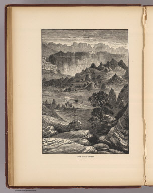
Author
Nichols, H. H.
Full Title
The Gray Cliffs. Nichols. (1895)
Publisher
Flood & Vincent
Full Title
Pink Cliffs, Paunsagunt Plateau. (1895)
Publisher
Flood & Vincent
Full Title
A Permian butte (Utah? 1895)
Publisher
Flood & Vincent
Full Title
Vermilion Cliffs at Kanab. (1895)
Publisher
Flood & Vincent
Full Title
A midsummerday's dream on the color (Utah? 1895)
Publisher
Flood & Vincent
Full Title
The Hurricane Fault. (1895)
Publisher
Flood & Vincent
Full Title
Towers of the Vermilion Cliffs. (1895)
Publisher
Flood & Vincent
Full Title
Temples and towers of the Rio Virgen. (1895)
Publisher
Flood & Vincent
Author
Moran, Thomas, 1837-1926
Full Title
The start from Green River Station. T(homas) M(oran. 1895)
Publisher
Flood & Vincent
Author
Nichols, H. H.
Full Title
Horseshoe Canyon. H.H. Nichols sc. (1895)
Publisher
Flood & Vincent
Full Title
Bird's-eye view of the Land of the Standing Rocks. (1895)
Publisher
Flood & Vincent
Full Title
Land of the Standing Rocks. (1895)
Publisher
Flood & Vincent
Author
Nichols, H. H.
Full Title
Recent lava flow on the Uinkaret. H.H. Nichols. (1895)
Publisher
Flood & Vincent
Author
Powell, John Wesley, 1834-1902.
Full Title
Sketch of Black Rock and vicinity, Utah Territory, Prepared to show the position of the graduated pillar erected by Dr. John Park for observation on the water-level of Great Salt Lake, and the position of the granite bench-mark. (to accompany) Report on the Lands of the Arid Region of the United States, with a More Detailed Account of the Lands of Utah. With Maps. By J.W. Powell. Second edition. Washington: Government Printing Office. 1879.
Publisher
Government Printing Office
Author
Powell, John Wesley, 1834-1902.
Full Title
Comparative map of Great Salt Lake, Utah : compiled to show its increase of area ... (to accompany) Report on the Lands of the Arid Region of the United States, with a More Detailed Account of the Lands of Utah. With Maps. By J.W. Powell. Second edition. Washington: Government Printing Office. 1879.
Publisher
Government Printing Office
|