Who What Where WhenREMOVEWHEREShow More |
Author
[Poirson, J.B., Herbin de Halle, Etienne de.]
Full Title
Carte d'Afrique ; Par J.B. Poirson, ingenieur géographe, en Nivose An VI, 1803. Grave par Tardieu l'aine, rue de Sorbonne, no. 385. (on upper right margin) No.XV. (to accompany) Statistique Generale et Particuliere De La France et De Ses Colonies, avec une Nouvelle Description ... 1804.
Publisher
F. Buisson
Author
[Poirson, J.B., Herbin de Halle, Etienne de.]
Full Title
Carte de la cote occidentale de l'Afrique, depuis le Cap Blanc jusquà la riv.re de Serra Leone ; comprenant le cours des riv.res du Senegal et de la Gambie ; par J. B. Poirson, ingenieur geographe ; grave par Tardieu l'aine rue de Sorbonne, no. 385. (on upper right margin) No.XVI. (to accompany) Statistique Generale et Particuliere De La France et De Ses Colonies, avec une Nouvelle Description ... 1804.
Publisher
F. Buisson
Author
[Poirson, J.B., Herbin de Halle, Etienne de.]
Full Title
Carte de la Inde, par J. B. Poirson, ingenieur geographe ; An XI (1803), grave par Tardieu l'aine rue de Sorbonne, no. 385. (on upper right margin) No.XVII. (to accompany) Statistique Generale et Particuliere De La France et De Ses Colonies, avec une Nouvelle Description ... 1804.
Publisher
F. Buisson
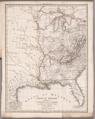
Author
[Poirson, J.B., Herbin de Halle, Etienne de.]
Full Title
Cours du Mississippi comprenant la Louisiane, les 2 Florides, une partie des Etats-Unis et pays adjacents. Par J. B. Poirson, ingenieur geographe ; Nivose An XI (1803), grave par Tardieu l'aine rue de Sorbonne, no. 385. (on upper right margin) No.XVIII. (to accompany) Statistique Generale et Particuliere De La France et De Ses Colonies, avec une Nouvelle Description ... 1804.
Publisher
F. Buisson
Author
Gilpin, William
Full Title
Map of the World. Delineating the Contrasted Longitudinal and Latitudinal forms of the continents: the Isothermal Zodiac and Axis of Intensity Round the World; and the Line of Cosmopolitan Railway and it Longitudinal Feeders. J.B. Lippincott & Co. Phila.
Publisher
J.B. Lippincott & Co.
Author
Gilpin, William
Full Title
Map of North America in which are delineated the Mountain System as a Unit, the Great Calcareous Plain and its Details, and the Continuous Encircling Maritime Selvage.
Publisher
J.B. Lippincott & Co.
Author
Gilpin, William
Full Title
Map of North America. Delineating the "Mountain System" and its details, The "Great Calcarious Plain" as a unit, and the continuous encircling "Maritime Selvage."
Publisher
J.B. Lippincott & Co.
Author
Gilpin, William
Full Title
Map Illustrating the System of the Parcs, and the Domestic Relations of the "Great Plains," the "North American Andes," and the Pacific Maritime Front."
Publisher
J.B. Lippincott & Co.
Author
Gilpin, William
Full Title
Map of Colorado Territory, and Northern Portion of New Mexico Showing the System of Parcs.
Publisher
J.B. Lippincott & Co.
Author
Gilpin, William
Full Title
Thermal Map of North America. Delineating the Isothermal Zodiac, the Isothermal Axis of Identity, and its expansions up and down the "Plateau."
Publisher
J.B. Lippincott & Co.
Author
[Bentley, Phyllis, Gill, Leslie MacDonald, 1884-1947]
Full Title
A Map of England Showing the Colne Valley Cloth District.
Publisher
The Huddersfield and District Woollen Export Group, Chamber of Commerce Huddersfield
Author
[Bentley, Phyllis, Gill, Leslie MacDonald, 1884-1947]
Full Title
A Map of the Colne Valley Cloth District.
Publisher
The Huddersfield and District Woollen Export Group, Chamber of Commerce Huddersfield
Author
[Bentley, Phyllis, Gill, Leslie MacDonald, 1884-1947]
Full Title
Colne Valley Home & Market.
Publisher
The Huddersfield and District Woollen Export Group, Chamber of Commerce Huddersfield
Author
[Bentley, Phyllis, Gill, Leslie MacDonald, 1884-1947]
Full Title
Geology of the Woollen District.
Publisher
The Huddersfield and District Woollen Export Group, Chamber of Commerce Huddersfield
Author
[Bentley, Phyllis, Gill, Leslie MacDonald, 1884-1947]
Full Title
Colne Valley Present Day.
Publisher
The Huddersfield and District Woollen Export Group, Chamber of Commerce Huddersfield
Author
Hutchins, Thomas
Full Title
A Plan of the Rapids, in the River Ohio, by Thos. Hutchins. J. Cheevers Sculpt.
Publisher
J. Almon
Author
Hutchins, Thomas
Full Title
A Plan of the several Villages in the Illinois Country, with Part of the River Mississippi &c. by Thos. Hutchins.
Publisher
J. Almon
Author
Tanner, Henry S.
Full Title
A Connected View of The Whole Internal Navigation of the United States; ... Corrected and Improved From the Edition of 1826, And Much Enlarged, ... With A Sheet Map, ... The Map Has Been Engraved For the Purpose ... On A Reduced Scale, From Tanner's Excellent Four Sheet Map of the United States, Recently Published. ... By a Citizen of the United States. Philadelphia: Published by the Author ... Printed by Lydia R. Bailey. 1830. (on verso) ...on the seventeenth day of April ... 1830, George Armroyd ... hath deposited ... a Book ... Pennsylvania.
Publisher
George Armroyd
Author
[Mitchell, John, Raynal, G.T., Zatta, Antonio]
Full Title
Le Isole Bermude. (title cartouche) Le Colonie Unite dell' America Settentrle. di Nuova Projezione Ass. Ee. Li Signori Riformatori dello Studio di Padova. Venezia 1778, Presso Antonio Zatta, con Privilegio dell' Eccellentissimo Senato.
Publisher
Antonio Zatta
Author
[Mitchell, John, Raynal, G.T., Zatta, Antonio]
Full Title
Il Canada, Le Colonie Inglesi Con La Luigiana, e Florida. di nuova Projezione. Venezia 1778. Presso Antonio Zatta Con Privilegio dell'Eccmo Senato. G. Zuliani inc.
Publisher
Antonio Zatta
Author
[Mitchell, John, Raynal, G.T., Zatta, Antonio]
Full Title
Il Paese de' Selvaggi Outauacesi, e Kilistinesi Intorno al Lago Superiore. (with) Supplemento alla Florida Orientale. Fogl. I.
Publisher
Antonio Zatta
Author
[Mitchell, John, Raynal, G.T., Zatta, Antonio]
Full Title
La Parte Occidentale della Nuova Francia o Canada. Fogl. II.
Publisher
Antonio Zatta
Author
[Mitchell, John, Raynal, G.T., Zatta, Antonio]
Full Title
Parte Orientale del Canada, Nuova Scozia Settentrionale, e Parte di Labrador. Fogl. III.
Publisher
Antonio Zatta
Author
[Mitchell, John, Raynal, G.T., Zatta, Antonio]
Full Title
Il Paese de' Selvaggi Outagamiani, Mascoutensi, Illinesi e Parte delle VI. Nazioni. Fogl. IV.
Publisher
Antonio Zatta
Author
[Mitchell, John, Raynal, G.T., Zatta, Antonio]
Full Title
La Pensilvania, la Nuova York, il Jersey Settentriole; con la Parte Occidentale del Connecticut, Massachussets Bay e l'Irochesia. Fogl. V.
Publisher
Antonio Zatta
Author
[Mitchell, John, Raynal, G.T., Zatta, Antonio]
Full Title
L'Acadia, le Provincie di Sagadahook e Main, la Nuova Hampshire, la Rhode Island, e parte di Massachusset e Connecticut. Fogl. VI.
Publisher
Antonio Zatta
Author
[Mitchell, John, Raynal, G.T., Zatta, Antonio]
Full Title
Il Paese de' Cherachesi, con la Parte Occidentale della Carolina Settentrionale, e della Virginia. Fogl. VII.
Publisher
Antonio Zatta
Author
[Mitchell, John, Raynal, G.T., Zatta, Antonio]
Full Title
Il Maryland, il Jersey Meridionale, la Delaware, e la Parte Orientale della Virginia, e Carolina Settentrionale. Fogl. VIII.
Publisher
Antonio Zatta
Author
[Mitchell, John, Raynal, G.T., Zatta, Antonio]
Full Title
La Giammaica. Fogl. IX.
Publisher
Antonio Zatta
Author
[Mitchell, John, Raynal, G.T., Zatta, Antonio]
Full Title
Luigiana Inglese, colla Parte Occidentale della Florida, della Giorgia, e Carolina Meridonale. Fogl. X.
Publisher
Antonio Zatta
Author
[Mitchell, John, Raynal, G.T., Zatta, Antonio]
Full Title
Parte Orientale della Florida, della Giorgia, e Carolina Meridionale. Fogl. XI.
Publisher
Antonio Zatta
Author
[Mitchell, John, Raynal, G.T., Zatta, Antonio]
Full Title
Le Isole di Terra Nuova e Capo Breton Di Nuova Projezione. Venezia 1778. Presso Antonio Zatta Con Privilegio del Eccmo Senato.
Publisher
Antonio Zatta
Author
[Mitchell, John, Raynal, G.T., Zatta, Antonio]
Full Title
La Baja D'Hudson Terra di Labrador e Groenlandia Con Le Isole Adiacenti di nuova Projezione. Venezia 1778, Presso Antonio Zatta Con Privilegio dell' Eccmo Senato. G. Giuliani inc. G. Pitteri scf.
Publisher
Antonio Zatta
Author
Morse, Jedidiah
Full Title
A Map of the States of Virginia, North Carolina, South Carolina and Georgia Comprehending the Spanish Provinces of East and West Florida Exhibiting the boundaries as fixed by the late Treaty of Peace between the United States and the Spanish Dominions. Compiled from late Surveys and Observations by Joseph Purcell. Engraved for Morse's Geography by Amos Doolittle at New Haven, 1788.
Publisher
Shepard Kollock
Author
Morse, Jedidiah
Full Title
A Map of the Northern and Middle States; Comprehending the Western Territory and the British Dominions in North America. Compiled from the best Authorities. Delineated & Engrav'd for Morse's Geography by Amos Doolittle, New Haven.
Publisher
Shepard Kollock
|