Who What Where WhenREMOVEWHO
|
Author
Chevalier, August
Full Title
The commercial, pictorial and tourist map of San Francisco, in colors and illustrated with litho-engraved pictures of all public buildings, parks, monuments, and recommended business houses, etc. Designed, engraved & copyrighted by Aug. Chevalier. Copyrighted 15th Dec. 1903 by Aug. Chevalier. 1st edition, 1904, August. Galloway Litho Co., S.F.
Publisher
Aug. Chevalier
Author
Clason Map Company
Full Title
Nevada And The Southeastern Portion Of California. Third Edition 1907. The Clason Map Company. Publishers Of Advertising And Reference Maps Denver, Colorado. Copyrighted 1906 And 1907 By Geo. S. Clason, Denver, Colorado.
Publisher
Clason Map Company
Author
Clason Map Company
Full Title
Clason's Guide Map Of The State Of Utah. Published By The Clason Map Co. Denver Colo. Copyrighted 1915, By The Clason Map Co. Denver, Colo. 1916 Edition.
Publisher
Clason Map Company
Author
Clason Map Company
Full Title
Clason's Guide Map Of New Mexico. Published By The Clason Map Co. Denver, Colorado. Copyrighted 1915 by The Clason Map Co. Denver, Colo. 1916 Edition.
Publisher
Clason Map Company
Author
Blanchard, Rufus
Full Title
Blanchard's Map Of The North Western States. Showing the Counties, Towns, Railroads, Stations, Steam Boat Landing etc. Compiled From The Most Authentic Sources. Published by Rufus Blanchard, 148 Lake Street, Chicago, Ill. 1868. Lith. Chas. Shober & Co. Chicago. Entered ... 1865, by R. Blanchard ... Illinois.
Publisher
Rufus Blanchard
Author
Clason Map Company
Full Title
Clason's Guide Map Of Wyoming. Published By The Clason Map Co. Denver, Colo. Copyrighted 1917 By The Clason Map Co. Denver, Colo.
Publisher
Clason Map Company
Author
Colton, J. H.
Full Title
Guide For The Territory Of Iowa, With A Correct Map, Showing the Township Surveys, &c. &c. New-York: Published By J.H. Colton 1840. (with) Map of the Surveyed part of Iowa. New York, Published by J.H. Colton, 1840. Engraved & Printed by Stiles, Sherman & Smith, N.Y. Entered ... 1839 by J.H. Colton ... N. York.
Publisher
J.H. Colton & Co.
Author
[Mitchell, Samuel Augustus, Drake, Ira S.]
Full Title
Mitchell's New Traveller's Guide Through The United States, Containing The Principal Cities, Towns &c. ... Illustrated By An Accurate Map Of The United States. Philadelphia: Thomas, Cowperthwait & Co. 1853. (on verso) Entered ... 1848, by Thomas, Cowperthwait & Co. ... Pennsylvania. Stereotyped by J. Fagan. Printed by Smith & Peters. (with map) Mitchell's New Traveller's Guide Through The United States, Showing the Rail Roads, Canals, Stage Roads &c. ... Drawn and Engraved by Ira S. Drake. Philadelphia 1854. Published by Thomas, Cowperthwait & Co. Entered ... 1848, by Thomas, Cowperthwait, & Co. ... Pennsylvania. (with 5 inset maps).
Publisher
Thomas, Cowperthwait & Co.
Author
[Mitchell, Samuel Augustus, Young, James H.]
Full Title
Mitchell's Traveller's Guide Through The United States. A Map Of The Roads, Distances, Steam Boat & Canal Routes &c. By J.H. Young. Philadelphia. Published by S. Augustus Mitchell. 1833. Engraved On Steel By J.H. Young And D. Haines. Entered ... 1832, by S. Augustus Mitchell ... Pennsylvania. (with 9 inset maps). (with folded sheet) Index. Steam-boat And Canal Routes ...
Publisher
S.Augustus Mitchell
Author
Kroll Map Company
Full Title
Kroll's Guide Map Of Puget Sound Country. Compiled & Published by Kroll Map Co. Mehlhorn Bldg. Seattle. (copyright) 1919. C. Kroll. Lithographed By Tucker, Hanford Co. Seattle.
Publisher
Kroll Map Company
Author
[Mitchell, Samuel Augustus, Young, James H.]
Full Title
Mitchell's Traveller's Guide Through The United States, Containing The Principal Cities, Towns, &c. ... Illustrated By An Accurate Map Of The United States. Philadelphia: Hinman & Dutton, No. 6 North Fifth Street. 1838. (on verso) Entered ... 1836, by Mitchell & Hinman ... Pennsylvania. Stereotyped by John Fagan ... Philadelphia. (with map) Mitchell's Travellers Guide Through The United States. A Map Of The Roads, Distances, Steam Boat & Canal Routes &c. By J.H. Young. Philadelphia. Published by S. Augustus Mitchell. 1838. Engraved On Steel By J.H. Young And D. Haines. Entered ... 1834 by S. Augustus Mitchell ... Pennsylvania. (with 9 inset maps).
Publisher
Mitchell & Hinman
Author
Colton, G. Woolworth
Full Title
G. Woolworth Colton's New Guide Map Of The United States & Canada, With Railroads, Counties, etc. Drawn, Engraved & Published by G. Woolworth Colton 18 Beekman St. New York, Rufus Blanchard, Chicago, Ill. 1862. Entered ... 1861 by G. Woolworth Colton ... New York. (inset) Western Portion Of The United States. (inset) Plan of The Southern Portion Of Florida.
Publisher
[G.Woolworth Colton, Rufus Blanchard]
Author
Tracy, J.L.
Full Title
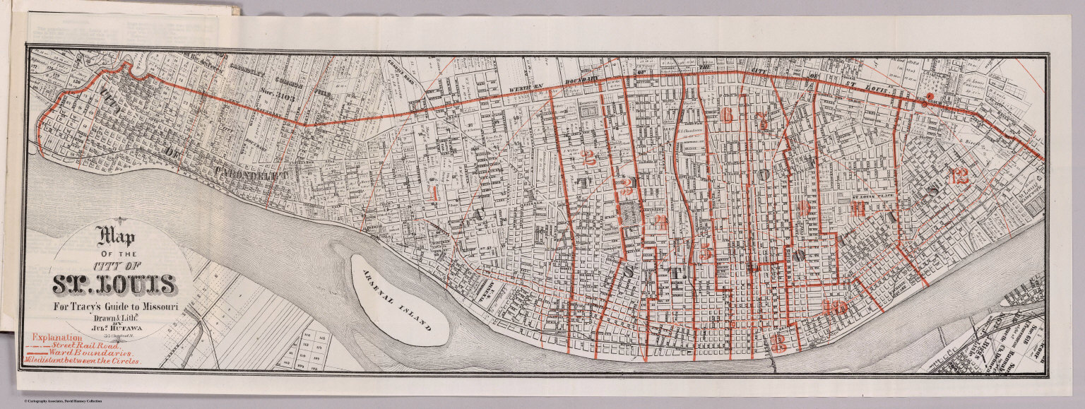
Map Of The State Of Missouri ... To illustrate Tracy's "Missouri Guide" and "Missouri Gazetteer" ... Published by The R.P. Studley Co. ... St. Louis 1871. Lith. by R.P. Studley & Co. St. Louis. (with) Map Of The City Of St. Louis For Tracy's Guide To Missouri. Drawn & Lithd. By Juls. Hutawa 313 Chestnut St. (with) Map Of The Missouri Pacific And Atlantic & Pacific Railroads, And Connections. National Railway Publication Co. Philadelphia.
Publisher
St. Louis:
Author
Tracy, J.L.
Full Title
Map Of The City Of St. Louis For Tracy's Guide To Missouri. Drawn & Lithd. By Juls. Hutawa 313 Chestnut St. (with) Map Of The State Of Missouri ... To illustrate Tracy's "Missouri Guide" and "Missouri Gazetteer" ... Published by The R.P. Studley Co. ... St. Louis 1871. Lith. by R.P. Studley & Co. St. Louis. (with) Map Of The Missouri Pacific And Atlantic & Pacific Railroads, And Connections. National Railway Publication Co. Philadelphia.
Publisher
St. Louis:
Author
Tracy, J.L.
Full Title
Map Of The Missouri Pacific And Atlantic & Pacific Railroads, And Connections. National Railway Publication Co. Philadelphia. (with) Map Of The City Of St. Louis For Tracy's Guide To Missouri. Drawn & Lithd. By Juls. Hutawa 313 Chestnut St. (with) Map Of The State Of Missouri ... To illustrate Tracy's "Missouri Guide" and "Missouri Gazetteer" ... Published by The R.P. Studley Co. ... St. Louis 1871. Lith. by R.P. Studley & Co. St. Louis.
Publisher
St. Louis:
Author
[Mitchell, Samuel Augustus, Young, James H.]
Full Title
Mitchell's Traveller's Guide Through The United States. A Map Of The Roads, Distances, Steam Boat & Canal Routes &c. By J.H. Young. Philadelphia. Published by S. Augustus Mitchell. 1835. Engraved On Steel By J.H. Young And D. Haines. Entered ... 1834 by S. Augustus Mitchell ... Pennsylvania. (with 9 inset maps). (with folded sheet) Index. Steam-boat And Canal Routes ...
Publisher
S.Augustus Mitchell
Author
Clason Map Company
Full Title
Clason's Map Of California Published By The Clason Map Co., Denver, Colo. Copyrighted 1910 By The Clason Map Co., Denver, Col. (inset) Enlarged Section Of San Francisco And Vicinity. (inset) Enlarged Section Of Los Angeles And Vicinity.
Publisher
Clason Map Company
Author
Mitchell, Samuel Augustus
Full Title
Mitchell's Traveller's Guide Through The United States, Containing The Principal Cities, Towns, &c.... Illustrated By An Accurate Map Of The United States. Philadelphia: Hinman & Dutton, No. 6 North Fifth Street. 1837. (on verso) Entered ... 1836, by Mitchell & Hinman ... Pennsylvania. Stereotyped by John Fagan ...Philadelphia. (with map) Mitchell's Travellers Guide Through The United States. A Map Of The Roads, Distances, Steam Boat & Canal Routes &c. By J.H. Young. Philadelphia. Published by S. Augustus Mitchell. 1838. Engraved On Steel By J.H. Young And D. Haines. Entered ... 1834 by S. Augustus Mitchell ... Pennsylvania. (with 9 inset maps).
Publisher
Mitchell & Hinman
Author
Mitchell, Samuel Augustus
Full Title
Mitchell's Map Of The United States Showing the Principal Travelling, Turnpike and Common Roads ... Philadelphia: Published By S. Augustus Mitchell. 1838. Sold by Mitchell & Hinman. No. 6 North Fifth Street. Entered ... 1835, by S. Augustus Mitchell... Pennsylvania. (with 8 inset maps. (with) Mitchell's Compendium Of The Internal Improvements Of The United States; Comprising General Notices Of All The Most Important Canals and Rail-Roads... Philadelphia: Published By Mitchell & Hinman, No. 6, North-Fifth Street. 1838. (on verso) Entered ... 1835, by Mitchell & Hinman ... Pennsylvania. Stereotyped by John Fagan ... Philadelphia.
Publisher
Mitchell and Hinman
Author
Scott, Samuel
Full Title
Map Of The Black Hills Of South Dakota And Wyoming With Full Descriptions Of Mineral Resources, Etc. By Samuel Scott, M.E. Custer City, S.D. 1897 ... (on verso) Copyrighted 1896 By Samuel Scott, M.E. E.P. Noll & Co. Map Publishers No. 9 N. Sixth St., Philadelphia, Pa. (with) Map Of The Black Hills Of South Dakota & Wyoming. 1897. By Samuel Scott Mining Engineer, Custer, S.D. Copyrighted 1896, by Samuel Scott, M.E. (untitled inset map of the Deadwood vicinity).
Publisher
E.P. Noll
Author
[Mitchell, Samuel Augustus, Young, James H.]
Full Title
Mitchell's Traveller's Guide Through The United States. A Map Of The Roads, Distances, Steam Boat & Canal Routes &c. By J.H. Young. Philadelphia. Published by S. Augustus Mitchell. 1834. Engraved On Steel By J.H. Young And D. Haines. Entered ... 1834 by S. Augustus Mitchell ... Pennsylvania. (with 9 inset maps). (with folded sheet) Index. Steam-boat And Canal Routes ...
Publisher
S.Augustus Mitchell
Author
[Mitchell, Samuel Augustus, Young, James H.]
Full Title
Mitchell's Traveller's Guide Through The United States, Containing The Principal Cities, Towns, &c. ... Illustrated By An Accurate Map Of The United States. Philadelphia: Thomas, Cowperthwait, & Co. 253 Market Street. (on verso) Entered ... 1836, by Mitchell & Hinman ... Pennsylvania. Stereotyped by John Fagan ... Philadelphia. (with map) Mitchell's Travellers Guide Through The United States. A Map Of The Roads, Distances, Steam Boat & Canal Routes &c. By J.H. Young. Philadelphia. Published by S. Augustus Mitchell. 1845. Engraved On Steel By J.H. Young And D. Haines. Entered ... 1834 by S. Augustus Mitchell ... Pennsylvania. (with 8 inset maps).
Publisher
Thomas, Cowperthwait & Co.
Author
[Mitchell, Samuel Augustus, Young, James H., Drake, Ira S., Hazzard, John L.]
Full Title
A New Map Of The United States of America. By J.H. Young. Philadelphia. (with 2 inset maps) Gold Regions of California and District of Columbia. Published by Charles Desilver, No. 253 Market St.
Publisher
Charles Desilver
Author
[Mitchell, Samuel Augustus, Young, James H., Drake, Ira S., Hazzard, John L.]
Full Title
Mitchell's New Traveller's Guide Through The United States, Showing the Rail Roads, Canals, Stage Roads &c. With Distances from Place to Place. Drawn and Engraved by I.S. Drake & J.L. Hazzard. Philadelphia 1856. (with 5 inset maps) Map of New England or Eastern States; Map of Maritime and Overland Routes to California; Map of the Gold and Quicksilver District of California; Map of Coper Mine Region; Vicinity of Niagara Falls. Published by Charles Desilver, No. 253 Market St. Entered ... 1856 by Charles Desilver... Pennsylvania.
Publisher
Charles Desilver
Author
Tanner, Henry S. Jun'r.
Full Title
Philadelphia 1840. Published by H.S. Tanner, Phiadelphia. Entered .. 1836 by Henry S. Tanner ... Pennsylvania. (above neat line) Tanner's Universal Atlas. (with) A New Guide To The Public Buildings ... Of The City of Philadelphia, And Adjoining Districts: With A Brief Description And A Plan Of The City And Environs. Philadelphia: H. Tanner, Jun'r. No. 32 South Sixth Street. 1840. (on verso) Entered ... 1840, By H. Tanner, Jr. ... Pennsylvania. Philadelphia 1840. Published by H.S. Tanner, Phiadelphia.
Publisher
H. Tanner, Jun'r.
Author
[Disturnell, John, Smith, J. Calvin, Tanner, T.R.]
Full Title
New Map of the City Of New York, With Brooklyn & Parts Of Williamsburgh; By J. Calvin Smith. Engraved on steel by Stiles, Sherman & Smith. Published By Tanner & Disturnell. No. 124 Broadway. 1840. Entered ... 1839 by J. Disturnell ... New York. (with) A Guide To The City Of New-York; Containing An Alphabetical List Of Streets, &c. Accompanied By A New And Correct Map. New-York: Published By Tanner & Disturnell. 1840. (on verso) Entered ... 1839, by Tanner & Disturnell ... New-York. Sackett & Sargent, Printers, No. 1 Nassau-street, corner of Wall.
Publisher
Tanner & Disturnell
Author
Tanner, Henry S.
Full Title
A Map Of The Canals & Rail Roads Of Pennsylvania And New Jersey And The Adjoining States. By H.S. Tanner. Published by H.S. Tanner ... Entered ... 1833, by H.S. Tanner ... Pennsylvania. Engraved by H.S. Tanner & Assistants. (with) A Brief Description Of The Canals And Rail Roads Of Pennsylvania And New Jersey, Comprehending Notices Of All The Most Important Works Of Internal Improvements, In Those States. By H.S. Tanner. Philadelphia: Published By The Author, November, 1834. (on verso) Entered ... 1834, by H.S. Tanner ... Pennsylvania. Joseph & William Kite, Printers.
Publisher
H.S. Tanner
Author
Rand McNally and Company
Full Title
Rand McNally & Co's Historical Description And Guide Map Of Chicago ... Chicago: Rand, McNally & Co., Printers And Engravers, 77 and 79 Madison Street. (on verso) Entered ... 1879, by Rand, McNally & Co. ... Washington. (with) Map Showing The Boulevards And Park System And Twelve Miles of Lake Frontage Of The City Of Chicago. Engraved By Rand, McNally & Co. ... Entered ... 1879, by Rand, McNally & Co. ... Washington, D.C. ...
Publisher
Rand McNally & Co.
Author
Rand McNally and Company
Full Title
Map Showing The Boulevards And Park System And Twelve Miles of Lake Frontage Of The City Of Chicago. Engraved By Rand, McNally & Co. ... Entered ... 1879, by Rand, McNally & Co. ... Washington, D.C. ... (with) Rand McNally & Co's Historical Description And Guide Map Of Chicago ... Chicago: Rand, McNally & Co., Printers And Engravers, 77 and 79 Madison Street. (on verso) Entered ... 1879, by Rand, McNally & Co. ... Washington.
Publisher
Rand McNally & Co.
Author
Rand McNally and Company
Full Title
Rand, McNally & Co's Guide Map To The Business District Of Chicago. (with 38 page index) Rand, McNally & Co.'s Guide Map Of Chicago ... With A Complete Street And Avenue Guide To the Entire City. Chicago: Rand, McNally & Co., Printers And Engravers, 79 and 81 Madison Street, 1875. (on verso) Entered ... 1875, by Rand, McNally & Co. ... Washington.
Publisher
Rand McNally & Co.
Author
[Mitchell, Samuel Augustus, Young, James H.]
Full Title
Mitchell's Travellers Guide Through The United States. A Map Of The Roads, Distances, Steam Boat & Canal Routes &c. By J.H. Young. Philadelphia. Published by S. Augustus Mitchell. 1843. Engraved On Steel By J.H. Young And D. Haines. Entered ... 1834 by S. Augustus Mitchell ... Pennsylvania. (with 8 inset maps).
Publisher
Thomas, Cowperthwait & Co.
Author
Williams, C.S.
Full Title
Williams' Travellers' Directory, And Map Of the United States. Sold by S. Babcock & Co. Charleston, S.C. (with) Map Of The United States Constructed From the latest Authorities. Published by C.S. Williams, New Haven 1833. (with folded sheet) Traveler's Directory, And Statistical View Of The United States. Published By C.S. Williams, New-Haven, 1833.
Publisher
C.S. Williams
Author
[Disturnell, John, Eddy, J.H.]
Full Title
Map of the Country Thirty Miles round the City of New York. New Edition, 1839. New-York, Published by J. Disturnell. Drawn by I.H. Eddy. (with) A Description Of The Cities, Townships, And Principal Villages And Settlements, Within Thirty Miles Of The City Of New-York ... Accompanied By A Correct Map. New-York: Published By Colton & Disturnell, No. 14 Broadway. M DCCC XXXIX. (on verso) Entered ...1839, by John Disturnell ... New-York. Sackett & Sargent, Printers, No. 1 Nassau street, cor. of Wall.
Publisher
Colton & Disturnell
Author
Phelps & Ensign
Full Title
Phelps & Ensign's Traveller's Guide Through the United States ... Illustrated By A New And Accurate Map Of The United States. New York: Phelps & Ensign, No. 7 Bowery. 1845. Entered .. 1838, by Phelps & Ensign .. New York. (with) Phelps & Ensign's Travellers' Guide, and Map of the United States ... New York, Published by T & E.H. Ensign, 1845. Engraved on Steel by J.Wells, Brooklyn L.I. Entered ... 1837 by Phelps & Squire ... New York. (with 16 inset maps).
Publisher
Phelps & Ensign
Author
Phelps & Ensign
Full Title
Phelps & Ensign's Traveller's Guide Through the United States ... Illustrated By A New And Accurate Map Of The United States. New York: Phelps & Ensign, No. 7 Bowery. 1843. Entered .. 1838, by Phelps & Ensign .. New York. (with) Phelps & Ensign's Travellers' Guide, and Map of the United States ... New York, Published by T & E.H. Ensign, 1843. Engraved on Steel by J.Wells, Brooklyn L.I. Entered ... 1837 by Phelps & Squire ... New York. (with 16 inset maps).
Publisher
Phelps & Ensign
Author
[Ensigns & Thayer, Phelps, Humphrey]
Full Title
Phelps's Travellers' Guide Through The United States ... Accompanied With A New Map Of The United States. New-York: Published By Ensigns & Thayer, 50 Ann-Street. 1849. (with) Phelps's National Map Of The United States, A Travellers Guide ... New York, Published By Ensign & Thayer ... 1849. Drawn & Engraved by J.M. Atwood, N.Y. Entered ... 1849, by Ensign & Thayer ... New York. (with 3 inset maps).
Publisher
Ensigns & Thayer
Author
Phelps & Ensign
Full Title
Phelps & Ensign's Traveller's Guide Through the United States ... Illustrated By A New And Accurate Map Of The United States. New York: Phelps & Ensign, No. 7 Bowery. 1839. Entered .. 1838, by Phelps & Ensign .. New York. (with) Phelps & Ensign's Travellers' Guide, and Map of the United States ... New York, Published by Phelps & Ensign, 1839. Engraved on Steel by J.Wells, Brooklyn L.I. Entered ... 1837 by Phelps & Squire ... New York. (with 16 inset maps).
Publisher
Phelps & Ensign
Author
Davison, G.M.
Full Title
Routes And Tables Of Distances Embraced In The Traveller's Guide Through The Northern And Middle States And The Canadas. Saratoga Springs: Published By G.M. Davison. 1833. (with) Map Of The Routes Through The Middle & Northern States And The Provinces Of Canada Designed to Accompany The Travelers Guide. Published by G.M. Davidson (sic) Saratoga Springs 1833. Drawn by O.H. Lee.
Publisher
G.M. Davison
Author
E.P. Noll & Co.
Full Title
Noll's New Official Guide Map Of Philadelphia From The Latest Official Surveys & Records ... 1890. Published By E.P. Noll & Co. Map Publishers & Mounters 17 North Sixth Street Philadelphia, Pa. Entered ... 1889, by E.P Noll & Co. ... Washington D.C.
Publisher
E.P. Noll & Co.
Author
Blanchard, Rufus
Full Title
Blanchard's Map Of Iowa And Nebraska Showing The Counties Towns & Rail Roads. Published by Rufus Blanchard, Chicago. 1867. Lith Chas Shober, Chicago.
Publisher
Rufus Blanchard
Author
McDonald, R.H.
Full Title
R. H. McDonald's Map Of Chicago, with a correct outline of the Great Fire, from a careful survey by Sharp & Thain, of Chicago. New York: R. B. Thompson & Co., 755 Broadway. 1871. (with) R. H. McDonald's Illustrated History and Map Of Chicago, With A History Of The Great Fire; Containing Views of Chicago in 1820 and 1871. Photographs of the Public Buildings Burned. Growth and Progress of Chicago from 1774 to 1871. Its Trade, Commerce, Industry, and Enterprise, with A Record Of All The Great Fires of the World. The map is from an official survey of the city as it was, with a careful and correct outline of the burned district. New York: R. B. Thompson & Co., 755 Broadway. 1872. Entered ... 1871, by R.H. McDonald & R.B. Thompson ... Washington.
Publisher
R. B. Thompson & Co.
Author
Campbell, R.A.
Full Title
Campbell's Revised Guide Map of St. Louis Copyright 1882 by R.A. Campbell Publisher S.E. Cor. Olive and Fifth Sts. St. Louis. (with inset map of the City north of Calvery Cemetery)
Publisher
R. A. Campbell
Author
Hall, John D.
Full Title
How To Get There In New York City. ... Copyright, 1894, by John D. Hall. Published Only By The Hall Publishing Co., No. 6 East 42nd Street, New York. 1894. Third 10,000 Edition. (with map) How To Get There. Sectional And Ward Map Of New York City. Hall Publishing Co. 42nd St., New York. Copyright, 1893. By John D. Hall. E.F. Fisk, Engr., N.Y. (inset) Hunts Point.
Publisher
The Hall Publishing Company
Author
Asher & Adams
Full Title
Asher & Adams' New Commercial And Topographical Rail-Road Map And Guide Of North Carolina And South Carolina. Comprising A New Map, Colored By Counties, On A Scale Of Twenty Miles To An Inch; Delineating Rivers, Landings, Railroads, Stations with Distances, Etc. ... New York: American Rail Road Map And Guide Publishing Company, 39 Beekman Street. Entered... in the year one thousand eight hundred and seventy-four, by Asher & Adams ... Washington. (with map) Asher & Adams' North Carolina And South Carolina. Entered ... 1874 by Asher & Adams ... Washington.
Publisher
American Rail Road Map And Guide Publishing Company
Author
Hewett, Daniel
Full Title
The Traveller's Guide Through The United States, And Brief Geographical View Of The World ... Being the Outlines of a Course of Lectures on Geography. By D. Hewett, A.M. New York Published for the Author, at No. 73 Vesey Street, March, 1822. (with map) United States. J.D. Stout. (with folded sheet) General View Of The World. Arranged according to the course of Geographical Lectures by D. Hewett.
Publisher
D. Hewett
Author
Phelps & Ensign
Full Title
Phelps & Ensign's Traveller's Guide Through the United States ... Illustrated By A New And Accurate Map Of The United States. New York: Phelps & Ensign, No. 7 Bowery. 1838. Entered .. 1838, by Phelps & Ensign .. New York. (with) Phelps & Ensign's Travellers' Guide, and Map of the United States ... New York, Published by Phelps & Ensign, 1838. Engraved on Steel by J.Wells, Brooklyn L.I. Entered ... 1837 by Phelps & Squire ... New York. (with 16 inset maps).
Publisher
Phelps & Ensign
Author
[Atwood, J.M., Ensign, Bridgman & Fanning]
Full Title
Ensign, Bridgman & Fanning's Traveller's Guide Through The States Of Ohio, Michigan, Indiana, Illinois, Missouri, Iowa, And Wisconsin ... Accompanied With A New Map Of The Above States. New York: Ensign, Bridgman & Fanning, 156 William Street, Corner Of Ann, 1856. (on verso) Entered ... 1855, by Ensign, Bridgman & Fanning ... New York. (with) Map Of The Western States By J.M. Atwood. Published By Ensign, Bridgman & Fanning ... 1855. Entered ... 1848 by Ensign's & Thayer ... New York.
Publisher
Ensign, Bridgman & Fanning
Author
Blanchard, Rufus
Full Title
Blanchard's Map Of Minnesota And Dakota Showing The Counties, Towns & Rail Roads. 1867. Published by Rufus Blanchard Chicago, Ill.
Publisher
Blanchard & Cram.
Author
Vandewater, Robert J.
Full Title
An Improved Map of the Hudson River, with the Post Roads between N. York & Albany. Published by S. Mahon & Co. Drawn & Engraved Expressly For The Tourist. 1830. W. Chapin Sc. (with) The Tourist, Or Pocket Manual For Travellers On The Hudson River, The Western Canal, And Stage Road ... New-York: Printed By J. & J. Harper, No. 82 Cliff-street. 1830.
Publisher
J. & J. Harper
Author
Boardman, Harvey
Full Title
Map Of The White Mountains New Hampshire From Original Surveys by Harvey Boardman, Griswold, Conn. 1858. Engraved by Smith, Knight & Tappan, Boston. Entered ... 1858, by Harvey Boardman ... Massachusetts. (with) Railway Map Of Routes To The White Mountains By Harvey Boardman, Griswold, Ct. Entered ... 1859, by Harvey Boardman ... Massachusetts. J.H. Bufford's Lith. 313 Washn. St. Boston.
Publisher
Crosby, Nichols, & Co.
|