Who What Where WhenREMOVE |
Author
Spruner von Merz, Karl
Full Title
(Introduction to) Historisch-geographischer Hand-Atlas zur Geschichte der Staaten Europa's vom Anfang des Mittelalters bis auf die neueste Zeit von Dr. Karl von Spruner ... Drei und Seibzig colorirte Karten nebst erlauternden Vorbemerkungen. Zweite Auflage. Gotha: bei Justhus Perthes. 1854(-1863)
Publisher
Justus Perthes
Author
Spruner von Merz, Karl
Full Title
(Title Page to) Historisch-geographischer Hand-Atlas zur Geschichte der Staaten Europa's vom Anfang des Mittelalters bis auf die neueste Zeit von Dr. Karl von Spruner ... Drei und Seibzig colorirte Karten nebst erlauternden Vorbemerkungen. Zweite Auflage. Gotha: bei Justhus Perthes. 1854(-1863)
Publisher
Justus Perthes
Author
Spruner von Merz, Karl
Full Title
(Inside Cover to) Historisch-geographischer Hand-Atlas zur Geschichte der Staaten Europa's vom Anfang des Mittelalters bis auf die neueste Zeit von Dr. Karl von Spruner ... Drei und Seibzig colorirte Karten nebst erlauternden Vorbemerkungen. Zweite Auflage. Gotha: bei Justhus Perthes. 1854(-1863)
Publisher
Justus Perthes
Author
Willard, Emma
Full Title
(Covers to) Atlas to accompany a System of universal history; containing: I. A chronological picture of nations, or perspective sketch of the course of empire. II. The progressive geography of the World, in a series of maps, adapted to the different epochas of the history. By Emma Willard, Principal of Troy Female Seminary, and author of other geographical and historical works. Hartford: Published By F.J. Huntington. MDCCCXXXVI. Entered ... 1835, by F.J. Huntington ... Connecticut.
Publisher
F.J. Huntington
Author
Willard, Emma
Full Title
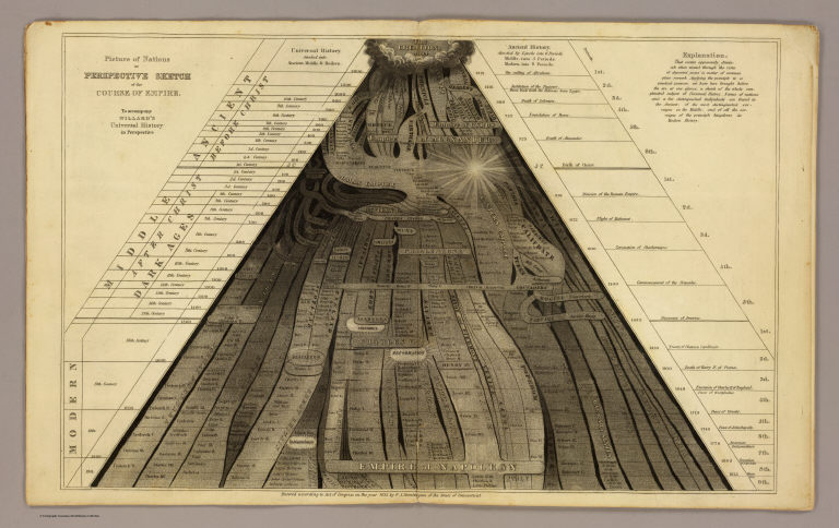
Picture of nations or perspective sketch of the course of empire. To accompany Willard's Universal history in perspective. Entered ... 1835, by F.J. Huntington ... Connecticut. (1836)
Publisher
F.J. Huntington
Full Title
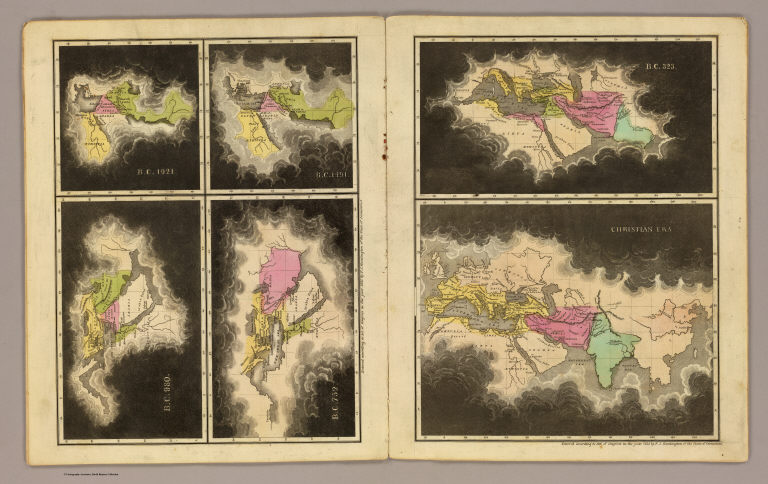
B.C. 1921. B.C. 1491. B.C. 980. B.C. 752. B.C. 323. Christian era. Entered ... 1835, by F.J. Huntington ... Connecticut. (1836)
Publisher
F.J. Huntington
Full Title
A.D. 395. A.D. 1100. A.D. 1492. Entered ... 1835, by F.J. Huntington ... Connecticut. (1836)
Publisher
F.J. Huntington
Author
[Paullin, Charles O., Wright, John K.]
Full Title
(Covers to) Atlas of the Historical Geography of the United States. By Charles O. Paullin, Carnegie Institution of Washington. Edited by John K. Wright, Librarian, American Geographical Society of New York. Published Jointly by Carnegie Institution of Washington and the American Geographical Society of New York, 1932.
Publisher
[Carnegie Institution of Washington, American Geographical Society of New York]
Author
[Paullin, Charles O., Wright, John K.]
Full Title
(Title Page) Atlas of the Historical Geography of the United States. By Charles O. Paullin, Carnegie Institution of Washington. Edited by John K. Wright, Librarian, American Geographical Society of New York. Published Jointly by Carnegie Institution of Washington and the American Geographical Society of New York, 1932.
Publisher
[Carnegie Institution of Washington, American Geographical Society of New York]
Author
[Paullin, Charles O., Wright, John K.]
Full Title
(Composite Text of) (Preface, Introduction, Main Text).
Publisher
[Carnegie Institution of Washington, American Geographical Society of New York]
Author
[Paullin, Charles O., Wright, John K.]
Full Title
Plate 1. Natural Environment: Natural Regions, Glaciated Areas, Ocean Currents. Major Geographical Regions. Cultivated Crops. Winds and Sailing Routes - Winter. Winds and Sailing Routes - Summer.
Publisher
[Carnegie Institution of Washington, American Geographical Society of New York]
Author
[Paullin, Charles O., Wright, John K.]
Full Title
Plate 2. Physical Geography and Vegetation. Relief; Soil Regions. Physical Divisions. Vegetation Regions.
Publisher
[Carnegie Institution of Washington, American Geographical Society of New York]
Author
[Paullin, Charles O., Wright, John K.]
Full Title
Plate 3. Forests; Growing Season. Area of Virgin Forest 1620. Area of Virgin Forest 1850. Area of Virgin Forest 1926. National Forest 1930. Average Length of Growing Season.
Publisher
[Carnegie Institution of Washington, American Geographical Society of New York]
Author
[Paullin, Charles O., Wright, John K.]
Full Title
Plate 4. Climate. Snow Cover. Droughts. Relative Humidity. Cloudiness. Pressure.
Publisher
[Carnegie Institution of Washington, American Geographical Society of New York]
Author
[Paullin, Charles O., Wright, John K.]
Full Title
Plate 5. Climate. Temperature. Rainfall.
Publisher
[Carnegie Institution of Washington, American Geographical Society of New York]
Author
[Paullin, Charles O., Wright, John K.]
Full Title
Plate 6. Mineral Resources. Coal Fields, Distribution and Production of Iron Ore.
Publisher
[Carnegie Institution of Washington, American Geographical Society of New York]
Author
[Paullin, Charles O., Wright, John K.]
Full Title
Plate 7. Mineral Resources. Oil and Gas Fields. Gold, Silver, and Copper Districts.
Publisher
[Carnegie Institution of Washington, American Geographical Society of New York]
Author
[Paullin, Charles O., Wright, John K.]
Full Title
Plate 8. Cartography 1492-1867. Behaim Globe Gores, 1492. (Facsimile).
Publisher
[Carnegie Institution of Washington, American Geographical Society of New York]
Author
[Paullin, Charles O., Wright, John K.]
Full Title
Plate 9. Cartography 1492-1867. Cantino Map, ca. 1502. (Facsimile).
Publisher
[Carnegie Institution of Washington, American Geographical Society of New York]
Author
[Paullin, Charles O., Wright, John K.]
Full Title
Plate 10. Cartography 1492-1867. La Cosa Map, 1500. (Facsimile).
Publisher
[Carnegie Institution of Washington, American Geographical Society of New York]
Author
[Paullin, Charles O., Wright, John K.]
Full Title
Plate 11. Cartography 1492-1867. Magiolo Map ca. 1519. Ortelius Map, 1589. (Facsimiles).
Publisher
[Carnegie Institution of Washington, American Geographical Society of New York]
Author
[Paullin, Charles O., Wright, John K.]
Full Title
Plate 12. Cartography 1492-1867. De Soto Map ca. 1544. Gastaldi Map, 1546. (Facsimiles).
Publisher
[Carnegie Institution of Washington, American Geographical Society of New York]
Author
[Paullin, Charles O., Wright, John K.]
Full Title
Plate 13. Cartography 1492-1867. Verrazano Map, 1529. (Facsimile).
Publisher
[Carnegie Institution of Washington, American Geographical Society of New York]
Author
[Paullin, Charles O., Wright, John K.]
Full Title
Plate 14. Cartography 1492-1867. Harleian Map ca. 1536. (Facsimile).
Publisher
[Carnegie Institution of Washington, American Geographical Society of New York]
Author
[Paullin, Charles O., Wright, John K.]
Full Title
Plate 15. Cartography 1492-1867. Mercator Map, 1569. (Facsimile).
Publisher
[Carnegie Institution of Washington, American Geographical Society of New York]
Author
[Paullin, Charles O., Wright, John K.]
Full Title
Plate 16. Cartography 1492-1867. Lemoyne Map, 1591. (Facsimile).
Publisher
[Carnegie Institution of Washington, American Geographical Society of New York]
|