|
Author
[Paullin, Charles O., Wright, John K.]
Full Title
Plate 56. Lands. A Western Town: Carroll, Nebraska, 1918. A Western Township Pilot Knob, Harper County, Kansas, 1919. Specimen Private Land Claims, 1835. Federal Land Grants for the Construction of Railroads and Wagon Roads, 1823-1871. Oil Land Withdrawals in California, 1915 (Facsimiles).
Publisher
[Carnegie Institution of Washington, American Geographical Society of New York]
Author
[Paullin, Charles O., Wright, John K.]
Full Title
Plate 57. Public Lands. Public Lands of United States, 1790. Public Lands of United States, 1810.
Publisher
[Carnegie Institution of Washington, American Geographical Society of New York]
Author
[Paullin, Charles O., Wright, John K.]
Full Title
Plate 58. Public Lands. Public Lands of United States, 1830. Public Lands of United States, 1850. Public Lands of United States, 1870. Public Lands of United States, 1890.
Publisher
[Carnegie Institution of Washington, American Geographical Society of New York]
Author
[Paullin, Charles O., Wright, John K.]
Full Title
Plate 59. Public Lands. Public Lands of United States, 1910. Distribution of Public Lands of United States, 1929.
Publisher
[Carnegie Institution of Washington, American Geographical Society of New York]
Author
[Paullin, Charles O., Wright, John K.]
Full Title
Plate 60. Settlement and Population, 1660-1790. Settled Areas and Population, 1660. Settled Areas and Population, 1770. Settled Areas, 1760, and Population, 1750. Settled Areas and Population, 1775. Settled Areas and Population, 1790.
Publisher
[Carnegie Institution of Washington, American Geographical Society of New York]
Author
[Paullin, Charles O., Wright, John K.]
Full Title
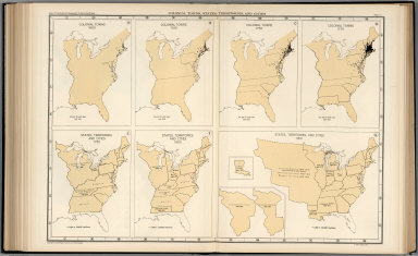
Plate 61. Colonial Towns, States, Territories, and Cities. Colonial Towns, 1650. Colonial Towns, 1700. Colonial Towns, 1750. Colonial Towns, 1775. States, Territories and Cities, 1790. States, Territories and Cities, 1800. States, Territories and Cities, 1810.
Publisher
[Carnegie Institution of Washington, American Geographical Society of New York]
Author
[Paullin, Charles O., Wright, John K.]
Full Title
Plate 62. States, Territories and Cities. States, Territories and Cities, 1820. States, Territories and Cities, 1830.
Publisher
[Carnegie Institution of Washington, American Geographical Society of New York]
Author
[Paullin, Charles O., Wright, John K.]
Full Title
Plate 63. States, Territories and Cities. States, Territories and Cities, 1840. States, Territories and Cities, 1850.
Publisher
[Carnegie Institution of Washington, American Geographical Society of New York]
Author
[Paullin, Charles O., Wright, John K.]
Full Title
Plate 64. States, Territories and Cities. States, Territories and Cities, 1860. States, Territories and Cities, 1870. States and Territories (Additional Maps 1845-1868). States, Territories and Cities, 1880.
Publisher
[Carnegie Institution of Washington, American Geographical Society of New York]
Author
[Paullin, Charles O., Wright, John K.]
Full Title
Plate 65. States, Territories and Cities. States, Territories and Cities, 1890. States, Territories and Cities, 1900.
Publisher
[Carnegie Institution of Washington, American Geographical Society of New York]
Author
[Paullin, Charles O., Wright, John K.]
Full Title
Plate 66. States, Territories and Cities. States, Territories and Cities, 1910. States, Territories and Cities, 1920.
Publisher
[Carnegie Institution of Washington, American Geographical Society of New York]
Author
[Paullin, Charles O., Wright, John K.]
Full Title
Plate 67. States and Cities: Population. States and Cities, 1930. Slaves, 1790. Slaves, 1800. Slaves, 1810. Slaves, 1820. Slaves, 1830. Slaves, 1840.
Publisher
[Carnegie Institution of Washington, American Geographical Society of New York]
Author
[Paullin, Charles O., Wright, John K.]
Full Title
Plate 68. Population. Slaves, 1850. Slaves, 1860. Free Negroes, 1810.
Publisher
[Carnegie Institution of Washington, American Geographical Society of New York]
Author
[Paullin, Charles O., Wright, John K.]
Full Title
Plate 69. Population. Free Negroes, 1860. Colored Population, 1880.
Publisher
[Carnegie Institution of Washington, American Geographical Society of New York]
Author
[Paullin, Charles O., Wright, John K.]
Full Title
Plate 70. Population: Emigration to the United States. Colored Population, 1900. Colored Population, 1930. Sources of Emigration to the United States (by decade),
Publisher
[Carnegie Institution of Washington, American Geographical Society of New York]
Author
[Paullin, Charles O., Wright, John K.]
Full Title
Plate 71. Population. Foreign-Born Population, 1860. Foreign-Born Population, 1880.
Publisher
[Carnegie Institution of Washington, American Geographical Society of New York]
Author
[Paullin, Charles O., Wright, John K.]
Full Title
Plate 72. Population. Foreign-Born Population, 1900. Foreign-Born White Population, 1930.
Publisher
[Carnegie Institution of Washington, American Geographical Society of New York]
Author
[Paullin, Charles O., Wright, John K.]
Full Title
Plate 73. Population. Foreign-Born Population, German, 1880. Foreign-Born Population, German, 1900. Foreign-Born Population, German, 1930. Foreign-Born Population, Irish, 1880.
Publisher
[Carnegie Institution of Washington, American Geographical Society of New York]
Author
[Paullin, Charles O., Wright, John K.]
Full Title
Plate 74. Population. Foreign-Born Population, Irish, 1900. Foreign-Born Population, Irish, 1930.
Publisher
[Carnegie Institution of Washington, American Geographical Society of New York]
Author
[Paullin, Charles O., Wright, John K.]
Full Title
Plate 75. Population. Foreign-Born Population, Swedish and Norwegian, 1880. Foreign-Born Population, Swedish and Norwegian, 1900.
Publisher
[Carnegie Institution of Washington, American Geographical Society of New York]
Author
[Paullin, Charles O., Wright, John K.]
Full Title
Plate 76. Population. Foreign-Born Population, Swedish and Norwegian, 1790. Density of Population, 1800. Density of Population, 1810. Density of Population, 1820. Density of Population, 1830. Density of Population, 1840.
Publisher
[Carnegie Institution of Washington, American Geographical Society of New York]
Author
[Paullin, Charles O., Wright, John K.]
Full Title
Plate 77. Population. Density of Population, 1850. Density of Population, 1860. Density of Population, 1870.
Publisher
[Carnegie Institution of Washington, American Geographical Society of New York]
Author
[Paullin, Charles O., Wright, John K.]
Full Title
Plate 78. Population. Density of Population, 1880. Density of Population, 1890.
Publisher
[Carnegie Institution of Washington, American Geographical Society of New York]
Author
[Paullin, Charles O., Wright, John K.]
Full Title
Plate 79. Density of Population. Density of Population, 1900. Density of Population, 1910. Density of Population, 1920. Density of Population, 1930.
Publisher
[Carnegie Institution of Washington, American Geographical Society of New York]
Author
[Paullin, Charles O., Wright, John K.]
Full Title
Plate 80. Population: Colleges and Universities. Centers of Population. Colleges and Universities, 1775. Colleges and Universities, 1800. Colleges and Universities, 1830.
Publisher
[Carnegie Institution of Washington, American Geographical Society of New York]
Author
[Paullin, Charles O., Wright, John K.]
Full Title
Plate 81. Colleges and Universities. Colleges and Universities, 1860. Colleges and Universities, 1890.
Publisher
[Carnegie Institution of Washington, American Geographical Society of New York]
Author
[Paullin, Charles O., Wright, John K.]
Full Title
Plate 82. Churches. Congregationalist, 1775-1776. Presbyterian, 1775-1776. Protestant-Episcopal, 1775-1776. Baptist, 1775-1776. Friends, 1775-1776. German Reformed, 1776-1776. Lutheran, 1775-1776. Dutch Reformed, 1775-1776. Methodist, 1775-1776. Catholic, 1775-1776. Minor Denominations, 1775-1776. Minor Denominations, 1775-1776.
Publisher
[Carnegie Institution of Washington, American Geographical Society of New York]
Author
[Paullin, Charles O., Wright, John K.]
Full Title
Plate 83. Churches. Methodist, 1860. Baptist, 1860.
Publisher
[Carnegie Institution of Washington, American Geographical Society of New York]
Author
[Paullin, Charles O., Wright, John K.]
Full Title
Plate 84. Churches. Congregational, 1860. Protestant-Episcopal, 1860. Lutheran, 1860. "Christian," 1860. Reformed, 1860. Friends, 1860. Presbyterian, 1860.
Publisher
[Carnegie Institution of Washington, American Geographical Society of New York]
Author
[Paullin, Charles O., Wright, John K.]
Full Title
Plate 85. Churches. Catholic, 1860. Methodist, 1890.
Publisher
[Carnegie Institution of Washington, American Geographical Society of New York]
Author
[Paullin, Charles O., Wright, John K.]
Full Title
Plate 86. Churches. Baptist, 1890. Presbyterian, 1890.
Publisher
[Carnegie Institution of Washington, American Geographical Society of New York]
Author
[Paullin, Charles O., Wright, John K.]
Full Title
Plate 87. Churches. Catholic, 1890. Congregational, 1890. Protestant - Episcopal, 1890. Lutheran, 1890.
Publisher
[Carnegie Institution of Washington, American Geographical Society of New York]
Author
[Paullin, Charles O., Wright, John K.]
Full Title
Plate 88. Churches. Disciples of Christ, 1890. Reformed, 1890.
Publisher
[Carnegie Institution of Washington, American Geographical Society of New York]
Author
[Paullin, Charles O., Wright, John K.]
Full Title
Plate 89. Negotiation for Peace, 1779 - 1783. Negotiations for Peace (Base, Mitchell's Map of North America, 1755, second edition reduced size).
Publisher
[Carnegie Institution of Washington, American Geographical Society of New York]
Author
[Paullin, Charles O., Wright, John K.]
Full Title
Plate 90. Negotiation for Peace, 1779 - 1783. Negotiations for Peace (Northeast Section) (Base, Mitchell's Map of North America, 1755, second edition, reduced size).
Publisher
[Carnegie Institution of Washington, American Geographical Society of New York]
Author
[Paullin, Charles O., Wright, John K.]
Full Title
Plate 91. International Boundary Disputes. The Northwest Angle of Nova Scotia and the Highlands. Isle Royal to Lake of the Woods. St. Croix River.
Publisher
[Carnegie Institution of Washington, American Geographical Society of New York]
Author
[Paullin, Charles O., Wright, John K.]
Full Title
Plate 92. International Boundary Disputes. Islands in the Bay of Fundy. Definition of Boundary in Bay of Fundy.
Publisher
[Carnegie Institution of Washington, American Geographical Society of New York]
Author
[Paullin, Charles O., Wright, John K.]
Full Title
Plate 93. International Boundary Disputes. Northwesternmost Head of the Connecticut River. Southward and Westward of Lake of the Woods. Rocky Mountains to Pacific Ocean. The Forty-Fifth Parallel. Old Southern Boundary. Southeastern Boundary of Louisiana Purchase. Sabine River. Southern and Western Boundary of New Mexico.
Publisher
[Carnegie Institution of Washington, American Geographical Society of New York]
Author
[Paullin, Charles O., Wright, John K.]
Full Title
Plate 94. International Boundary Disputes. United States - Mexican Boundary. Gadsden's and Other Lines.
Publisher
[Carnegie Institution of Washington, American Geographical Society of New York]
Author
[Paullin, Charles O., Wright, John K.]
Full Title
Plate 95. International Boundary Disputes. Western Boundary of Louisiana Purchase (Drainage and Projection from Melish's Map of the United States, 1818). Texas-Mexican Boundary. Elimination of Bancos.
Publisher
[Carnegie Institution of Washington, American Geographical Society of New York]
Author
[Paullin, Charles O., Wright, John K.]
Full Title
Plate 96. International Boundary Disputes. Alaska-Canadian Boundary. Horseshoe Reef. San Juan Water Boundary.
Publisher
[Carnegie Institution of Washington, American Geographical Society of New York]
Author
[Paullin, Charles O., Wright, John K.]
Full Title
Plate 97. Colonial and State Boundary Disputes. Massachusetts - New Hampshire Boundary. New York - New Hampshire and Vermont Boundary. Eastern Boundary of Rhode Island. Connecticut - Rhode Island Boundary. New York - Connecticut Boundary. Northern Boundary of New Jersey. Pennsylvania - Virginia Boundary. Texas - Oklahoma Boundary, Portion near Forks of Red River.
Publisher
[Carnegie Institution of Washington, American Geographical Society of New York]
Author
[Paullin, Charles O., Wright, John K.]
Full Title
Plate 98. Colonial and State Boundary Disputes. Western Boundary of Maryland. Ohio - Michigan Boundary. Missouri - Iowa Boundary.
Publisher
[Carnegie Institution of Washington, American Geographical Society of New York]
Author
[Paullin, Charles O., Wright, John K.]
Full Title
Plate 99. Colonial and State Boundary Disputes. Virginia - Tennessee Boundary. Louisiana - Mississippi Boundary, Portion near Lake Borgne. Illinois - Wisconsin Boundary.
Publisher
[Carnegie Institution of Washington, American Geographical Society of New York]
Author
[Paullin, Charles O., Wright, John K.]
Full Title
Plate 100. Colonial and State Boundary Disputes. North Carolina - South Carolina, Georgia. Maryland - Pennsylvania, Delaware.
Publisher
[Carnegie Institution of Washington, American Geographical Society of New York]
Author
[Paullin, Charles O., Wright, John K.]
Full Title
Plate 101. State Boundary Disputes. Michigan - Wisconsin Boundary. Oklahoma - Texas Boundary along the Red River.
Publisher
[Carnegie Institution of Washington, American Geographical Society of New York]
Author
[Paullin, Charles O., Wright, John K.]
Full Title
Plate 102. Presidential Elections. Electoral Vote for President, 1789. Electoral Vote for President, 1792. Electoral Vote for President, 1796. Presidential and Other Elections, 1800. Presidential and Other Elections, 1804. Presidential and Other Elections, 1808. Presidential and Other Elections, 1812. Presidential and Other Elections, 1816.
Publisher
[Carnegie Institution of Washington, American Geographical Society of New York]
Author
[Paullin, Charles O., Wright, John K.]
Full Title
Plate 103. Presidential Elections. Presidential Election 1820. Presidential Election 1824. Presidential Election 1828. Presidential Election 1832.
Publisher
[Carnegie Institution of Washington, American Geographical Society of New York]
Author
[Paullin, Charles O., Wright, John K.]
Full Title
Plate 104. Presidential Elections. Presidential Election 1836. Presidential Election 1840. Presidential Election 1844. Presidential Election 1848.
Publisher
[Carnegie Institution of Washington, American Geographical Society of New York]
Author
[Paullin, Charles O., Wright, John K.]
Full Title
Plate 105. Presidential Elections. Presidential Election 1852. Presidential Election 1856. Presidential Election 1860. Presidential Election 1864.
Publisher
[Carnegie Institution of Washington, American Geographical Society of New York]
|