Who What Where WhenREMOVEWHEREShow More |
Author
Heneman, J.C. v.
Full Title
Heneman - 1772. S. Doc. 91 55 2. 63. Kaart van de Vall Akaiou, in Rio Cajouny .... Map of the Cuyuni River from its Mouth to the First Fall, by the Engineer J.C. v. Heneman 1772. Reproduced from Autograph Manuscript in the Rijksarchief at the Hague, No. 1536 of the Catalogue. Photo. Lith. by A. Hoen & Co., Baltimore, MD.
Publisher
United States of America
Author
Heneman, J.C. v.
Full Title
Heneman - 1775. Map of the Colonies of Demerara and Essequibo, Made by the Engineer J.C. v. Heneman, for the West India Company, 1773 - 1775. Reproduced from the Original Manuscript in the Rijksarchief at the Hague, No. 1488 of the Catalogue. Photo. Lith. by A. Hoen & Co., Baltimore, MD.
Publisher
United States of America
Author
Heneman, J.C. v.
Full Title
Heneman - [1776?]. S Doc 91 55 2. 65. Schets Kaart ... Map of the Boundary between Spanish and Dutch Guiana, by the Engineer J.C. v. Heneman. Reproduced from the Manuscript Original in the Library of the Department of the Colonies at the Hague, No. 438 of the Catalogue. Photo. Lith. by A. Hoen & Co., Baltimore, MD.
Publisher
United States of America
Author
Siraut - Destouches, A.
Full Title
Siraut - Destouches - 1779. Schets - Kaart van de Coloni van Rio - Essequebo ... S Doc 91 55 2. 66. Map of the Essequibo Colony, in 1779; by A. Siraut - Destouches, Colonial Surveyor. Reproduced from Manuscript Copy Made in 1801 by Ivan van de Burght, Colonial Surveyor; Bought in 1896, in Holland, for the Commission. Photo. Lith. by A. Hoen & Co., Baltimore, MD.
Publisher
United States of America
Author
Siraut - Destouches, A.
Full Title
Siraut - Destouches - [1780?]. Kaart van de Rivier en Colonie Essequebo ... S Doc 91 55 2. 67. Map of the Essequibo Colony, 1779 or 1780; Probably by A. Siraut - Destouches, Colonial Surveyor. Reproduced from the Original Manuscript, Bought, in 1898, in Holland for the Commission. Photo. Lith. by A. Hoen & Co., Baltimore, MD.
Publisher
United States of America
Author
Chollet, L.
Full Title
Chollet? - 1791 or earlier. S Doc 91 55 2. 68. Map of the Coast Region of the Essequibo Colony; Probably Identical with that Transmitted to the West India Company by L. Chollet, Colonial Surveyor, 1791. Reproduced from the Original Manuscript Bought, in 1896, in Holland, for the Commission. Photo. Lith. by A. Hoen & Co., Baltimore, MD.
Publisher
United States of America
Author
Chollet, L.
Full Title
Chollet - 1794. S Doc 91 55 2. 69. Map of the Pomeroon Coast Region, Surveyed for the Dutch Government by the Colonial Surveyors van de Burght and Chollet, and Charted by the Latter, 1794. Reproduced from the Autograph Original in the Rijksarchief at the Hague, (No. 1545 of Catalogue). Photo. Lith. by A. Hoen & Co., Baltimore, MD.
Publisher
United States of America
Author
Bouchenroeder, F. Von
Full Title
Bouchenroeder - 1796. S Doc 91 55 2. 70. Generaale en Speciaale Kaart der Colonien van de Republicq de Vereenigde Nederlanden Geleegen in Guayana .... Map of the Colonies of Essequibo and Demerara; by Major F. v. Bouchenroeder, 1796. Reproduced from the Autograph Manuscript in the Rijksarchief at the Hague, No. 1489 of the Catalogue. Photo. Lith. by A. Hoen & Co., Baltimore, MD.
Publisher
United States of America
Author
Surville, Luis de
Full Title
Surville - 1778. S Doc 91 55 2. 71. Mapa Cooro-Grafico de la Nueva Andalucia ... 1778. Map of the Spanish Province of Nueva Andalucia made at the Order of the Head of the Spanish Archive of the Indies by Luis de Surville, Assistant Archivist, 1778. Reproduced from teh Original in Caulin's Historia de la Nueva Andalucia, Madrid, 1779. Photo. Lith. by A. Hoen & Co., Baltimore, MD.
Publisher
United States of America
Author
Anonymous
Full Title
Anonymous - [1735?]. S Doc 91 55 2. 72. Sketch Map of the Capuchin Missions in the Province of Guayana about 1765. Map I. Reproduced by Photo-lithography from the Original in the Capuchin Archives in Rome. Sketch Map of the Missions of the Catalonian Capuchins in the Spanish Province of Guayana, about 1735 (Rather than 1765). Reproduced from a Photolithographic Facsimile of the Manuscript Original in the Archives of the Capuchin Order at Rome given by Father Joseph Strickland, S.J., in his Documents nad Maps on the Boundary Question between Venzuela and British Guyana, Rome, 1898. Photo. Lith. by A. Hoen & Co., Baltimore, MD.
Publisher
United States of America
Author
Strickland, Joseph
Full Title
Fr. Carlos de Barcelona - 1771. S Doc 91 55 2. 73. Sketch Map of the Carpuchiin Missions in the Province of Guyana about 1771. Map II. Sketch Map of the Missions of the Catalonian Capuchins iin the Spanish Province of Guayana, 1771. Reproduced from a Photolithographic Facsimile of the Manuscript Original in the Archives of the Capuchin Order at Rome given by Father Joseph Strickland, S.J., in his Documents and Maps on the Boundary Question between Venezuela and British Guayana, Rome, 1898. Photo. Lith. by A. Hoen & Co., Baltimore, MD.
Publisher
United States of America
Author
Barcelona, Carlos de
Full Title
Fr. Carlos de Barcelona - [1779?]. S Doc 91 55 2. 74. Sketch Map of the Capuchin Missions in Guayana about 1779. Map III. Sketch Map of the Missions of the Catalonia Capuchins in the Spanish Province of Guayana, [1779?]. Reproduced from a Photolithographic Facsimile of the Manuscript Original in the Archives of the Capuchin Order at Rome given by Father Joseph Strickland, S.J., in his Documents and Maps on the Boundary Question between Venezuela and British Guayana, Rome, 1898. Photo. Lith. by A. Hoen & Co., Baltimore, MD.
Publisher
United States of America
Author
Strickland, Joseph
Full Title
Anonymous - [1789?]. S Doc 91 55 2. 75. Sketch Map of the Capuchin Missions in the Province of Guayana about 1789. Map IV. Sketch Map of the Missions of the Catalonia Capuchins in the Spanish Province of Guayana, about 1789. Reproduced from a Photolithographic Facsimile of the Original Manuscript in the Archives of the Capuchin Order at Rome given by Father Joseph Strickland, S.J., in his Documents and Maps on the Boundary Question between Venezuela and British Guayana, Rome, 1898. Photo. Lith. by A. Hoen & Co., Baltimore, MD.
Publisher
United States of America
Author
Anonymous
Full Title
Anonymous [15--]. S Doc 91 55 2. 76. Mapa de los Rios Amazonas, Esequiyo o Dulche y Orinoca y de las Comarcas Adyacentes. Reproducido por la lit. del Instituto Geografico y Estadistico Ano de 1877. Early Spanish Map of Guiana, Reproduced from Lithographic Facsimile of the Manuscript Original in the Spanish Archives, Published by the Spanish Government in Cartes de Indias (Madrid, 187).
Publisher
United States of America
Author
Martin de Moussy, V. (Victor), 1810-1869
Full Title
Carte de l'Empire Espagnol dans les deux Ameriques en 1776 a l'epoque de la fondation de la Vice Royaute de la Plata. Par le Dr. V. Martin de Moussy 1867. Grave par L. Kautz, r. Bonaparte 82 Paris. Paris Imp. Lemercier, r. de Seine 57. (Paris Librairie de Firmin Didot Freres, Fils et Cie., 1873)
Publisher
Firmin Didot Freres.
Author
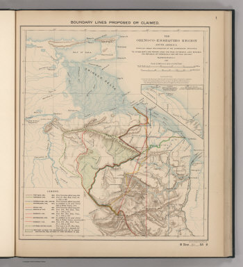
Venezuela-British Guiana Boundary Commission
Full Title
Boundary Lines Proposed or Claimed. 1. S Doc 91 55 2. The Orinoco - Essequibo Region, South America Compiled under the Direction of the Commission Appointed "To Investigate and Report upon the True Divisional Line between the Republic of Venezuela and British Guiana." 1897. Lith. by A. Hoen & Co., Baltimore, MD.
Publisher
United States of America
Author
Venezuela-British Guiana Boundary Commission
Full Title
Forests and Savannas. 2. S Doc 91 55 2. The Orinoco - Essequibo Region, South America, Compiled under the Direction of the Commission Appointed "To Investigate and Report upon the True Divisional Line between the Republic of Venezuela and British Guiana." Washington D.C. 1897. Lith. by A. Hoen & Co., Baltimore, MD.
Publisher
United States of America
|