Browse All

1837 Hydrographische Karte von Europa. Physical Atlas Hydrographische Karte von Europa, oder d … |

1837 Orographische Karte von Europa. Physical Atlas Orographische Karte von Europa, oder Bes … |

1837 Cover: Physisch-statistisch u. politisch … Physical Atlas (Covers to) Physisch-statistisch und pol … |

1857 Title Page: The Physical Geography of th … Physical Atlas (Title Page to) The Physical Geography o … |

1857 Text Page: Attribution to George Manning … Physical Atlas (Text Page to) The Physical Geography of … |

1857 Text Page: Introduction to the first edi … Physical Atlas (Text Page to) Introduction to the first … |

1857 Text Page: (Continues) Introduction to t … Physical Atlas (Text Page to) Introduction to the first … |

1857 Text Page: (Continues) Introduction to t … Physical Atlas (Text Page to) Introduction to the first … |

1857 Text Page: (Continues) Introduction to t … Physical Atlas (Text Page to) Introduction to the first … |

1857 Text Page: (Continues) Introduction to t … Physical Atlas (Text Page to) Introduction to the first … |

1857 Text Page: (Continues) Introduction to t … Physical Atlas (Text Page to) Introduction to the sixth … |

1857 I.The atmosphere. Diagram of the winds Physical Atlas I.The atmosphere. Diagram of the winds. … |

1857 II-III. Brook's deep-sea sounding appara … Physical Atlas II-III. Brook's deep-sea sounding appara … |

1857 IV. Isothermal chart of the Atlantic Oce … Physical Atlas IV. Isothermal chart of the Atlantic Oce … |

1857 V. Pilot sheet. Physical Atlas V. Pilot sheet. D. McClelland, Sc. (to a … |
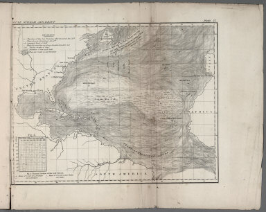
1857 VI. Gulf stream and drift Physical Atlas VI. Gulf Stream and drift. (to accompany … |

1857 VII. Geological agency of the winds Physical Atlas VII. Geological agency of the winds. D. … |

1857 VIII. Winds and routes Physical Atlas VIII. Winds and routes. (to accompany) T … |

1857 IX. Sea drift and whales Physical Atlas IX. Sea drift and whales, on which the m … |

1857 X. August and September Hurricane of 184 … Physical Atlas X. August and September Hurricane of 184 … |

1857 XI. Basin of the North Atlantic Ocean Physical Atlas XI. Basin of the North Atlantic Ocean. E … |

1857 XII. Vertical section - North Atlantic O … Physical Atlas XII. Vertical section - North Atlantic O … |

1857 XIII. Storms and rains in North and Sout … Physical Atlas XIII. Storms and rains in North and Sout … |

1827 Vents (Asie) Physical Atlas Theorie des vents (Asie, Ocean Indien, O … |

1827 Vents (Ocean Pacifique) Physical Atlas Theorie des vents (Ocean Pacifique). Gra … |

1827 Gulf-Stream. Physical Atlas Carte du courant qui sort par le Canal d … |

1827 La Manche. Physical Atlas Carte et coupe du Canal de la Manche. Bo … |

1827 Cover: Atlas encyclopedique Physical Atlas (Covers to) Atlas encyclopedique contena … |

1827 Half Title: Atlas encyclopedique Physical Atlas (Half Title Page to) Atlas encyclopediqu … |

1827 Title Page: Atlas encyclopedique Physical Atlas (Title Page to) Atlas encyclopedique con … |

1827 Contents: Atlas encyclopedique Physical Atlas (Contents to) Atlas encyclopedique conte … |

1827 Contents: Atlas encyclopedique Physical Atlas (Contents to) Atlas encyclopedique conte … |

1827 Distribution primitive du genre humain. Physical Atlas Distribution primitive du genre humain a … |

1827 Carte des glaces boreales. Physical Atlas Carte des glaces, circompolaires boreale … |

1827 Carte des glaces australes. Physical Atlas Carte des glaces, circompolaires austral … |

1827 Vents (Amerique) Physical Atlas Theorie des vents (Amerique. A Paris, Ch … |

1827 Vents (Afrique) Physical Atlas Theorie des vents (Afrique, Ocean Atlant … |

1827 Virginie, Pensylvanie. Physical Atlas Carte des montagnes coupees par des rivi … |

1827 La Charente. Physical Atlas Cours de la Charente avec ses oscillatio … |

1827 La Charente. Physical Atlas (Cours de la Charente avec ses oscillati … |

1827 La Seine. Physical Atlas Plan incline et bords escarpes de deux o … |

1827 La Marne. Physical Atlas Plan du confluent de la Marne. Grave par … |

1827 La Seine, l'Oise. Physical Atlas Plan du confluent de la Seine et de l'Oi … |

1827 La Loire, l'Indre. Physical Atlas Confluences de la Loire du Cher et de l' … |

1827 Bouches du Rhone. Physical Atlas Carte des bouches du Rhone. Gravee par B … |

1827 Bec d'Ambes. Physical Atlas Le Bec d'Ambes, confluent de la Garonne … |

1827 Morvan. Physical Atlas Carte du Morvan. A. Poiret sculp. (A Par … |

1827 Morvan. Physical Atlas Carte des limites de l'ancienne terre du … |

1827 Saxe mineralogique. Physical Atlas Carte mineralogique de la Saxe. Distribu … |

1827 St. Pierre Plateau. Physical Atlas Carte du Plateau de St. Pierre. Releve e … |