Browse All

1876 Le Tour de Monde en un Clin d'Oeil Pictorial map Le Tour de Monde en un Clin d'Oeil. Supp … |

1962 Trip Planning Map Of The United States Pocket Map Trip Planning Map Of The United States. … |

1932 The Pacific Coast where the nation will … Separate Map The Pacific Coast where the nation will … |

1935 Map of the Greyhound Lines in the United … Separate Map Map of the Greyhound Lines and Principal … |

1881 Composite: Adams' Synchronological Chart … Historical Atlas (Composite of) Adams' Synchronological C … |

1915 Covers: The "Chevalier" Commercial, Pict … Pocket Map (Covers to) The "Chevalier" Commercial, … |
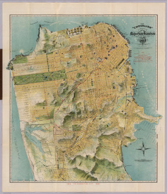
1915 The "Chevalier" Commercial, Pictorial an … Pocket Map The "Chevalier" Commercial, Pictorial an … |

1915 Index Page: The "Chevalier" Commercial, … Pocket Map (Index Page to) Untitled index to the St … |

1929 Air Route from Los Angeles to Columbus. Pocket Map (Map of the United States showing the ai … |

1929 Illustrated Map of the Route of Transcon … Pocket Map Illustrated Map of the Route of Transcon … |

1847 World At One View, 1847 Broadside World At One View. Entered ... 1847, by … |

1947 Historic York. Separate Map Historic York. Printed and Published by … |

1947 Historic York. Separate Map Historic York. Printed and Published by … |

1958 Guam Island. Marianas Islands. Separate Map Pictorial Map ... Guam Island. The Maria … |

1958 Historical Island of Guam. Separate Map The Historical Island of Guam of the Mar … |

1915 Covers: Bird's Eye View of the Panama Ca … Separate Map (Covers to) Bird's Eye View of the Panam … |

1915 Text: Panama Canal Photographs and Descr … Separate Map (Text Page) (Panama Canal Photographs an … |

1915 Profile of Panama Canal. Bird's Eye View … Separate Map Profile of Panama Canal. Bird's Eye View … |

1935 California Pacific International Exposit … Separate Map The California Pacific International Exp … |

1935 California Pacific International Exposit … Separate Map California Pacific International Exposit … |

1949 Booklover's Map of the United States. Separate Map The Booklover's Map of the United States … |

1911 The "Chevalier" ... Map of San Francisco … Wall Map The "Chevalier" Commercial, Pictorial an … |

1945 Mapa de los Paisajes de Cuba. Separate Map Mapa de los Paisajes de Cuba por Gerardo … |

1945 California. Separate Map California. |

1948 The Americas Served by American Republic … Separate Map The Americas Served by American Republic … |

1946 Covers: Recreational map of New Mexico l … Separate Map (Covers to) Recreational map of New Mexi … |

1946 Recreational map of New Mexico : the lan … Separate Map Recreational map of New Mexico : the lan … |

1946 Text Page: Recreational map of New Mexic … Separate Map (Text Page to) Recreational map of New M … |

1928 The picture map of the Holy Land Separate Map The picture map of the Holy Land. Design … |

1930 Picture map of Massachusetts Separate Map Picture map of Massachusetts. Designed a … |

1951 Covers: Historical Trails Through New Me … Pictorial Map (Covers to) Historical trails through Ne … |

1951 Historical Trails Through New Mexico, Th … Pictorial Map Historical trails through New Mexico : t … |

1951 Text Page: Historical Trails Through New … Pictorial Map (Text Page to) Historical trails through … |

1977 The Mystery Map of Assinine Atoll Pictorial Map The Mystery Map of Assinine Atoll. (c)op … |

1926 Bootlegger's Map of the United States Pictorial Map Bootlegger's Map of the United States "H … |

1936 Copper Country - Keweenaw Land, Michigan … Guide Book Copper Country - Keweenaw Land. Gateway … |

1936 Keweenaw County, Michigan. Guide Book Keweenaw County. |

1936 Ontonagon County, Michigan. Guide Book Ontonagon County. |

1936 Gogebic County, Michigan. Guide Book Gogebic County. |

1936 Dickinson County, Michigan. Guide Book Dickinson County. |

1936 Iron County, Michigan. Guide Book Iron County. |

1936 Schoolcraft County, Michigan. Guide Book Schoolcraft County. |

1936 Luce County, Michigan. Guide Book Luce County. |

1936 Chippewa County, Michigan. Guide Book Chippewa County. |

1936 Mackinac County, Michigan. Guide Book Mackinac County. |

1936 Macinac Island, Michigan. Guide Book Macinac Island. |

1987 The Ian Fleming Thriller Map. Separate Map The Ian Fleming Thriller Map. |

1987 The Ian Fleming Thriller Map. Separate Map The Ian Fleming Thriller Map. |

1936 Menominee County, Michigan. Guide Book Menominee County. |

1936 Delta County, Michigan. Guide Book Delta County. |