|
Author
Cram, George Franklin
Full Title
Commercial Railroad and County Map Of Massachusetts and Rhode Island. Published by Geo. F. Cram, Chicago, Ill. Geo. F. Cram, Engraver & Publisher, Chicago Ill. (inset: untitled map of the Boston area).
Publisher
George F. Cram
Author
Mitchell, Samuel Augustus
Full Title
Map Of Massachusetts Connecticut And Rhode Island Constructed From the Latest Authorities. Published by S. Augustus Mitchell Philadelphia. 1831. J.H. Young Sc. (inset) Statistical Table. Pop... for all three states.
Publisher
S. Augustus Mitchell
Author
Finley, Anthony
Full Title
Massachusetts. Published by A. Finley Philada. Young & Delleker Sc. (inset) Map Of The Country in the Vicinity of Boston.
Publisher
Anthony Finley
Author
Rand McNally and Company
Full Title
Rand, McNally & Co.'s Massachusetts. Copyright, 1879, by Rand, McNally & Co., Chicago, Ill. Rand, McNally & Co., Relief Plate Map Engr's Chicago. (inset) Vicinity Of Boston. (untitled inset map of City Hall area in Boston). (with 27 page index) Rand, McNally & Co.'s Indexed Map Of Massachusetts ... Chicago: Rand, McNally & Co. ... 77 and 79 Madison Street. (on verso) Entered ... 1879, by Rand, McNally & Co. ... Washington.
Publisher
Rand McNally & Co.
Author
Tanner, Henry S.
Full Title
Massachusetts And Rhode Island: By H.S. Tanner. Published by C.S. Williams ... Philadelphia. 1846. Entered ... in the year 1841, by H.S. Tanner in the ... Eastern District of Pennsylvania. (inset map) Boston.
Publisher
C.S. Williams
Author
Finley, Anthony
Full Title
Massachusetts. (Pocket Atlas Of The New England States And New York). (with 7 maps) Connecticut, New York. Maine. New Hampshire. Vermont. Massachusetts. Rhode Island. Published by A. Finley Philada. Young & Delleker Sc.
Publisher
Anthony Finley
Author
Smith, George G.
Full Title
Plan Of Boston Comprising a Part of Charlestown and Cambridge. Published by George G. Smith, Engraver, Corner of Washington & Franklin Sts. Boston. 1846. (inset) Plan Of East Boston from actual Survey by R.H. Eddy. (inset) Plan Of South Boston From a Drawing by S.P. Fuller.
Publisher
George G. Smith, Engraver
Author
Hopkins, G.M.
Full Title
Map Of The City Of Boston and its Environs. Published by G.M. Hopkins & Co. 320 Walnut St. Philada. Engr. by E. Busch, 320 Walnut St. Philada. 1874. Printed by F. Bourquin 31 So. Sixth St. Philada. Entered ... 1873 by G.M. Hopkins ... Columbia.
Publisher
G.M. Hopkins
Author
Haynes, Tilly
Full Title
New map of Boston giving all points of interest ... Geo H. Walker & Co. Lith. 160 Tremont St. Boston. Copyright 1883 by Tilly Haynes (1884)
Publisher
Geo. H. Walker & Co.
Author
Haynes, Tilly
Full Title
Bird's eye view of Boston Harbor engraved expressly for the United States Hotel Company ... Geo H. Walker & Co. Lith., Boston. Copyright 1884 by Tilly Haynes.
Publisher
Geo. H. Walker & Co.
Author
Sampson, Murdock & Co.
Full Title
Map of Boston, for 1888. Published expressly for the Boston directory, by Sampson, Murdock & Co., 155 Franklin St., Boston. Copyright 1885 by Sampson, Murdock & Co. Forbes Co. Boston.
Publisher
Sampson, Murdock & Co.
Author
Prang, L. & Co.
Full Title
Map Of Boston, 1872, After The Latest Surveys With All The Improvements In Progress, By L. Prang & Co., Publishers Of Prang's American Chromos. 2182 Washington St., Boston. James B. Gardner, Draughtsman. Entered ... 1872, by L. Prang & Co. ... Washington. (inset) Plan Of East Boston.
Publisher
L. Prang & Co.
Author
[Bouve, Crawford & Co., Good, Charles E.]
Full Title
Correct map of Boston Harbor giving route and official summer time-table of the Nantasket Beach Steamboat Co. Compliments of Bouve, Crawford & Co., Boston, makers of the celebrated Craword Shoe and proprietors of twenty Crawford shoe stores. Office: 611 Washington St, Boston. Published by Bouve, Crawford & Co. ... Copyrighted by Bouve, Crawford & Co., June 7th, 1890.
Publisher
Bouve, Crawford & Co.
Author
Lucas, Fielding Jr.
Full Title
Massachusetts. Drawn and Published by F. Lucas Jr. Baltimore.
Publisher
Fielding Lucas Jr.
Author
Dearborn, Nathaniel
Full Title
New Map Of Massachusetts Compiled from The latest and best Authorities And Corrected by Permission From the Survey ordered by the Legislature. Carefully Revised And Additions Made In 1848. Boston. 3d. Edition Published By Nathl. Dearborn. Engraver & Printer, 104 Washington St. (inset) Boston. (4 additional inset maps).
Publisher
N. Dearborn
Author
Dutton, E.P.
Full Title
New Map Of Massachusetts Compiled from The latest and best Authorities. Published At The Boston Map Store, E.P. Dutton & Co. 135 Washington Street, Boston, 1869. Entered ... 1863 by E.P Dutton & Co ... Massachusetts. (inset) Salem. (inset) Springfield. (inset) Worchester. (inset) Lowell. (inset) Boston.
Publisher
E.P. Dutton
Author
Morse, Sidney E.
Full Title
Massachusetts, Rhode-Island And Connecticut. On the Improved Plan of Sidney E. Morse, A.M. Entered ... second day of May, 1827, By Sidney E. Morse ... Connecticut. Published by N. & S.S. Jocelyn, New-Haven, Con. 1827. N. & S.S. Jocelyn Sc. (inset) Boston and its Vicinity.
Publisher
N. & S.S. Jocelyn
Author
Beers, Frederick W.
Full Title
Plan Of Berkshire Co. Massachusetts. Published Expressly For S. E. Nichols, Bookseller & Stationer, Pittsfield, Mass. Copyrighted 1876, by F. W. Beers & Co. (inset) Pittsfield. Scale 160 Rods to the inch.
Publisher
F.W. Beers & Co.
Author
Dearborn, Nathaniel
Full Title
New Map Of Massachusetts Compiled from The Latest and Best Authorities And Corrected by Permission From the Survey ordered by the Legislature in 1830. Carefully Revised And Additions Made In 1839. Boston. 3d. Edition Published By Nathl. Dearborn, Engraver & Printer, 53 Washington St. 1840. (inset) Boston. (4 additional inset maps).
Publisher
N. Dearborn
Author
Barber, John Warner
Full Title
Massachusetts & Rhode Island.
Publisher
J.W. Barber
Author
Bowles, Samuel
Full Title
Map of the City of Springfield Mass. Published by Samuel Bowles & Co. 1868. Engraved and Printed by Milton Bradley & Co. Practical Engravers & Lithographers. 247 Main St. Springfield.
Publisher
Samuel Bowles & Co.
Author
Brown & Parsons
Full Title
Map Of Massachusetts, Connecticut And Rhode Island Constructed from the Latest Authorities. Published by Brown & Parsons Hartford, Ct. 1847.
Publisher
Brown & Parsons.
Author
Dutton, E.P.
Full Title
New Map Of Massachusetts Compiled from The latest and best Authorities. Published At The Boston Map Store, E.P. Dutton & Co. 135 Washington Street, Boston, 1866. Entered ... 1863 by E.P Dutton & Co ... Massachusetts. (inset) Salem. (inset) Springfield. (inset) Worchester. (inset) Lowell. (inset) Boston.
Publisher
E.P. Dutton
Author
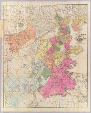
Williams, A. & Co.
Full Title
A. Williams & Co. Railroad & Township Map Of Massachusetts. Published at the Boston Map Store. 283 Washington St. 1878. Entered ... 1876 by Cook and Ellis ... Washington D.C. Lith. by J. Mayer & Co. No 4 State St.
Publisher
The Boston Map Store
Author
Jocelyn, N. & S.S.
Full Title
Map Exhibiting the Farmington, & Hampshire & Hampden Canals, Together with the Line of their proposed continuation through the Valley of the Connecticut River, to Canada. Engraved and published by N. & S.S. Jocelyn. New Haven, 1828. Entered ... August 1st 1828 by N. & S.S. Jocelyn ... Connt. (inset) Profile of the Canals. Surveys furnished by Davis Hurd Esqr. Chief Engineer.
Publisher
N. & S.S. Jocelyn
Author
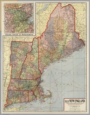
Kenyon Company
Full Title
Map of New England ... Copyright 1920 The Kenyon Company, Inc., Map Makers Des Moines, Iowa. Principal Automobile Highways Shown Thus ... (inset) Eastern Portion Of Massachusetts. (on verso) Index of New England States, With Official 1920 Census...
Publisher
The Kenyon Company, Inc.
Author
Chase, Ernest Dudley, 1878-1966
Full Title
Historic Massachusetts : a travel map to help you feel at home in the Bay State. Massachusetts. Department of Commerce, 334 Boylston St. Boston, 16 Mass. Designed and drawn by Ernest Dudley Chase. (on verso) A world of fun and relaxation, Massachusetts, the historic vacationland : a travel map to help you feel at home in the Bay State. "Form 97-150M-7-57-920616 Publication of the document approved by George J. Cronin, Staff purchasing agent".
Publisher
Dept. of Commerce
Author
Cram, George Franklin
Full Title
(Covers to) Commercial Railroad and County Map Of Massachusetts and Rhode Island. Published by Geo. F. Cram, Chicago, Ill. Geo. F. Cram, Engraver & Publisher, Chicago Ill. (inset: untitled map of the Boston area).
Publisher
George F. Cram
Author
Cram, George Franklin
Full Title
(Title Page to) Commercial Railroad and County Map Of Massachusetts and Rhode Island. Published by Geo. F. Cram, Chicago, Ill. Geo. F. Cram, Engraver & Publisher, Chicago Ill. (inset: untitled map of the Boston area).
Publisher
George F. Cram
Author
Mitchell, Samuel Augustus
Full Title
(Covers to) Map Of Massachusetts Connecticut And Rhode Island Constructed From the Latest Authorities. Published by S. Augustus Mitchell Philadelphia. 1831. J.H. Young Sc. (inset) Statistical Table. Pop... for all three states.
Publisher
S. Augustus Mitchell
Author
Finley, Anthony
Full Title
(Covers to) Massachusetts. Published by A. Finley Philada. Young & Delleker Sc. (inset) Map Of The Country in the Vicinity of Boston.
Publisher
Anthony Finley
Author
Rand McNally and Company
Full Title
(Covers to) Rand, McNally & Co.'s Massachusetts. Copyright, 1879, by Rand, McNally & Co., Chicago, Ill. Rand, McNally & Co., Relief Plate Map Engr's Chicago. (inset) Vicinity Of Boston. (untitled inset map of City Hall area in Boston). (with 27 page index) Rand, McNally & Co.'s Indexed Map Of Massachusetts ... Chicago: Rand, McNally & Co. ... 77 and 79 Madison Street. (on verso) Entered ... 1879, by Rand, McNally & Co. ... Washington.
Publisher
Rand McNally & Co.
Author
Rand McNally and Company
Full Title
(Title Page to) Rand, McNally & Co.'s Massachusetts. Copyright, 1879, by Rand, McNally & Co., Chicago, Ill. Rand, McNally & Co., Relief Plate Map Engr's Chicago. (inset) Vicinity Of Boston. (untitled inset map of City Hall area in Boston). (with 27 page index) Rand, McNally & Co.'s Indexed Map Of Massachusetts ... Chicago: Rand, McNally & Co. ... 77 and 79 Madison Street. (on verso) Entered ... 1879, by Rand, McNally & Co. ... Washington.
Publisher
Rand McNally & Co.
Author
Tanner, Henry S.
Full Title
(Covers to) Massachusetts And Rhode Island: By H.S. Tanner. Published by C.S. Williams ... Philadelphia. 1846. Entered ... in the year 1841, by H.S. Tanner in the ... Eastern District of Pennsylvania. (inset map) Boston.
Publisher
C.S. Williams
Author
Smith, George G.
Full Title
(Covers to) Plan Of Boston Comprising a Part of Charlestown and Cambridge. Published by George G. Smith, Engraver, Corner of Washington & Franklin Sts. Boston. 1846. (inset) Plan Of East Boston from actual Survey by R.H. Eddy. (inset) Plan Of South Boston From a Drawing by S.P. Fuller.
Publisher
George G. Smith, Engraver
Author
Hopkins, G.M.
Full Title
(Covers to) Map Of The City Of Boston and its Environs. Published by G.M. Hopkins & Co. 320 Walnut St. Philada. Engr. by E. Busch, 320 Walnut St. Philada. 1874. Printed by F. Bourquin 31 So. Sixth St. Philada. Entered ... 1873 by G.M. Hopkins ... Columbia.
Publisher
G.M. Hopkins
Author
Haynes, Tilly
Full Title
(Covers to) New map of Boston giving all points of interest ... Geo H. Walker & Co. Lith. 160 Tremont St. Boston. Copyright 1883 by Tilly Haynes. (with map) Bird's eye view of Boston Harbor, engraved expressly for the United States Hotel Company, showing routes of Nantasket Steamer Co.'s boats ... Geo H. Walker & Co. Lith. Boston. Copyright 1884 by Tilly Haynes.
Publisher
Geo. H. Walker & Co.
Author
Sampson, Murdock & Co.
Full Title
(Covers to) Map of Boston, for 1888. Published expressly for the Boston directory, by Sampson, Murdock & Co., 155 Franklin St., Boston. Copyright 1885 by Sampson, Murdock & Co. Forbes Co. Boston.
Publisher
Sampson, Murdock & Co.
Author
Prang, L. & Co.
Full Title
(Covers to) Map Of Boston, 1872, After The Latest Surveys With All The Improvements In Progress, By L. Prang & Co., Publishers Of Prang's American Chromos. 2182 Washington St., Boston. James B. Gardner, Draughtsman. Entered ... 1872, by L. Prang & Co. ... Washington. (inset) Plan Of East Boston.
Publisher
L. Prang & Co.
Author
[Bouve, Crawford & Co., Good, Charles E.]
Full Title
(Covers to) Correct map of Boston Harbor giving route and official summer time-table of the Nantasket Beach Steamboat Co. Compliments of Bouve, Crawford & Co., Boston, makers of the celebrated Craword Shoe and proprietors of twenty Crawford shoe stores. Office: 611 Washington St, Boston. Published by Bouve, Crawford & Co. ... Copyrighted by Bouve, Crawford & Co., June 7th, 1890.
Publisher
Bouve, Crawford & Co.
Author
[Bouve, Crawford & Co., Good, Charles E.]
Full Title
(Verso of) Correct map of Boston Harbor giving route and official summer time-table of the Nantasket Beach Steamboat Co. Compliments of Bouve, Crawford & Co., Boston, makers of the celebrated Craword Shoe and proprietors of twenty Crawford shoe stores. Office: 611 Washington St, Boston. Published by Bouve, Crawford & Co. ... Copyrighted by Bouve, Crawford & Co., June 7th, 1890.
Publisher
Bouve, Crawford & Co.
Author
Lucas, Fielding Jr.
Full Title
(Covers to) Massachusetts. Drawn and Published by F. Lucas Jr. Baltimore.
Publisher
Fielding Lucas Jr.
Author
Dearborn, Nathaniel
Full Title
(Covers to) New Map Of Massachusetts Compiled from The latest and best Authorities And Corrected by Permission From the Survey ordered by the Legislature. Carefully Revised And Additions Made In 1848. Boston. 3d. Edition Published By Nathl. Dearborn. Engraver & Printer, 104 Washington St. (inset) Boston. (4 additional inset maps).
Publisher
N. Dearborn
Author
Dutton, E.P.
Full Title
(Covers to) New Map Of Massachusetts Compiled from The latest and best Authorities. Published At The Boston Map Store, E.P. Dutton & Co. 135 Washington Street, Boston, 1869. Entered ... 1863 by E.P Dutton & Co ... Massachusetts. (inset) Salem. (inset) Springfield. (inset) Worchester. (inset) Lowell. (inset) Boston.
Publisher
E.P. Dutton
Author
DeSilver, Robert
Full Title
(Covers to) The State of Massachusetts.
Publisher
Robert, DeSilver
Author
DeSilver, Robert
Full Title
The State of Massachusetts.
Publisher
Robert, DeSilver
Author
Morse, Sidney E.
Full Title
(Covers to) Massachusetts, Rhode-Island And Connecticut. On the Improved Plan of Sidney E. Morse, A.M. Entered ... second day of May, 1827, By Sidney E. Morse ... Connecticut. Published by N. & S.S. Jocelyn, New-Haven, Con. 1827. N. & S.S. Jocelyn Sc. (inset) Boston and its Vicinity.
Publisher
N. & S.S. Jocelyn
Author
Andrus & Judd
Full Title
(Covers to) The States Of Massachusetts, Connecticut And Rhode Island From the best Authorities. Published by Andrus & Judd Hartford, Conn. 1832. Copy Right secured according to Act of Congress.
Publisher
Andrus & Judd
Author
Andrus & Judd
Full Title
The States Of Massachusetts, Connecticut And Rhode Island From the best Authorities. Published by Andrus & Judd Hartford, Conn. 1832. Copy Right secured according to Act of Congress.
Publisher
Andrus & Judd
Author
Beers, Frederick W.
Full Title
(Covers to) Plan Of Berkshire Co. Massachusetts. Published Expressly For S. E. Nichols, Bookseller & Stationer, Pittsfield, Mass. Copyrighted 1876, by F. W. Beers & Co. (inset) Pittsfield. Scale 160 Rods to the inch.
Publisher
F.W. Beers & Co.
|