Who What Where WhenREMOVEWHO
WHEN
|
Author
Finley, Anthony
Full Title
Vermont. (Pocket Atlas Of The New England States And New York). (with 7 maps) Connecticut, New York. Maine. New Hampshire. Vermont. Massachusetts. Rhode Island. Published by A. Finley Philada. Young & Delleker Sc.
Publisher
Anthony Finley
Author
Finley, Anthony
Full Title
Massachusetts. (Pocket Atlas Of The New England States And New York). (with 7 maps) Connecticut, New York. Maine. New Hampshire. Vermont. Massachusetts. Rhode Island. Published by A. Finley Philada. Young & Delleker Sc.
Publisher
Anthony Finley
Author
Finley, Anthony
Full Title
Rhode Island. (Pocket Atlas Of The New England States And New York). (with 7 maps) Connecticut, New York. Maine. New Hampshire. Vermont. Massachusetts. Rhode Island. Published by A. Finley Philada. Young & Delleker Sc.
Publisher
Anthony Finley
Author
Ream, Robert L.
Full Title
Sectional Map Of Nebraska Territory Compiled from the Field Notes in the Surveyor General's Office, by Robert L. Ream. Showing the Counties, Townships, Sections, Topography, Cities, Villages, and all Internal Improvements &c. Published by E. Mendenhall, at his General Map Establishment, Walnut Street, Cincinnati, O. 1857. Middleton Wallace & Co. Lithographers, Cincinnati, O. Entered ... 1857 by Robert L. Ream ... Ohio.
Publisher
E. Mendenhall.
Author
Perrine, Charles O.
Full Title
Perrine's New Topographical War Map Of The Southern States. Taken from the latest Government Surveys and Official Reports. E.R. Jewett & Co., Engravers, Buffalo, N.Y. Entered ... 1863, by C.O. Perrine ... Indiana. (inset) Southern Part Of Florida.
Publisher
Chas 0. Perrine.
Author
Drew, Columbus
Full Title
Drew's New Map Of The State Of Florida Showing the Townships by the U.S. Surveys, the Completed & Projected Railroads, The Different Railroad Stations And Growing Railroad Towns, The New Towns on the Rivers and interior, and the New Counties, up to the Year 1876. Published by C. Drew, Bookseller & Stationer, Jacksonville, Fla. Entered ... 1873, by Columbus Drew ... Washington.
Publisher
C. Drew
Author
Finley, Anthony
Full Title
Maine. Published by A. Finley, Philada. Young & Delleker Sc.
Publisher
Anthony Finley
Author
Perrine, Charles O.
Full Title
Perrine's New Military Map Illustrating The Seat of War. Entered according to Act of Congress, in the year 1862, by C. O. Perrine, in the Clerk's Office of the District Court of the State of Indiana. (with) Inset map of Southern Part of Florida.
Publisher
Mumford & Co.
Author
[Gunn, O.B., Mitchell, D.T.]
Full Title
Gunn & Mitchell's New Map Of Kansas And The Gold Mines Embracing all the Public Surveys up to 1866 Principal Meridian. Compiled from the Original Field Notes by O.B. Gunn & D.T. Mitchell. Lawrence, Kan. 1867 ... January 1st, 1867. H.S. Sleeper, Surveyor General Kansas and Nebraska. Entered ... 1862 by Gunn & Mitchell ... Kansas. Krebs & Bro. lith. Pittsburgh, Pa.
Publisher
O.B. Gunn & D.T. Mitchell
Author
Temple, J.G.
Full Title
Map Of The New Alaska Gold Fields Showing The Kougrock, Bluestone, Council City, Nome And Copper River Districts. Compiled By J.G. Temple, From Field Notes Made On The Ground, From The Latest Government Surveys, And From The Most Reliable Authorities. Jan., 1901. Entered ... 1901, by J.G. Temple... Notice To Publishers And Others: Any Infringement Of This Map Will Be Prosecuted. Issued By The Seattle Daily Times Seattle, Washington. Price 50 (cents). (inset) Map Of Copper River And Vicinity. Jan. 1901. C.F. Oliver, 1901.
Publisher
The Seattle Daily Times
Author
Thayer, H. L.
Full Title
Thayer's Map Of Colorado. Published by Richards & Co. Denver, Colorado. 1873. Third Edition. Rufus Blanchard Engraver.
Publisher
Richards & Co.
Author
Snow, William Parker, 1817-1895.
Full Title
Official map of the Territory of Montana. Drawn for the use of the Territorial schools. By William P. Snow, 1886. George E. Boos & Co. Helena, Montana. Engraved and manufactured by G.W. & C.B. Colton & Co., New York. Copyright 1885 by William P. Snow.
Publisher
[G.W. & C.B. Colton & Co., George E. Boos & Co.]
Author
Gibbes, C.D.
Full Title
A New Map Of California. By Charles Drayton Gibbes From his own and other Recent Surveys and Explorations. MDCCCLII. Published by C.D. Gibbes, Stockton, Cal. Sherman & Smith, New York. Entered ... 1852 by Sherman & Smith ... New York. (inset) Map Of The United States Of America, Mexico, Central America, Cuba &c.
Publisher
C.D. Gibbes
Author
Thayer, H. L.
Full Title
Thayer's Map of Denver Colorado. Located to Tp. Nos 3&4 South Range No. 68 West Arapahoe County. Published by H.L Thayer. Real Estate Mining And Loan Agent Denver. 1879. Thayer's Map Publishing House ... No. 354-1/2 Lawrence Street. Entered ... 1878, by H.L. Thayer ... Washington.
Publisher
H.L. Thayer
Author
[Rollandet, Edward, Thayer, H. L.]
Full Title
Thayer's New Map Of The State of Colorado Compiled From Official Surveys And Explorations. Published by H.L. Thayer, Denver Col. 1880. Established in 1871. Drawn By Edward Rollandet. Entered ... 1878 by H.L Thayer ... Washington.
Publisher
H.L. Thayer
Author
Townsend & Dale
Full Title
Map of the Oil Region of Pennsylvania. Published by Townsend & Dale. Meadville, Pa. 1865. Otto Krebs, lith. Pittsburgh. Copy Right Secured according to Act of Congress, 1865.
Publisher
Townsend & Dale.
Author
Magnus, Charles
Full Title
Map Of The United States of America, The British Provinces, Mexico, the West Indies and Central America. Published by Charles Magnus. New York. 1854. (inset map) Central America.
Publisher
Charles Magnus
Author
Colton, J. H.
Full Title
The United States Of America 1853. Published By J.H. Colton No. 86 Cedar St. New York. Entered ... 1853, by J.H. Colton ... New York. Printed by D. Mc. Lellan 26 Spruce St. N.Y.
Publisher
J.H. Colton.
Author
Cram, George Franklin
Full Title
New Sectional Map Of The State Of Illinois. Engraved From Official Draughts Of Each County. Published by George F. Cram. Proprietor Of The Western Map Depot. 55. W. Lake Street, Chicago, Ill. 1873. Entered ... 1872, by G.F. Cram ... Washington. G.F. Cram Lith. Chicago. St. Louis Publisher, E.H. Ross. 313 Locust St. St. Louis, Mo.
Publisher
George F. Cram ; St. Louis: E.H. Ross.
Author
U.S. General Land Office
Full Title
Indian Territory. 1879. Department Of The Interior, General Land Office, J.A. Williamson, Commissioner. Compiled from the official Records of the General Land Office and other sources by C. Roeser, Principal Draughtsman, G.L.O. Photo lith & print by Julius Bien 16 & 18 Park Place, N.Y.
Publisher
Julius Bien
Author
Sinclair, Thomas
Full Title
Map of Mexico Showing the Seat of War. Lith. of T. Sinclair, 79 So. 3rd St. Philadelphia.
Publisher
Thomas Sinclair
Author
Sleem, D.H.
Full Title
Sleem's Map Of Central Alaska Showing ... Routes Of Travel And The Line Of Alaska Northern Railway From Seward To Fairbanks. Compiled from U.S. Government and R.R. Surveys, reliable prospectors and personal reconnaissance by D.H. Sleem, A.B., M.S., M.D. Copyright, 1910, by D.H. Sleem, Seward, Alaska. (inset) Iditarod And Innoko Districts.
Publisher
D.H. Sleem
Author
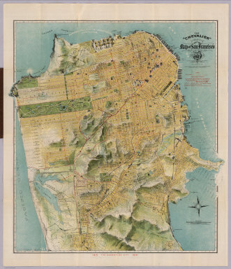
Chevalier, August
Full Title
The "Chevalier" Commercial, Pictorial and Tourist Map of San Francisco From Latest U.S. Gov. and Official Surveys. Designed-Engraved And Copyrighted By Aug. Chevalier, Lithographer Publisher, 507 Mission St. San Francisco ... The Exposition City 1915. Copyrighted 1912 By Aug. Chevalier ... (on verso) Untitled index to the street, parks, Public Schools ... of San Francisco.
Publisher
August Chevalier
Author
Smith, George G.
Full Title
Plan Of Boston Comprising a Part of Charlestown and Cambridge. Published by George G. Smith, Engraver, Corner of Washington & Franklin Sts. Boston. 1846. (inset) Plan Of East Boston from actual Survey by R.H. Eddy. (inset) Plan Of South Boston From a Drawing by S.P. Fuller.
Publisher
George G. Smith, Engraver
Author
Security Savings Bank
Full Title
Security Map And Street Railway Guide of the City of Los Angeles and Vicinity with Map of Beaches and nearby Points of Interest. Copyright 1908 by Security Savings Bank Los Angeles, California ... Presented Free With Compliments Of Security Savings Bank. Security Bldg. Spring And Fifth Sts. (inset) Extension Of Hollywood. (inset) Extension Of Garvanza South Pasadena. (inset) Map Showing The "Shoestring" Annexed to the City of Los Angeles. (on verso, map of the Vicinity of Los Angeles) Security Map 1907. (on verso) Depot Lines.
Publisher
Security Savings Bank
Author
[Sidney, J.C., Smith, Robert P.]
Full Title
Sidney's Map of Ten Miles round. Map Of The Circuit Ten Miles Around The City Of Philadelphia With the names of Villages, Roads, Mills, Property Owners, Taverns, &c From Original Surveys by J.C. Sidney, C.E. ... Delaware Co. by Dr. Ash. Robert P. Smith, Publisher 144, Chestnut Street, Philadelphia 1847. Entered ... 1847 by Robert P. Smith ... Pennsylva. Drawn by J.C. Sidney. Prd. at P.S. Duval's Establmnt.
Publisher
Robert P. Smith
Author
Transcontinental Air Transport, Inc.
Full Title
(Map of the United States showing the air route from Los Angeles, California to Columbus, Ohio). Copyright, Rand McNally & Company.
Publisher
Transcontinental Air Transport, Inc.
Author
Texas Land and Immigration Company
Full Title
Map of the state of Texas. Woodward, Tiernan & Hale, Map Engr's St. Louis. Texas Land and Immigration Co. St. Louis, Mo. (1876)
Publisher
Woodward, Tiernan & Hale
Author
Transcontinental Air Transport, Inc.
Full Title
Illustrated Map of the Route of Transcontinental Air Transport, Inc. TAT. Copyright, Rand McNally & Company. 7134 - New York 6-29.
Publisher
Transcontinental Air Transport, Inc.
Author
Williams, William
Full Title
The Tourist's Map of the State of New York Compiled from the latest Authorities. Utica. Published by William Williams, 1828. Engraved by V. Balch & S. Stiles. (inset) Profile Of The Grand Erie Canal. (inset) Profile Of The Champlain Canal.
Publisher
William William
Author
Rand McNally and Company
Full Title
Texas. Rand, McNally & Co's New Business Atlas Map of Texas. Copyright, 1910 ... 1903 ... Rand McNally & Co., Map Publishers and Engravers, Chicago, 1910. (two untitled inset maps of the northern and southern tips of Texas).
Publisher
Rand McNally and Company
Author
Henn, Williams & Co.
Full Title
A Township Map Of The State Of Iowa. Compiled from the United States Surveys, official information and personal reconnaissance, showing the Streams, Roads, Towns, County Seats, Works of Internal Improvement, &c. &c. Published by Henn, Williams & Co. Fairfield, Iowa. and by R.L. Barnes, Philadelphia. No. 6 South 7th. Street 1855. Friend & Aub Lith. Phila. Entered ... 1854, by R.L Barnes ... Penna.
Publisher
Henn, Williams & Co.
Author
[Lea, I., Carey, H.C.]
Full Title
New York. Drawn by F. Lucas, Jr. Engd. by J. Yeager. (inset) Profile of Levels of the Grand Canal.
Publisher
H.C. Carey & I. Lea.
Author
Hopkins, G.M.
Full Title
Map Of The City Of Boston and its Environs. Published by G.M. Hopkins & Co. 320 Walnut St. Philada. Engr. by E. Busch, 320 Walnut St. Philada. 1874. Printed by F. Bourquin 31 So. Sixth St. Philada. Entered ... 1873 by G.M. Hopkins ... Columbia.
Publisher
G.M. Hopkins
Author
Haynes, Tilly
Full Title
New map of Boston giving all points of interest ... Geo H. Walker & Co. Lith. 160 Tremont St. Boston. Copyright 1883 by Tilly Haynes (1884)
Publisher
Geo. H. Walker & Co.
Author
Haynes, Tilly
Full Title
Bird's eye view of Boston Harbor engraved expressly for the United States Hotel Company ... Geo H. Walker & Co. Lith., Boston. Copyright 1884 by Tilly Haynes.
Publisher
Geo. H. Walker & Co.
Author
Colton, G.W. & C.B.
Full Title
Colton's Railroad & Township Map of the State of Ohio. Published By G.W. & C.B. Colton, No. 172 William St. New York. 1867. Entered ... 1851 by J.H. Colton ... New York.
Publisher
G.W. & C.B. Colton
Author
Colton, G.W. & C.B.
Full Title
Colton's New Township Map of Pennsylvania & the Southern Counties Of New York. Published By G.W. & C.B. Colton & Co. 172 William Street, New York. 1869. Drawn, Engraved, Printed and colored at Coltons Geographical Establishment. No. 172 William St. New York., Entered ... 1866, by G.W. & C.B. Colton, ... New York.
Publisher
G.W. & C.B. Colton & Co.
Author
Cram, George Franklin
Full Title
Cram's Railroad & County Map Of Virginia, W. Virginia, Maryland & Delaware. Published By Geo. F. Cram. Proprietor Of The Western Map Depot. 262-264 Wabash, Ave. Chicago, Ills. 1881. Entered ... 1878, by G.F. Cram... Washington D.C.
Publisher
George F. Cram
Author
Colton, G.W. & C.B.
Full Title
Colton's New Township Map of the State of Pennsylvania. Published by G.W. & C.B. Colton & Co. New York, 1870. Entered ... 1865 by G. Woolworth Colton ... New York.
Publisher
G.W. & C.B. Colton & Co.
Author
Tanner, Henry S.
Full Title
A Map Of The United States Of Mexico, As organized and defined by the several Acts of the Congress of that Republic. Constructed from a great variety of Printed and Manuscript Documents by H.S. Tanner. Third Edition, 1846. Published by H.S. Tanner. Entered ... 1846, by H.S. Tanner ... New York. (inset) Map Of The Roads &c. From Vera Cruz & Alvarado To Mexico.
Publisher
H.S. Tanner
Author
Tanner, Henry S.
Full Title
A Map Of The United States Of Mexico, As organized and defined by the several Acts of the Congress of that Republic. Constructed from a great variety of Printed and Manuscript Documents by H.S. Tanner. 1826. Entered ... 10th day of June 1825, by H.S. Tanner ... (inset) Map Of The Roads &c. From Vera Cruz & Alvarado To Mexico.
Publisher
H.S. Tanner
Author
Tanner, Henry S.
Full Title
Illinois And Missouri. By H.S. Tanner. 1840. Published by H.S. Tanner, Philadelphia. Entered ... 1839, by H.S. Tanner ... Pennsylvania. Engraved by H.S. Tanner & Assistants.
Publisher
H.S. Tanner
Author
Tanner, Thomas R.
Full Title
A New & Authentic Map of the State of Michigan and Territory of Wisconsin. Constructed principally from the United States Surveys. By Thomas R. Tanner, 1839. Chas. E. Ely Sc. Philada. Published by H.S. Tanner, Philadelphia. Entered ... 1839, by H.S. Tanner ... Pennsylvania.
Publisher
H.S. Tanner
Author
Kenyon Company
Full Title
Map Of New England With population and Location of the Principal Towns and Cities according to Latest Reliable Statistics ... Copyrighted 1910 by The Kenyon Company, Map Makers, Des Moines, Iowa. (on verso) Location and Population of towns and Cities in New England According to the United States Census of 1910.
Publisher
The Kenyon Company
Author
Sampson, Murdock & Co.
Full Title
Map of Boston, for 1888. Published expressly for the Boston directory, by Sampson, Murdock & Co., 155 Franklin St., Boston. Copyright 1885 by Sampson, Murdock & Co. Forbes Co. Boston.
Publisher
Sampson, Murdock & Co.
Author
Prang, L. & Co.
Full Title
Map Of Boston, 1872, After The Latest Surveys With All The Improvements In Progress, By L. Prang & Co., Publishers Of Prang's American Chromos. 2182 Washington St., Boston. James B. Gardner, Draughtsman. Entered ... 1872, by L. Prang & Co. ... Washington. (inset) Plan Of East Boston.
Publisher
L. Prang & Co.
Author
[Gibbes, C.D., Holt, Warren]
Full Title
Map of the States Of California And Nevada. Carefully Compiled from the Latest Authentic Sources. By Chas. Drayton Gibbes, C.E. Comprising Information obtained from the U.S. Coast And Land Surveys ... And Others. Published by Warren Holt. No. 607 Clay Street, San Francisco, Cal. 1873. Entered ... 1873 by Warren Holt ... Washington. S. Blinton Formerly of the U.S. Coast Survey Draughtsman & Lithographer. 148-1/2 S. Fourth Street, Philadelphia, Pa.
Publisher
Warren Holt
Author
[Blanchard, Rufus, Ranney, Adolphus.]
Full Title
Map Of The United States. Published By Adolphus Ranney, 195 Broadway, New-York. Entered ... 1854, by Rufus Blanchard ... New York. Electrotyped by Filmer & Co., 128 Fulton St., New York.
Publisher
A. Ranney.
Author
Cram, George Franklin
Full Title
Cram's Township And Rail Road Map Of The North West. Published By George F. Cram, Proprietor Of The Western Map Depot. 66 Lake St.: Chicago, Ills. 1878. Entered ... 1878, by G.F. Cram ... Washington D.C.
Publisher
George F. Cram
|