Who What Where WhenWHEREShow More |
Author
Atlantic Coast Line Railroad Company
Full Title
(Text Page to) The Atlantic Coast Line north and south ... C.G. Crawford, Printer and Stationer, 49 & 51 Park Place N.Y. September 7, 1885.
Publisher
C.G. Crawford
Author
Atchison, Topeka, and Santa Fe Railroad Company
Full Title
Route of the California Limited -- "Santa Fe all the way."
Publisher
Rand McNally
Author
Atchison, Topeka, and Santa Fe Railroad Company
Full Title
(Covers to) The California Limited. Pictures by C.D. Williams. 1903-1904 Santa Fe. Copyright, 1903, by Geo. T. Nicholson.
Publisher
Rand McNally
Author
Atchison, Topeka, and Santa Fe Railroad Company
Full Title
(Title Page) The California Limited. Pictures by C.D. Williams. 1903-1904 Santa Fe. Copyright, 1903, by Geo. T. Nicholson.
Publisher
Rand McNally
Author
Atchison, Topeka, and Santa Fe Railroad Company
Full Title
Santa Fe. Poole Bros., Chicago.
Publisher
Poole Bros.
Author
Atchison, Topeka, and Santa Fe Railroad Company
Full Title
(Covers to) Santa Fe. The Atchison, Topeka & Santa Fe Railway and connecting lines. Oct. 10, 1904.
Publisher
Poole Bros.
Author
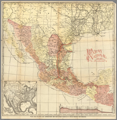
Mexico National R.R.
Full Title
Mexico National R.R. and Connections.
Publisher
Mexico National R.R.
Author
Rand McNally and Company
Full Title
(South West section, Rand, McNally & Co.'s New Shippers' Railroad Map of the United States. Scale: 18 miles to one inch).
Publisher
Rand McNally & Co.
Author
Rand McNally and Company
Full Title
(Covers to) (Rand, McNally & Co.'s New Shippers' Railroad Map of the United States. Scale: 18 miles to one inch).
Publisher
Rand McNally & Co.
Author
Rand McNally and Company
Full Title
(Composite Map of) (Western section of Rand, McNally & Co.'s New Shippers' Railroad Map of the United States. Scale: 18 miles to one inch).
Publisher
Rand McNally & Co.
Author
Rand McNally and Company
Full Title
(Text Page) Alphabetical List of All Railroads.
Publisher
Rand McNally and Company
Author
Rand McNally and Company
Full Title
(Text Page) Alphabetical List of All Railroads.
Publisher
Rand McNally and Company
Author
Rand McNally and Company
Full Title
(Text Page) Alphabetical List of All Railroads. Railroads Grouped by Systems.
Publisher
Rand McNally and Company
Author
Rand McNally and Company
Full Title
Commercial Atlas of America. Rand McNally Black and White Mileage Map, Mexico. (with) Mexico City and Vicinity.
Publisher
Rand McNally and Company
Author
[Lubrecht, Charles, Rosa, R.]
Full Title
(Covers to) The American Continent. Topographical and railroad map of the United States, British Possessions, West Indies, Mexico and Central America. Compiled from the best authorities, by R. Rosa, late Col. 46th Regt. N.Y.S. Vol. Published by Ch. Lubrecht & Co., 12 Frankfort Street, New York. 1864. Agents For Great Britain: Bacon & Co., 48 Paternoster Row, London, England. For Germany, Switzerland And Italy: Fr. Volkmar, Leipsic. Lubrecht & Co., Stuttgart. Revised Edition. Entered ... 1864, by Ch. Lubrecht & Co. ... New York. (with) Central America.
Publisher
Charles Lubrecht & Co.
Author
[Lubrecht, Charles, Rosa, R.]
Full Title
The American Continent. Topographical and railroad map of the United States, British Possessions, West Indies, Mexico and Central America. Compiled from the best authorities, by R. Rosa, late Col. 46th Regt. N.Y.S. Vol. Published by Ch. Lubrecht & Co., 12 Frankfort Street, New York. 1864. Agents For Great Britain: Bacon & Co., 48 Paternoster Row, London, England. For Germany, Switzerland And Italy: Fr. Volkmar, Leipsic. Lubrecht & Co., Stuttgart. Revised Edition. Entered ... 1864, by Ch. Lubrecht & Co. ... New York. (with) Central America.
Publisher
Charles Lubrecht & Co.
Author
Mitchell, Samuel Augustus Jr.
Full Title
Map of Mexico, Central America, and the West Indies. (with) Map of the Bermuda Islands. (with) Map of the island of Jamaica. (with) Map of the proposed ship rail road route across the isthmus of Tehuantepec. (with) Map of the Panama Railroad and proposed canal. (with) Map of the proposed Nicaragua Canal route. Copyright by S. Augustus Mitchell 1884.
Publisher
Wm. M. Bradley & Bro.
Full Title
Map of Mexico, Central America, and the West Indies. (with) Map of the Bermuda Islands. (with) Map of the island of Jamaica. (with) Map of the proposed ship rail road route across the isthmus of Tehuantepec. (with) Map of the Panama Railroad and proposed canal. (with) Map of the proposed Nicaragua Canal route. Copyright 1886 by Wm. M. Bradley & Bro.
Publisher
Wm. M. Bradley & Bro.
Author
Rand McNally and Company
Full Title
(Covers to) Rand, McNally & Co's. general map of the Republic of Mexico constructed from the best authorities showing completed & proposed railways, steamship routes and telegraphic communications. Chicago, U.S. 1882. Rand, McNally & Co., Map Publisher and Engravers, Chicago, Ill. Copyrighted, 1882 by Rand, McNally & Co., Chicago, Ill.
Publisher
Rand McNally & Co.
Author
Rand McNally and Company
Full Title
Rand, McNally & Co's. general map of the Republic of Mexico constructed from the best authorities showing completed & proposed railways, steamship routes and telegraphic communications. Chicago, U.S. 1882. Rand, McNally & Co., Map Publisher and Engravers, Chicago, Ill. Copyrighted, 1882 by Rand, McNally & Co., Chicago, Ill.
Publisher
Rand McNally & Co.
|