|
Author
Palmer, William. J.
Full Title
Map Of The Route Of The Southern Continental R.R. With Connections From Kansas City Mo. Ft. Smith Ark. And Shreveport La. Giving a general View of the Recent Surveys of the Kansas Pacific Railway Co, across the Continent Made in 1867 & 1868 under the direction of Gen. Wm. J. Palmer. On the routes of the 32nd and 35th Parallels. J.F Gedney Lith, Washington, D.C.
Publisher
J.F. Gedney Lith.
Author
Palmer, William. J.
Full Title
Map Of The Route Of The Southern Continental R.R. With Connections From Kansas City Mo. Ft. Smith Ark. And Shreveport La. Giving a general View of the Recent Surveys of the Kansas Pacific Railway Co, across the Continent Made in 1867 & 1968 under the direction of Gen. Wm. J. Palmer. On the routes of the 32nd and 35th Parallels together with compilations from Keeler's Official Map showing the Central and Northern Routes to the Pacific, and the intermediate topography. J.F Gedney Lith, Washington, D.C.
Publisher
J.F. Gedney Lith.
Author
Southern Pacific Company
Full Title
(Covers to:) California, Texas, Mexico And Arizona Southern Pacific Co. "Sunset route" from New Orleans to the Pacific Coast ... January, 1892. American Bank Note Co., N.Y.
Publisher
Poole Brothers.
Author
Southern Pacific Company
Full Title
California, Texas, Mexico And Arizona Southern Pacific Co. "Sunset route" from New Orleans to the Pacific Coast ... January, 1892. American Bank Note Co., N.Y.
Publisher
Poole Brothers.
Author
Southern Pacific Company
Full Title
Correct map of the railway & steamship lines operated by the Southern Pacific Company [United States and Mexico]. Poole Bros., Map Engravers, Chicago. (inset) County map of Texas showing the Atlantic System of the Southern Pacific Company. (inset) San Francisco, California. (inset) Los Angeles, California. (inset) New Orleans. (inset) San Antonio, Texas.
Publisher
Poole Brothers.
Author
Williams, Henry T.
Full Title
Williams' New Trans-Continental Map Of The Pacific R.R. And Routes Of Overland Travel To Colorado, Nebraska, The Black Hills, Utah, Idaho, Nevada, Montana, California And The Pacific Coast. Henry T. Williams, Publisher 46 Beekman St. N.Y. Entered ... 1877 by H.T. Williams ... Washington. Am. Photo-Litho. Co. N.Y. (Osborne's Process.)
Publisher
Henry T. Williams
Author
Rand McNally and Company
Full Title
(Denver and Rio Grande Railroad System). Rand, McNally & Co., Engravers, Chicago. (view) Alabaster Hall. (untitled inset map of the Western States).
Publisher
Rand McNally and Company
Author
Rand McNally and Company
Full Title
Denver and Rio Grande Railroad System. Denver & Rio Grande R.R. Scenic Line Of The World. (untitled inset map of the Western States).
Publisher
Rand McNally
Author
[Abbot, Henry L., Humphreys, A.A., Warren, Gouverneur Kemble, 1830-1882]
Full Title
Profiles of the main routes surveyed, compiled in 1855, by Lieutenants G.K. Warren & H.L. Abbot, Corps Topl. Engineers; with revisions and additional compilations from the results of subsequent examinations and surveys. Prepared in the Office of Pacific Rail Road Explorations and Surveys. Captain A.A. Humphreys, Corps Topl. Engineers, in charge, by direction of Hon. Jefferson Davis, Secretary of War. 1856. Explorations and Surveys for the Rail Road Routes from the Mississippi River to the Pacific Ocean, War Department. (with) Profiles of rail roads constructed across the Alleghany mountains.
Publisher
[A.O.P. Nicholson I-XI, T. Ford XII.]
Author
[Beckwith, E.G., Gunnison, J.W.]
Full Title
Profiles from Explorations and Surveys made under the direction of the Hon. Jefferson Davis Secretary of War. No. 1 Route near the 41st parallel; from Ft. Bridger to Ft. Reading by Capt. E.G. Beckwith, 3d. Artillery. No. 2 Route near the 38th & 39th parallel; from Westport to Sevier River by Capt. G.W. (i.e. J.W.) Gunnison, Topl. Engrs., assisted by Capt. E.G. Beckwith, 3d. Artillery. Profile made under the supervision of E.G. Beckwith, 3d. Art. 1855. (1861)
Publisher
[A.O.P. Nicholson I-XI, T. Ford XII.]
Author
[Campbell, A. H. (Albert H.), Ives, J.C., Whipple, A.W.]
Full Title
General profile from Fort Smith, Arkansas, to Martinez, near San Francisco, California, to accompany the maps of Explorations and Surveys made under the direction of Hon. Jefferson Davis, Secretary of War by Lieut. A.W. Whipple, Topl. engrs., assisted by Lieut. J.C. Ives, Topl. Engr., A.H. Campbell, civil engr. & surveyor, Wm. White, Jr., N.H. Hilton, J.P. Sherburne, asst. surveyors. 1853-4. Route near the 35th Parallel. (1861)
Publisher
[A.O.P. Nicholson I-XI, T. Ford XII.]
Author
Parke, John G.
Full Title
Profiles from San Francisco Bay to Los Angeles, Cala. and from the Pimas Villages to Fort Fillmore from Explorations and Surveys made under the direction of The Hon. Jefferson Davis, Secretary of War by Lieut. John G. Parke, Topl. Engrs., assisted by Albert H. Campbell, Civil Engineer and N.H. Hutton, H. Custer and G.G. Garner, assts. 1854 & 55. Explorations and Surveys for a Rail Road Route from the Mississippi River to the Pacific Ocean. War Department. Route near the 32d parallel & coast route, Cala.
Publisher
[A.O.P. Nicholson I-XI, T. Ford XII.]
Author
[Pacific Railroad Survey, Warren, Gouverneur Kemble, 1830-1882]
Full Title
(Covers to) Reports of Explorations and Surveys, to Ascertain the Most Practicable and Economical Route for a Railroad From the Mississippi River to the Pacific Ocean. Made Under the Direction of the Secretary of War, In 1853-56, According to Acts of Congress of March 3, 1853, May 31, 1854, and August 5, 1854. Volume XI. Washington: George W. Bowman, Printer. 1861. 36th Congress, 2d Session, Senate, Ex. Doc.
Publisher
[A.O.P. Nicholson I-XI, T. Ford XII.]
Author
[Pacific Railroad Survey, Warren, Gouverneur Kemble, 1830-1882]
Full Title
(Contents Page to) Reports of Explorations and Surveys, to Ascertain the Most Practicable and Economical Route for a Railroad From the Mississippi River to the Pacific Ocean. Made Under the Direction of the Secretary of War, In 1853-56, According to Acts of Congress of March 3, 1853, May 31, 1854, and August 5, 1854. Volume XI. Washington: George W. Bowman, Printer. 1861. 36th Congress, 2d Session, Senate, Ex. Doc.
Publisher
[A.O.P. Nicholson I-XI, T. Ford XII.]
Author
[Pacific Railroad Survey, Warren, Gouverneur Kemble, 1830-1882]
Full Title
(Title Page to) Memoir to accompany the Map of the territory of the United States from the Mississippi River to the Pacific Ocean, giving a brief account of each of the exploring expeditions since A.D. 1800, with a detailed description of the method adopted in compiling the general map. By Lieut. Gouverneur K. Warren, Corps of Topographical Engineers, U.S.A. 1859.
Publisher
[A.O.P. Nicholson I-XI, T. Ford XII.]
Author
[Pacific Railroad Survey, Warren, Gouverneur Kemble, 1830-1882]
Full Title
(Contents Page to) Memoir to accompany the Map of the territory of the United States from the Mississippi River to the Pacific Ocean, giving a brief account of each of the exploring expeditions since A.D. 1800, with a detailed description of the method adopted in compiling the general map. By Lieut. Gouverneur K. Warren, Corps of Topographical Engineers, U.S.A. 1859.
Publisher
[A.O.P. Nicholson I-XI, T. Ford XII.]
Author
[Pacific Railroad Survey, Warren, Gouverneur Kemble, 1830-1882]
Full Title
(Contents Page to) Topographical maps, profiles, and sketches to illustrate the various Reports of Surveys for railroad routes from the Mississippi River to the Pacific Ocean. Washington, D.C., 1861.
Publisher
[A.O.P. Nicholson I-XI, T. Ford XII.]
Author
Watson, Gaylord
Full Title
(Covers to) Watson's New County and Railroad Map of the Pacific States Published by G. Watson, No. 16 Beekman Street, New York. 1876. Engraved by Louis E. Neuman, 36 Vesey St., New York. Entered ... 1874 by Gaylord Watson ... Washington.
Publisher
New York: Gaylord Watson
Author
Watson, Gaylord
Full Title
Watson's New County and Railroad Map of the Pacific States Published by G. Watson, No. 16 Beekman Street, New York. 1876. Engraved by Louis E. Neuman, 36 Vesey St., New York. Entered ... 1874 by Gaylord Watson ... Washington.
Publisher
New York: Gaylord Watson
Author
Colton, G.W. & C.B.
Full Title
(Covers to) Map Of The Pacific Rail Road Route From The Mississippi River To The Pacific Ocean. Published By G.W. & C.B. Colton & Co. 172 William St. New York.
Publisher
G.W. & C.B. Colton & Co.
Author
Colton, G.W. & C.B.
Full Title
Map Of The Pacific Rail Road Route From The Mississippi River To The Pacific Ocean. Published By G.W. & C.B. Colton & Co. 172 William St. New York.
Publisher
G.W. & C.B. Colton & Co.
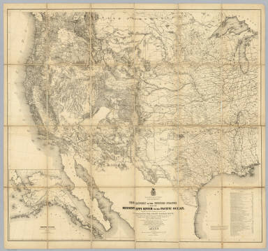
Author
Warren, Gouverneur Kemble, 1830-1882
Full Title
Map Of The Territory Of The United States From The Mississippi River To The Pacific Ocean; Originally prepared to accompany the Reports of the Explorations For A Pacific Railroad Route ... Compiled from authorized explorations and other reliable data by Lieut. G.K. Warren, Top'l. Eng'rs. In the Office of Pacific R.R. Surveys, War Dept. under the direction of Bvt. Maj. W.H. Emory, Top'l. Eng'rs. in 1854. Capt. A.A. Humphreys, Top'l. Eng'rs. in 1854-58. And partly recompiled and redrawn under the direction of the Engineer Bureau in 1865-66-67. Engineer Bureau, War Department. Engraved on stone by Julius Bien, New York.
Publisher
Julius Bien
Author
[Freyhold, Edward, Warren, Gouverneur Kemble, 1830-1882]
Full Title
Territory Of The United States From The Mississippi River To The Pacific Ocean; Originally prepared to accompany the Reports of the Explorations For A Pacific Railroad Route ... Compiled from authorized explorations and other reliable data by Lieut. G.K. Warren, Top'l. Eng'rs. In the Office of Pacific R.R. Surveys, War Dept. under the direction of Bvt. Maj. W.H. Emory, Top'l. Eng'rs. in 1854. Capt. A.A. Humphreys, Top'l. Eng'rs. in 1854-58. Recompiled and redrawn under the direction of the Chief of Corps of Engineers By Edward Freyhold 1865-66-67-68. Head Quarters Corp Of Engineers, War Department. Engraved & printed by Julius Bien, N.Y. (inset) Territory Of Alaska Ceded By Russia To The United States 1868.
Publisher
Julius Bien
Author
[Pacific Railroad Survey, Warren, Gouverneur Kemble, 1830-1882]
Full Title
(Title Page to) Reports of Explorations and Surveys, to Ascertain the Most Practicable and Economical Route for a Railroad From the Mississippi River to the Pacific Ocean. Made Under the Direction of the Secretary of War, In 1853-56, According to Acts of Congress of March 3, 1853, May 31, 1854, and August 5, 1854. Volume XI. Washington: George W. Bowman, Printer. 1861. 36th Congress, 2d Session, Senate, Ex. Doc.
Publisher
[A.O.P. Nicholson I-XI, T. Ford XII.]
Author
[Pacific Railroad Survey, Warren, Gouverneur Kemble, 1830-1882]
Full Title
(Title Page to) Topographical maps, profiles, and sketches to illustrate the various Reports of Surveys for railroad routes from the Mississippi River to the Pacific Ocean. Washington, D.C., 1861.
Publisher
[A.O.P. Nicholson I-XI, T. Ford XII.]
Author
Knight, Edward H.
Full Title
Map Of The Country Tributary To The Northern Pacific Railroad. Compiled from English, Canadian, and American official sources and original Surveys by Edward H. Knight. Jan. 1st. 1871. The compilation of English and Canadian charts and Surveys embracing the Northerly region of this Map, was platted in connection with the official U.S. War Department Map (the lower portion) at the Bureau of U.S. Topographical Engineers by the kind permission of Maj. Gen. A.A. Humphreys. (with profile).
Publisher
No Publisher
Author
[Union Pacific Railroad, Dodge, G.M.]
Full Title
Map of the Union Pacific Rail Road Surveys of 1864, 65, 66, 67, 1868 from Missouri River to Humboldt Wells Scale 20 miles to 1 inch. G.M. Dodge, Chief Engineer. H. Lambach, del. January 1869. (with profile) Profile Of Grades.
Publisher
Union Pacific Railroad Company
Author
Letts, Son & Co.
Full Title
United States of North America, and part of Canada. Western sheet. (with) Sections of Central Pacific Railway, and proposed Canadian Pacific Railway. Letts's popular atlas. Letts, Son & Co. Limited, London. (1883)
Publisher
Letts, Son & Co.
Author
[Northern Pacific Railroad Company, Rand McNally and Company]
Full Title
Map of the Northern Pacific Railroad and connections. Rand, McNally & Co., Engr's., Chicago.
Publisher
Rand McNally
Author
[Northern Pacific Railroad Company, Rand McNally and Company]
Full Title
(Covers to) Black Hills, Montana, Upper Missouri and Yellowstone Rivers, Northern Dakota and Minnesota, the Northern Pacific Rail Road in connection with the Northwestern Express, Stage & Transp'n Co. ... During season of navigation of 1879 ... July, 1879. Rand, McNally & Co., Printers, 77 and 79 Madison Street, Chicago.
Publisher
Rand McNally
Author
[Northern Pacific Railroad Company, Rand McNally and Company]
Full Title
(Text Page to) Black Hills, Montana, Upper Missouri and Yellowstone Rivers, Northern Dakota and Minnesota, the Northern Pacific Rail Road in connection with the Northwestern Express, Stage & Transp'n Co. ... During season of navigation of 1879 ... July, 1879. Rand, McNally & Co., Printers, 77 and 79 Madison Street, Chicago.
Publisher
Rand McNally
Author
Great Northern Railway Company (U.S.)
Full Title
Great Northern Railway line and connections. (with:) Karte des Red River Thales in vergrossertem Masstabe. Knight, Leonard & Co., engr's., Chi(cago)
Publisher
Great Northern Eisenbahn
Author
Great Northern Railway Company (U.S.)
Full Title
(Covers to) Das Red River Thal in Minnesota und Nord-Dakota. Das beste und fruchtbarste Land in America. Die Getreidekammer der Welt. Ein gutes Heim und Reichthum fur Deutsche Landwirthe.
Publisher
Great Northern Eisenbahn
Author
Great Northern Railway Company (U.S.)
Full Title
(Text Page to) Das Red River Thal in Minnesota und Nord-Dakota. Das beste und fruchtbarste Land in America. Die Getreidekammer der Welt. Ein gutes Heim und Reichthum fur Deutsche Landwirthe.
Publisher
Great Northern Eisenbahn
Author
St. Paul, Minneapolis & Manitoba Railway Company.
Full Title
St. Paul, Minneapolis & Manitoba Ry. Manitoba-Pacific route. Matthews, Northrup & Co., art-printing works, Buffalo, N.Y. (1887)
Publisher
Matthews, Northrup & Co.
Author
St. Paul, Minneapolis & Manitoba Railway Company.
Full Title
(Covers to) St. Paul, Minneapolis & Manitoba Ry. Red River Valley Line through the park region ... 2 +87. Matthews, Northrup & Co., Art-Printing Works, Buffalo, N.Y.
Publisher
Matthews, Northrup & Co.
Author
St. Paul, Minneapolis & Manitoba Railway Company.
Full Title
(Text Page to) St. Paul, Minneapolis & Manitoba Ry. Red River Valley Line through the park region ... 2 +87. Matthews, Northrup & Co., Art-Printing Works, Buffalo, N.Y.
Publisher
Matthews, Northrup & Co.
Author
Northern Pacific Railroad Company
Full Title
Map showing land grant of the Northern Pacific Railroad Co. in Western Washington and Northern Oregon. Corrected up to August 20, 1888 ... Matthews, Northrup & Co., Art-Printing Works, Buffalo, N.Y. (inset map) Northern Pacific Railroad and connections.
Publisher
Matthews, Northrup & Co.
Author
Northern Pacific Railroad Company
Full Title
(Covers to) Map showing land grant of the Northern Pacific Railroad Co. in Western Washington and Northern Oregon. Corrected up to August 20, 1888 ... Matthews, Northrup & Co., Art-Printing Works, Buffalo, N.Y.
Publisher
Matthews, Northrup & Co.
Author
Northern Pacific Railroad Company
Full Title
(Text Page to) Map showing land grant of the Northern Pacific Railroad Co. in Western Washington and Northern Oregon. Corrected up to August 20, 1888 ... Matthews, Northrup & Co., Art-Printing Works, Buffalo, N.Y.
Publisher
Matthews, Northrup & Co.
Author
Northern Pacific Railroad Company
Full Title
The Yellowstone Park and dining car route to the Pacific Coast. Rand, McNally & Co., Engr's, Chicago. (inset) Map of the Northern Pacific Rail Road and connections.
Publisher
[Poole Bros., Rand McNally]
Author
Northern Pacific Railroad Company
Full Title
(Covers to) The Northern Pacific R.R. The Yellowstone Park and dining car route to the Pacific Coast. Poole Bros. Printers and Engravers, Chicago.
Publisher
[Poole Bros., Rand McNally]
Author
Northern Pacific Railroad Company
Full Title
(Text Page to) The Northern Pacific R.R. The Yellowstone Park and dining car route to the Pacific Coast. Poole Bros. Printers and Engravers, Chicago.
Publisher
[Poole Bros., Rand McNally]
Author
[Chicago, Burlington & Quincy Railroad Company, Northern Pacific Railroad Company]
Full Title
Burlington Route - Northern Pacific Railway. Yellowstone National Park. Copyrighted, 1898, by Poole Bros., Chicago ... (1901)
Publisher
Poole Bros.
Author
[Chicago, Burlington & Quincy Railroad Company, Northern Pacific Railroad Company]
Full Title
(Covers to) Burlington Route - Northern Pacific Railway. Yellowstone National Park. Copyrighted, 1898, by Poole Bros., Chicago ... (1901)
Publisher
Poole Bros.
Author
[Chicago, Burlington & Quincy Railroad Company, Northern Pacific Railroad Company]
Full Title
(Text Page to) Burlington Route - Northern Pacific Railway. Yellowstone National Park. Copyrighted, 1898, by Poole Bros., Chicago ... (1901)
Publisher
Poole Bros.
Author
Northern Pacific Railway Company
Full Title
(Text Page to) The Yellowstone National Park via Northern Pacific Railway. Northern Pacific, Yellowstone Park Line. Puget Sound and Alaska. (inset) Northern Pacific Railway and connections. Poole Bros., Chicago. (inset of steamship routes to southeastern Alaska from Puget Sound)
Publisher
Poole Bros.
Author
Atchison, Topeka, and Santa Fe Railroad Company
Full Title
Santa Fe. Poole Bros., Chicago.
Publisher
Poole Bros.
|