Who What Where WhenREMOVEWHEREShow More |
Author
Jefferys, Thomas
Full Title
A new chart of the coast of Guyana from Rio Orinoco to River Berbice, containing the Dutch colonies of Poumaron, Issequibo and Demerary, and Berbice. (By Thomas Jefferys). London, printed for R. Sayer, Map & Chartseller, no. 53 Fleet Street, as the Act directs, 1 June 1787.
Publisher
Sayer and Bennett
Author
Jefferys, Thomas
Full Title
(Covers to) The West-India atlas: or, a compendious description of the West-Indies: illustrated with forty one correct charts and maps, taken From actual surveys. Together with an historical account of the several countries and islands which compose that part of the world. By the late Thomas Jefferys, Geographer to the King. London: Printed for Robert Sayer and John Bennett, Map, Chart, Print-Sellers, and Globe Makers, Fleet-Street, M,DCC,LXXXIII.
Publisher
Sayer and Bennett
Author
Jefferys, Thomas
Full Title
(Engraved title page to) The West-India atlas: or, a compendious description of the West-Indies: illustrated with forty one correct charts and maps, taken From actual surveys. Together with an historical account of the several countries and islands which compose that part of the world. By the late Thomas Jefferys, Geographer to the King. London: Printed for Robert Sayer and John Bennett, Map, Chart, Print-Sellers, and Globe Makers, Fleet-Street, M,DCC,LXXXIII.
Publisher
Sayer and Bennett
Author
Jefferys, Thomas
Full Title
(Title page to) The West-India atlas: or, a compendious description of the West-Indies: illustrated with forty one correct charts and maps, taken From actual surveys. Together with an historical account of the several countries and islands which compose that part of the world. By the late Thomas Jefferys, Geographer to the King. London: Printed for Robert Sayer and John Bennett, Map, Chart, Print-Sellers, and Globe Makers, Fleet-Street, M,DCC,LXXXIII.
Publisher
Sayer and Bennett
Author
Jefferys, Thomas
Full Title
(Dedication page to) The West-India atlas: or, a compendious description of the West-Indies: illustrated with forty one correct charts and maps, taken From actual surveys. Together with an historical account of the several countries and islands which compose that part of the world. By the late Thomas Jefferys, Geographer to the King. London: Printed for Robert Sayer and John Bennett, Map, Chart, Print-Sellers, and Globe Makers, Fleet-Street, M,DCC,LXXXIII.
Publisher
Sayer and Bennett
Author
Jefferys, Thomas
Full Title
(Index page to) The West-India atlas: or, a compendious description of the West-Indies: illustrated with forty one correct charts and maps, taken From actual surveys. Together with an historical account of the several countries and islands which compose that part of the world. By the late Thomas Jefferys, Geographer to the King. London: Printed for Robert Sayer and John Bennett, Map, Chart, Print-Sellers, and Globe Makers, Fleet-Street, M,DCC,LXXXIII.
Publisher
Sayer and Bennett
Author
Hayes, Eli L.
Full Title
Upper Ohio River and Valley part IV, 47 to 64 miles below Pittsburgh, 403 to 420 miles above Cincinnati. (with) New Cumberland, Hancock Co. W.V. (with) Newburgh, Sloans Sta., Jefferson Co., O. (with) McCoys Station, Jeff. Co. O. (... compiled & drawn for the publishers by E.L. Hayes, assisted by E.F. Hayes, C.M. Beresford, assisted by S.A. Charpiot, F.L. Sanford, J.H. Sherman. Published by Titus, Simmons & Titus ... Phila. 1877. Eng. by Worley & Bracher ... Printed by H.J. Toudy & Co. ... Oldach & Mergenthaler Binders ...)
Publisher
Titus, Simmons & Titus
Author
Hayes, Eli L.
Full Title
Soho Saw & Planing Mills & Barge Yards, G.O. Fawcett, Second Ave. 14th Ward, Pittsburgh, Pa. (... compiled & drawn for the publishers by E.L. Hayes, assisted by E.F. Hayes, C.M. Beresford, assisted by S.A. Charpiot, F.L. Sanford, J.H. Sherman. Published by Titus, Simmons & Titus ... Phila. 1877 ... Printed by H.J. Toudy & Co. ... Oldach & Mergenthaler Binders ...)
Publisher
Titus, Simmons & Titus
Author
Hayes, Eli L.
Full Title
Upper Ohio River and Valley part XVI, 272 to 293 miles below Pittsburgh, 174 to 195 miles above Cincinnati. (with) Bladensburg ... (with) Chambersburg, Eureka Post Office ... (with) Crown City ... (all) Gallia Co. O. (... compiled & drawn for the publishers by E.L. Hayes, assisted by E.F. Hayes, C.M. Beresford, assisted by S.A. Charpiot, F.L. Sanford, J.H. Sherman. Published by Titus, Simmons & Titus ... Phila. 1877. Eng. by Worley & Bracher ... Printed by H.J. Toudy & Co. ... Oldach & Mergenthaler Binders ...)
Publisher
Titus, Simmons & Titus
Author
Hayes, Eli L.
Full Title
Upper Ohio River and Valley part XVII, 294 to 311 miles below Pittsburgh, 156 to 173 miles above Cincinnati. (with) Kounston, Lawrence Co., Ohio. (with) Haskel Ville & Athalia, Law. Co., Ohio. (with) Guayandotte ... (with) St. Cloud ... (both) Cabell Co., W. Va. (... compiled & drawn for the publishers by E.L. Hayes, assisted by E.F. Hayes, C.M. Beresford, assisted by S.A. Charpiot, F.L. Sanford, J.H. Sherman. Published by Titus, Simmons & Titus ... Phila. 1877. Eng. by Worley & Bracher ... Printed by H.J. Toudy & Co. ... Oldach & Mergenthaler Binders ...)
Publisher
Titus, Simmons & Titus
Author
Hayes, Eli L.
Full Title
Gallipolis, Gallia Co., Ohio. (... compiled & drawn for the publishers by E.L. Hayes, assisted by E.F. Hayes, C.M. Beresford, assisted by S.A. Charpiot, F.L. Sanford, J.H. Sherman. Published by Titus, Simmons & Titus ... Phila. 1877. Eng. by Worley & Bracher ... Printed by H.J. Toudy & Co. ... Oldach & Mergenthaler Binders ...)
Publisher
Titus, Simmons & Titus
Author
Hayes, Eli L.
Full Title
Property of the Hartford City Coal & Salt Co., Hartford City, Mason Co., West Va. (... compiled & drawn for the publishers by E.L. Hayes, assisted by E.F. Hayes, C.M. Beresford, assisted by S.A. Charpiot, F.L. Sanford, J.H. Sherman. Published by Titus, Simmons & Titus ... Phila. 1877. Eng. by Worley & Bracher ... Printed by H.J. Toudy & Co. ... Oldach & Mergenthaler Binders ...)
Publisher
Titus, Simmons & Titus
Author
Hayes, Eli L.
Full Title
Upper Ohio River and Valley part XXV, 435 to 451 miles below Pittsburgh, 16 to 32 miles above Cincinnati. (with) California ... (with) Johnsonville ... (with) East Columbia ... (all) Hamilton Co., Ohio. (with) California, Campbell Co., Ky. (... compiled & drawn for the publishers by E.L. Hayes, assisted by E.F. Hayes, C.M. Beresford, assisted by S.A. Charpiot, F.L. Sanford, J.H. Sherman. Published by Titus, Simmons & Titus ... Phila. 1877. Eng. by Worley & Bracher ... Printed by H.J. Toudy & Co. ... Oldach & Mergenthaler Binders ...)
Publisher
Titus, Simmons & Titus
Author
Hayes, Eli L.
Full Title
Residence of Jacob Markley Esq., Anderson Tw'p., Hamilton Co., Ohio. (... compiled & drawn for the publishers by E.L. Hayes, assisted by E.F. Hayes, C.M. Beresford, assisted by S.A. Charpiot, F.L. Sanford, J.H. Sherman. Published by Titus, Simmons & Titus ... Phila. 1877. Eng. by Worley & Bracher ... Printed by H.J. Toudy & Co. ... Oldach & Mergenthaler Binders ...)
Publisher
Titus, Simmons & Titus
Author
[Isaacs, John D., Bascom]
Full Title
(Covers to) Preliminary Report on Harbors, Havens, and Anchorages of the Pacific Coast from San Francisco to the Straits of Juan de Fuca.
Publisher
Department of Engineering, University of California
Author
[Isaacs, John D., Bascom]
Full Title
(Title Page) Preliminary Report on Harbors, Havens, and Anchorages of the Pacific Coast from San Francisco to the Straits of Juan de Fuca.
Publisher
Department of Engineering, University of California
Author
[Isaacs, John D., Bascom]
Full Title
(Text Page) The excellent photographs were taken by Utility Squadron Two from Moffett Field, California.
Publisher
Department of Engineering, University of California
Author
[Isaacs, John D., Bascom]
Full Title
(Text Page) Introductory Page.
Publisher
Department of Engineering, University of California
Author
[Isaacs, John D., Bascom]
Full Title
SE Farralon.
Publisher
Department of Engineering, University of California
Author
[Isaacs, John D., Bascom]
Full Title
Golden Gate SF
Publisher
Department of Engineering, University of California
Author
[Isaacs, John D., Bascom]
Full Title
Bolinas Bay.
Publisher
Department of Engineering, University of California
Author
[Isaacs, John D., Bascom]
Full Title
Bolinas Bay. Duxbury Reef.
Publisher
Department of Engineering, University of California
Author
[Isaacs, John D., Bascom]
Full Title
Drakes Bay and Pt. Reyes.
Publisher
Department of Engineering, University of California
Author
[Isaacs, John D., Bascom]
Full Title
Bodega Bay.
Publisher
Department of Engineering, University of California
Author
[Isaacs, John D., Bascom]
Full Title
Bodega Bay.
Publisher
Department of Engineering, University of California
Author
[Isaacs, John D., Bascom]
Full Title
Mendocino Bay.
Publisher
Department of Engineering, University of California
Author
[Isaacs, John D., Bascom]
Full Title
Noya Harbor. Fort Bragg.
Publisher
Department of Engineering, University of California
Author
[Isaacs, John D., Bascom]
Full Title
Noyo River.
Publisher
Department of Engineering, University of California
Author
[Isaacs, John D., Bascom]
Full Title
Cape Mendocino. Blunt's Reef.
Publisher
Department of Engineering, University of California
Author
[Isaacs, John D., Bascom]
Full Title
Eel River Outlet.
Publisher
Department of Engineering, University of California
Author
[Isaacs, John D., Bascom]
Full Title
Humboldt Bay Entrance.
Publisher
Department of Engineering, University of California
Author
[Isaacs, John D., Bascom]
Full Title
Humboldt Bay Entrance. Eureka.
Publisher
Department of Engineering, University of California
Author
[Isaacs, John D., Bascom]
Full Title
Humboldt Bay Entrance.
Publisher
Department of Engineering, University of California
Author
[Isaacs, John D., Bascom]
Full Title
Trinidad Head.
Publisher
Department of Engineering, University of California
Author
[Isaacs, John D., Bascom]
Full Title
Crescent City.
Publisher
Department of Engineering, University of California
Author
[Isaacs, John D., Bascom]
Full Title
Crescent City.
Publisher
Department of Engineering, University of California
Author
[Isaacs, John D., Bascom]
Full Title
Rogue River outlet.
Publisher
Department of Engineering, University of California
Author
[Isaacs, John D., Bascom]
Full Title
Rogue River.
Publisher
Department of Engineering, University of California
Author
[Isaacs, John D., Bascom]
Full Title
Port Orford.
Publisher
Department of Engineering, University of California
Author
[Isaacs, John D., Bascom]
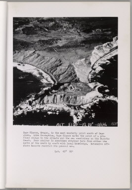
Full Title
Cape Blanco.
Publisher
Department of Engineering, University of California
Author
[Isaacs, John D., Bascom]
Full Title
Cape Blanco.
Publisher
Department of Engineering, University of California
Author
[Isaacs, John D., Bascom]
Full Title
Bandon. Coquille River.
Publisher
Department of Engineering, University of California
Author
[Isaacs, John D., Bascom]
Full Title
Bandon. Coquille River.
Publisher
Department of Engineering, University of California
Author
[Isaacs, John D., Bascom]
Full Title
Cape Arago.
Publisher
Department of Engineering, University of California
Author
[Isaacs, John D., Bascom]
Full Title
Coos Bay Entrance.
Publisher
Department of Engineering, University of California
Author
[Isaacs, John D., Bascom]
Full Title
Umpqua River entrance.
Publisher
Department of Engineering, University of California
Author
[Isaacs, John D., Bascom]
Full Title
Umpqua River. Winchester Bay.
Publisher
Department of Engineering, University of California
Author
[Isaacs, John D., Bascom]
Full Title
Siuslaw River. Munsel Lake.
Publisher
Department of Engineering, University of California
Author
[Isaacs, John D., Bascom]
Full Title
Alsea River Entrance.
Publisher
Department of Engineering, University of California
|