Who What Where WhenREMOVEWHEREShow More |
Author
[Rand McNally and Company, State Farm Insurance Companies Travel Bureau]
Full Title
Rand McNally Road map, Maritime Provinces. Copyright by Rand McNally & Company, Chicago, Ill. Lithographed in the U.S.A. (to accompany) State Farm Road Atlas: United States, Canada, Mexico,Central and South America. Copyright 1940 by Rand McNally & Company, Chicago, Ill.
Publisher
State Farm Insurance Companies Travel Bureau
Author
[Rand McNally and Company, State Farm Insurance Companies Travel Bureau]
Full Title
Rand McNally Road map, Ontario. Copyright by Rand McNally & Company, Chicago, Ill. Lithographed in the U.S.A. (inset maps) Main route to Sault Ste. Marie, and Nipissing Inset (to accompany) State Farm Road Atlas: United States, Canada, Mexico,Central and South America. Copyright 1940 by Rand McNally & Company, Chicago, Ill.
Publisher
State Farm Insurance Companies Travel Bureau
Author
[Rand McNally and Company, State Farm Insurance Companies Travel Bureau]
Full Title
Rand McNally Road map, Quebec. Copyright by Rand McNally & Company, Chicago, Ill. Lithographed in the U.S.A. (inset map) Southeastern Quebec. (to accompany) State Farm Road Atlas: United States, Canada, Mexico,Central and South America. Copyright 1940 by Rand McNally & Company, Chicago, Ill.
Publisher
State Farm Insurance Companies Travel Bureau
Author
[Rand McNally and Company, State Farm Insurance Companies Travel Bureau]
Full Title
Rand McNally Road map, Western and Central Canada. Copyright by Rand McNally & Company, Chicago, Ill. Lithographed in the U.S.A. (inset maps) Hazelton Prince george Section, Peace River Section, Lake Louise & Banff Area, and Waterton-Glacier International Peace Park. (to accompany) State Farm Road Atlas: United States, Canada, Mexico,Central and South America. Copyright 1940 by Rand McNally & Company, Chicago, Ill.
Publisher
State Farm Insurance Companies Travel Bureau
Author
[Rand McNally and Company, State Farm Insurance Companies Travel Bureau]
Full Title
Rand McNally Road map, Mexico. Copyright by Rand McNally & Company, Chicago, Ill. Lithographed in the U.S.A. (inset map) Mexico D.F. and Vicinity. (to accompany) State Farm Road Atlas: United States, Canada, Mexico,Central and South America. Copyright 1940 by Rand McNally & Company, Chicago, Ill.
Publisher
State Farm Insurance Companies Travel Bureau
Author
[Rand McNally and Company, State Farm Insurance Companies Travel Bureau]
Full Title
Rand McNally Transcontinental Mileage Chart of the United States. Copyright by Rand McNally & Company, Chicago, Ill. Lithographed in the U.S.A. (insets) Mileage distance between principal cities, Yellowstone National Park, and Distant Chart. (to accompany) State Farm Road Atlas: United States, Canada, Mexico,Central and South America. Copyright 1940 by Rand McNally & Company, Chicago, Ill.
Publisher
State Farm Insurance Companies Travel Bureau
Author
[Rand McNally and Company, State Farm Insurance Companies Travel Bureau]
Full Title
City maps. Atlanta, GA., Albany, N.Y., Atlantic City, N.I., Baltimore, MD., Birmingham, Ala., Boston, Mass. and Vicinity, and Buffalo, N.Y. and vicinity. Copyright by Rand McNally & Company, Chicago, Ill. Lithographed in the U.S.A. (to accompany) State Farm Road Atlas: United States, Canada, Mexico,Central and South America. Copyright 1940 by Rand McNally & Company, Chicago, Ill.
Publisher
State Farm Insurance Companies Travel Bureau
Author
[Rand McNally and Company, State Farm Insurance Companies Travel Bureau]
Full Title
City maps. Chicago and Vicinity. Copyright by Rand McNally & Company, Chicago, Ill. Lithographed in the U.S.A. (with two inset maps) Cincinnati, Ohio, and Columbus, Ohio. (to accompany) State Farm Road Atlas: United States, Canada, Mexico,Central and South America. Copyright 1940 by Rand McNally & Company, Chicago, Ill.
Publisher
State Farm Insurance Companies Travel Bureau
Author
[Rand McNally and Company, State Farm Insurance Companies Travel Bureau]
Full Title
City maps. Cleveland, Ohio and Vicinity. Copyright by Rand McNally & Company, Chicago, Ill. Lithographed in the U.S.A. (with four inset maps) Detroit, Mich., Dayton, Ohio, Dallas, Tex., Denver, Colo. (to accompany) State Farm Road Atlas: United States, Canada, Mexico,Central and South America. Copyright 1940 by Rand McNally & Company, Chicago, Ill.
Publisher
State Farm Insurance Companies Travel Bureau
Author
[Rand McNally and Company, State Farm Insurance Companies Travel Bureau]
Full Title
City maps. Kansas City, Kan.-Mo. and Vicinity. Copyright by Rand McNally & Company, Chicago, Ill. Lithographed in the U.S.A. (with four inset maps) Des Moines, Ia., Fort worth, Tex., Indianapolis, Ind., Milwaukee, Wis. (to accompany) State Farm Road Atlas: United States, Canada, Mexico,Central and South America. Copyright 1940 by Rand McNally & Company, Chicago, Ill.
Publisher
State Farm Insurance Companies Travel Bureau
Author
[Rand McNally and Company, State Farm Insurance Companies Travel Bureau]
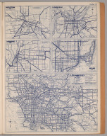
Full Title
City maps. Los Angeles, Calif. and Vicinity. Copyright by Rand McNally & Company, Chicago, Ill. Lithographed in the U.S.A. (with four inset maps) Houston, tex., Louisville, Ky., Memphis, Tenn., and Miami, Fla. (to accompany) State Farm Road Atlas: United States, Canada, Mexico,Central and South America. Copyright 1940 by Rand McNally & Company, Chicago, Ill.
Publisher
State Farm Insurance Companies Travel Bureau
Author
[Rand McNally and Company, State Farm Insurance Companies Travel Bureau]
Full Title
City maps. Minneapolis, St. Paul, Minn., and Vicinity. Philadelphia, Pa., and Vicinity. Copyright by Rand McNally & Company, Chicago, Ill. Lithographed in the U.S.A. (with two inset maps) Montreal, Que., and New Orleans, La. (to accompany) State Farm Road Atlas: United States, Canada, Mexico,Central and South America. Copyright 1940 by Rand McNally & Company, Chicago, Ill.
Publisher
State Farm Insurance Companies Travel Bureau
Author
[Rand McNally and Company, State Farm Insurance Companies Travel Bureau]
Full Title
City maps. New York and Vicinity. Copyright by Rand McNally & Company, Chicago, Ill. Lithographed in the U.S.A. (with two inset maps) Nashville, Tenn., and Niagra Falls, N.Y.-Ont. (to accompany) State Farm Road Atlas: United States, Canada, Mexico,Central and South America. Copyright 1940 by Rand McNally & Company, Chicago, Ill.
Publisher
State Farm Insurance Companies Travel Bureau
Author
[Rand McNally and Company, State Farm Insurance Companies Travel Bureau]
Full Title
City maps. Pittsburg, Pa., and Vicinity. St. Louis, Mo., and Vicinity. Copyright by Rand McNally & Company, Chicago, Ill. Lithographed in the U.S.A. (with two inset maps) Norfolk, Portsmouth, Va., and Vicinity, and Omaha, Nebr. (to accompany) State Farm Road Atlas: United States, Canada, Mexico,Central and South America. Copyright 1940 by Rand McNally & Company, Chicago, Ill.
Publisher
State Farm Insurance Companies Travel Bureau
Author
[Rand McNally and Company, State Farm Insurance Companies Travel Bureau]
Full Title
City maps. San Francisco and East Bay Cities, Calif. Copyright by Rand McNally & Company, Chicago, Ill. Lithographed in the U.S.A. (with five inset maps) Potland, Oreg., Providence, R.I., Richmond, Vs., Salt lake City, Utah, and Seattle, Wash. (to accompany) State Farm Road Atlas: United States, Canada, Mexico,Central and South America. Copyright 1940 by Rand McNally & Company, Chicago, Ill.
Publisher
State Farm Insurance Companies Travel Bureau
Author
[Rand McNally and Company, State Farm Insurance Companies Travel Bureau]
Full Title
City maps. Washington, D.C. Copyright by Rand McNally & Company, Chicago, Ill. Lithographed in the U.S.A. (with two inset maps) San Antonio, Tex., and Toledo, Ohio. (to accompany) State Farm Road Atlas: United States, Canada, Mexico,Central and South America. Copyright 1940 by Rand McNally & Company, Chicago, Ill.
Publisher
State Farm Insurance Companies Travel Bureau
Author
[Rand McNally and Company, State Farm Insurance Companies Travel Bureau]
Full Title
(Text Page to) Motor, Fish and Game Law Information. (to accompany) State Farm Road Atlas: United States, Canada, Mexico,Central and South America. Copyright 1940 by Rand McNally & Company, Chicago, Ill.
Publisher
State Farm Insurance Companies Travel Bureau
Author
Cary, John
Full Title
General Map (London Environs). Published by J. Cary, Strand, as the Act directs, July 1st, 1790.
Publisher
J. Cary
Author
Cary, John
Full Title
General Plan for Explaining the different Trusts of the Turnpike Gates in the Vicinity of the Metropolis. Published by J. Cary, July 1st. 1790.
Publisher
J. Cary
Author
Cary, John
Full Title
Explanation, Advertisement, London to Hampton Court.
Publisher
J. Cary
Author
Cary, John
Full Title
Brentford to Bagshot, Virginia Water to Oakingham.
Publisher
J. Cary
Author
Cary, John
Full Title
Egham to Binfield, Hounslow to Windsor.
Publisher
J. Cary
Author
Cary, John
Full Title
Colnbrook to Maidenhead, London to High Wycombe.
Publisher
J. Cary
Author
Cary, John
Full Title
Uxbridge to Amersham.
Publisher
J. Cary
Author
Cary, John
Full Title
London to Tring.
Publisher
J. Cary
Author
Cary, John
Full Title
Watford to Rickmans Worth to Amersham, Watford to St. Albans.
Publisher
J. Cary
Author
Cary, John
Full Title
London to Highgate & Hampstead to Hendon, London to St. Albans.
Publisher
J. Cary
Author
Cary, John
Full Title
Chipping Barnet to Welwyn, London to Hertford.
Publisher
J. Cary
Author
Cary, John
Full Title
Hoddesdon to Ware, Potters Bar to Ware, London to Bishops Stortford.
Publisher
J. Cary
Author
Cary, John
Full Title
London to Chipping Ongar.
Publisher
J. Cary
Author
Cary, John
Full Title
Stratford to Chelmsford.
Publisher
J. Cary
Author
Cary, John
Full Title
London to Rochester.
Publisher
J. Cary
Author
Cary, John
Full Title
New Cross to Maidstone.
Publisher
J. Cary
Author
Cary, John
Full Title
Lewisham to Tunbridge Wells.
Publisher
J. Cary
Author
Cary, John
Full Title
London to East Grinsted.
Publisher
J. Cary
Author
Cary, John
Full Title
Newington to Ryegate.
Publisher
J. Cary
Author
Cary, John
Full Title
Tooting to Dorking.
Publisher
J. Cary
Author
Cary, John
Full Title
Leatherhead to Guildford, London to Guildford.
Publisher
J. Cary
Author
Cary, John
Full Title
Hampton Court to Staines.
Publisher
J. Cary
Author
Cary, John
Full Title
London to Richmond.
Publisher
J. Cary
Author
Cary, John
Full Title
(Covers to) Cary's Survey of the High Roads From London to ... On a Scale of one Inch to a Mile; wherein Every Gentleman's Seat, situate on, or seen from the Road, (however distant) are laid down, with the name of the Possessor; to which is added The Number of Inns on each separate route; also, the different Turnpike Gates, shewing The Connection which one trust has with another. London: Printed for J. Cary, Engraver & Map seller, the corner of Arundel Street, Strand. July 1st, 1790.
Publisher
J. Cary
Author
Cary, John
Full Title
(Title Page to) Cary's Survey of the High Roads From London to ... On a Scale of one Inch to a Mile; wherein Every Gentleman's Seat, situate on, or seen from the Road, (however distant) are laid down, with the name of the Possessor; to which is added The Number of Inns on each separate route; also, the different Turnpike Gates, shewing The Connection which one trust has with another. London: Printed for J. Cary, Engraver & Map seller, the corner of Arundel Street, Strand. July 1st, 1790.
Publisher
J. Cary
Author
Martin de Moussy, V. (Victor), 1810-1869
Full Title
Coupe de la route de Buenos-Ayres a Lima par les Pampas et les Andes. Grave par L. Kautz, r. Bonaparte 82 - Paris. Paris, Imp. Lemercier, r. de Seine 57. (Paris Librairie de Firmin Didot Freres, Fils et Cie., 1873)
Publisher
Firmin Didot Freres.
Author
Martin de Moussy, V. (Victor), 1810-1869
Full Title
Coupe de divers passages de la Cordillere des Andes. Grave par Kautz, r. Bonaparte 82 - Paris. Paris - Imp. Lemercier, r. de Seine 57. (Paris Librairie de Firmin Didot Freres, Fils et Cie., 1873)
Publisher
Firmin Didot Freres.
Author
[Montferrier, D. A., Paz Soldan, Mariano Felipe, 1821-1886]
Full Title
Plano que manifiesta los reconocimientos de caminos hechos en el Departamento de Amazonas, por el Ingeniero del Estado D.A. Montferrier. Paz Soldan. Geografia del Peru. Grabado por F. Delamare, Paris, Calle St. Andre des Arts, 45. Paris, Imp. Lemercier. (Paris, Libreria de Augusto Durand, 1865)
Publisher
Libreria de Augusto Durand.
Author
Paz Soldan, Mariano Felipe, 1821-1886
Full Title
Linea que representa los temblores sentidos en Arequipa desde hasta 1845. Corte vertical del camino del Pacifico al Huallaga. Corte vertical del camino de Arica al Cuzco. Plano del Pongo de Manseriche. Vista segun el corte vertical. Paz Soldan. Geografia del Peru. Grabado por Delamare, Paris, Calle St. Andre des Arts 45. Paris, Imp. Janson, r. Antne. Dubois, 6. (Paris: Libreria de Augusto Durand, 1865)
Publisher
Libreria de Augusto Durand.
|