Browse All

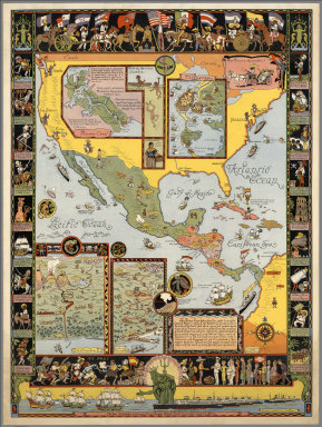
1941 Pictorial Map of the Republic of Panama … Separate Map Pictorial Map of the Republic of Panama … |

1940 Plate I. Peoples of the World. Pageant o … Separate Map Plate I. Peoples of the World. Pageant o … |

1940 Plate II. The Fauna and Flora of the Pac … Separate Map Plate II. The Fauna and Flora of the Pac … |

1940 Plate III. Art Forms of the Pacific Area … Separate Map Plate III. Art Forms of the Pacific Area … |

1940 Plate IV. Economy of the Pacific. Pagean … Separate Map Plate IV. Economy of the Pacific. Pagean … |

1940 Plate V. Native Dwellings of the Pacific … Separate Map Plate V. Native Dwellings of the Pacific … |

1940 Plate VI. Native Means of Transportation … Separate Map Plate VI. Native Means of Transportation … |

1943 Two ways to reach Japan - One may take a … Separate Map Two ways to reach Japan - One may take a … |

1942 The Pacific - Vital area for United Stat … Separate Map The Pacific - Vital area for United Stat … |

1944 Saipan conquest sets pattern for vast ae … Separate Map Saipan conquest sets pattern for vast ae … |

1935 Transcontinental routes of Pacific Greyh … Separate Map Transcontinental routes of Pacific Greyh … |

1936 A Hysterical Map Of The Yellowstone Park … Separate Map A Hysterical Map Of The Yellowstone Park … |

1937 A modern pilgrim's map of the British Is … Separate Map A modern pilgrim's map of the British Is … |

1872 L'Europe en ce moment - fantaisie politi … Separate Map Europe "L'Europe en ce moment - fantaisi … |

1927 California Separate Map California. This whimsical Carte of Topo … |

1941 Yosemite. Separate Map Yosemite. Copyright 1931. Jo Mora. |

1931 Yosemite Separate Map Yosemite. (Drawn by) Jo Mora. Copyright … |
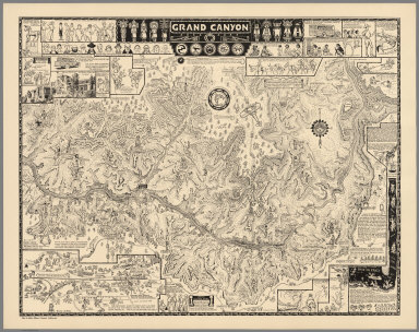
1931 Grand Canyon, 1931 Separate Map Grand Canyon. (Drawn by) Jo Mora. Copyri … |

1931 Grand Canyon Separate Map Grand Canyon. (Drawn by) Jo Mora. Copyri … |

1950 Indians of North America Separate Map Indians of North America. (Drawn by) Jo … |

1931 Yellowstone. C(opyright) Jo. Mora 1931 Separate Map Yellowstone. C(opyright) Jo. Mora 1931. … |

1942 Map of Los Angeles Historical and Recrea … Separate Map Map of Los Angeles Historical and Recrea … |

1942 (Map of Los Angeles Historical and Recre … Separate Map Map of Los Angeles Historical and Recrea … |

1926 (Monterey Peninsula and Del Monte Proper … Separate Map (Monterey Peninsula and Del Monte Proper … |

1927 The Seventeen Mile Drive. Separate Map The Seventeen Mile Drive. |

1939 (Evolution of the Cowboy). Separate Map (Evolution of the Cowboy). Copyrighted 1 … |
1933 Ye Olde Spanish Main. Separate Map Ye Olde Spanish Main. Designed and execu … |

2007 Santa Catalina Separate Map Santa Catalina. First Printing - Novembe … |

1950 Air France. Boucher, Lucien Separate Map Air France. Sur Les Ailes D'Air France D … |

1952 Air France. Boucher, Lucien Separate Map Air France. Sur Les Ailes D'Air France D … |

1959 Air France, Le Plus Grand Reseau ou Mond … Separate Map Air France, Le Plus Grand Reseau ou Mond … |

1939 Air France, "Nova Et Vetera" Sur La Viei … Separate Map Air France, "Nova Et Vetera" Sur La Viei … |

1937 Air France, Reseau Aerien Mondial. Separate Map Air France, Air France, Reseau Aerien Mo … |

1938 Air France, Reseau Aerien Mondial. Separate Map Air France, Air France, Reseau Aerien Mo … |

1947 Air France, Reseau Aerien Mondial. Separate Map Air France, Air France, Reseau Aerien Mo … |

1947 Air France, Reseau Aerien Mondial. Separate Map Air France, Air France, Reseau Aerien Mo … |

1948 Air France, Reseau Aerien Mondial. Separate Map Air France, Air France, Reseau Aerien Mo … |

1952 Air France. Boucher, Lucien Separate Map Air France. Sur Les Ailes D'Air France D … |

1943 New Zealand : her natural and industrial … Separate Map New Zealand : her natural and industrial … |

1942 Australia: her natural and industrial re … Separate Map Australia: her natural and industrial re … |

1942 Canada and Newfoundland : Their natural … Separate Map Canada and Newfoundland : Their natural … |

1943 India. Printed in England by Alf Cooke L … Separate Map India. Printed in England by Alf Cooke L … |

1943 Union of South Africa. Printed in Englan … Separate Map Union of South Africa. Printed in Englan … |

1938 Reg Mannning's Cartoon Map of Arizona. Separate Map Reg Mannning's Cartoon Map of Arizona. |

1940 A Hysterical Map of the Grand Canyon Nat … Separate Map A Hysterical Map of the Grand Canyon Nat … |

1950 A Pic-Tour Map. Honolulu, Waikiki and 'R … Separate Map A Pic-Tour Map. Honolulu, Waikiki and 'R … |

1950 A Pic-Tour Map. Honolulu, Waikiki and 'R … Separate Map A Pic-Tour Map. Honolulu, Waikiki and 'R … |

1953 Pacific Stars and Stripes Map of the (Ko … Separate Map Pacific Stars and Stripes Map of the (Ko … |

1933 Long Beach, Southern California, Los Ang … Separate Map Long Beach, Southern California, Los Ang … |

1933 Make Long Beach Your Vacation Headquarte … Separate Map Make Long Beach Your Vacation Headquarte … |