Who What Where WhenREMOVEWHERE
|
Author
Atwood, Mary Hall
Full Title
Los Angeles County. Long Beach.
Publisher
(Long Beach) Chamber of Commerce
Author
[Lites, Arthur, (Palo Alto) Chamber of Commerce]
Full Title
Palo Alto, California. A Pictorial Map.
Publisher
City of Palo Alto
Author
[Lites, Arthur, (Palo Alto) Chamber of Commerce]
Full Title
Palo Alto, Ideal Home and Recreational Center.
Publisher
City of Palo Alto
Author
[Lites, Arthur, (Palo Alto) Chamber of Commerce]
Full Title
A Pictorial Map of Palo Alto and the San Francisco Peninsula. Palo Alto, A Pictorial Map Drawn from the View Point (Birdseye) of One Aboard a Coastwise Air Liner.
Publisher
City of Palo Alto
Author
Cressy, Mike
Full Title
The Literary Map of Latin America.
Publisher
Aaron Blake Publishers
Author
[Lindgren Brothers, Lindgren, Jolly]
Full Title
A Hysterical Map of the Grand Coulee Dam.
Publisher
Lindgren Brothers
Author
C. Barnes Cartography
Full Title
Mt. Rainier National Park. --Willy Nilly Map + C. Barnes. Cart. '46 -- Wonderland Trail --
Publisher
Willy Nilly Map
Author
[Shurtleff, Elizabeth, McMillin, Helen F.]
Full Title
A Map of the Bermuda Islands. Sa des Demonias Isles of the Devils.
Publisher
[Elizabeth Shurtleff, Helen F. McMillin]
Author
Bollmann, Hermann (1911-1971)
Full Title
New York (City) Picture Map.
Publisher
Pictorial Maps, Inc.
Author
Colortext Publications Inc.
Full Title
Story Map of Ireland.
Publisher
Colortext Publications Inc.
Author
Chase, Ernest Dudley, 1878-1966
Full Title
Total War, Battle Map. Designed and Drawn by Ernest Dudley Chase of Winchester, Massachusetts, U.S.A. Certain Victory Will be Ours.
Publisher
Ernest Dudley Chase
Author
Chase, Ernest Dudley, 1878-1966
Full Title
World Wonders, A Pictorial Map. Designed and Drawn by Ernest Dudley Chase of Winchester, Mass.
Publisher
Ernest Dudley Chase
Author
Chase, Ernest Dudley, 1878-1966
Full Title
The pictorial map : United States Stamps. Designed, drawn and published by Ernest Dudley Chase. Winchester, Mass.; Research directors Charles Peck Kerr and Rupert Frank Jones. The post : Artists: Famous American Commemorative Series -- 1940.
Publisher
Ernest Dudley Chase.
Author
Sarg, Anthony
Full Title
Residential Main St. Nantucket Mass. Designed by Tony Sarg. 1937.
Publisher
No Publisher
Author
Sheets, Millard
Full Title
The Panorama Today in Northern California its resources activities and opportunities. Published on its 100th. Anniversary by American Trust Company, San Francisco. Millard Sheets. Lithogravure in U.S.A.
Publisher
American Trust Company
Author
Sheets, Millard
Full Title
The Pageant of History in Northern California its colorful and adventurous beginnings. Published on its 100th. Anniversary by American Trust Company, San Francisco. Millard Sheets. Lithogravure in U.S.A.
Publisher
American Trust Company
Author
Paine, Paul M.
Full Title
Map of America's making : a chart of places and events for those who would sail with the discoverers, seek freedom with the colonists, follow the westward trails, subdue the wilderness, and behold the building of the Republic. F. Haase. Copyright by Paul M. Paine, 1925 - 1926 - 1929 - 1939. R.R. Bowker Company. 62 West 45th Street, New York, N.Y. (inset) Where American History began [Northeast.].
Publisher
R.R. Bowker Co.
Author
Rude, Klengston
Full Title
Pano-view map : California, Nevada. Progressive. Historical. Spectacular. Recreational. Kleng Rude. C(opyright) 1962 Kleng Rude Studios, Long Beach.
Publisher
Kleng Rude Studios
Author
Lundy, Fred
Full Title
San Francisco Bay. (with) part of San Francisco and Oakland. (Drawn by) Fred Lundy - 1934. Copyright, 1934, by The Tribune Publishing Co.
Publisher
Tribune Pub. Co.
Author
Lee, Kerry
Full Title
London, The Bastion of Liberty.
Publisher
Pictorial Maps Ltd.
Author
[Shope, Irvin, Fletcher, Bob]
Full Title
Frontier - Montana - Pioneer. A One Page History Dedicated to the Pioneers.
Publisher
Montana State Highway Department
Author
Sarg, Tony (1880-1942)
Full Title
The New York 1939 Official World's Fair Pictorial Map Created by Tony Sarg.
Publisher
Tony Sarg Publications
Author
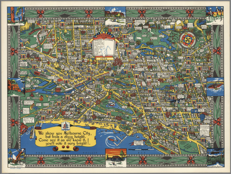
John Power Studios
Full Title
The Wonder Map of Melbourne drawn by John Power Studios.
Publisher
Wonder Maps (Aust.).
Author
[Butler, Lowell, Newbro, William H., Robinson, William W.]
Full Title
A map of the missions, presidios, pueblos, and some of the more interesting ranchos of Spanish California : together with the routes of the principal land explorations therein. Compiled by W. W. Robinson and William H. Newbro, Jr. ; edited by Phil Townsend Hanna ; cartography by Lowell Butler ; Drawings by Ken Sawyer ; color by Harry O. Diamond ; (on lower margin) December 1956, Westways, Vol. 48, No. 12. (insets) San Francisco -Monterey Area ; Los Angeles and vicinity Area.
Publisher
[Westways, Automobile Club of Southern California]
Author
[Butler, Lowell, Webb, William, Hanna, Phil Townsend, 1896-1957]
Full Title
Outdoor play places of California : a cartographic map of some of the outstanding recreational areas of the Golden State : designed by Lowell Butler with descriptive notes by William Webb and Phil Townsed Hanna. Copyright 1954 by the Automobile Club of Southern California. Drawings by Ken Sawyer. Color by Harry O. Diamond. (on lower margin) December 1954, Westways, Vol. 46, No. 12.
Publisher
[Westways, Automobile Club of Southern California]
Author
[Butler, Lowell, Webb, William, Hanna, Phil Townsend, 1896-1957]
Full Title
A Map of the Marked Historical Sites of California : Compiled from the official registrations of the California State Department of Natural Resources : By Phil Townsend Hanna and William Webb : Cartography By Lowell Butler. Copyright 1952 by the Automobile Club of Southern California. Drawing by Gordon Brusstar. Color by Harry Diamond. (on lower margin) December 1952, Westways, Vol. 44, No. 12.
Publisher
[Westways, Automobile Club of Southern California]
Author
[International Tea Market Expansion Board Limited, Gill, Leslie MacDonald, 1884-1947]
Full Title
Tea. Revives. The. World. MacDonald Gill 1940. Issued by the International Tea Market Expansion Board Limited. Printed in England. S.H.B. Ltd. Regd. No. 4950.
Publisher
International Tea Market Expansion Board Limited
Author
F.A.P. Fine additional Printers
Full Title
Silicon Valley. 1991. F.A.P. Fine Additional Printers. Mountain View.
Publisher
F.A.P.
Author
[Randall, Neil, Downs, Timothy Edwards]
Full Title
Road Map to the Best Free Stuff on the Interest.
Publisher
P.C. Computing
Author
Hayden Map Co.
Full Title
Mono County greets you : fisherman's paradise, reached via Bishop, Lee Vining, or Bridgeport. 1955, Map and resort directory of Southern Mono County. Map compiled and published by Hayden Map Co. 211 So. Kenilworth, Glendale, Cal. Copyright 1952- by Hayden Map Co. (inset) Area covered by this map. "Map No. 75555".
Publisher
Hayden Map Co.
Author
Hayden Map Co.
Full Title
(Mono County). 1955 Map and resort directory of Southern Mono County. Map compiled and published by Hayden Map Co. 211 So. Kenilworth, Glendale, Cal. Copyright 1954 Hayden Map Co. (inset) Highway detail. "No. 125655A".
Publisher
Hayden Map Co.
Author
[Ohio Commission to A Century of Progress International Exposition, Sewah Studios]
Full Title
Being a Cartograph of Ohio. The oldest state west of the thirteen original colonies; now the fourth state in the Union in population, third in manufacture; sixth in minerals mined; and among the foremost in agriculture. Published in 1933 by the Ohio. Commission to A Century of Progress International Exposition. Governor George White - Chairman, Charles F. Henry - Director, Charles H. Lewis, Charles F. Williams. Engraving by Bucher Engraving Company. Cartograph by Sewah Studios, Marietta.
Publisher
The Commission
Author
[Clark, Estra, British Railway Executive]
Full Title
A map of Yorkshire produced by British Railways. Estra Clark, 1949. Published by the Railway Executive (Eastern and North Eastern Regions). Waterlow & Sons Ltd., London and Dunstable. Printed in Great Britain. (P.P. 1096).
Publisher
[Railway Executive (Eastern and North Eastern Regions), Waterlow & Sons Ltd.]
Author
[Wylie, Ethel Earle, Van Leer, Ella Wall]
Full Title
A pictorial chart of English literature. Compiled by Ethel Earle Wyle. Illustrated by Ella Wall Van Leer. copyright 1929 by and Ran McNally & Company. Made in U.S.A.
Publisher
Rand McNally & Company
Author
Paine, Paul M.
Full Title
The booklovers' map of the British Isles. Copyright 1927; Paul M. Paine. R. R. Walker Co. 62 W. 45th St. New York N.Y. (on borders) How small the map of Britain is on paper and yet how packed with fancies. (insets) London. (and ) Edinburgh.
Publisher
R.R. Bowker Co.
Author
Paine, Paul M.
Full Title
The map of America's making : For those who would sail with Discoverers, seek Freedom with the Colonists, follow the westward trails, and behold The Building of the Republic, now in its one hundred and fiftieth year. (on lower right corner of map) PM.P. Copyright 1926; Paul M. Paine. R. R. Walker Co. 62 W. 45th St. New York N.Y.
Publisher
R.R. Bowker Co.
Author
Chase, Ernest Dudley, 1878-1966
Full Title
A pictorial map of the British Isles : By Ernest Dudley Chase. Published at Winchester, in the State of Massachusetts, U.S.A. Copyright 1935, Ernest Dudley Chase.
Publisher
Ernest Dedley Chase
Author
Chase, Ernest Dudley, 1878-1966
Full Title
Europe : A pictorial map, by Ernest Dudley Chase of Winchester, Massachusetts, U.S.A. Copyright 1938, Ernest Dudley Chase.
Publisher
Ernest Dedley Chase
Author
Chase, Ernest Dudley, 1878-1966
Full Title
A pictorial map of Switzerland, by Ernest Dudley Chase of Winchester, Massachusetts, U.S.A. Copyright 1936, Ernest Dudley Chase. Winchester, Mass. U.S.A.
Publisher
Ernest Dedley Chase
Author
Chase, Ernest Dudley, 1878-1966
Full Title
A pictorial map of Spain and Portugal, by Ernest Dudley Chase of Winchester, Massachusetts. Copyright 1935, Ernest Dudley Chase.
Publisher
Ernest Dedley Chase
Author
Chase, Ernest Dudley, 1878-1966
Full Title
France as drawn by Ernest Dudley Chase of Winchester, Massachusetts. U.S.A.Copyright 1935, Ernest Dudley Chase.
Publisher
Ernest Dedley Chase
Author
Paine, Paul M.
Full Title
Booklovers Map of America: A Chart of Certain Landmarks of Literary Geography. Copyright 1926; Paul M. Paine. R. R. Walker Co. 62 W. 45th St. New York N.Y. (with 6 insets and location map).
Publisher
R.R. Bowker Co.
Author
Berry, William D.
Full Title
Alaska. W. D. Berry. Copyright Griffins, Alaska 1967. (with key map) Key to Alaska plant and wildlife map, by William D. Berry.
Publisher
Griffin
Author
Berry, William D.
Full Title
Key to Alaska plant and wildlife map, by William D. Berry. (with) Alaska. W. D. Berry. Copyright Griffins, Alaska 1967.
Publisher
Griffin
Author
Jacobson, Egbert, G.
Full Title
The story map of England. Egbert G. Jacobson. Colortext Publications, Chicago.
Publisher
Colortext Publications, Inc.
Author
[Walker, A, Vogelear., W.E.]
Full Title
Story map of France. Colortext Publications, Inc., Chicago 1936. A. Walker W.E. Vogelear. Border design and decorations from 17th century Louis Quinze tapestries and 18th century Robert de Cotte ornaments.
Publisher
Colortext Publications, Inc.
Author
Chase, Ernest Dudley, 1878-1966
Full Title
Italy, with Vatican City : as drawn and published by Ernest Dudley Chase of Winchester, Massachusetts, USA. Copyright, Ernest Dudley Chase. U.S.A. (inset) Vatican City, area about 109 acres.
Publisher
Ernest Dudley Chase
Author
Chase, Ernest Dudley, 1878-1966
Full Title
France: as drawn and published by Ernest Dudley Chase of Winchester, Massachusetts, USA. Copyright, Ernest Dudley Chase.
Publisher
Ernest Dudley Chase
Author
Chase, Ernest Dudley, 1878-1966
Full Title
The story map of flying : Being a chronicle of man's conquest of the air : Designed, pictured and published by Ernest Dudley Chase of Winchester, Massachusetts, U.S.A. Copyright, Ernest Dudley Chase Winchester, Mass., U.S.A.
Publisher
Ernest Dudley Chase
Author
[Turzak, Charles, Chapman, Henry T.]
Full Title
Chicago. U.S.A. Designed by Charles Turzak and Henry T. Chapman. Copyright, 1931, by Houghton Mifflin Company. Litho. in U.S.A. The Tudor Press, Boston. (on borders) An illustrated map of Chicago : youthful city of the big shoulders, restless, ingenious, wilful, violent, proud to be alive.
Publisher
Houghton Mifflin Compay
|