Who What Where WhenREMOVEWHATShow MoreWHEREShow More |
Author
Freyhold, Edward
Full Title
(Composite of) Office Of The Chief Of Engineers War Department Military Map of the United States compiled and drawn by E. Freyhold 1869. Engraved & printed by Julius Bien, N.Y. (inset map) Territory Of Alaska.
Publisher
Julius Bien
Author
Freyhold, Edward
Full Title
Office Of The Chief Of Engineers War Department Military Map of the United States compiled and drawn by E. Freyhold 1869. Engraved & printed by Julius Bien, N.Y. (inset map) Territory Of Alaska.
Publisher
Julius Bien
Author
Freyhold, Edward
Full Title
Office Of The Chief Of Engineers War Department Military Map of the United States compiled and drawn by E. Freyhold 1869. Engraved & printed by Julius Bien, N.Y. (inset map) Territory Of Alaska.
Publisher
Julius Bien
Author
Freyhold, Edward
Full Title
Office Of The Chief Of Engineers War Department Military Map of the United States compiled and drawn by E. Freyhold 1869. Engraved & printed by Julius Bien, N.Y. (inset map) Territory Of Alaska.
Publisher
Julius Bien
Author
Freyhold, Edward
Full Title
Office Of The Chief Of Engineers War Department Military Map of the United States compiled and drawn by E. Freyhold 1869. Engraved & printed by Julius Bien, N.Y. (inset map) Territory Of Alaska.
Publisher
Julius Bien
Author
Freyhold, Edward
Full Title
(Composite of) Office Of The Chief Of Engineers War Department Military Map of the United States compiled and drawn by E. Freyhold 1869. Engraved & printed by Julius Bien, N.Y. (inset map) Territory Of Alaska.
Publisher
Julius Bien
Author
California: Office of State Engineer
Full Title
(State Engineer's Map of Northern California).
Publisher
California: Office of State Engineer
Author
California: Office of State Engineer
Full Title
(State Engineer's Map of Northern California).
Publisher
California: Office of State Engineer
Author
California: Office of State Engineer
Full Title
(State Engineer's Map of Northern California).
Publisher
California: Office of State Engineer
Author
California: Office of State Engineer
Full Title
(State Engineer's Map of Northern California).
Publisher
California: Office of State Engineer
Author
California: Office of State Engineer
Full Title
(State Engineer's Map of Northern California).
Publisher
California: Office of State Engineer
Author
California: Office of State Engineer
Full Title
(State Engineer's Map of Northern California).
Publisher
California: Office of State Engineer
Author
California: Office of State Engineer
Full Title
(State Engineer's Map of Northern California).
Publisher
California: Office of State Engineer
Author
California: Office of State Engineer
Full Title
(State Engineer's Map of Northern California).
Publisher
California: Office of State Engineer
Author
California: Office of State Engineer
Full Title
(State Engineer's Map of Northern California).
Publisher
California: Office of State Engineer
Author
U.S. General Land Office
Full Title
Department Of The Interior General Land Office J.A. Williamson, Commissioner. State of Iowa. 1878. Compiled from the official Records of the General Land Office and other sources by C. Roeser, Principal Draughtsman G.L.O. Photo lith & print by Julius Bien 16 & 18 Park Place N.Y.
Publisher
Julius Bien
Author
U.S. General Land Office
Full Title
Department Of The Interior General Land Office J.A. Williamson, Commissioner. State of Missouri. 1878. Compiled from the official Records of the General Land Office and other sources by C. Roeser, Principal Draughtsman G.L.O. Photo lith & print by Julius Bien 16 & 18 Park Place N.Y.
Publisher
Julius Bien
Author
U.S. General Land Office
Full Title
Department Of The Interior General Land Office J.A. Williamson, Commissioner. State of Ohio. 1878. Compiled from the official Records of the General Land Office and other sources by C. Roeser, Principal Draughtsman G.L.O. Photo lith & print by Julius Bien 16 & 18 Park Place N.Y.
Publisher
Julius Bien
Author
Jones, William A.
Full Title
Sheet No. 2. Campaign Map of the Department Of The Platte Comprising that Portion of Nebraska Lying between Long. 100-103 and Lat. 39,30-43,30 Compiled under the direction of Captain W.A. Jones Corps of Engrs. U.S.A. 1873. Published by authority of the Hon. Secretary of War in the Office of the Chief of Engineers U.S. Army.
Publisher
U.S. Army
Author
Jones, William A.
Full Title
Sheet No. 1. Campaign Map of the Department Of The Platte Comprising that Portion of Nebraska Lying between Long. 97-100 and Lat. 39,30-43,30 Compiled under the direction of Captain W.A. Jones Corps of Engrs. U.S.A. 1874. Published by authority of the Hon. Secretary of War in the Office of the Chief of Engineers U.S. Army.
Publisher
U.S. Army
Author
[Macomb, J. N. (John N.), Warner, William H. (William Hamer)]
Full Title
Map Of The Straits Of Detroit. Surveyed, Projected And Drawn By Lieutenants J.N. Macomb And W.H. Warner U.S. Corps Of Topl. Engs. 1840 '41 '42. Sheet No. 1. W.J. Stone Sc. Wash.
Publisher
U.S.
Author
Rand McNally and Company
Full Title
The Rand-McNally Official Railway Guide Map. Corrected To November 1st, 1877. (inset) Vicinity Of Boston. (inset) Vicinity Of New York And Philadelphia. (on verso) Rand-McNally Official Railway Guide Map of the Territories and the Pacific Coast.
Publisher
Rand McNally and Company
Author
Rand McNally and Company
Full Title
Rand-McNally Official Railway Guide Map of the Territories and the Pacific Coast. (on verso)The Rand-McNally Official Railway Guide Map. Corrected To November 1st, 1877. (inset) Vicinity Of Boston. (inset) Vicinity Of New York And Philadelphia.
Publisher
Rand McNally and Company
Author
Ruffner, E. H. (Ernest Howard)
Full Title
Preliminary Map Of The Surveys In Colorado Made On Reconnoissance In The Ute Country Under The Direction Of 1st Lieut. E.H. Ruffner Engineers, Chief Engineer Department Of The Missouri By Assistant H.G. Prout C.E. 1873. Engraved by Ado Hunnius.
Publisher
U.S.
Author
[Steen, E., Dixon, Joseph]
Full Title
Map Showing the Routes travelled by the Command Of Majr. E. Steen, U.S. Drags. against the Snake Indians in 1860 by Lieut. Joseph Dixon, U.S. Topl. Engrs. from explorations and surveys made by him while attached to this Command. Drawn under the direction of Capt. G. Thom U.S. Topl. Engrs. Lith. of J. Bien 180 Broadway New York.
Publisher
U.S.
Author
Tunis, W.E.
Full Title
Tunis' New Colored Railroad Map Of The United States & Canadas. Revised And Corrected Every Month. William E. Tunis, Bookseller and Stationer, 153 Jefferson Avenue, Detroit, Michigan ... Entered ... 1859, by W.E. Tunis ... New York.
Publisher
W.E. Tunis
Author
U.S. General Land Office
Full Title
Map of the Public Surveys in California ; to Accompany Report of Surveyor Genl., 1854. P.S. Duval & Co's Steam Lith. Press. Phila. Surveyor General's Office, San Francisco, Calif., Sept. 28th, 1854, Approved John C. Hays, U.S. Sur. Genl. Cal.
Publisher
P.S. Duval
Author
U.S. General Land Office
Full Title
Map of the Public Surveys in California ; to Accompany Report of Surveyor Genl., 1855. Lith. by A. Hoen & Co. Balto. Surveyor General's Office, San Francisco, Calif., Sept. 30th, 1855, Approved John C. Hays, U.S. Sur. Genl. Cal.
Publisher
A. Hoen & Co.
Author
U.S. General Land Office
Full Title
Map of the Public Surveys in California ; to Accompany Report of Surveyor Genl., 1856. Surveyor General's Office, San Francisco, Calif., Sept. 30th, 1856, Approved, U.S. Sur. Genl. Cal.
Publisher
Surveyor General's Office
Author
U.S. General Land Office
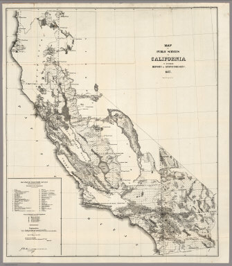
Full Title
Map of the Public Surveys in California ; to Accompany Report of Surveyor Genl., 1857. Wagner & McGuigan Lith. Phila. Surveyor Generals' Office, San Francisco, California, September 30th, 1857, Approved J.W. Mandeville, U.S. Surr. Genl. Cala.
Publisher
Wagner & McGuigan
Author
U.S. General Land Office
Full Title
Map of the Public Surveys in California ; to Accompany Report of Surveyor Genl., 1858. Lith. by Siebert & Kogge, Washington Dist. Colba. Surveyor Generals' Office, San Francisco, California, September 18th, 1858. J.W. Mandeville, U.S. Surr. Genl. Cala.
Publisher
Siebert & Kogge
Author
U.S. General Land Office
Full Title
Map of the Public Surveys in California ; to Accompany Report of Surveyor Genl., 1859. Lith. of J. Bien, 180 Broadway, N.Y. Surveyor Generals' Office, San Francisco, California, September 19th, 1859. J.W. Mandeville, U.S. Surr. Genl. Cala.
Publisher
J. Bien
Author
U.S. General Land Office
Full Title
Map of the Public Surveys in California ; to Accompany Report of Surveyor Genl., 1860. Lith. of J. Bien, 180 Broadway, N.Y. Surveyor Generals' Office, San Francisco, California, September 15th, 1860. J.W. Mandeville, U.S. Surveyor General California.
Publisher
J. Bien
Author
U.S. General Land Office
Full Title
Map of the Public Surveys in California ; to Accompany Report of Surveyor Genl., 1861. Lith. of J. Bien, 180 Broadway, N.Y. Surveyor Generals' Office, San Francisco, California, September 15th, 1861. E.F. Beale, U.S. Survr. Genl. Cal.
Publisher
J. Bien
Author
U.S. General Land Office
Full Title
Map of the Public Surveys in California ; to Accompany Report of Surveyor Genl., 1862. Lith. of J. Bien, 180 Broadway, N.Y. Surveyor General's Office, San Francisco, California, September 15th, 1861. E.F. Beale, U.S. Survr. Genl. Cal.
Publisher
J. Bien
Author
U.S. General Land Office
Full Title
Map of public surveys in California & Nevada : to Accompany Report of Surveyor Genl., 1863. Lith. of J. Bien, N.Y. Surveyor General's Office, San Francisco, California, June 30th, 1863. E.F. Beale, U.S. Survr. Genl. Cal.
Publisher
J. Bien
Author
U.S. General Land Office
Full Title
Department Of The Interior General Land Office J.A. Williamson, Commissioner. State of Wisconsin. 1878. Compiled from the official Records of the General Land Office and other sources by C. Roeser, Principal Draughtsman G.L.O. Photo lith & print by Julius Bien 16 & 18 Park Place N.Y.
Publisher
Julius Bien
Author
U.S. General Land Office
Full Title
Map of public surveys in California & Nevada : to Accompany Report of Surveyor Genl., 1863 (1864). Lith. of J. Bien, N.Y. Surveyor General's Office, San Francisco, California, June 30th, 1863. E.F. Beale, U.S. Survr. Genl. Cal.
Publisher
J. Bien
Author
U.S. General Land Office
Full Title
Territory of Idaho. 1876. Compiled from the Official Records of the General Land Office and Other Sources by C. Roeser, PrincipaL Draughtsman, G.L.O. Photo Lith. & Print by Julius Bien, 16 & 18 Park Place N.Y.
Publisher
J. Bien
Author
U.S. General Land Office
Full Title
Sketch of Public Surveys in New Mexico. To Accompany Report of Surveyor General 1855. Surveyor Generals Office, Santa Fe September 30th. 1855. Wm. Pelham, Surveyor General of New Mexico.
Publisher
Surveyor General
Author
U.S. General Land Office
Full Title
Sketch of Public Surveys in New Mexico. To Accompany Report of Surveyor General 1857. Surveyor Generals Office, Santa Fe September 30th. 1857. Wm. Pelham, Surveyor General of New Mexico. C.B. Graham, Lith., Washington D.C.
Publisher
C.B. Graham
Author
U.S. General Land Office
Full Title
Sketch of Public Surveys in New Mexico 1860. Compiled from Maps on Files in this Office. Surveyor Generals Office, Santa Fe September 1st. 1860. A. P. Wilbar, Surveyor General of N. M. Lith. of J. Bien, 180 Broadway, N.Y.
Publisher
J. Bien
Author
U.S. General Land Office
Full Title
Sketch of Public Surveys in New Mexico 1861. Surveyor Generals Office, Santa Fe, New Mexico, July 12th.1861. A. P. Wilbar, Surveyor General of N. M.
Publisher
U.S. General Land Office
Author
U.S. General Land Office
Full Title
Sketch of Public Surveys in New Mexico. To Accompany Report of Surveyor General 1863. United States Surveyor Generals Office, Santa Fe, New Mexico, September, 30th. 1863. John A. Clark, Surveyor General of N. M.
Publisher
U.S. General Land Office
Author
U.S. General Land Office
Full Title
A Diagram of a Portion of Oregon Territory. Surveyor General's Office, Oregon City, October 20th., 1851. John B. Preston, Surveyor General. D. McClelland Sc. Washn. D.C. (to accompany ten issues of) A Diagram of Oregon (1851,52,55,58,59,60,61,63,64).
Publisher
J. Bien
Author
U.S. General Land Office
Full Title
Map of Oregon Territory West of Cascade Mountains. Surveyor General's Office, Salem, O.T., Oct. 1st., 1855. C.K. Gardiner, Sur. Genl. ; Lith. by A. Hoen & C. Balto. (to accompany ten issues of) A Diagram of Oregon (1851,52,55,58,59,60,61,63,64).
Publisher
U.S. Surveyor General's Office
Author
U.S. General Land Office
Full Title
Map of Oregon Territory West of Cascade Mountains. Surveyor General's Office, Salem, O.T., Aug. 30th., 1858. John S. Zieber, Sur. Genl. of Oregon. (to accompany ten issues of) A Diagram of Oregon (1851,52,55,58,59,60,61,63,64).
Publisher
J. Bien
Author
U.S. General Land Office
Full Title
A Diagram of Oregon. Surveyor General's Office, Salem, Aug. 31st., 1859. W.W. Chapman, Sur. Genl. of Oregon. Lith of J. Bien. (to accompany ten issues of) A Diagram of Oregon (1851,52,55,58,59,60,61,63,64).
Publisher
J.Bien
Author
U.S. General Land Office
Full Title
A Diagram of Oregon. Surveyor General's Office, Eugene, September 30th., 1860. W.W. Chapman, Sur. Genl. of Oregon. Lith of J. Bien. (to accompany ten issues of) A Diagram of Oregon (1851,52,55,58,59,60,61,63,64).
Publisher
J. Bien
Author
U.S. General Land Office
Full Title
A Diagram of Oregon. Surveyor General's Office, Eugene City, August 16th, 1861. B J Pengra;, Sur. Genl. of Oregon. Lith of J. Bien. (to accompany ten issues of) A Diagram of Oregon (1851,52,55,58,59,60,61,63,64).
Publisher
J. Bien.
|