Who What Where WhenREMOVEWHEREShow More |
Author
[San Diego Land and Town Company, W.W. Elliott & Co.]
Full Title
Birds-eye view of National City, San Diego County, California. W.W. Elliott Lith., S.F. Published by Frank P. Burgess and Co., proprietors of National City Record. (1887?)
Publisher
Frank P. Burgess and Co.
Author
Turner, Stanley
Full Title
Dated events, World War map, by Stanley Turner A.R.C.A. Printed in Canada by R.G. McLean Limited, Toronto. Copyright C.C. Petersen Advertising, 57 Qeen St. West, Toronto. Second edition. Price 25 cents. (insets) Western hemisphere. Part of the Eastern hemisphere. Africa.
Publisher
C.C. Petersen Publishing and Advertising
Author
Duval, Pierre (1618-1683)
Full Title
Le Jeu du Monde dédié à Monsieur, Monsieur le Comte de Vivone, premier gentilhome de chambre du Roy par son très humble et très obéissant serviteur Duval. A Paris chez l'auteur P. Du Val d'Abbeville, avec Privilége du Roy, 1645, et se vendant rue S.t Jacques à l'Espérance
Publisher
Pierre Duval
Author
[United States. Post Office Dept., Work, Hubert]
Full Title
Post route map of the state of Colorado showing post offices with the intermediate distances on mail routes in operation on the 1st of January, 1923. Published by order of Postmaster General Hubert Work. (inset) Denver and vicinity.
Publisher
U.S. Post Office Dept.
Author
[C.H. Street & Co., Immigration Association of California]
Full Title
Map of the state of California, compiled expressly for C.H. Street & Co., successors to the Immigration Association of California, 415 Montgomery St., San Francisco ... Lith. Britton & Rey, S.F. (1886?)
Publisher
Britton & Rey
Author
California State Board of Trade
Full Title
Geographical & climatic map of the state of California compiled from actual surveys and published by the California State Board of Trade. 1888. Lith. H.S. Crocker & Co. S.F.
Publisher
California State Board of Trade
Author
[Great Britain. War Office, Stevens, Benjamin Franklin]
Full Title
(Composite of) B.F. Steven's Facsimile of the Unpublished British Head Quarters Coloured Manuscript map of New York & Environs, 1782, Reproduced from the original drawing in the War Office, London. Issued only to subscribers at 4, Trafalgar Square, W.C., London. 1900. Malby and Sons. Engravers.
Publisher
Malby and Sons, engravers
Author
Goos, Pieter
Full Title
Paskaerte van Nova Granada, en t'Eylandt California. t'Amersterdam by Pieter Goos op't Waater inde Vergulde Zeepiegel, Ao 1666.
Publisher
Pieter Goos
Author
[Faden, William, 1750?-1836, Gerlach, P.,Deputy Quarter Master General]
Full Title
Plan of the action at Huberton under Brigadier Genl. Frazier, supported by Major Genl. Reidesel, on the 7th. July 1777. Drawn by P. Gerlach, Deputy Quarter Master General. Engraved by Wm. Faden. London, published as the Act directs Feby. 1st 1780, by W. Faden Charing Cross.
Publisher
William Faden
Author
Desjardins, Constant
Full Title
Vergleichendes Tableau der Lange der Strome und der Grosse der Seen der Erde in geograph. Meilen zu 15 am Grad. Kartchen zur Berichtigung des wahren Laufes der Strome des Tableau mit den correspondirenden Rangs-Zahlen. Bearbeitet von Prof. Const. Desjardins. Verlag von J. Bermann. Ged., bei. L. Forster. (with 3 insets) Afrika. Europa, Asien, Nord Amerika. Sud Amerika.
Publisher
J. Bermann
Author
Desjardins, Constant
Full Title
Vergleichendes Tableau der bedeutendsten Hoehen der Erde, von Prof. C. Desjardins. 4te Auflage. Munchen 1855. Zu haben in Wien bei Joseph Bermann am Graben (fur ganz Osterreich.), in Munchen bei May und Widmayer (fur Deutschland). Eigentum des Verfassers.
Publisher
[Joseph Bermann am Graben, May und Widmayer]
Author
Santa Fe Railroad
Full Title
Map of Part of California Compiled from Various Sources.
Publisher
Santa Fe Railroad
Author
[Turner, Stanley, Petersen, C.C.]
Full Title
Dated Events. On To Tokyo. Map of the Pacific and the Far East. Stanley Turner, 44. Copyright, Canada and U.S.A., 1944, C.C. Petersen, Publishing and Advertising, Toronto, Canada. Seventh Edition.
Publisher
C.C. Petersen Publishing and Advertising
Author
[California Geological Survey, Hoffmann, Charles F., Whitney, J.D.]
Full Title
Topographical Map of Central California Together With a Part of Nevada. (Sheet III). State Geological Survey Of California. J.D. Whitney, State Geologist. C.F. Hoffmann, Principal Topographer, V. Wackenreuder, J.T. Gardner, A. Craven, A.D. Wilson, Field Assistants. 1873 ... Julius Bien, Engr.
Publisher
Julius Bien
Author
[California Geological Survey, Hoffmann, Charles F., Whitney, J.D.]
Full Title
Topographical Map of Central California Together With a Part of Nevada. (Sheet IV). State Geological Survey Of California. J.D. Whitney, State Geologist. C.F. Hoffmann, Principal Topographer, V. Wackenreuder, J.T. Gardner, A. Craven, A.D. Wilson, Field Assistants. 1873 ... Julius Bien, Engr.
Publisher
Julius Bien
Author
[California Geological Survey, Hoffmann, Charles F., Whitney, J.D.]
Full Title
Topographical Map of Central California Together With a Part of Nevada. (Sheet I). State Geological Survey Of California. J.D. Whitney, State Geologist. C.F. Hoffmann, Principal Topographer, V. Wackenreuder, J.T. Gardner, A. Craven, A.D. Wilson, Field Assistants. 1873 ... Julius Bien, Engr.
Publisher
Julius Bien
Author
[California Geological Survey, Hoffmann, Charles F., Whitney, J.D.]
Full Title
Topographical Map of Central California Together With a Part of Nevada. (Sheet II). State Geological Survey Of California. J.D. Whitney, State Geologist. C.F. Hoffmann, Principal Topographer, V. Wackenreuder, J.T. Gardner, A. Craven, A.D. Wilson, Field Assistants. 1873 ... Julius Bien, Engr.
Publisher
Julius Bien
Author
Bolton, Herbert Eugene, 1870-1953.
Full Title
Explorations on the northern frontier of New Spain 1535-1706 : compiled by Herbert Bolton 1915 ; H.B. Foster, del.
Publisher
University of California Press
Author
[Great Britain. War Office, Stevens, Benjamin Franklin]
Full Title
B.F. Steven's Facsimile of the Unpublished British Head Quarters Coloured Manuscript map of New York & Environs, 1782, Reproduced from the original drawing in the War Office, London. Issued only to subscribers at 4, Trafalgar Square, W.C., London. 1900. Malby and Sons. Engravers.
Publisher
Malby and Sons, engravers
Author
[U.S. General Land Office, King, Harry, Hendges, M.]
Full Title
Map of Alaska. Compiled from the official records of the General Land Office, U.S. Coast & Geodetic Survey, U.S. Geological Survey, Canadian and other sources, under the direction of Harry King, C. E., Chief of Drafting Division G.L.O. 1898. (at head of title) Department of the Interior General Land Office Hon. Binger Hermann, Commissioner. Compiled and drawn by M. Hendges. The Friedennwald Co. Photo. Lith. Balto. (Insets) From Juneau to Forty Mile Creek, and Aleutian Islands.
Publisher
Dept. of the Interior, General Land Office
Author
[Farwell, Willard B., Kunkler, John E., Pond, E.B.]
Full Title
Official Map of Chinatown in San Francisco. Prepared under the supervision of the Special Committee of the Board of Supervisors, July, 1885.
Publisher
Bosqui Eng. & Print Co.,
Author
American Publishing Co. (Milwaukee, Wis.)
Full Title
Perspective map of the city of Helena, Mont., capital of state, county seat of Lewis & Clarke Co. 1890. (with) Lenox, Corbin, and east side additions. Copyrighted and published by the American Publishing Co., cor. south Water & Ferry sts., Milwaukee, Wis., U.S.A.
Publisher
American Publishing Co.
Author
[Cartography Associates, Rumsey, David, 1944-, Telemorphic, Inc.]
Full Title
(Lewis and Clark Expedition 200th anniversary mosaic by David Rumsey and Telemorphic, Inc.). Copyright 2002 Cartography Associates and Telemorphic, Inc.
Publisher
David Rumsey Collection
Author
Goddard, George H. (George Henry), 1817-1906
Full Title
Birds eye view of the city of San Francisco and surrounding country. Drawn by George H. Goddard. Lith. Britton & Rey, S.F. Entered according to act of Congress in the year 1868 by Snow & May in the ... U.S. District Court for the Northern District of California.
Publisher
Snow & May
Author
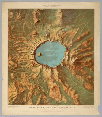
[USGS (U.S. Geological Survey), John H. Renshawe]
Full Title
Panoramic View of the Crater Lake National Park.
Publisher
USGS (U.S. Geological Survey)
Author
[USGS (U.S. Geological Survey), John H. Renshawe]
Full Title
Panoramic View of the Mesa Verde National Park, Colorado.
Publisher
USGS (U.S. Geological Survey)
Author
[USGS (U.S. Geological Survey), John H. Renshawe]
Full Title
Panoramic View of the Yosemite National Park, California.
Publisher
USGS (U.S. Geological Survey)
Author
[USGS (U.S. Geological Survey), John H. Renshawe]
Full Title
Panoramic View of the Rocky Mountain National Park, Colorado.
Publisher
USGS (U.S. Geological Survey)
Author
[USGS (U.S. Geological Survey), John H. Renshawe]
Full Title
Panoramic View of the Mount Rainier National Park, Washington.
Publisher
USGS (U.S. Geological Survey)
Author
[USGS (U.S. Geological Survey), John H. Renshawe]
Full Title
Panoramic View of the Glacier National Park, Montana.
Publisher
USGS (U.S. Geological Survey)
Author
Bulkley, Charles S.
Full Title
Map of Lands of the Saucelito Land and Ferry Company As Laid Out Under The Direction of Chas. S. Bulkley C.E. ; L.H. Shortt ; & S.R. Throckmorton, Jr., engineers ; H.A. Lricks (Alricks), Jr. topographer. Scale, 660 ft. to the inch. Drawn on stone by W. Vallance Gray. G.T. Brown & Co. Print.
Publisher
G.T. Brown & Co.
Author
[Columbia. Comision Corografica, Ponce de Leon, Manuel]
Full Title
Carta corografica del Estado de Panama. Construida con los datos de la Comision Corográfica i de órden del gobierno jeneral por Manuel Ponce de Leon, injeniero i Manuel Maria Paz, Bogota, 1864. Grabada por Erhard Schieble ... 1865. Imprenta Monrocq, Paris. (In upper left margin) "Estados Unidos de Colombia." (In upper right margin) "Publicado bajo la Administración Murillo."
Publisher
[Comision Corografica, Imprenta Monrocq]
Author
Smith, Karl
Full Title
Mississippi the magnolia state. Copyright 1938 by Karl Smith, Cartographer, Louisville, Kentucky.
Publisher
No publisher
Author
Hadol, Paul, 1835-1875
Full Title
Carte drolatique d'Europe pour 1870 ; dressee par Hadol. (title in upper margin) Nouvelle carte d'Europe dressee pour 1870. (dressee par Hadol ) Marehandeau, 505, Rue St Denis. Paris: Imp. Vallee.
Publisher
[Marchandeau, Vallee]
Author
U.S. War Department, Topographical Engineers
Full Title
Department of Oregon. Map of the state of Oregon and Washington Territory, compiled in the Bureau of Topogl. Engrs. chiefly for military purposes by order of Hon. John B. Floyd, Sec. of War. 1859. Engraved by W.H. Dougal.
Publisher
The War Dept.
Author
United States. Alaska Road Commission
Full Title
Map of Alaska By the Alaska Road Commission. 1909. (Upper left sheet) Compiled from Surveys of the Alaska Road Commission, the U.S. Coast and Geodetic Survey, U.S. Geological Survey, U.S. Army Surveys, and the Canadian Geological Survey. Drawn by Jas. H. Watson. C.E. Superintendent A.R.C. Andrew B. Graham Co., lithographers, Washington, D.C. (insets) Aleutian Islands ; (St. Lawrence, Nunivak Island, and Pribilof Islands.)
Publisher
Alaska Road Commission ; Andrew B. Graham Co.
Author
United States. Alaska Road Commission
Full Title
Map of Alaska By the Alaska Road Commission. 1909. (Upper right sheet) Compiled from Surveys of the Alaska Road Commission, the U.S. Coast and Geodetic Survey, U.S. Geological Survey, U.S. Army Surveys, and the Canadian Geological Survey. Drawn by Jas. H. Watson. C.E. Superintendent A.R.C. Andrew B. Graham Co., lithographers, Washington, D.C. (insets) Aleutian Islands ; (St. Lawrence, Nunivak Island, and Pribilof Islands.)
Publisher
Alaska Road Commission ; Andrew B. Graham Co.
Author
United States. Alaska Road Commission
Full Title
Map of Alaska By the Alaska Road Commission. 1909. (Lower left sheet) Compiled from Surveys of the Alaska Road Commission, the U.S. Coast and Geodetic Survey, U.S. Geological Survey, U.S. Army Surveys, and the Canadian Geological Survey. Drawn by Jas. H. Watson. C.E. Superintendent A.R.C. Andrew B. Graham Co., lithographers, Washington, D.C. (insets) Aleutian Islands ; (St. Lawrence, Nunivak Island, and Pribilof Islands.)
Publisher
Alaska Road Commission ; Andrew B. Graham Co.
Author
United States. Alaska Road Commission
Full Title
Map of Alaska By the Alaska Road Commission. 1909. (Lower right sheet) Compiled from Surveys of the Alaska Road Commission, the U.S. Coast and Geodetic Survey, U.S. Geological Survey, U.S. Army Surveys, and the Canadian Geological Survey. Drawn by Jas. H. Watson. C.E. Superintendent A.R.C. Andrew B. Graham Co., lithographers, Washington, D.C. (insets) Aleutian Islands ; (St. Lawrence, Nunivak Island, and Pribilof Islands.)
Publisher
Alaska Road Commission ; Andrew B. Graham Co.
Author
Rude, Klengston
Full Title
Alaska: Far North frontier. Published and distributed by Alaska Arts. Kleng Rude Studio - P.O. Box 1378 Studio City, California. Copyright 1959 R. Klengston Rude Hollywood 38, California.
Publisher
Kleng Rude Studio
Author
Smith, C.
Full Title
Comparative View of the Lengths of the Principal Rivers in the World. London, Published by C. Smith Mapseller No. 172 Strand, Oct. 1st.1817. The Hills &c. by Palmer_The Writing by Gardner.
Publisher
C. Smith
Author
Smith, C.
Full Title
Comparative View of the Heights of the Principal Mountains &c. in the World. London, Published by C. Smith Mapseller, No.172 Strand, Augt. 1st. 1816. Gardner, Sculpt. (Third Edition)
Publisher
C. Smith
Author
Arrowsmith, Aaron
Full Title
(Top Sheet to) To His Royal Highness the Duke of Cambridge, K. G. &c. This Map of the Physical Divisions of Germany, Exhibiting the Post Roads, Canals &c, Constructed from Original Materials, Is with Permission Most humbly Inscribed by His Royal Highness's Faithful & most Devoted Servant, A. Arrowsmith. J. Rowe scrt. & scrulpt. London Published 2nd. Octr. 1812 by A. Arrowsmith Hydrographer to H.R.H. the Prince of Wales, No. 10 Soho Square. Additions & Corrections to Sept. 1816.
Publisher
A. Arrowsmith
Author
Arrowsmith, Aaron
Full Title
(Middle Sheet to) To His Royal Highness the Duke of Cambridge, K. G. &c. This Map of the Physical Divisions of Germany, Exhibiting the Post Roads, Canals &c, Constructed from Original Materials, Is with Permission Most humbly Inscribed by His Royal Highness's Faithful & most Devoted Servant, A. Arrowsmith. J. Rowe scrt. & scrulpt. London Published 2nd. Octr. 1812 by A. Arrowsmith Hydrographer to H.R.H. the Prince of Wales, No. 10 Soho Square. Additions & Corrections to Sept. 1816.
Publisher
A. Arrowsmith
Author
Arrowsmith, Aaron
Full Title
(Bottom Sheet to) To His Royal Highness the Duke of Cambridge, K. G. &c. This Map of the Physical Divisions of Germany, Exhibiting the Post Roads, Canals &c, Constructed from Original Materials, Is with Permission Most humbly Inscribed by His Royal Highness's Faithful & most Devoted Servant, A. Arrowsmith. J. Rowe scrt. & scrulpt. London Published 2nd. Octr. 1812 by A. Arrowsmith Hydrographer to H.R.H. the Prince of Wales, No. 10 Soho Square. Additions & Corrections to Sept. 1816.
Publisher
A. Arrowsmith
Author
[Tardieu, P.A.F., Lapie, Pierre, Piquet, Chles.]
Full Title
A Map of the United States, Canada, New-Scotland, New-Brunswick and New-Foundland ... Carte Des Etats - Unis, Avec Le Canada, la Nouvelle Ecosse, le Nouveau Brunswick & Terre - Neuve. A Map of the West-Indies and the Mexican Gulph (Gulf) ...Carte Des Indes Occientale et du Golfe du Mexique... Dressee par Lapie, Capitaine-Ingenieur-Geographe. Publiee par P.A.F. Tardieu, Gravveur, Editeur-proprietaire, a Paris, Chez P.A.F. Tardieu ....
Publisher
Chez P.A.F. Tardieu
Author
Gill, Leslie MacDonald, 1884-1947
Full Title
The Wonderground Map of London Town. Drawn by MacDonald Gill. Printed and Published by the Westminster Press, 11 Henrietta Street, Covent Garden, London, W.C.
Publisher
Westminster Press
Author
Henry, Everett.
Full Title
Here took place the adventures of Robin Hood and his merry men : from tales of Sherwood Forest. Copyright 1955, Harris-Seybold Company, Cleveland, Ohio. Portrait map by Everett Henry. Litho in U.S. on a Harris offset Press.
Publisher
Harris-Seybold Co.
Author
[George Fielding, Eliot, Thompson, Kenneth, W.]
Full Title
[World War II battlefronts]. Map I, The Russian Front. Copyright, 1944, by Remington Rand, Inc. Printed in U.S.A. (Map signed by) Kenneth W. Thompson. (text signed by) George Fielding Eliot. (on lower margin) X600LB.
Publisher
Remington Rand Inc..
Author
[George Fielding, Eliot, Thompson, Kenneth, W.]
Full Title
[World War II battlefronts]. Map II, The Balkans. Copyright, 1944, by Remington Rand, Inc. Printed in U.S.A. (Map signed by) Kenneth W. Thompson. (text signed by) George Fielding Eliot. (on lower margin) X600LB.
Publisher
Remington Rand Inc..
|