Browse All
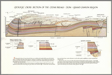
1985 Geologic Cross Section of the Cedar Brea … Separate Map Geologic Cross Section of the Cedar Brea … |

1985 Geologic Cross Section of the Grand Cany … Separate Map Geologic Cross Section of the Grand Cany … |

1948 Routes to Yosemite National Park. Separate Map Routes to Yosemite National Park. Copyri … |

1948 Roads in Yosemite Valley. Routes to Yose … Separate Map Roads in Yosemite Valley. Routes to Yose … |

1930 Bermuda Islands. Separate Map A Map of the Bermuda Islands. Sa des Dem … |

1963 New York City Picture Map. Separate Map New York (City) Picture Map. |

1936 Story Map of Ireland. Separate Map Story Map of Ireland. |

1942 Total War, Battle Map. Separate Map Total War, Battle Map. Designed and Draw … |

1939 World Wonders, A Pictorial Map. Separate Map World Wonders, A Pictorial Map. Designed … |

1949 The pictorial map : United States Stamps Separate Map The pictorial map : United States Stamps … |

1837 Residential Main St. Nantucket Mass. Des … Separate Map Residential Main St. Nantucket Mass. Des … |

1946 World around the United States : Map of … Separate Map World around the United States : Map of … |

1950 The Panorama Today in Northern Californi … Separate Map The Panorama Today in Northern Californi … |

1950 The Panorama Today in Northern Californi … Separate Map The Pageant of History in Northern Calif … |

1939 Map of America's making Separate Map Map of America's making : a chart of pla … |

1962 California and Nevada : Pano-view map Separate Map Pano-view map : California, Nevada. Prog … |

1820 Hohen Charte oder bildlich vergleichende … Separate Map Hohen Charte oder bildlich vergleichende … |

1821 Hohen charte Berge in Teutschland und de … Separate Map Hohen Charte oder bildlich vergleichende … |

1934 San Francisco Bay. (with) part of San Fr … Separate Map San Francisco Bay. (with) part of San Fr … |

1951 London, The Bastion of Liberty. Separate Map London, The Bastion of Liberty. |

1937 Montana. Separate Map Frontier - Montana - Pioneer. A One Page … |

1955 Donner "U.S. 40", Follow the Route of th … Separate Map Donner "U.S. 40", Follow the Route of th … |

1939 New York 1939 Official World's Fair Pict … Separate Map The New York 1939 Official World's Fair … |

1934 Wonder Map of Melbourne. Separate Map The Wonder Map of Melbourne drawn by Joh … |

2002 Lake Tahoe map art mosaic. Separate Map (Lake Tahoe map art mosaic. 2002) |

1956 A map of the missions, presidios, pueblo … Separate Map A map of the missions, presidios, pueblo … |

1954 Outdoor play places of California Separate Map Outdoor play places of California : a ca … |

1952 A Map of the Marked Historical Sites of … Separate Map A Map of the Marked Historical Sites of … |

1851 Map of the United States. Separate Map Map Of The United States From The Latest … |

1836 Map of the State of New Jersey. Separate Map Squire's Map Of The State Of New Jersey. … |

1836 Carte des Tribus Indiennnes de l'Ameriqu … Separate Map Carte des Tribus Indiennnes de l'Ameriqu … |

1914 Imperial Valley tract map Separate Map Imperial Valley tract map. Published by … |

1914 Irrigation district and road map, Imperi … Separate Map Irrigation district and road map, Imperi … |

1940 Tea revives the world. MacDonald Gill 19 … Separate Map Tea. Revives. The. World. MacDonald Gill … |

1991 Silicon Valley. 1991 Separate Map Silicon Valley. 1991. F.A.P. Fine Additi … |

1926 Windsor Farms, a residential development … Separate Map Windsor Farms, a residential development … |

1930 Map of North America. Karte von Nordamer … Separate Map Map of North America. Karte von Nordamer … |

1862 Carte de la Republique du Paraguay : cou … Separate Map Carte de la Republique du Paraguay : cou … |

1861 Carte de la Partie Meridionale de la Rep … Separate Map Carte de la Partie Meridionale de la Rep … |

1861 Carte de la Partie Meridionale de la Rep … Separate Map Carte de la Partie Meridionale de la Rep … |

1995 Road Map to the Best Free Stuff on the I … Separate Map Road Map to the Best Free Stuff on the I … |

1955 Mono County greets you : fisherman's par … Separate Map Mono County greets you : fisherman's par … |

1955 1955 Map and resort directory of Souther … Separate Map (Mono County). 1955 Map and resort direc … |

1933 Being a cartograph of Ohio Separate Map Being a Cartograph of Ohio. The oldest s … |

1949 A map of Yorkshire produced by British R … Separate Map A map of Yorkshire produced by British R … |

1929 A pictorial chart of English literature Separate Map A pictorial chart of English literature. … |

1927 The booklovers' map of the British Isles Separate Map The booklovers' map of the British Isles … |

1926 The map of America's making Separate Map The map of America's making : For those … |

1935 A pictorial map of the British Isles Separate Map A pictorial map of the British Isles : B … |

1938 Europe : A pictorial map, by Ernest Dudl … Separate Map Europe : A pictorial map, by Ernest Dudl … |