Who What Where WhenREMOVEWHEREShow More |
Author
White, M. Wood
Full Title
Wheeling. (with) New Manchester. (with) Benwood. (with) Plan of Buckannon, Upshur County. (with) Moundsville. Entered according to Act of Congress in the year 1873 by M. Wood White in the Office of the Librarian of Congress at Washington.
Publisher
M.W. White
Author
White, M. Wood
Full Title
White's topographical, county & district atlas of West Virginia. Counties of Tyler, Ritchie, Pleas(a)nts, Wood, Wirt. Entered according to Act of Congress in the year 1873 by M. Wood White in the Office of the Librarian of Congress at Washington.
Publisher
M.W. White
Author
White, M. Wood
Full Title
Parkersburg. Entered according to Act of Congress in the year 1873 by M. Wood White in the Office of the Librarian of Congress at Washington.
Publisher
M.W. White
Author
White, M. Wood
Full Title
White's topographical, county & district atlas of West Virginia. Counties of Mason, Jackson, Roane. Entered according to Act of Congress in the year 1873 by M. Wood White in the Office of the Librarian of Congress at Washington.
Publisher
M.W. White
Author
White, M. Wood
Full Title
White's topographical, county & district atlas of West Virginia. Counties of Calhoun, Gilmer, Braxton, Lewis, Upshur. (with) Weston. Entered according to Act of Congress in the year 1873 by M. Wood White in the Office of the Librarian of Congress at Washington.
Publisher
M.W. White
Author
White, M. Wood
Full Title
White's topographical, county & district atlas of West Virginia. Counties of Pocohontas (i.e. Pocahontas), Greenbrier. (with) Lewisburg. Entered according to Act of Congress in the year 1873 by M. Wood White in the Office of the Librarian of Congress at Washington.
Publisher
M.W. White
Author
White, M. Wood
Full Title
White's topographical, county & district atlas of West Virginia. Counties of Clay, Webster, Nicholas, Fayette. Entered according to Act of Congress in the year 1873 by M. Wood White in the Office of the Librarian of Congress at Washington.
Publisher
M.W. White
Author
White, M. Wood
Full Title
City of Charleston, Capitol of West Virginia. 1873.
Publisher
M.W. White
Author
White, M. Wood
Full Title
White's topographical, county & district atlas of West Virginia. Counties of Putnam, Kanawha, Boone. Entered according to Act of Congress in the year 1873 by M. Wood White in the Office of the Librarian of Congress at Washington.
Publisher
M.W. White
Author
White, M. Wood
Full Title
City of Huntington. (with) Clarksburg. (with) Plan of Guyandotte, Cabell County, W. Va. Entered according to Act of Congress in the year 1873 by M. Wood White in the Office of the Librarian of Congress at Washington.
Publisher
M.W. White
Author
White, M. Wood
Full Title
White's topographical, county & district atlas of West Virginia. Counties of Cabell, Wayne, Lincoln, Logan. Entered according to Act of Congress in the year 1873 by M. Wood White in the Office of the Librarian of Congress at Washington.
Publisher
M.W. White
Author
White, M. Wood
Full Title
Plan of Pt. Pleasant, Mason County, W. Va. (with) Wellsburg. (with) Grafton, West Grafton, South Grafton. Entered according to Act of Congress in the year 1873 by M. Wood White in the Office of the Librarian of Congress at Washington.
Publisher
M.W. White
Author
White, M. Wood
Full Title
White's topographical, county & district atlas of West Virginia. Counties of Raleigh, Mercer, Summers, Monroe. (with) Union. (with) Plan of Ronceverte, Greenbrier County. Entered according to Act of Congress in the year 1873 by (M. Wood) White in the Office of the Librarian of Congress at Washington.
Publisher
M.W. White
Author
White, M. Wood
Full Title
White's topographical, county & district atlas of West Virginia. Counties of Wyoming, McDowell. Entered according to Act of Congress in the year 1873 by (M. Wood) White in the Office of the Librarian of Congress at Washington.
Publisher
M.W. White
Author
[Gamble, William H., Mitchell, Samuel Augustus]
Full Title
A new map of Palestine or the Holy Land. (with) Modern Jerusalem. Drawn and engraved by W.H. Gamble, Philada. Entered according to Act of Congress in the year 1872 by S. Augustus Mitchell in the Office of the Librarian of Congress at Washington. (1873)
Publisher
M.W. White
Author
[White, M. Wood, Young, James H.]
Full Title
Map of the Roman Empire at the period of its greatest extent. About the year A.D. 107. Engraved to illustrate Mitchell's ancient geography. (with) Map of Britannia Romanorum of Roman Britain. (with) Map of northern and central Syria. Drawn & engraved by J.H. Young. Entered according to Act of Congress in the year 1844 by S. Augustus Mitchell in the ... District Court of the eastern district of Pennsylvania. (1873)
Publisher
M.W. White
Author
Tyson, Philip T.
Full Title
Map of Maryland and the District of Columbia, colored to illustrate the geological formations by Philip T. Tyson. L.E. Neuman, eng. , 36 Vesey St., N.Y. (Published by Stedman, Brown & Lyon, Baltimore. 1873)
Publisher
Stedman, Brown & Lyon
Author
Blodget, Lorin
Full Title
Climatological map of the State of Maryland and the District of Columbia, by Lorin Blodget, 1873. (Published by Stedman, Brown & Lyon, Baltimore. 1873)
Publisher
Stedman, Brown & Lyon
Author
[Gray, Ormando Willis, Martenet, Simon J., Walling, H. F.]
Full Title
City of Baltimore. (Published by Stedman, Brown & Lyon, Baltimore. 1873)
Publisher
Stedman, Brown & Lyon
Author
[Gray, Ormando Willis, Martenet, Simon J., Walling, H. F.]
Full Title
City of Cumberland, Alleghany Co., Maryland. (Published by Stedman, Brown & Lyon, Baltimore. 1873)
Publisher
Stedman, Brown & Lyon
Author
[Gray, Ormando Willis, Martenet, Simon J., Walling, H. F.]
Full Title
Hagerstown. (with) Annapolis, the state capital. (with) Frederick City. (Published by Stedman, Brown & Lyon, Baltimore. 1873)
Publisher
Stedman, Brown & Lyon
Author
Gray, Frank Arnold
Full Title
New railroad map of the states of Maryland, Delaware, and the District of Columbia. Compiled and drawn by Frank Arnold Gray, 1873. (Published by Stedman, Brown & Lyon, Baltimore. 1873)
Publisher
Stedman, Brown & Lyon
Author
[Gray, Ormando Willis, Martenet, Simon J., Walling, H. F.]
Full Title
Topographical atlas of Maryland: counties of Alleghany and Garrett. (Published by Stedman, Brown & Lyon, Baltimore. 1873)
Publisher
Stedman, Brown & Lyon
Author
[Gray, Ormando Willis, Martenet, Simon J., Walling, H. F.]
Full Title
Topographical atlas of Maryland: County of Washington. (Published by Stedman, Brown & Lyon, Baltimore. 1873)
Publisher
Stedman, Brown & Lyon
Author
[Gray, Ormando Willis, Martenet, Simon J., Walling, H. F.]
Full Title
Topographical atlas of Maryland: counties of Carroll and Frederick. (Published by Stedman, Brown & Lyon, Baltimore. 1873)
Publisher
Stedman, Brown & Lyon
Author
[Gray, Ormando Willis, Martenet, Simon J., Walling, H. F.]
Full Title
Topographical atlas of Maryland: counties of Baltimore and Harford. (Published by Stedman, Brown & Lyon, Baltimore. 1873)
Publisher
Stedman, Brown & Lyon
Author
[Gray, Ormando Willis, Martenet, Simon J., Walling, H. F.]
Full Title
Topographical atlas of Maryland: counties of Cecil and Kent. (Published by Stedman, Brown & Lyon, Baltimore. 1873)
Publisher
Stedman, Brown & Lyon
Author
[Gray, Ormando Willis, Martenet, Simon J., Walling, H. F.]
Full Title
Topographical atlas of Maryland: counties of Howard and Montgomery and the District of Columbia. (Published by Stedman, Brown & Lyon, Baltimore. 1873)
Publisher
Stedman, Brown & Lyon
Author
[Gray, Ormando Willis, Martenet, Simon J., Walling, H. F.]
Full Title
Topographical atlas of Maryland: counties of Anne Arundel and Prince George. (Published by Stedman, Brown & Lyon, Baltimore. 1873)
Publisher
Stedman, Brown & Lyon
Author
[Gray, Ormando Willis, Martenet, Simon J., Walling, H. F.]
Full Title
Topographical atlas of Maryland: counties of Calvert, Charles and St. Marys. (Published by Stedman, Brown & Lyon, Baltimore. 1873)
Publisher
Stedman, Brown & Lyon
Author
[Gray, Ormando Willis, Martenet, Simon J., Walling, H. F.]
Full Title
Topographical atlas of Maryland: counties of Caroline, Queen Anne and Talbot. (Published by Stedman, Brown & Lyon, Baltimore. 1873)
Publisher
Stedman, Brown & Lyon
Author
[Gray, Ormando Willis, Martenet, Simon J., Walling, H. F.]
Full Title
Topographical atlas of Maryland: counties of Dorchester, Wicomico, Somerset and Worcester. (Published by Stedman, Brown & Lyon, Baltimore. 1873)
Publisher
Stedman, Brown & Lyon
Author
[Gray, Ormando Willis, Martenet, Simon J., Walling, H. F.]
Full Title
Map of the District of Columbia including the cities of Washington, Georgetown, and Alexandria, Virginia. 1873. (Published by Stedman, Brown & Lyon, Baltimore. 1873)
Publisher
Stedman, Brown & Lyon
Author
Lloyd, H.H.
Full Title
The world. (by H.H. Lloyd. Published by Stedman, Brown & Lyon, Baltimore. 1873)
Publisher
Stedman, Brown & Lyon
Author
Lloyd, H.H.
Full Title
Map of the United States and territories. Philadelphia, 1872. (by H.H. Lloyd. Published by Stedman, Brown & Lyon, Baltimore. 1873)
Publisher
Stedman, Brown & Lyon
Author
United States Coast Survey
Full Title
North western America showing the territory ceded by Russia to the United States. Reduced from the map published by the U.S.C.S. Dept. (Published by Stedman, Brown & Lyon, Baltimore. 1873)
Publisher
Stedman, Brown & Lyon
Author
Lloyd, H.H.
Full Title
Atlas of the United States. New England and New York. (by H.H. Lloyd. Published by Stedman, Brown & Lyon, Baltimore. 1873)
Publisher
Stedman, Brown & Lyon
Author
Lloyd, H.H.
Full Title
Atlas of the United States. Delaware, Illinois, Indiana, Iowa, Kentucky, Maryland, Missouri, New Jersey, North Carolina, Ohio, Pennsylvania, Tennessee, Virginia and West Virginia. (by H.H. Lloyd. Published by Stedman, Brown & Lyon, Baltimore. 1873)
Publisher
Stedman, Brown & Lyon
Author
Lloyd, H.H.
Full Title
Atlas of the United States. Michigan, Minnesota, and Wisconsin. (by H.H. Lloyd. Published by Stedman, Brown & Lyon, Baltimore. 1873)
Publisher
Stedman, Brown & Lyon
Author
Lloyd, H.H.
Full Title
Atlas of the United States. Oregon, and the Territory of Washington. (by H.H. Lloyd. Published by Stedman, Brown & Lyon, Baltimore. 1873)
Publisher
Stedman, Brown & Lyon
Author
Lloyd, H.H.
Full Title
Atlas of the United States. Nebraska, and the territories of Dakota, Idaho, Montana and Wyoming. (by H.H. Lloyd. Published by Stedman, Brown & Lyon, Baltimore. 1873)
Publisher
Stedman, Brown & Lyon
Author
Lloyd, H.H.
Full Title
Atlas of the United States. California and Nevada. (by H.H. Lloyd. Published by Stedman, Brown & Lyon, Baltimore. 1873)
Publisher
Stedman, Brown & Lyon
Author
Lloyd, H.H.
Full Title
Atlas of the United States. Texas. (by H.H. Lloyd. Published by Stedman, Brown & Lyon, Baltimore. 1873)
Publisher
Stedman, Brown & Lyon
Author
Lloyd, H.H.
Full Title
Atlas of the United States. Kansas, and the territories of Arizona, Colorado, New Mexico, Utah, and Indian Territory. (by H.H. Lloyd. Published by Stedman, Brown & Lyon, Baltimore. 1873)
Publisher
Stedman, Brown & Lyon
Author
Lloyd, H.H.
Full Title
Atlas of the United States. Alabama, Arkansas, Louisiana, and Mississippi. (by H.H. Lloyd. Published by Stedman, Brown & Lyon, Baltimore. 1873)
Publisher
Stedman, Brown & Lyon
Author
Lloyd, H.H.
Full Title
Atlas of the United States. Florida, Georgia, and South Carolina. (by H.H. Lloyd. Published by Stedman, Brown & Lyon, Baltimore. 1873)
Publisher
Stedman, Brown & Lyon
Author
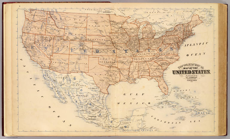
Andreas, A. T. (Alfred Theodore), 1839-1900
Full Title
Topographical map of the United States. Published by A.T. Andreas, Lakeside Building, Chicago, 1873. (Chas. Shober & Co. Proprietors of Chicago Lith. Co.)
Publisher
A.T. Andreas
Author
[Beers, J.B. & Co., H.W. Burgett and Company]
Full Title
City of Burlington, Chittenden Co., Vt., 1873. (Published by H.W. Burgett & Co. 36 Vesey Street, New-York. 1876. Entered ... 1876 by H.W. Burgett & Co. ... Washington D.C. Engraved & printed by J.B. Beers & Co. 36 Vesey St. N.Y.)
Publisher
H.W. Burgett & Co.
|