|
Author
[Bowen, William A., Brand, Stewart, California Department of Water Resources, California Governor's Office of Planning and Research, Fuller, David L., Kahrl, William L., Ryan, Donald A., Shelton, Marlyn L.]
Full Title
State Water Project. Water Year 1975. Chapter 6. The Great Valley Systems (continued).
Publisher
State of California
Author
[Bowen, William A., Brand, Stewart, California Department of Water Resources, California Governor's Office of Planning and Research, Fuller, David L., Kahrl, William L., Ryan, Donald A., Shelton, Marlyn L.]
Full Title
Chapter 6. The Great Valley Systems (continued). Applied Irrigation Water 1972.
Publisher
State of California
Author
[Bowen, William A., Brand, Stewart, California Department of Water Resources, California Governor's Office of Planning and Research, Fuller, David L., Kahrl, William L., Ryan, Donald A., Shelton, Marlyn L.]
Full Title
Chapter 7. The Operation of the Modern Water System. Principal Lakes and Reservoirs.
Publisher
State of California
Author
[Bowen, William A., Brand, Stewart, California Department of Water Resources, California Governor's Office of Planning and Research, Fuller, David L., Kahrl, William L., Ryan, Donald A., Shelton, Marlyn L.]
Full Title
Measured and Unimpaired Streamflows. Water Year 1975.
Publisher
State of California
Author
[Brand, Stewart, California Department of Water Resources, California Governor's Office of Planning and Research, Fuller, David L., Kahrl, William L., Ryan, Donald A., Shelton, Marlyn L., Bowen, William A.]
Full Title
Groundwater. Chapter 7. The Operation of the Modern Water System (continued).
Publisher
State of California
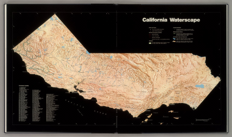
Author
[Bowen, William A., Brand, Stewart, California Department of Water Resources, California Governor's Office of Planning and Research, Fuller, David L., Kahrl, William L., Ryan, Donald A., Shelton, Marlyn L.]
Full Title
California Waterscape.
Publisher
State of California
Author
[Bowen, William A., Brand, Stewart, California Department of Water Resources, California Governor's Office of Planning and Research, Fuller, David L., Kahrl, William L., Ryan, Donald A., Shelton, Marlyn L.]
Full Title
Drought. Water Years 1976/1977. Chapter 7. The Operation of the Modern Water System (continued).
Publisher
State of California
Author
[Bowen, William A., Brand, Stewart, California Department of Water Resources, California Governor's Office of Planning and Research, Fuller, David L., Kahrl, William L., Ryan, Donald A., Shelton, Marlyn L.]
Full Title
Urban Water Use and Price. Chapter 8. The Economics of Water (continued).
Publisher
State of California
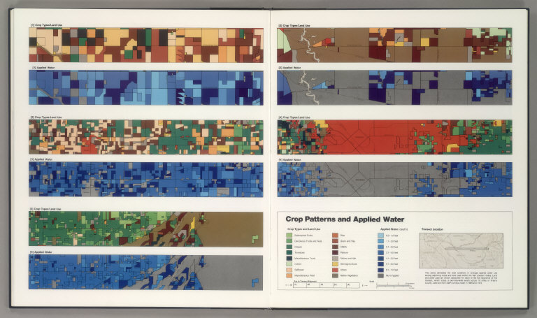
Author
[Bowen, William A., Brand, Stewart, California Department of Water Resources, California Governor's Office of Planning and Research, Fuller, David L., Kahrl, William L., Ryan, Donald A., Shelton, Marlyn L.]
Full Title
Crop Patterns and Applied Water.
Publisher
State of California
Author
[Bowen, William A., Brand, Stewart, California Department of Water Resources, California Governor's Office of Planning and Research, Fuller, David L., Kahrl, William L., Ryan, Donald A., Shelton, Marlyn L.]
Full Title
Chapter 9. Commercial and Recreational Water Use (continued). Hydroelectric Power Generation. Facilities, Installed Capacities, and Load Factors, 1972.
Publisher
State of California
Author
[Bowen, William A., Brand, Stewart, California Department of Water Resources, California Governor's Office of Planning and Research, Fuller, David L., Kahrl, William L., Ryan, Donald A., Shelton, Marlyn L.]
Full Title
Surface Water Quality, Water Year 1975.
Publisher
State of California
Author
[Bowen, William A., Brand, Stewart, California Department of Water Resources, California Governor's Office of Planning and Research, Fuller, David L., Kahrl, William L., Ryan, Donald A., Shelton, Marlyn L.]
Full Title
Chapter 10. Water Quality (continued). Sewage Treatment Facilities. Capacities, Treatment Standards & Volumes, 1975.
Publisher
State of California
Author
[Bowen, William A., Brand, Stewart, California Department of Water Resources, California Governor's Office of Planning and Research, Fuller, David L., Kahrl, William L., Ryan, Donald A., Shelton, Marlyn L.]
Full Title
Chapter 11. Unresolved Questions for the Future (continued). San Francisco Bay and the Delta.
Publisher
State of California
Author
[Bowen, William A., Brand, Stewart, California Department of Water Resources, California Governor's Office of Planning and Research, Fuller, David L., Kahrl, William L., Ryan, Donald A., Shelton, Marlyn L.]
Full Title
Chapter 11. Unresolved Questions for the Future (continued).
Publisher
State of California
Author
Colton, G.W.
Full Title
Comparative Size of Lakes and Islands. Lakes in the Western Hemisphere. Lakes in the Eastern Hemisphere. Islands in the Western Hemisphere. Islands in the Eastern Hemisphere. Published by J. H. Colton. No. 172 William St. New York.
Publisher
J. H. Colton.
Author
Colton, G.W.
Full Title
Map of the World Illustrating the Principal Features of The Land and the Co-Tidal Lines. Map of the World Illustrating the Principal Features of Meteorology. Map of the World Showing the Geographical Distribution and Range of the Principal Members of Animal Kingdom. Map of the World Showing the Principal Ocean Currents and Boundaries of River Systems. Map of the World Showing the Distribution and Limits of Cultivation of the Principal Plants Useful to Mankind. Map of the World illustrating the Productive Industry of Various Countries & Exhibiting the Principal Features of Commerce and Navigation. Published by J. H. Colton. No. 172 William St. New York.
Publisher
J. H. Colton.
Author
Colton, G.W.
Full Title
Comparative Size of Lakes and Islands. Lakes in the Western Hemisphere. Lakes in the Eastern Hemisphere. Islands in the Western Hemisphere. Islands in the Eastern Hemisphere. Published by G. W & C. B. Colton & Co., No. 172 William St. New York.
Publisher
G. W & C. B. Colton & Co.
Author
Colton, G.W.
Full Title
Map of the World Illustrating the Principal Features of The Land and the Co-Tidal Lines. Map of the World Illustrating the Principal Features of Meteorology. Map of the World Showing the Geographical Distribution and Range of the Principal Members of Animal Kingdom. Map of the World Showing the Principal Ocean Currents and Boundaries of River Systems. Map of the World Showing the Distribution and Limits of Cultivation of the Principal Plants Useful to Mankind. Map of the World illustrating the Productive Industry of Various Countries & Exhibiting the Principal Features of Commerce and Navigation. Published by G. W & C. B. Colton & Co., No. 172 William St. New York.
Publisher
G. W & C. B. Colton & Co.
Author
Johnson, A.J.
Full Title
Johnson's Map of The World Showing the Geographical Distribution & Range of The Principal Members of The Animal Kingdom (with) Bird Map. Johnson's Map of The World Illustrating the Productive Industry Of Various Countries, & exhibiting the principal features of Commerce And Navigation. Johnson's Map Showing the Principal Ocean Currents and Boundaries of the River Systems. Johnson's Map Illustrating the Principal Features of Meteorology (with) Rain Map. Johnson's Map Illustrating the Principal Features of the Land and the Co-tidal Lines. Johnson's Map Showing the Distribution and Limits of Cultivation of the Principal Plants Useful to Mankind.
Publisher
Johnson and Ward
Author
Lange, Henry, 1821-1893.
Full Title
Verbreitung u. vertheilung der Saugethiere (Mammalia) in Nord Amerika. (with 3 inset maps) Vergleichende Uebersicht der in Nord-Amerika einheimischen Familien der Land Saugethiere. H. Lange's Atlas v. Nord Amerika Blatt XVI. Braunschweig: Verlag v. George Westermann. Lith. Anst. von L. Kraatz in Berlin.
Publisher
George Westermann.
Author
Lange, Henry, 1821-1893.
Full Title
Verbreitung der nahrungs- und kleidungsstoffe liefernden Pflanzen etc. in Nord Amerika. H. Lange's Atlas v. Nord Amerika Blatt XVII. Braunschweig: Verlag v. George Westermann. Lith. Anst. von L. Kraatz in Berlin.
Publisher
George Westermann.
Author
Snyder, Van Vechten & Co.
Full Title
Map of Wisconsin showing congressional and judicial districts. Copyright 1877 by Snyder, Van Vechten & Co. (Compiled and published by Snyder, Van Vechten & Co., Milwaukee. 1878)
Publisher
Snyder, Van Vechten & Co.
Author
Snyder, Van Vechten & Co.
Full Title
Map of Wisconsin showing senatorial districts. Copyright 1877 by Snyder, Van Vechten & Co. (Compiled and published by Snyder, Van Vechten & Co., Milwaukee. 1878)
Publisher
Snyder, Van Vechten & Co.
Author
Snyder, Van Vechten & Co.
Full Title
Map of Wisconsin, showing assembly districts. Copyright 1877, by Snyder, Van Vechten & Co. (Published by Snyder, Van Vechten & Co., Milwaukee. 1878)
Publisher
Snyder, Van Vechten & Co.
|