Who What Where WhenREMOVEWHO
WHEN
|
Author
Andreas, A. T. (Alfred Theodore), 1839-1900
Full Title
(Title Page to) A.T. Andreas' illustrated historical atlas of the State of Iowa. 1875. (7th Congressional District ed.). (with view:) State Capitol, Des Moines. Published by the Andreas Atlas Co., Lakeside Building, Chicago, Ills. Engraved & printed by Chas. Shober & Co., Props. of Chicago Lithographing Co.
Publisher
Andreas Atlas Co.
Author
Bridgens, H.F.
Full Title
(Title Page) Bridgens' Atlas Of Lancaster Co., Penna. From actual Surveys by H.F. Bridgens and Assistants, Published By D.S. Bare, Lancaster, Pa. Engraved & Printed at Jas. McGuigan's Lithc. Estabnt. S.E. Cor. Third & Dock Sts. Philada. Entered ... 1864, by H.F. Bridgens ... Penna.
Publisher
D.S. Bare
Author
[Sanford, E.F., Everts, W.P.]
Full Title
(Title Page to) Atlas And History Of Androscoggin County, Maine. From actual Surveys, drawn and Published By Sanford Everts & Co. 31 South Sixth Street, Philadelphia, 1873. E.F. Sanford, W.P. Everts. Assistants: C.T. Leggett, Jas. A. Edgerly, J.D. Wolcott, A. Landon, N. Geo. Colby, J.P. Edwards, C.H. Edwards, A.H. Harlow, A.D. Roe. Entered ... 1873 by Sanford & Everts ... Washington. Printed by Fred. Bourquin, 29 & 31 So. 6th St. Phila. Engd. by Worley & Bracher, 31 So. Sixth St. Phila.
Publisher
Sanford Everts & Co.
Author
[Roe, F.B., Colby, N. Geo.]
Full Title
(Title Page) Atlas Of Saint John City And County, New Brunswick. Compiled and Drawn From Official Plans and Actual Surveys By F.B. Roe & N. Geo. Colby. Assisted By J.C. Allison And Others, Published By Roe & Colby, St. John N.B. 1875. Engd. by Worley & Bracher, 31 South Sixth St. Philada. Printed by F. Bourquin, 31 South Sixth St. Philada.
Publisher
Roe & Colby
Author
[Lloyd, H.H., Warner & Beers]
Full Title
(Title Page to) Atlas of Whiteside Co. and the State of Illinois To Which Is Added An Atlas Of The United States, Maps of The Hemispheres &c. &c. &c. Warner & Beers. Publishers 62 & 64 West Lake Street, Chicago. 1872. Union Lith. & Printg. Co. Chicago. Assistants: Jos. H. Cox, W.H. Bishop, G.R. Hoffman, L.W. Wight, A.D. Miner, E.C. Moore ... H.R. Belden, John I. Moore, Chas. H. Sharp, R.T. Higgins, Wm. H. Beers, Frank W. Rorh. Entered ... 1872 by Warner & Beers ... Washington D.C.
Publisher
Warner & Beers
Author
U.S. General Land Office
Full Title
(Title Page to) Report of the Commissioner of General Land Office, for the Year 1867. Abridged and published by order of the Senate of the United States. Washington: Government Printing Office. 1867.
Publisher
Government Printing Office
Author
Missouri Publishing Company
Full Title
(Title Page) Atlas Map Of Leavenworth County Kansas. Published By Missouri Publishing Company, 1878.
Publisher
Missouri Publishing Company
Author
McDonough, Leo & Co.
Full Title
(Title Page to) An Illustrated Historical Atlas Map Of Daviess County, Ky. Carefully Compiled from Personal Examinations and Surveys. Published by Leo McDonough & Co. 1876.
Publisher
Leo McDonough & Co.
Author
Beers, D.G.
Full Title
(Title Page) Atlas Of Franklin County Pennsylvania From actual Surveys under the direction of D.G. Beers. Published by Pomeroy & Beers, 320 Chestnut Street, Philadelphia. 1868. Engraved by Worley & Bracher, 320 Chestnut St. Phila. Printed by Fred. Bourquin, 320 Chestnut St. Phila. Entered ... 1867 by Pomeroy & Beers ... Pennsylvania.
Publisher
Pomeroy & Beers
Author
Asher & Adams
Full Title
(Title Page to) Asher & Adams' New Topographical Atlas And Gazetteer Of New York, Comprising A Topographical View Of The Several Counties Of The State ... Including a Fine Copper Plate Railroad Map of the United States And Territories, Drawn on the Polyconic Projection, Expressly for this Work. Compiled From The Latest Astronomical Observations, Official Surveys And Records Of The United States And Territories, And The Several States, As Well As From Counties, Towns And Personal Observations. Engraved on Copper Plate, and Lithographed from Original Drawings. New York: Asher & Adams, 335 Broadway, Indianapolis, Ind. Asher, Adams & Higgins.
Publisher
Asher & Adams
Author
Andreas, A. T. (Alfred Theodore), 1839-1900
Full Title
(Title Page to) An illustrated historical atlas of the State of Minnesota. (with view:) Lake Emily, Le Sueur Co., Minn. near St. Peter. Published by A.T. Andreas, Lakeside Building, Chicago, Ills. 1874. Chas. Shober & Co. Proprietors of Chicago Lith. Co.
Publisher
A.T. Andreas
Author
U.S. Coast Survey
Full Title
(Title Page to) Part of Henrico County Virginia from Smith's Map in the collection of the U.S. Coast Survey Office. (Another title below) Part of Henrico County from Smith's Map of Virginia with additions of Topography from Surveys made under the direction of Genl A.A. Humphreys, Chief Topl Engr. Army of Potomac. Photographed at the U.S. Coast Survey Office July 1862. (title on verso) Map of Part of Henrico County Virga. ...
Publisher
U.S. Coast Survey
Author
[Vorzet, Ed.Dumas, Le Comte de Paris]
Full Title
(Covers and Title Page to) Histoire de la Guerre Civile en Amerique par M. Le Comte de Paris, Ancien Aide de Camp du General Mac Clellan (McClellan). ... Paris. Michel Levy Freres, Editeurs, Rue Auber, 3, Place de L'Opera. Librairie Novelle, Boulevard des Italiens, 15 au Coin de la Rue de Grammont, M DCCC LXXIV, Tous droits reserves. Premiere et Deuxieme Livraisons Contenant Les Planchers I a IX.
Publisher
Michel Levy Freres
Author
[Vorzet, Ed.Dumas, Le Comte de Paris]
Full Title
(Cover #2 to) Histoire de la Guerre Civile en Amerique par M. Le Comte de Paris, Ancien Aide de Camp du General Mac Clellan (McClellan). ... Paris. Michel Levy Freres, Editeurs, Rue Auber, 3, Place de L'Opera. Librairie Novelle, Boulevard des Italiens, 15 au Coin de la Rue de Grammont, M DCCC LXXV, Tous droits reserves. Troisieme et Quatrieme Livraisons Contenant Les Planchers X a XIX.
Publisher
Michel Levy Freres
Author
[Howe, Samuel Gridley, Ruggles, Samuel P.]
Full Title
(Title Page) atlas of the united states, Printed for the use of the blind, at the expense of John C. Cray; under the direction of s.g. howe. at the n.e. institution for the education of the blind. boston 1837.
Publisher
New England Institution for the Education of the Blind
Author
Whitney, J.D.
Full Title
(Title Page) The Yosemite Book; A Description of the Yosemite Valley and the Adjacent Region of the Sierra Nevada, and of the Big Trees of California, Illustrated by Maps and Photographs. Geological Survey of California. J.D. Whitney, State Geologist. Published by Authority of the Legislature. New York, Julius Bien. 1868.
Publisher
Julius Bien
Author
[California Geological Survey, Whitney, J.D.]
Full Title
(Title Page) The Yosemite Guide-Book: A Description of the Yosemite Valley and the Adjacent Region of the Sierra Nevada, and of the Big Trees of California, Illustrated With Maps and Woodcuts. Geological Survey of California. J.D. Whitney, State Geologist. Published by Authority of the Legislature. 1869.
Publisher
University Press
Author
[California Geological Survey, Whitney, J.D]
Full Title
(Title Page) The Yosemite Guide-Book: A Description of the Yosemite Valley and the Adjacent Region of the Sierra Nevada, and of the Big Trees of California, Illustrated With Maps and Woodcuts. Geological Survey of California. J.D. Whitney, State Geologist. Published by Authority of the Legislature. 1870.
Publisher
University Press
Author
[California Geological Survey, Whitney, J.D.]
Full Title
(Title Page to) The Yosemite Guide-Book: A Description of the Yosemite Valley and the Adjacent Region of the Sierra Nevada, and of the Big Trees of California. New Edition, Revised and Corrected. With Four Maps. Geological Survey of California. J.D. Whitney, State Geologist. Published by Authority of the Legislature. 1874.
Publisher
University Press
Author
[California Geological Survey, Whitney, J.D.]
Full Title
(Title Page to) The Yosemite Guide-Book: A Description of the Yosemite Valley and the Adjacent Region of the Sierra Nevada, and of the Big Trees of California. With Two Maps. Geological Survey of California. J.D. Whitney, State Geologist. Published by Authority of the Legislature. 1871.
Publisher
University Press
Author
Nichols, Beach
Full Title
(Title Page) Atlas Of Montgomery And Fulton Counties, New York. From actual Surveys by and under the direction of B. Nichols. Assisted by H.B. Stranahan, W.A. Sherman, H. Loomer, P.A. Cunningham And S.W. Fosdick. Published By J. Jay Stranahan & Beach Nichols, 95 Maiden Lane, New York. 1868. Assistants, W.W. Richie, E.J. Sherwood. Assistants, T. Guernsey, N. Vroman. Entered ... Stranahan & Nichols in the year 1868 ... New York.
Publisher
Stranahan & Nichols
Author
Nichols, Beach
Full Title
(Title Page) Atlas Of Schuyler County, New York. From actual Surveys by and under the direction of Beach Nichols, Published by Pomeroy, Whitman & Co. 31 So. Sixth St. Philadelphia, 1874. Entered ... 1874 by A. Pomeroy & Co. ... Washington. Engd. by Worley & Bracher, 31 So. Sixth St. Philada. Printed by F. Bourquin, 31 So. Sixth St. Philada.
Publisher
Pomeroy, Whitman & Co.
Author
Beers, F.W. (Frederick W.)
Full Title
(Title Page) Atlas Of Rutland Co. Vermont. From actual Surveys by and under the direction of F.W. Beers, assisted by F.W. Fulmer & others. Published By F.W. Beers, A.D. Ellis & G.G. Soule, 95 Maiden Lane, New York. 1869. Assistants W.T. Comstock, A.M., H.D. Whitman, A.J. Bingham, G.H. Jones. Entered ... 1869 by Beers, Ellis & Soule ... New York. Engd. by Worley & Bracher, 320 Chestnut St. Philada. Printed by James McGuigan, Cor. 3d & Dock Sts. Phila.
Publisher
Beers, Ellis & Soule
Author
Everts, Ensign & Everts
Full Title
(Title Page) Combination Atlas Map Of Yates County New York. Compiled, Drawn and Published From Personal Examinations and Surveys. Everts, Ensign & Everts, 714 & 716 Filbert St. Philadelphia. 1876. Thos. Hunter Pr. Phila. N. Friend, Engr. Philad. C.L. Smith, Del.
Publisher
Everts, Ensign & Everts
Author
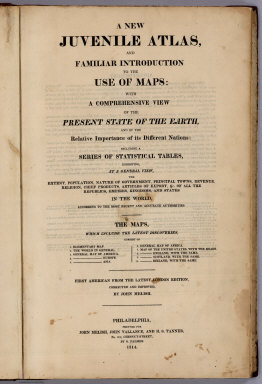
Melish, John
Full Title
(Title Page to) A New Juvenile Atlas, And Familiar Introduction To The Use Of Maps: With A Comprehensive View Of The Present State Of The Earth ... First American From The Latest London Edition, Corrected And Improved, By John Melish. Philadelphia, Printed For John Melish, John Vallance, And H.S. Tanner, No. 209, Chestnut-Street, By G. Palmer. 1814.
Publisher
G. Palmer
Author
Woodbridge, William C.
Full Title
(Title page to) Modern Atlas On A New Plan; To Accompany The System Of Universal Geography, By William Channing Woodbridge. Exhibiting In Connexion With The Outlines Of Countries, The Prevailing Religions, Forms Of Government, And Degrees Of Civilization; The Comparative Size Of Towns, Rivers And Mountains, And The Climates and Productions of the Earth ... London: Published For The Proprietors, By Geo. B. Whittaker, Ave-Maria-Lane. 1828. (on verso) London: Printed By Thomas Davison, Whitefriars.
Publisher
Geo. B. Whittaker
Author
Woodbridge, William C.
Full Title
(Title Page to) A System of Universal Geography, On The Principles of Comparison and Classification; By William Channing Woodbridge ... Illustrated With Maps and Engravings; And Accompanied by an Atlas ... (with) Ancient Geography, As Connected With Chronology, And Preparatory to the Study of Ancient History: By Emma Willard ... Hartford: Oliver D. Cooke & Sons. 1824. (on verso) ... on the eleventh day of June ... (1824) ... William C. Woodbridge ... and Emma Willard ... have deposited ... a Book ... Connecticut.
Publisher
Oliver D. Cooke & Sons
Author
Willard, Emma
Full Title
(Title Page to) Ancient Geography, As Connected With Chronology, And Preparatory to the Study of Ancient History: By Emma Willard ... Hartford: Oliver D. Cooke & Sons. 1824. (on verso) ... on the eleventh day of June ... (1824). (with) A System of Universal Geography, On The Principles of Comparison and Classification; By William Channing Woodbridge ... Illustrated With Maps and Engravings; And Accompanied by an Atlas ... William C. Woodbridge ... and Emma Willard ... have deposited ... a Book ... Connecticut.
Publisher
Oliver D. Cooke & Sons
Author
Page, H.R. & Co.
Full Title
(Title Page to) Illustrated Atlas Of Cedar County Iowa. Containing Maps of Every Township in the County, with Village and City Plats. Also Maps Of Michigan, Indiana, Ohio, Illinois, Wisconsin, Minnesota, Iowa, Missouri, Dakota, Nebraska, Kansas, Montana, Colorado, New Mexico, Arizona, Texas, and Washington Territory. Compiled from Late and Authentic Sources, Together with Other Valuable Information. Published By H.R. Page & Co. Chicago.
Publisher
H.R. Page & Co.
Author
Woodbridge, William C.
Full Title
(Title Page to) Modern Atlas, Physical, Political And Statistical; Exhibiting On Separate Maps, The Physical And Political Characteristics Of Countries, The Prevailing Religions, Forms Of Government And Degrees Of Civilization, The Climates And Productions Of The Earth, And The Comparative Size Of Countries, Towns, Rivers And Mountains; Accompanied By Geographical And Statistical Tables. By William C. Woodbridge ... Entered ... 1843, by W.C. Woodbridge ... Massachusetts. Hartford. Published By Belknap And Hamersley.
Publisher
Belknap and Hamersley
Author
Johnson, A.J.
Full Title
(Title Page to) Johnson's New Illustrated Family Atlas Of The World, Was Awarded The First Prize Medal At The Universal Exposition Of 1867, In Paris, With A Treatise On Physical Geography, By A. Guyot, LL.D. ... With Descriptions, Geographical, Statistical, And Historical ... A Dictionary Of Religious Denominations, Sects, Parties, And Associations, Compiled By Professor Roswell D. Hitchcock, D.D. ... New York: A.J. Johnson, Publisher, 276 & 278 Mulberry Street. 1870. Entered ... One Thousand Eight Hundred and Seventy, by A.J. Johnson ... New York.
Publisher
A.J. Johnson
Author
[Walling, H.F., Hitchcock, C.H.]
Full Title
(Title Page to) Atlas Of The State Of New Hampshire Including Statistics And Descriptions Of Its Topography, Geology, River Systems, Climatology, Railroads, Educational Institutions, Agricultural And Botanical Productions, Mechanical And Manufacturing Interests, Etc. The Topographical Work Under THe Direction Of H.F. Walling, C.E. ... The Descritive Matter Compiled And Edited By Charles H. Hitchcock, Ph.D. ... Published By Comstock & Cline, 27 Warren Street, New York.
Publisher
Comstock & Cline (Bien)
Author
Beers, D. G.
Full Title
(Title Page to) Atlas Of Steuben County, New York. From actual Surveys and Official Records Compiled & Published By D.G. Beers & Co. 31 So. Sixth St. Philadelphia. 1873. D.G. Beers. W.C. Kewen. W. Upton. Entered ... 1873 by D.G. Beers & Co. ... Washington D.C. Engraved by Worley & Bracher, 31 S. 6th St. Phila. Printed by Fred. Bourquin, 31 S. 6th St. Phila. Entered ... 1873 by D.G. Beers & Co. ... Washington D.C.
Publisher
D.G. Beers & Co.
Author
Beers, Frederick W.
Full Title
(Title Page) [facsimile] Atlas Of Cumberland County, Maine. From actual Surveys by and under the Direction of F.W. Beers. Assisted by Geo. P. Sanford and Others, Published by F.W. Beers & Co. 93 & 95 Maiden Lane, New York. 1871. Entered ... 1871 by F.W. Beers & Co. ... Washington. Chas. Hart Lithographer, 99 Fulton St. N.Y. Louis E. Neuman Engraver, 95 Maiden Lane N.Y.
Publisher
F.W. Beers & Co.
Author
[Beers, J.B. & Co., H.W. Burgett and Company]
Full Title
(Title Page to) Illustrated topographical and historical atlas of the State of Vermont. (with view:) State House, Montpelier, Vt. Published by H.W. Burgett & Co. 36 Vesey Street, New-York. 1876. Entered ... 1876 by H.W. Burgett & Co. ... Washington D.C. Engraved & printed by J.B. Beers & Co. 36 Vesey St. N.Y.
Publisher
H.W. Burgett & Co.
Author
Vancouver, George, 1757-1798
Full Title
(Title Page to) A Voyage Of Discovery To The North Pacific Ocean And Round The World In Which The Coast of North-West America Has Been Carefully Examined And Accurately Surveyed. Undertaken by His Majesty's Command, Principally With A View To Ascertain The Existence Of Any Navigable Communication Between The North Pacific and North Atlantic Oceans; And Performed In The Years 1790, 1791, 1792, 1793, 1794, and 1795 In The Discovery Sloop Of War, And Armed Tender Chatham, Under The Command Of Captain George Vancouver. In Three Volumes. London: Printed For G.G. And J. Robinson, Paternoster-Row; And J. Edwards, Pall-Mall. 1798.
Publisher
G.G. & J. Robinson
Author
Howland, H.G.
Full Title
(Title Page) Atlas Of Auglaize County Ohio From Records & Original Surveys. Drawn & Compiled By H.G. Howland, C.E. Illustrations By H.G. Howland & A. Keller. Published By Robt. Sutton, Philadelphia. 1880. Assistants. R.M. Zuver, S.H. Royce, A.W. Campbell ... A.H. Sanborn, R.S.McCartney. Engraved by Wm. Bracher, 27 So. Sixth St. Phila. Oldach & Mergenthaler, Binders Philad. Printed by F. Bourquin, 31 So. Sixth St. Phil.
Publisher
Robert Sutton
Author
Hopkins, G.M.
Full Title
(Title Page to) Atlas Of The County Of Montgomery and the State of Pennsylvania From actual surveys & official records, Compiled & Published By G.M. Hopkins & Co. 320 Walnut St, Philadelphia. 1871. Assistant Surveyors: H.W. Hopkins, W.S. MacCormac, Edward Vansciver, Weston R. Smith, Samuel Huff, Robert Foust, L. Cunningham. Assistant Publishers: Richard Clark, M.S. Converse, S.T.C. Bell, L.J. Richards, J.C. Martin, W.G. Carter, Isaac Borneman, James Wilson, A.R. Whipple. Engraved by Edward Busch, 320 Walnut St. F. Bourquin Lith 104 Hudson St. Phila. Entered ... 1871, by G.M. Hopkins ... Washington, D.C.
Publisher
G.M. Hopkins & Co.
Author
Brink, McCormick & Co.
Full Title
(Title Page) Illustrated Atlas Map of Montgomery County, Ill. Carefully Compiles from Personal Examinations and Surveys. 1874. Published by Brink, McCormick & Co., of Illinois. Duval & Hunter, Lithographers, Philada, Pa. (Portrait) Gen. Jesse J. Chillips.
Publisher
Brink, McCormick & Co.
Author
[Beers, S.N., Beers, D.G.]
Full Title
(Title Page to) New Topographical Atlas of Jefferson Co. New York From Actual Surveys By S.N. & D.G. Beers And Assistants. C.K. Stone, Publisher, Philadelphia. 1864. Entered ... 1864 by C.K. Stone ... Pennsylvania.
Publisher
C.K. Stone
Author
Ruhle von Lilienstern, August
Full Title
(Title Page) Allgemeiner Schulatlas v. R v. L. Berlin, 1825.
Publisher
C.G. Luderitz
Author
Lake, D.J.
Full Title
(Title Page) Atlas Of Wayne Co. Indiana From actual Surveys by D.J. Lake, C.E. assisted by G.P. Sanford & F.A. Gould. To which is added A Map Of The State Of Indiana also An Outline And Rail Road Map Of The United States. Assistant, A. Hall. Published by Griffing, Stevenson & Co. 31 South 6th St. Philadelphia. 1874. Eng'd. by Worley & Bracher, 31 So. 6th St. Philadelphia. Printed by Fred. Bourquin, 31 South 6th St. Philada.
Publisher
Griffing, Stevenson & Co.
Author
Morse, Sidney E.
Full Title
(Covers to) The Cerographic Missionary Atlas. Published By Sidney E. Morse & Co., Gratuitously and Exclusively For The Subscribers To The New York Observer. (on verso) Entered .. 1848, By S.E. Morse & Co. ... New York.
Publisher
Sidney E. Morse
Author
Geological Survey (U.S.)
Full Title
(Title Page to) Topographical atlas of the state of Rhode Island and Providence Plantations, by the United States Geological Survey, in cooperation with the state. 1891. U.S. Geological Survey. J.W. Powell, Director. Henry Gannett, Chief Geographer. Marcus Baker, geographer in charge. State of Rhode Island. David W. Hoyt, John W. Ellis, Winslow Upton, commissioners. Triangulation and topography by the U.S. Geological and the U.S. Coast & Geodetic surveys. Surveyed 1885-1888. For sale by J.C. Thompson, 269 Westminster St., Providence, R.I. Under the direction of the commission. (Printed by) Geo. H. Walker & Co., Boston & N.Y.
Publisher
J.C. Thompson
Author
D.H. Hurd & Co.
Full Title
(Title Page to) Town and city atlas of the state of Connecticut. Compiled from government surveys, county records and personal investigations. D.H. Hurd & Co., Boston. 1893. Copyright 1893, by D.H. Hurd & Co., Boston.
Publisher
D.H. Hurd & Co.
Author
Reynolds & Proctor
Full Title
(Title Page to) Illustrated atlas of Sonoma County, California. Compiled and published from personal examinations, official records and actual surveys. Published by Reynolds & Proctor, Santa Rosa, Cal. Entered ... 1897, by Reynolds & Proctor, Santa Rosa, Cal. (1898)
Publisher
Reynolds & Proctor
Author
[Cowles, Calvin D., Davis, George B., Kirkley, JAW., Perry, Leslie J., United States. War Department]
Full Title
(Title Page to) Atlas to accompany the official records of the Union and Confederate armies. Published under the direction of the Hons. Redfield Proctor, Stephen B. Elkins and Daniel S. Lamont, secretaries of war, by Maj. George B. Davis, U.S. Army, Mr. Leslie J. Perry, civilian expert, Mr. Joseph W. Kirkley, civilian expert, Board of Publication. Compiled by Capt. Calvin D. Cowles, 23d U.S. Infantry. Washington: Government Printing Office, 1891-1895.
Publisher
U.S. Government Printing Office
Author
[Cowles, Calvin D., Davis, George B., Kirkley, JAW., Perry, Leslie J., United States. War Department]
Full Title
(Text Page to) Atlas to accompany the official records of the Union and Confederate armies. Published under the direction of the Hons. Redfield Proctor, Stephen B. Elkins and Daniel S. Lamont, secretaries of war, by Maj. George B. Davis, U.S. Army, Mr. Leslie J. Perry, civilian expert, Mr. Joseph W. Kirkley, civilian expert, Board of Publication. Compiled by Capt. Calvin D. Cowles, 23d U.S. Infantry. Washington: Government Printing Office, 1891-1895.
Publisher
U.S. Government Printing Office
Author
Johnson, A.J.
Full Title
(Title Page to) Johnson's New Illustrated Family Atlas Of The World, Was Awarded The First Prize Medal At The Universal Exposition Of 1867, In Paris, With A Treatise On Physical Geography, By A. Guyot, LL.D., With Descriptions, Geographical, Statistical, And Historical ... A Dictionary Of Religious Denominations, Sects, Parties, And Associations, Compiled By Professor Roswell D. Hitchcock, D.D. ... New York: A.J. Johnson, Publisher, 11 Great Jones Street (Near Broadway). MDCCCLXXIV. Entered ... One Thousand Eight Hundred and Seventy, by A.J. Johnson ... New York.
Publisher
A.J. Johnson.
|


![Title Page: [facsimile] Atlas Of Cumberland County, Maine.](https://www.davidrumsey.com/rumsey/Size2/D5005/2116002.jpg)


