Browse All

1864 Map of the Public Land States And Territ … Separate Map Map of the Public Land States And Territ … |

1867 Title Page: Report, Commissioner, Genera … Gov't Report Book (Title Page to) Report of the Commission … |

1867 Map of the United States and Territories … Gov't Report Book Map of the United States and Territories … |

1878 Covers: Centennial Map Of The United Sta … Case Map (Covers to) Centennial Map Of The United … |

1878 Index to the Centennial Map Of The Unite … Case Map Index to the Centennial Map Of The Unite … |

1878 (Map 1 - Florida). Case Map (Map 1 - Florida) (portion of title bloc … |

1878 (Map 2 - North Carolina, South Carolina, … Case Map (Map 2 - North Carolina, South Carolina, … |

1878 (Map 3 - West Virginia, Ohio, Pennsylvan … Case Map (Map 3 - Virginia, West Virginia, Ohio, … |

1878 (Map 4 - Maine, New Hampshire, Vermont, … Case Map (Map 4 - Maine, New Hampshire, Vermont, … |

1878 (Map 5 - Texas, Lousiana). Case Map (Map 5 - Texas, Lousiana). |

1878 (Map 6 - Indian Territory, Arkansas, Mis … Case Map (Map 6 - Indian Territory, Arkansas, Mis … |

1878 (Map 7 - Iowa, Indiana, Illinois, Michig … Case Map (Map 7 - Iowa, Indiana, Illinois, Michig … |

1878 (Map 8 - Minnesota, Wisconsin, Michigan) … Case Map (Map 8 - Minnesota, Wisconsin, Michigan) … |

1878 (Map 9 - Texas). Case Map (Map 9 - Texas). |

1878 (Map 10 - Texas, New Mexico, Indian Terr … Case Map (Map 10 - Texas, New Mexico, Indian Terr … |

1878 (Map 11 - Wyoming, Nebraska, Colorado, K … Case Map (Map 11 - Wyoming, Nebraska, Colorado, K … |

1878 (Map 12 - Montana, North Dakota). Case Map (Map 12 - Montana, North Dakota). |

1878 (Map 13 - Alaska). Case Map (Map 13 - Alaska). |

1878 (Map 14 - California, Arizona, Nevada). Case Map (Map 14 - California, Arizona, Nevada). |

1878 (Map 15 - California, Nevada, Utah, Idah … Case Map (Map 15 - California, Nevada, Utah, Idah … |

1878 (Map 16 - Washington, Oregon, Montana, I … Case Map (Map 16 - Washington, Oregon, Montana, I … |

1878 Composite: Centennial Map Of The United … Case Map (Composite of) Centennial Map Of The Uni … |

1869 Map of the United States and Territories … Case Map Map of the United States and Territories … |

1889 Sketch, surveys of the public lands, mil … Exploration Book Sketch indicating the advancement of the … |

1889 United States districts, general governm … Exploration Book Sketch indicating a distribution of the … |

1890 United States and territories. Wall Map Map of the United States and territories … |

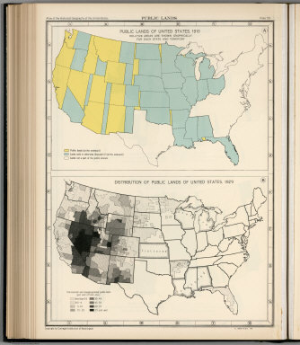
1932 Plate 57. Public Lands of United States, … [Historical Atlas, National Atlas] Plate 57. Public Lands. Public Lands of … |

1932 Plate 58. Public Lands of United States, … [Historical Atlas, National Atlas] Plate 58. Public Lands. Public Lands of … |
1932 Plate 59. Public Lands of United States, … [Historical Atlas, National Atlas] Plate 59. Public Lands. Public Lands of … |
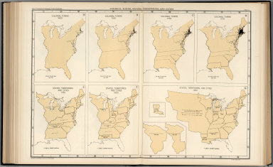
1932 Plate 61. Colonial Towns, States, Territ … [Historical Atlas, National Atlas] Plate 61. Colonial Towns, States, Territ … |

1932 Plate 62. States, Territories and Cities … [Historical Atlas, National Atlas] Plate 62. States, Territories and Cities … |

1932 Plate 63. States, Territories and Cities … [Historical Atlas, National Atlas] Plate 63. States, Territories and Cities … |

1932 Plate 64. States, Territories and Cities … [Historical Atlas, National Atlas] Plate 64. States, Territories and Cities … |

1932 Plate 65. States, Territories and Cities … [Historical Atlas, National Atlas] Plate 65. States, Territories and Cities … |

1932 Plate 66. States, Territories and Cities … [Historical Atlas, National Atlas] Plate 66. States, Territories and Cities … |

1932 Plate 67. States and Cities: Population, … [Historical Atlas, National Atlas] Plate 67. States and Cities: Population. … |

1866 Cover: Maps accompanying Report ... Gene … National Atlas (Covers to) Maps accompanying Report of … |

1866 Contents: Maps accompanying Report ... G … National Atlas (Contents to) Maps accompanying Report o … |

1866 United States, Territories. National Atlas Map of the United States and Territories … |