|
Full Title
Township 18 South, Range 28 East, Tulare Co., California. (Compiled, drawn and published by Thos. H. Thompson, Tulare, Cal. 1892)
Publisher
T.H. Thompson
Full Title
Township 19 South, Township 18 South, Range 29 East, Range 30 East, Tulare Co., California. (Compiled, drawn and published by Thos. H. Thompson, Tulare, Cal. 1892)
Publisher
T.H. Thompson
Full Title
Township 19 South, Township 18 South, Range 31 East, Range 32 East, Tulare Co., California. (Compiled, drawn and published by Thos. H. Thompson, Tulare, Cal. 1892)
Publisher
T.H. Thompson
Full Title
Township 20 South ... Township 18 South, Range 32 East ... Range 35 East, Tulare Co., California. (with) Map of Averill's Subdivision, Tulare County. (Compiled, drawn and published by Thos. H. Thompson, Tulare, Cal. 1892)
Publisher
T.H. Thompson
Full Title
Township 19 South, Range 20 East, Tulare Co., California. (Compiled, drawn and published by Thos. H. Thompson, Tulare, Cal. 1892)
Publisher
T.H. Thompson
Full Title
N.E. 1/4 T.19 S., R.20 E., Tulare Co., California. (Compiled, drawn and published by Thos. H. Thompson, Tulare, Cal. 1892)
Publisher
T.H. Thompson
Full Title
Township 19 South, Range 21 East, Tulare Co., California. (Compiled, drawn and published by Thos. H. Thompson, Tulare, Cal. 1892)
Publisher
T.H. Thompson
Full Title
Township 19 South, Range 22 East, Tulare Co., California. (Compiled, drawn and published by Thos. H. Thompson, Tulare, Cal. 1892)
Publisher
T.H. Thompson
Full Title
Township 19 South, Range 23 East, Tulare Co., California. (Compiled, drawn and published by Thos. H. Thompson, Tulare, Cal. 1892)
Publisher
T.H. Thompson
Full Title
Township 19 South, Range 24 East, Tulare Co., California. (Compiled, drawn and published by Thos. H. Thompson, Tulare, Cal. 1892)
Publisher
T.H. Thompson
Full Title
Township 19 South, Range 25 East, Tulare Co., California. (Compiled, drawn and published by Thos. H. Thompson, Tulare, Cal. 1892)
Publisher
T.H. Thompson
Full Title
Township 19 South, Range 26 East, Tulare Co., California. (Compiled, drawn and published by Thos. H. Thompson, Tulare, Cal. 1892)
Publisher
T.H. Thompson
Full Title
Township 19 South, Range 27 East, Tulare Co., California. (Compiled, drawn and published by Thos. H. Thompson, Tulare, Cal. 1892)
Publisher
T.H. Thompson
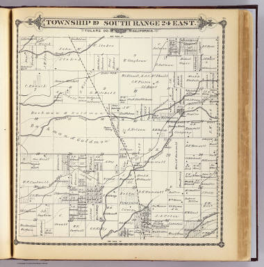
Full Title
Township 19 South, Range 28 East, Tulare Co., California. (Compiled, drawn and published by Thos. H. Thompson, Tulare, Cal. 1892)
Publisher
T.H. Thompson
Full Title
Township 20 South, Township 21 South, Range 18 East, Range 19 East, Tulare Co., California. (with) Township 21 South, Range 17 East. (Compiled, drawn and published by Thos. H. Thompson, Tulare, Cal. 1892)
Publisher
T.H. Thompson
Full Title
Township 20 South, Township 21 South, Range 20 East, Range 21 East, Tulare Co., California. (with) Map of Plano, Tulare Co. (Compiled, drawn and published by Thos. H. Thompson, Tulare, Cal. 1892)
Publisher
T.H. Thompson
Full Title
Township 20 South, Range 22 East, Tulare Co., California. (Compiled, drawn and published by Thos. H. Thompson, Tulare, Cal. 1892)
Publisher
T.H. Thompson
Full Title
Township 20 South, Range 23 East, Tulare Co., California. (Compiled, drawn and published by Thos. H. Thompson, Tulare, Cal. 1892)
Publisher
T.H. Thompson
Full Title
Township 20 South, Range 24 East, Tulare Co., California. (Compiled, drawn and published by Thos. H. Thompson, Tulare, Cal. 1892)
Publisher
T.H. Thompson
Full Title
Township 20 South, Range 25 East, Tulare Co., California. (Compiled, drawn and published by Thos. H. Thompson, Tulare, Cal. 1892)
Publisher
T.H. Thompson
Full Title
Township 20 South, Range 26 East, Tulare Co., California. (Compiled, drawn and published by Thos. H. Thompson, Tulare, Cal. 1892)
Publisher
T.H. Thompson
Full Title
Township 20 South, Range 27 East, Tulare Co., California. (Compiled, drawn and published by Thos. H. Thompson, Tulare, Cal. 1892)
Publisher
T.H. Thompson
Full Title
Township 20 South, Range 28 East, Tulare Co., California. (Compiled, drawn and published by Thos. H. Thompson, Tulare, Cal. 1892)
Publisher
T.H. Thompson
Full Title
Township 20 South, Range 29 East, Tulare Co., California. (Compiled, drawn and published by Thos. H. Thompson, Tulare, Cal. 1892)
Publisher
T.H. Thompson
Full Title
Township 21 South, Range 22 East, Tulare Co., California. (Compiled, drawn and published by Thos. H. Thompson, Tulare, Cal. 1892)
Publisher
T.H. Thompson
Full Title
Township 21 South, Range 23 East, Tulare Co., California. (Compiled, drawn and published by Thos. H. Thompson, Tulare, Cal. 1892)
Publisher
T.H. Thompson
Full Title
Township 21 South, Range 24 East, Tulare Co., California. (Compiled, drawn and published by Thos. H. Thompson, Tulare, Cal. 1892)
Publisher
T.H. Thompson
Full Title
Township 21 South, Range 25 East, Tulare Co., California. (Compiled, drawn and published by Thos. H. Thompson, Tulare, Cal. 1892)
Publisher
T.H. Thompson
Full Title
Township 21 South, Range 26 East, Tulare Co., California. (Compiled, drawn and published by Thos. H. Thompson, Tulare, Cal. 1892)
Publisher
T.H. Thompson
Full Title
Township 21 South, Range 27 East, Tulare Co., California. (Compiled, drawn and published by Thos. H. Thompson, Tulare, Cal. 1892)
Publisher
T.H. Thompson
Author
[United States. Army. Corps of Engineers, Wheeler, G.M.]
Full Title
Sketch indicating the advancement of the surveys of the public lands and the military topographical and geographical surveys west of the Mississippi. Prepared under the direction of 1st. Lieut. Geo. M. Wheeler, Corps of Engineers U.S. Army. 1879. (1889)
Publisher
U.S.
Author
[United States. Army. Corps of Engineers, Wheeler, G.M.]
Full Title
Sketch indicating a distribution of the territorial domain of the United States into districts favorable to the operations of parties prosecuting general government surveys. Prepared under the direction of 1st. Lieut. Geo. M. Wheeler, Corps of Engineers, U.S. Army. 1879. Originally devised January 1st 1875. U.S. Geographical Surveys West of the 100th Meridian. (1889)
Publisher
U.S.
Author
Lyon, Lucius, 1800-1851
Full Title
Town 8 South, Range 20 West, Town 8 South, Range 19 West (Berrien County, Michigan, 1829)
Publisher
Manuscript
Author
Lyon, Lucius, 1800-1851
Full Title
Town 7 South, Rang[e] 19 West. Surveyed in 1829 by L. Lyon, varr. 5035' E.
Publisher
Manuscript
Author
Lyon, Lucius, 1800-1851
Full Title
Town 8 South, Range 19 West. (Surveyed in 1829 by L. Lyon)
Publisher
Manuscript
Author
Lyon, Lucius, 1800-1851
Full Title
Town 7 South, Range 20 West. (Surveyed in 1829 by L. Lyon). Road dists. in Chikaming Tp. in 1861 (added in pencil)
Publisher
Manuscript
Author
Lyon, Lucius, 1800-1851
Full Title
Town 8 South, Range 20 West. (Surveyed in 1829 by L. Lyon).
Publisher
Manuscript
Author
Lyon, Lucius, 1800-1851
Full Title
T. 8 South, Range 21 West. (Surveyed in 1829 by L. Lyon).
Publisher
Manuscript
Author
Lyon, Lucius, 1800-1851
Full Title
T. 7 South, R. 21 West. T. 8 S., Range 22 W. (Surveyed in 1829 by L. Lyon).
Publisher
Manuscript
Author
Lyon, Lucius, 1800-1851
Full Title
(Case to) (Michigan and Indiana Border Survey 1828-1835. Manuscript survey maps and notes)
Publisher
Manuscript
Author
Lyon, Lucius, 1800-1851
Full Title
(Covers to) (Michigan and Indiana Border Survey 1828-1835. Manuscript survey maps and notes)
Publisher
Manuscript
Author
Lyon, Lucius, 1800-1851
Full Title
(Index to) (Michigan and Indiana Border Survey 1828-1835. Manuscript survey maps and notes)
Publisher
Manuscript
Author
Lyon, Lucius, 1800-1851
Full Title
(Text Page to) (Michigan and Indiana Border Survey 1828-1835. Manuscript survey maps and notes)
Publisher
Manuscript
Author
U.S. General Land Office
Full Title
Map of the United States and territories, with adjacent parts of Canada and Mexico also part of the West India islands, showing the extent of public surveys, Indian, military, and forest reservations, rail roads, canals, national parks and other details, compiled from official surveys of the General Land Office and other authentic sources. Under the direction of the Hon. Lewis A. Groff, Commissioner. A.F. Dinsmore, Chief, Draughting Division. 1890. Isaac Friedenwald, Photo. Litho. Balto. Md. (inset) Territory of Alaska.
Publisher
Isaac Friedenwald Photo Litho.
Author
[Paullin, Charles O., Wright, John K.]
Full Title
Plate 57. Public Lands. Public Lands of United States, 1790. Public Lands of United States, 1810.
Publisher
[Carnegie Institution of Washington, American Geographical Society of New York]
Author
[Paullin, Charles O., Wright, John K.]
Full Title
Plate 58. Public Lands. Public Lands of United States, 1830. Public Lands of United States, 1850. Public Lands of United States, 1870. Public Lands of United States, 1890.
Publisher
[Carnegie Institution of Washington, American Geographical Society of New York]
Author
[Paullin, Charles O., Wright, John K.]
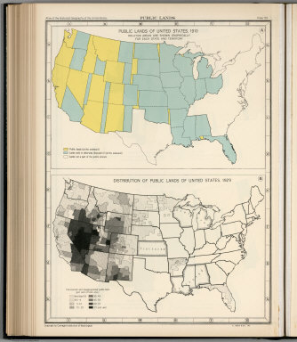
Full Title
Plate 59. Public Lands. Public Lands of United States, 1910. Distribution of Public Lands of United States, 1929.
Publisher
[Carnegie Institution of Washington, American Geographical Society of New York]
Author
[Paullin, Charles O., Wright, John K.]
Full Title
Plate 61. Colonial Towns, States, Territories, and Cities. Colonial Towns, 1650. Colonial Towns, 1700. Colonial Towns, 1750. Colonial Towns, 1775. States, Territories and Cities, 1790. States, Territories and Cities, 1800. States, Territories and Cities, 1810.
Publisher
[Carnegie Institution of Washington, American Geographical Society of New York]
Author
[Paullin, Charles O., Wright, John K.]
Full Title
Plate 62. States, Territories and Cities. States, Territories and Cities, 1820. States, Territories and Cities, 1830.
Publisher
[Carnegie Institution of Washington, American Geographical Society of New York]
Author
[Paullin, Charles O., Wright, John K.]
Full Title
Plate 63. States, Territories and Cities. States, Territories and Cities, 1840. States, Territories and Cities, 1850.
Publisher
[Carnegie Institution of Washington, American Geographical Society of New York]
|