Who What Where WhenREMOVE |
Author
[Stieler, Adolf, Vogel, C.]
Full Title
Stieler's Hand-Atlas No. 18. Das Deutsche Reich und Seine Nachbarlander zur Ubersichtn der Eisenbahnen und Dampfschiffahrten.
Publisher
Justus Perthus
Author
Stieler, Adolf
Full Title
No. XXVI. Stieler's Hand-Atlas (No. 20.) Deutschland und anliegende Lander, zur Ubersicht der Eisenbahnen und Hauptstrassen.
Publisher
Justus Perthes
Author
Stieler, Adolf
Full Title
Deutschland Und Benachbarte Lander. Zur Ubersicht Der Eisenbahnen Und Dampfschiffahrten. Bearbeitet von C. Vogel. Abgeschlossen im August 1871. Gestochen von H. Eberhardt. Gotha: Justus Perthes. 1872.
Publisher
Justus Perthes
Author
Cram, George Franklin
Full Title
Railroad and County Map of New Jersey.
Publisher
A.C. Shewey and Co.
Author
Cram, George Franklin
Full Title
New Rail Road and County Map of Deleware (Delaware), Maryland, Virginia & West Virginia.
Publisher
A.C. Shewey and Co.
Author
Cram, George Franklin
Full Title
New Rail Road and Count Map of North Carolina.
Publisher
A.C. Shewey and Co.
Author
Cram, George Franklin
Full Title
New Rail Road and County Map of Alabama, Georgia, Sth. Carolina & Northern Florida.
Publisher
A.C. Shewey and Co.
Author
Cram, George Franklin
Full Title
New Rail Road and County Map of Kentucky & Tennessee.
Publisher
A.C. Shewey and Co.
Author
Cram, George Franklin
Full Title
New Rail Road and County Map of Missouri.
Publisher
A.C. Shewey and Co.
Author
Cram, George Franklin
Full Title
New Rail Road and County Map of Michigan & Wisconsin.
Publisher
A.C. Shewey and Co.
Author
Bradford, Thomas G.
Full Title
United States, exhibiting the railroads & canals. (to accompany) A Comprehensive Atlas, Geographical, Historical & Commercial. By T.G. Bradford. William D. Ticknor, Boston. Wiley & Long, New-York. Entered ... 1835, by Thos. G. Bradford ... Massachusetts.
Publisher
[William D. Ticknor, Wiley & Long]
Author
[Gray, Frank A., Gray, O.W.]
Full Title
Gray's Atlas New Rail Road and County Map of the States of Oregon, California, and Nevada Compiled and Drawn by Frank A. Gray. Published by O.W. Gray, Phladelphia. (inset) Enlarged Plan of the Vicinity of San Francisco and Sacramento.
Publisher
Stedman, Brown & Lyon
Author
Andriveau-Goujon, J.
Full Title
Carte particuliere de l'Angleterre et de la Principaute de Galles. Indiquant les principales routes, les chemins de fer, les canaux de navigation &a. Publiee par J. Andriveau-Goujon, Rue du Bac, no. 21, Paris, 1849. Imp. Lemercier, a Paris.
Publisher
J. Andriveau-Goujon
Author
Society for the Diffusion of Useful Knowledge (Great Britain)
Full Title
England with its canals and railways. Published under the superintendence of the Society for the Diffusion of Useful Knowledge. London, published by Baldwin & Cradock, 47 Paternoster Row Octr. 1st. 1837. Engd. by J. & C. Walker. (London: Chapman and Hall, 1844)
Publisher
Chapman and Hall
Author
Rand McNally and Company
Full Title
Rand, McNally & Co.'s indexed atlas of the world map of Colombia and Venezuela. (with) Isthmus of Panama showing location of railroad and canal. (with) Map showing railroad between Caracas and La Guayra. Copyright 1892, by Rand, McNally & Co. ... Engravers, Chicago, (1897)
Publisher
Rand McNally
Author
Hammond, C.S.
Full Title
Europe. 7426. Central Europe at Outbreak of World War II - Sept. 1939. 1389. 1939 Language Map of Europe.
Publisher
Garden City Publishing Company, Inc.
Author
Gray, Ormando Willis
Full Title
Gray's Atlas New Railroad and County Map of the States of Oregon, California, and Nevada Compiled and Drawn by Frank A. Gray. Published by O.W. Gray, Philadelphia. (inset) Enlarged Plan of the Vicinity of San Francisco and Sacramento.
Publisher
Stedman, Brown & Lyon
Author
Mitchell, Samuel Augustus Jr.
Full Title
Railroad map of the United States, showing the through lines of communication from the Atlantic to the Pacific, together with the various steamship lines along the seaboard. Copyright by Wm. M. Bradley & Bro. 1884.
Publisher
Wm. M. Bradley & Bro.
Author
Mitchell, Samuel Augustus Jr.
Full Title
Map of Mexico, Central America, and the West Indies. (with) Map of the Bermuda Islands. (with) Map of the island of Jamaica. (with) Map of the proposed ship rail road route across the isthmus of Tehuantepec. (with) Map of the Panama Railroad and proposed canal. (with) Map of the proposed Nicaragua Canal route. Copyright by S. Augustus Mitchell 1884.
Publisher
Wm. M. Bradley & Bro.
Full Title
Railroad map of the United States, showing the through lines of communication from the Atlantic to the Pacific, together with the various steamship lines along the seaboard. W. H. Gamble, Sc. Copyright 1886 by Wm. M. Bradley & Bro.
Publisher
Wm. M. Bradley & Bro.
Full Title
Map of Mexico, Central America, and the West Indies. (with) Map of the Bermuda Islands. (with) Map of the island of Jamaica. (with) Map of the proposed ship rail road route across the isthmus of Tehuantepec. (with) Map of the Panama Railroad and proposed canal. (with) Map of the proposed Nicaragua Canal route. Copyright 1886 by Wm. M. Bradley & Bro.
Publisher
Wm. M. Bradley & Bro.
Author
Rand McNally and Company
Full Title
Rand, McNally & Co.'s indexed atlas of the world street guide map of Chicago. Rand, McNally & Co's map of Chicago and suburbs. Copyright, 1890 by Rand, McNally & Co. (Chicago, 1897)
Publisher
Rand McNally
Author
Rand McNally and Company
Full Title
Rand, McNally & Co.'s indexed atlas of the world railway terminal map of Chicago. Rand, McNally & Co's new business atlas map of Chicago. Copyright, 1892, by Rand, McNally & Co., Chicago. (1897)
Publisher
Rand McNally
Author
Gray, Ormando Willis
Full Title
Map of Richmond, Henrico County, Virginia. (inset continuation of main map).
Publisher
O.W. Gray & Son
Author
Gray, Ormando Willis
Full Title
Edinburg, Shenandoah County, Virginia.
Publisher
O.W. Gray & Son
Author
Gray, Ormando Willis
Full Title
Woodstock, Shenandoah County, Virginia.
Publisher
O.W. Gray & Son
Author
Gray, Ormando Willis
Full Title
Mt. Jackson, Shenandoah County, Virginia. New Market, Shenandoah County, Virginia.
Publisher
O.W. Gray & Son
Author
Gray, Ormando Willis
Full Title
Gray's New Map of Lexington, Rockingham County, Virginia. Drawn from Special Surveys, 1877. Drawn, Engraved, and Published by O.W. Gray & Son, Geographers, Manufacturers of Maps and Atlases, 10 North Fifth Street, Philadelphia. Jacob Chace, Topographical Engineer, Manager of Local Surveys.
Publisher
O.W. Gray & Son
Author
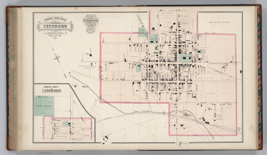
Gray, Ormando Willis
Full Title
Gray's New Map of Leesburg, Loudoun Co., Virginia. Drawn from Special Surveys, 1878. Drawn, Engraved, and Published by O.W. Gray & Son, Geographers, Manufacturers of Maps and Atlases, 10 North Fifth Street, Philadelphia. Jacob Chace, Topographical Engineer, Manager of Local Surveys. George Chace, Assistant Engineer. (inset a continuation of main map).
Publisher
O.W. Gray & Son
Author
Gray, Ormando Willis
Full Title
Strasburg, Shenandoah County, Virginia.
Publisher
O.W. Gray & Son
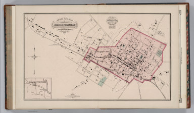
Author
Gray, Ormando Willis
Full Title
Gray's New Map of Charlottesville, Albemarle County, Virginia. Drawn from Special Surveys, 1877. Drawn, Engraved, and Published by O.W. Gray & Son, Geographers, Manufacturers of Maps and Atlases, 10 North Fifth Street, Philadelphia. Jacob Chace, Topographical Engineer, Manager of Local Surveys. (inset) (Vicinity of) Charlottesville.
Publisher
O.W. Gray & Son
Author
Gray, Ormando Willis
Full Title
Map of Orange Court House, Orange County, Virginia. Philadelphia: O.W. Gray & Son.
Publisher
O.W. Gray & Son
Author
Gray, Ormando Willis
Full Title
Gray's New Map of Culpepper, Culpepper County, Virginia. Drawn from Special Surveys, 1878. Drawn, Engraved, and Published by O.W. Gray & Son, Geographers, Manufacturers of Maps and Atlases, 10 North Fifth Street, Philadelphia. Jacob Chace, Topographical Engineer, Manager of Local Surveys. George Chace, Assistant Engineer.
Publisher
O.W. Gray & Son
Author
Gray, Ormando Willis
Full Title
Gray's New Map of Gordonsville, Orange County, Virginia. Drawn from Special Surveys, 1878. Philadelphia: O.W. Gray & Son. Gray's New Map of Harrisonburg (Outline), Rockingham County, Virginia. Drawn from Special Surveys, 1877. Philadelphia: O.W. Gray & Son.
Publisher
O.W. Gray & Son
Author
Gray, Ormando Willis
Full Title
Gray's New Map of Harrisonburg, Rockingham Co., Virginia. Drawn from Special Surveys, 1877. Drawn, Engraved, and Published by O.W. Gray & Son, Geographers, Manufacturers of Maps and Atlases, 10 North Fifth Street, Philadelphia. Jacob Chace, Topographical Engineer, Manager of Local Surveys.
Publisher
O.W. Gray & Son
|