Who What Where WhenREMOVE |
Author
Andriveau-Goujon, J.
Full Title
Mappemonde en deux hemispheres. Publiee par J. Andriveau-Goujon, Geographe-Editeur, Rue du Bac, no. 17, Paris, 1849.
Publisher
J. Andriveau-Goujon
Author
Dussieux, L.
Full Title
113. Mappe Monde Indiquant les Colonies Espagnoles et Portugaises au XVIe siecle et les grandes decouvertes geographiques.
Publisher
Jacques Lecoffre et Comp.
Author
Mitchell, Samuel Augustus
Full Title
(Covers to) A New Universal Atlas Containing Maps of the various Empires, Kingdoms, States and Republics Of The World. With a special map of each of the United States, Plans of Cities &c. Comprehended in seventy sheets and forming a series of One Hundred And Seventeen Maps, Plans And Sections ... Philadelphia, Published By S. Augustus Mitchell, N.E. corner of Market & 7th Streets. 1846. Entered ... 1846, by H.N. Burroughs ... Pennsylvania. (title page by) J. Knight Sc.
Publisher
S.A. Mitchell
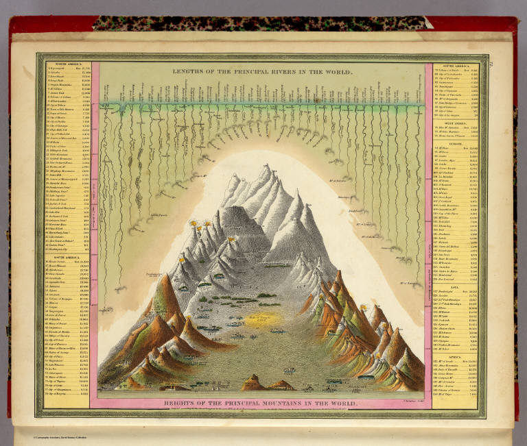
Author
Mitchell, Samuel Augustus
Full Title
Heights Of The Principal Mountains In The World. Lengths Of The Principal Rivers In The World. F. Humphrys. Sculpt. Entered ... 1846, H.N. Burroughs ... Pennsylvania.
Publisher
S.A. Mitchell
Author
Mitchell, Samuel Augustus
Full Title
(Title Page to) A New Universal Atlas Containing Maps of the various Empires, Kingdoms, States and Republics Of The World. With a special map of each of the United States, Plans of Cities &c. Comprehended in seventy sheets and forming a series of One Hundred And Seventeen Maps, Plans And Sections ... Philadelphia, Published By S. Augustus Mitchell, N.E. corner of Market & 7th Streets. 1846. Entered ... 1846, by H.N. Burroughs ... Pennsylvania. (title page by) J. Knight Sc.
Publisher
S.A. Mitchell
Author
Mitchell, Samuel Augustus
Full Title
(Contents to) A New Universal Atlas Containing Maps of the various Empires, Kingdoms, States and Republics Of The World. With a special map of each of the United States, Plans of Cities &c. Comprehended in seventy sheets and forming a series of One Hundred And Seventeen Maps, Plans And Sections ... Philadelphia, Published By S. Augustus Mitchell, N.E. corner of Market & 7th Streets. 1846. Entered ... 1846, by H.N. Burroughs ... Pennsylvania. (title page by) J. Knight Sc.
Publisher
S.A. Mitchell
Author
Mitchell, Samuel Augustus
Full Title
A New Map Of The World on the Globular Projection. Philadelphia. Published By S. Augustus Mitchell, N.E. corner of Market & 7th Streets. 1846.
Publisher
S.A. Mitchell
Author
Lucas, Fielding Jr.
Full Title
(Covers to) A General Atlas Containing Distinct Maps Of all the Known Countries in the World, Constructed from the Latest Authority. Written and Engraved by Jos. Perkins, Philadelphia. Baltimore: Published by Fielding Lucas, Jun. No. 138, Market Street. Baltimore. Entered ... by F. Lucas Jr. of the State of Maryland June 3, 1823.
Publisher
Fielding Lucas Jr.
Author
Tanner, Henry S.
Full Title
(Covers to) A New American Atlas Containing Maps Of The Several States of the North American Union, Projected and drawn on a Uniform Scale from Documents found in the public Offices of the United States and State Governments, and other Original and Authentic Information, By Henry S. Tanner ... Philadelphia: Published By H.S. Tanner. 1823. (title page only) Writing Drawn and Engraved by Joseph Perkins. Barralet del. Humphrys sc.
Publisher
Henry Tanner
Author
Tanner, Henry S.
Full Title
(Half Title Page to) A New American Atlas Containing Maps Of The Several States of the North American Union, Projected and drawn on a Uniform Scale from Documents found in the public Offices of the United States and State Governments, and other Original and Authentic Information, By Henry S. Tanner ... Philadelphia: Published By H.S. Tanner. 1823. (title page only) Writing Drawn and Engraved by Joseph Perkins. Barralet del. Humphrys sc.
Publisher
Henry Tanner
Author
Tanner, Henry S.
Full Title
(Title Page to) A New American Atlas Containing Maps Of The Several States of the North American Union, Projected and drawn on a Uniform Scale from Documents found in the public Offices of the United States and State Governments, and other Original and Authentic Information, By Henry S. Tanner ... Philadelphia: Published By H.S. Tanner. 1823. (title page only) Writing Drawn and Engraved by Joseph Perkins. Barralet del. Humphrys sc.
Publisher
Henry Tanner
Author
Tanner, Henry S.
Full Title
(Index Page to) A New American Atlas Containing Maps Of The Several States of the North American Union, Projected and drawn on a Uniform Scale from Documents found in the public Offices of the United States and State Governments, and other Original and Authentic Information, By Henry S. Tanner ... Philadelphia: Published By H.S. Tanner. 1823. (title page only) Writing Drawn and Engraved by Joseph Perkins. Barralet del. Humphrys sc.
Publisher
Henry Tanner
Author
Tanner, Henry S.
Full Title
(Geographical Memoir, pg. 1 in) A New American Atlas Containing Maps Of The Several States of the North American Union, Projected and drawn on a Uniform Scale from Documents found in the public Offices of the United States and State Governments, and other Original and Authentic Information, By Henry S. Tanner ... Philadelphia: Published By H.S. Tanner. 1823. (title page only) Writing Drawn and Engraved by Joseph Perkins. Barralet del. Humphrys sc.
Publisher
Henry Tanner
Author
Tanner, Henry S.
Full Title
(Geographical Memoir, pgs. 2-3 in) A New American Atlas Containing Maps Of The Several States of the North American Union, Projected and drawn on a Uniform Scale from Documents found in the public Offices of the United States and State Governments, and other Original and Authentic Information, By Henry S. Tanner ... Philadelphia: Published By H.S. Tanner. 1823. (title page only) Writing Drawn and Engraved by Joseph Perkins. Barralet del. Humphrys sc.
Publisher
Henry Tanner
Author
Tanner, Henry S.
Full Title
(Geographical Memoir, pgs. 4-5 in) A New American Atlas Containing Maps Of The Several States of the North American Union, Projected and drawn on a Uniform Scale from Documents found in the public Offices of the United States and State Governments, and other Original and Authentic Information, By Henry S. Tanner ... Philadelphia: Published By H.S. Tanner. 1823. (title page only) Writing Drawn and Engraved by Joseph Perkins. Barralet del. Humphrys sc.
Publisher
Henry Tanner
Author
Tanner, Henry S.
Full Title
(Geographical Memoir, pgs. 6-7 in) A New American Atlas Containing Maps Of The Several States of the North American Union, Projected and drawn on a Uniform Scale from Documents found in the public Offices of the United States and State Governments, and other Original and Authentic Information, By Henry S. Tanner ... Philadelphia: Published By H.S. Tanner. 1823. (title page only) Writing Drawn and Engraved by Joseph Perkins. Barralet del. Humphrys sc.
Publisher
Henry Tanner
Author
Tanner, Henry S.
Full Title
(Geographical Memoir, pgs. 8-9 in) A New American Atlas Containing Maps Of The Several States of the North American Union, Projected and drawn on a Uniform Scale from Documents found in the public Offices of the United States and State Governments, and other Original and Authentic Information, By Henry S. Tanner ... Philadelphia: Published By H.S. Tanner. 1823. (title page only) Writing Drawn and Engraved by Joseph Perkins. Barralet del. Humphrys sc.
Publisher
Henry Tanner
Author
Tanner, Henry S.
Full Title
(Geographical Memoir, pgs. 10-11 in) A New American Atlas Containing Maps Of The Several States of the North American Union, Projected and drawn on a Uniform Scale from Documents found in the public Offices of the United States and State Governments, and other Original and Authentic Information, By Henry S. Tanner ... Philadelphia: Published By H.S. Tanner. 1823. (title page only) Writing Drawn and Engraved by Joseph Perkins. Barralet del. Humphrys sc.
Publisher
Henry Tanner
Author
Tanner, Henry S.
Full Title
(Geographical Memoir, pgs. 12-13 in) A New American Atlas Containing Maps Of The Several States of the North American Union, Projected and drawn on a Uniform Scale from Documents found in the public Offices of the United States and State Governments, and other Original and Authentic Information, By Henry S. Tanner ... Philadelphia: Published By H.S. Tanner. 1823. (title page only) Writing Drawn and Engraved by Joseph Perkins. Barralet del. Humphrys sc.
Publisher
Henry Tanner
Author
Tanner, Henry S.
Full Title
(Geographical Memoir, pgs. 14-15 in) A New American Atlas Containing Maps Of The Several States of the North American Union, Projected and drawn on a Uniform Scale from Documents found in the public Offices of the United States and State Governments, and other Original and Authentic Information, By Henry S. Tanner ... Philadelphia: Published By H.S. Tanner. 1823. (title page only) Writing Drawn and Engraved by Joseph Perkins. Barralet del. Humphrys sc.
Publisher
Henry Tanner
Author
Tanner, Henry S.
Full Title
(Geographical Memoir, pgs. 16-17 in) A New American Atlas Containing Maps Of The Several States of the North American Union, Projected and drawn on a Uniform Scale from Documents found in the public Offices of the United States and State Governments, and other Original and Authentic Information, By Henry S. Tanner ... Philadelphia: Published By H.S. Tanner. 1823. (title page only) Writing Drawn and Engraved by Joseph Perkins. Barralet del. Humphrys sc.
Publisher
Henry Tanner
Author
Tanner, Henry S.
Full Title
(Geographical Memoir, pg. 18 in) A New American Atlas Containing Maps Of The Several States of the North American Union, Projected and drawn on a Uniform Scale from Documents found in the public Offices of the United States and State Governments, and other Original and Authentic Information, By Henry S. Tanner ... Philadelphia: Published By H.S. Tanner. 1823. (title page only) Writing Drawn and Engraved by Joseph Perkins. Barralet del. Humphrys sc.
Publisher
Henry Tanner
Author
Tanner, Henry S.
Full Title
(Text page in) A New American Atlas Containing Maps Of The Several States of the North American Union, Projected and drawn on a Uniform Scale from Documents found in the public Offices of the United States and State Governments, and other Original and Authentic Information, By Henry S. Tanner ... Philadelphia: Published By H.S. Tanner. 1823. (title page only) Writing Drawn and Engraved by Joseph Perkins. Barralet del. Humphrys sc.
Publisher
Henry Tanner
Author
Tanner, Henry S.
Full Title
The World on Mercators Projection. Engraved & Published by Tanner, Vallance, Kearney & Co. Philadelphia. American Atlas.
Publisher
Henry Tanner
Author
Berghaus, Heinrich
Full Title
(Covers to Vol. 1) Dr. Heinrich Berghaus' Physikalischer Atlas oder Sammlung von Karten, auf denen die hauptsachlichsten Erscheinungen der anorganischen und organischen Natur nach ihrer geographischen Verbreitung und Vertheilung bildlich dargestellt sind ... 1845. Verlag von Justus Perthes in Gotha ... 1848 ...
Publisher
Justus Perthes
Author
Berghaus, Heinrich
Full Title
(Title Page to Vol. 1) Dr. Heinrich Berghaus' Physikalischer Atlas oder Sammlung von Karten, auf denen die hauptsachlichsten Erscheinungen der anorganischen und organischen Natur nach ihrer geographischen Verbreitung und Vertheilung bildlich dargestellt sind ... 1845. Verlag von Justus Perthes in Gotha ... 1848 ...
Publisher
Justus Perthes
Author
Berghaus, Heinrich
Full Title
(Index Page to Vol. 1) Dr. Heinrich Berghaus' Physikalischer Atlas oder Sammlung von Karten, auf denen die hauptsachlichsten Erscheinungen der anorganischen und organischen Natur nach ihrer geographischen Verbreitung und Vertheilung bildlich dargestellt sind ... 1845. Verlag von Justus Perthes in Gotha ... 1848 ...
Publisher
Justus Perthes
Author
[Berghaus, Heinrich, Humboldt, Alexander von, 1769-1859]
Full Title
Alexander von Humboldt's System Der Isotherm-Kurven, in Merkator's Projection. 1ste. Abtheilung: Meteorologie No. 1. Gezeichnet v. Bar u. F. Schelle, nach Berghaus' Entwurf. Gestochen bei Madel II. Gotha, J. Perthes. 1838. Zweite Auflage. 1849.
Publisher
Justus Perthes
Author
Berghaus, Heinrich
Full Title
Die Isothermkurven Der Nordlichen Halbkugel. 1ste. Abtheilung: Meteorologie No. 2. Gezeichnet v. Bar, Berghaus, u. Schelle. In Potsdam Gestochen von K. Kolbe. Gotha, J. Perthes. 1838.
Publisher
Justus Perthes
Author
Berghaus, Heinrich
Full Title
Die Hauptmomente Der Temperatur Auf Dem Ganzen Erboden, gegrundet auf die Beobachtungen an 307 Orten. Thermometer-Centigrade. 1ste Abtheilung: Meteorologie No. 4.
Publisher
Justus Perthes
Author
Berghaus, Heinrich
Full Title
Graphische Darstellung des Ganges der Temperatur Innerhalb Der Tagl. Und Jahrl. Periode in Allen Zonen. 1ste. Abtheilung: Meteorologie No. 5. Potsdam, in der Geographischen Kunstschule. Gotha, bei Justus Perthes. 1839. Zweite Auflage. 1849.
Publisher
Justus Perthes
Author
Berghaus, Heinrich
Full Title
Ubersicht Der Mittleren Barometerstande Am Meere Und Der Oscillationen Des Luftdrucks. 1ste. Abtheilung: Meteorologie No. 6. Gest. v. W. Barns. Gotha, Justus Perthes. 1839.
Publisher
Justus Perthes
Author
Berghaus, Heinrich
Full Title
Windkarte der Erde. 1ste. Abtheilung: Meteorologie No. 7. Gezeichnet in der geographischen Kunstschule zu Potsdam. Gestochen von Edler. Gotha, Justus Perthes. 1840.
Publisher
Justus Perthes
Author
Berghaus, Heinrich
Full Title
Hyetographische Karte der Erde. 1ste. Abtheilung Meteorologie No. 9. Gez. u. gest. in der geogr. Kunstschule zu Potsdam. Gotha, bei J. Perthes. 1841.
Publisher
Justus Perthes
Author
Mitchell, Samuel Augustus
Full Title
(Index Page to) Mitchell's New General Atlas, Containing Maps Of The Various Countries Of The World, Plans Of Cities, Etc. Embraced In Forty-Seven Quarto Maps, Forming A Series Of Seventy-Six Maps And Plans, Together With Valuable Statistical Tables. Philadelphia: Published By S. Augustus Mitchell, Jr. No. 31 South Sixth Street. 1860. Entered ... 1860, by S. Augustus Mitchell, Jr. ... Pennsylvania.
Publisher
S.A. Mitchell, Jr.
Author
[La Martiniere, La Perouse, Jean-Francois de Galaup, comte de, 1741-1788]
Full Title
Insectes. Dessine par La Martiniere. Grave par PP. Choffard. L. Aubert scripsit. Atlas du Voyage de la Perouse, no. 20. (Paris: L'Imprimerie de la Republique, An V, 1797)
Publisher
L'Imprimerie de la Republique
Author
Mitchell, Samuel Augustus
Full Title
Map Of The World On The Globular Projection Exhibiting the Eastern And Western Hemispheres. Constructed and Engd. by W. Williams Phila. No. 1. Entered ... 1860, by S. Augustus Mitchell, Jr. ... Pennsylvania.
Publisher
S.A. Mitchell, Jr.
Author
Mitchell, Samuel Augustus
Full Title
Map Of The World On The Mercator Projection Exhibiting the American Continent As It's Centre. 2. Entered ... 1860, by S. Augustus Mitchell, Jr. ... Pennsylvania.
Publisher
S.A. Mitchell, Jr.
Author
[Bonne, Rigobert, 1727-1794, Lattre, Jean]
Full Title
(Covers to) Atlas moderne ou collection de cartes sur toutes les parties du globe terrestre ar plusieurs auteurs. Avec approbation & privilege du Roy. A Paris, Chez Lattre Graveur Ordinaire du Roy, de Mgr. Le Duc d'Orleans et de la Ville Rue St. Jacques No. 20. et Delalain Libraire, rue de la Comedie Francoise, (1791) (title page only) Monnet del. 1762. Prevost Sculp.
Publisher
Lattre & Delalain
Author
[Bonne, Rigobert, 1727-1794, Lattre, Jean]
Full Title
(Title Page to) Atlas moderne ou collection de cartes sur toutes les parties du globe terrestre ar plusieurs auteurs. Avec approbation & privilege du Roy. A Paris, Chez Lattre Graveur Ordinaire du Roy, de Mgr. Le Duc d'Orleans et de la Ville Rue St. Jacques No. 20. et Delalain Libraire, rue de la Comedie Francoise, (1791) (title page only) Monnet del. 1762. Prevost Sculp.
Publisher
Lattre & Delalain
Author
[Bonne, Rigobert, 1727-1794, Lattre, Jean]
Full Title
(Text Page to) Atlas moderne ou collection de cartes sur toutes les parties du globe terrestre ar plusieurs auteurs. Avec approbation & privilege du Roy. A Paris, Chez Lattre Graveur Ordinaire du Roy, de Mgr. Le Duc d'Orleans et de la Ville Rue St. Jacques No. 20. et Delalain Libraire, rue de la Comedie Francoise, (1791)
Publisher
Lattre & Delalain
Author
[Bonne, Rigobert, 1727-1794, Lattre, Jean]
Full Title
(Contents to) Atlas moderne ou collection de cartes sur toutes les parties du globe terrestre ar plusieurs auteurs. Avec approbation & privilege du Roy. A Paris, Chez Lattre Graveur Ordinaire du Roy, de Mgr. Le Duc d'Orleans et de la Ville Rue St. Jacques No. 20. et Delalain Libraire, rue de la Comedie Francoise, (1791)
Publisher
Lattre & Delalain
Author
[Bonne, Rigobert, 1727-1794, Lattre, Jean]
Full Title
Sphere de Copernic. Sphere de Ptolemee. Globe Terrestre. Globe Celeste. (A Paris, Chez Lattre Graveur, et Delalain Libraire, 1791)
Publisher
Lattre & Delalain
Author
[Goujon, J, Andriveau, J.]
Full Title
Tableau Comparatif et Figure de La Hauteur des Principales Montagnes et du Cours des Principaux Fleuves due Monde. Les Fleuves graves par Dumortier. Les Montagnes par A. Hocquart. La Lettre par Arnoul. Paris. Chez J. Goujon & J. Andriveau. Geographes - Editeurs. Rue du Bac, No. 6, Pres le Pont Royal. 1836.
Publisher
Goujon, J.; Andriveau, J.
Author
Polish Army Topography Service
Full Title
(Covers) Pergamon World Atlas. Pergamon Press. Oxford, London, New York, Toronto, Sydney, Paris, Braunschweig, Tokyo. P.W.N. - Poland. Polish Scientific Publishers. Warszawa. 1968.
Publisher
Pergamon Press
Author
Polish Army Topography Service
Full Title
(Frontispiece) Pergamon World Atlas. Pergamon Press. Oxford, London, New York, Toronto, Sydney, Paris, Braunschweig, Tokyo. P.W.N. - Poland. Polish Scientific Publishers. Warszawa. 1968.
Publisher
Pergamon Press
Author
Polish Army Topography Service
Full Title
(Text Page) Erratum. (for Pergamon World Atlas. Pergamon Press. Oxford, London, New York, Toronto, Sydney, Paris, Braunschweig, Tokyo. P.W.N. - Poland. Polish Scientific Publishers. Warszawa. 1968.).
Publisher
Pergamon Press
Author
Polish Army Topography Service
Full Title
(Title Page) Pergamon World Atlas. Pergamon Press. Oxford, London, New York, Toronto, Sydney, Paris, Braunschweig, Tokyo. P.W.N. - Poland. Polish Scientific Publishers. Warszawa. 1968.
Publisher
Pergamon Press
|