|
|
Author
Carey, Mathew
Full Title
Missouri Territory formerly Louisiana. Bower, Sc.
Publisher
Mathew Carey
Author
Carey, Mathew
Full Title
Plat of The Seven Ranges Of Townships being Part of the Territory of the United States N.W. of the River Ohio Which by a late act of Congress are directed to be sold. Surveyed in conformity to an Ordinance of Congress of May 20th 1785. Under direction of Thos. Hutchins late Geographer to the United States.
Publisher
Mathew Carey
Author
Carey, Mathew
Full Title
Mexico or New Spain. (with) inset map of southern Mexico and Central America.
Publisher
Mathew Carey
Author
Carey, Mathew
Full Title
A Chart of the West Indies, From the latest Marine Journals and Surveys.
Publisher
Mathew Carey
Author
Carey, Mathew
Full Title
Carte De La Partie Francoise De St. Domingue Faite par Bellin Ingr. de la Marine et depuis augmentee par P.C. Varle et autres Ingis. A Map Of The French Part Of St. Domingo. J.T. Scott Sculp. Philada.
Publisher
Mathew Carey
Author
Carey, Mathew
Full Title
A New Map of South America From the Latest Authorities.
Publisher
Mathew Carey
Author
Carey, Mathew
Full Title
A New Map of the Caracas. Warnicke Sc.
Publisher
Mathew Carey
Author
Carey, Mathew
Full Title
Peru. (with) inset map of eastern Peru.
Publisher
Mathew Carey
Author
Carey, Mathew
Full Title
Chili And Part Of The Viceroyalty Of La Plata. Lewis delin. W. Robinson Sc.
Publisher
Mathew Carey
Author
Carey, Mathew
Full Title
A Map of Brazil, now called New Portugal.
Publisher
Mathew Carey
Author
Carey, Mathew
Full Title
Europe. Bower.
Publisher
Mathew Carey
Author
Carey, Mathew
Full Title
Sweden, Denmark, Norway and Finland. from the best Authorities. Engraved by S. Hill Boston. (with) inset map of Iceland.
Publisher
Mathew Carey
Author
Carey, Mathew
Full Title
The Russian Empire, in Europe and Asia.
Publisher
Mathew Carey
Author
Carey, Mathew
Full Title
Scotland with the Principal Roads from the best Authorities. (with) inset map of the Shetland Isles.
Publisher
Mathew Carey
Author
Carey, Mathew
Full Title
An Accurate Map of England and Wales With The Principal Roads from the best Authorities.
Publisher
Mathew Carey
Author
Carey, Mathew
Full Title
A Map of Ireland According to the best Authorities.
Publisher
Mathew Carey
Author
Carey, Mathew
Full Title
Holland Or The Seven United Provinces, And The Netherlands. S. Lewis, delin.
Publisher
Mathew Carey
Author
Carey, Mathew
Full Title
France Divided into Circles and Departments.
Publisher
Mathew Carey
Author
Carey, Mathew
Full Title
Turkey, in Europe and Hungary; from the best Authorities.
Publisher
Mathew Carey
Author
Carey, Mathew
Full Title
Spain And Portugal. S. Lewis del. J.G. Warnicke Sculp.
Publisher
Mathew Carey
Author
Carey, Mathew
Full Title
Italy, and Sardinia, from the best Authorities. Bower.
Publisher
Mathew Carey
Author
Carey, Mathew
Full Title
Switzerland According to the best Authorities.
Publisher
Mathew Carey
Author
Carey, Mathew
Full Title
Asia According to the best Authorities.
Publisher
Mathew Carey
Author
Carey, Mathew
Full Title
China, divided into it's Great Provinces According to the best Authorities. B. Tanner Sc. N. York.
Publisher
Mathew Carey
Author
Carey, Mathew
Full Title
An Accurate Map of Hindostan or India, from the best Authorities.
Publisher
Mathew Carey
Author
Carey, Mathew
Full Title
The Islands of the East Indies with the Channels between India, China & New Holland comprising Philippine Isles ... Moluccas ... Isles of Sunda. Scoles sculp.
Publisher
Mathew Carey
Author
Carey, Mathew
Full Title
A New and Accurate Map of New South Wales, with Norfolk and Lord Howe's Islands Port Jackson &c. from Actual Surveys. Gridley Sc. (with) three inset maps of Port Jackson, Botany Bay &c.; Ld. Howe's Island; Norfolk Island.
Publisher
Mathew Carey
Author
Carey, Mathew
Full Title
Africa According to the best Authorities.
Publisher
Mathew Carey
Author
Carey, Mathew
Full Title
A map of the countries situate about the North Pole as far as the 50th degree of north latitude.
Publisher
Mathew Carey
Author
Carey, Mathew
Full Title
A Map of the Discoveries made by Captn. Cook & Clerke in the Years 1778 & 1779 between the Eastern Coast of Asia and the Western Coast of North America, when they attempted to Navigate the North Sea. Also Mr. Hearn's discoveries to the North westward of Hudson's Bay, in 1772.
Publisher
Mathew Carey
Author
Arrowsmith, Aaron
Full Title
(Covers to) A Map Exhibiting all the New Discoveries in the Interior Parts of North America Inscribed by Permission To the Honorable Governor And Company Of Adventurers Of England Trading Into Hudson Bay In testimony of their liberal Communications To their most Obedient and very Humble Servant, A. Arrowsmith, Hydrographer to H.R.H. the Prince of Wales. No. 10 Soho Square, January 1st 1795. Additions to 1811. Additions to 1814. London: Published Jan. 1, 1795 by A. Arrowsmith No. 10 Soho Square. Additions to 1802 ...
Publisher
A. Arrowsmith
Author
Arrowsmith, Aaron
Full Title
A Map Exhibiting all the New Discoveries in the Interior Parts of North America Inscribed by Permission To the Honorable Governor And Company Of Adventurers Of England Trading Into Hudson Bay In testimony of their liberal Communications To their most Obedient and very Humble Servant, A. Arrowsmith, Hydrographer to H.R.H. the Prince of Wales. No. 10 Soho Square, January 1st 1795. Additions to 1811. Additions to 1814. London: Published Jan. 1, 1795 by A. Arrowsmith No. 10 Soho Square. Additions to 1802 ...
Publisher
A. Arrowsmith
Author
Darton, William
Full Title
(Covers to) A New Map of America, Dissected for the Instruction of Youth in Geography. (with) North America, from the Latest Authorities. Engraved by Willm. Darton. No. 58, Holborn Hill. Published Jany. 26, 1814 by Willm. Darton, London.
Publisher
William Darton
Author
Darton, William
Full Title
North America, from the Latest Authorities. Engraved by Willm. Darton. No. 58, Holborn Hill. Published Jany. 26, 1814 by Willm. Darton, London.
Publisher
William Darton
Author
[Allen, Paul, Biddle, Nicholas, Clark, William, Lewis, Meriwether]
Full Title
(Title Page to) History Of The Expedition Under The Command Of Captains Lewis And Clark, To The Sources Of The Missouri, Thence Across The Rocky Mountains And Down The River Columbia To The Pacific Ocean. Performed During The Years 1804-5-6. By order of the Government Of The United States. Prepared For The Press By Paul Allen, Esquire. In Two Volumes. Vol. I. Philadelphia: Published By Bradford And Inskeep, New York. J. Maxwell, Printer. 1814 ... Vol. II.
Publisher
Bradford and Inskeep
Author
[Allen, Paul, Biddle, Nicholas, Clark, William, Lewis, Meriwether]
Full Title
A Map of Lewis and Clark's Track, Across the Western Portion of North America From the Mississippi to the Pacific Ocean; By Order of the Executive of the United States, in 1804, 5 & 6. Copied by Samuel Lewis from the Original Drawing of Wm. Clark. Smal. Harrison fct.
Publisher
Bradford and Inskeep
Author
[Allen, Paul, Biddle, Nicholas, Clark, William, Lewis, Meriwether]
Full Title
Fortification.
Publisher
Bradford and Inskeep
Author
[Allen, Paul, Biddle, Nicholas, Clark, William, Lewis, Meriwether]
Full Title
The Falls and Portage.
Publisher
Bradford and Inskeep
Author
[Allen, Paul, Biddle, Nicholas, Clark, William, Lewis, Meriwether]
Full Title
Great Falls of Columbia River.
Publisher
Bradford and Inskeep
Author
[Allen, Paul, Biddle, Nicholas, Clark, William, Lewis, Meriwether]
Full Title
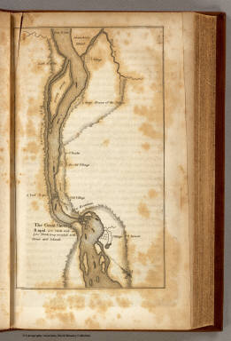
The Great Shoot or Rapid.
Publisher
Bradford and Inskeep
Author
[Allen, Paul, Biddle, Nicholas, Clark, William, Lewis, Meriwether]
Full Title
Mouth of Columbia River.
Publisher
Bradford and Inskeep
Author
Carey, Mathew
Full Title
The State of Ohio with part of Upper Canada, &c.
Publisher
Mathew Carey
Author
Herrith, Philura
Full Title
A Map of the British Possessions in North America, including Part of the United States: Compiled from the Latest Surveys. 1815. Philura Herrith.
Publisher
Manuscript
Author
Brue, Adrien Hubert, 1786-1832
Full Title
Carte encyprotype de l'Asie. Reduite de la carte sur 4 feuilles d'Aigle du meme auteur. Dediee et presentee a S.A.R. Monsieur, Comte d'Artois. Par H. Brue, Ingenieur Geographe. H. Brue direct. A Paris, Chez Desray ... (et) Goujon ..., 1814.
Publisher
Desray, Libraire-Editeur
Author
Brue, Adrien Hubert, 1786-1832
Full Title
Carte encyprotype de l'Asie. Dediee et presentee a S.A.R. Monsieur, Comte d'Artois. Par H. Brue, Ingenieur Geographe. (H. Brue dirext.) A Paris, Chez Desray ... (et) J. Goujon ..., 1814.
Publisher
Desray, Libraire-Editeur
Full Title
Asie 2e. feuille. (Par H. Brue, Ingenieur Geographe. H. Brue dirext. A Paris, Chez Desray ... (et) J. Goujon ..., 1814)
Publisher
Desray, Libraire-Editeur
Full Title
Asie 3e. feuille. (Par H. Brue, Ingenieur Geographe). H. Brue dirext. (A Paris, Chez Desray ... (et) J. Goujon ..., 1814)
Publisher
Desray, Libraire-Editeur
|