Who What Where WhenREMOVE |
Full Title
Connecticut. Entered ... 1836, by Eleazer Huntington ... Connecticut.
Publisher
Reed & Barber
Full Title
Middle States and part of the Southern. Entered ... 1836, by Eleazer Huntington ... Connecticut.
Publisher
Reed & Barber
Full Title
Western States. Entered ... 1836, by Eleazer Huntington ... Connecticut.
Publisher
Reed & Barber
Full Title
South America. Entered ... 1836, by Eleazer Huntington ... Connecticut.
Publisher
Reed & Barber
Full Title
Europe. Entered ... 1836, by Eleazer Huntington ... Connecticut.
Publisher
Reed & Barber
Full Title
Great Britain and Ireland. Entered ... 1836, by Eleazer Huntington ... Connecticut.
Publisher
Reed & Barber
Full Title
Asia. Entered ... 1836, by Eleazer Huntington ... Connecticut.
Publisher
Reed & Barber
Full Title
Africa and the Atlantic Ocean. Entered ... 1836, by Eleazer Huntington ... Connecticut.
Publisher
Reed & Barber
Full Title
Oceanica and comparative N. America & Asia. Entered ... 1836, by Eleazer Huntington ... Connecticut.
Publisher
Reed & Barber
Author
Willard, Emma
Full Title
(Covers to) Atlas to accompany a System of universal history; containing: I. A chronological picture of nations, or perspective sketch of the course of empire. II. The progressive geography of the World, in a series of maps, adapted to the different epochas of the history. By Emma Willard, Principal of Troy Female Seminary, and author of other geographical and historical works. Hartford: Published By F.J. Huntington. MDCCCXXXVI. Entered ... 1835, by F.J. Huntington ... Connecticut.
Publisher
F.J. Huntington
Author
Willard, Emma
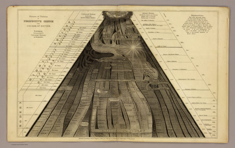
Full Title
Picture of nations or perspective sketch of the course of empire. To accompany Willard's Universal history in perspective. Entered ... 1835, by F.J. Huntington ... Connecticut. (1836)
Publisher
F.J. Huntington
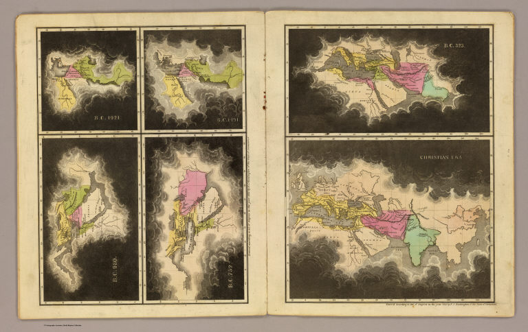
Full Title
B.C. 1921. B.C. 1491. B.C. 980. B.C. 752. B.C. 323. Christian era. Entered ... 1835, by F.J. Huntington ... Connecticut. (1836)
Publisher
F.J. Huntington
Full Title
A.D. 395. A.D. 1100. A.D. 1492. Entered ... 1835, by F.J. Huntington ... Connecticut. (1836)
Publisher
F.J. Huntington
Full Title
(The World). Entered ... 1835, by F.J. Huntington ... Connecticut. (1836)
Publisher
F.J. Huntington
Author
Colton, J. H.
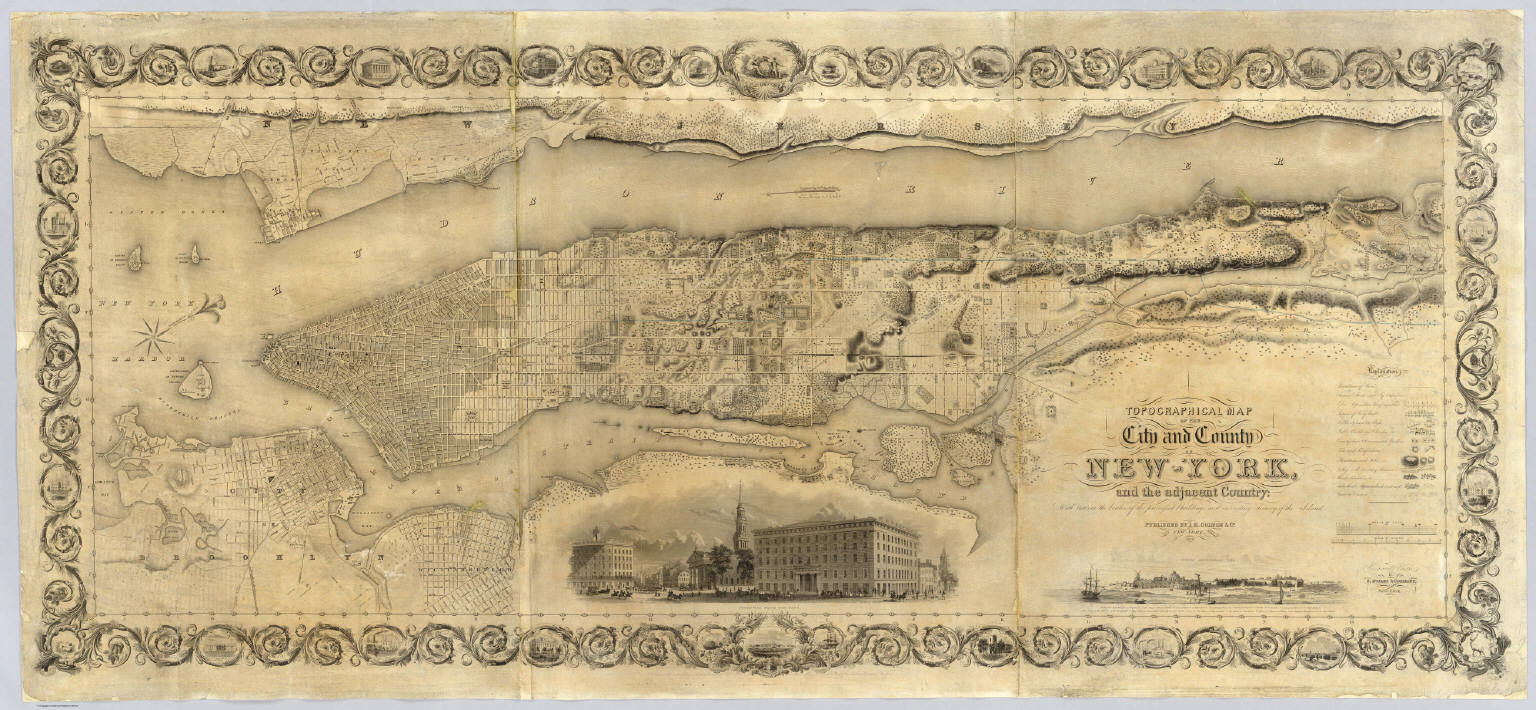
Full Title
Topographical Map Of The City and County Of New - York, and the adjacent Country: With Views in the border of the principal Buildings and interesting Scenery of the Island. Published By J.H. Colton & Co. No. 4 Spruce St. New-York. 1836. Engraved & Printed by S. Stiles & Company, New-York. Entered ... 1836, by J.H. Colton & Co. ... New York.
Publisher
J.H. Colton & Co.
Author
Norie, J.W.
Full Title
A New Chart of The Pacific Ocean, Exhibiting The Western Coast of America, From Cape Horn To Beerings Strait, The Eastern Shores of Asia Including Japan, China and Australia, and all the numerous Islands and known Dangers Situated in Polynesia and Australasia, Correctly Drawn And Regulated according to the most Approved and Modern Surveys and Astronomical Observations By J.W. Norie, Hydrographer, &c.&c. Additions 1836. Stephenson, Engraver. London. Published ... October 1st 1825, by J.W. Norie & Co. (with) seven inset maps listed in Notes. (Northern Sheet)
Publisher
J.W. Norie & Co.
Author
Norie, J.W.
Full Title
A New Chart of The Pacific Ocean, Exhibiting The Western Coast of America, From Cape Horn To Beerings Strait, The Eastern Shores of Asia Including Japan, China and Australia, and all the numerous Islands and known Dangers Situated in Polynesia and Australasia, Correctly Drawn And Regulated according to the most Approved and Modern Surveys and Astronomical Observations By J.W. Norie, Hydrographer, &c.&c. Additions 1836. Stephenson, Engraver. London. Published ... October 1st 1825, by J.W. Norie & Co. (with) seven inset maps listed in Notes. (Southern Sheet)
Publisher
J.W. Norie & Co.
Author
Norie, J.W.
Full Title
(Composite of) A New Chart of The Pacific Ocean, Exhibiting The Western Coast of America, From Cape Horn To Beerings Strait, The Eastern Shores of Asia Including Japan, China and Australia, and all the numerous Islands and known Dangers Situated in Polynesia and Australasia, Correctly Drawn And Regulated according to the most Approved and Modern Surveys and Astronomical Observations By J.W. Norie, Hydrographer, &c.&c. Additions 1836. Stephenson, Engraver. London. Published ... October 1st 1825, by J.W. Norie & Co. (with) seven inset maps listed in Notes. (Northern and Southern Sheets)
Publisher
J.W. Norie & Co.
Author
C. Smith & Son
Full Title
A Comparative Picture of the Principal Waterfalls in the World. London. C. smith & Son. 172 Strand. 1836.
Publisher
C. Smith & Son
Author
[Hammond, John T., Squire, B.S.]
Full Title
Squire's Map Of The State Of New Jersey. Drawn & Engraved by John T. Hammond, New-York, 1836. Entered ... 27th of July 1835 by B.S. Squire Jr. ... New York. (with 8 inset maps).
Publisher
B.S. Squire
Author
Gallatin, Albert
Full Title
Carte des Tribus Indiennnes de l'Amerique du Nord : vers 1600 A.D. ;e long de l'Atlantique ; et vers 1800 A.D. a l'Ouest. D'apres un dessin Mr. Gallatin.
Publisher
No Publisher
Author
Fisher, Samuel B.
Full Title
Map Of The First And Second Anthracite Coal Field. By Samuel B. Fisher Pottsville, Pennsylvania. 1836. Watson's Lith., Philada. Lithog. by J.F. & C.A. Watson, No. 62 Walnut Street, Philadelphia.
Publisher
Watson's Lith.
Author
[Mitchell, Samuel Augustus, Young, James H.]
Full Title
Mitchell's Reference & Distance Map Of The United States By J.H. Young. Published By S. Augustus Mitchell. Philadelphia For Sale By Mitchell & Hinman, No. 6 North Fifth Street 1836. Engraved by J.H. Young, F. Dankworth, E. Yeager & E. F. Woodward. Entered ... 1833 by S. Augustus Mitchell ... Pennsylvania ... (illustration) Designed by W. Mason. (inset) A General Map Of The United States with the contiguous British & Mexican Possessions. (with 12 additional inset maps).
Publisher
S.A. Mitchell
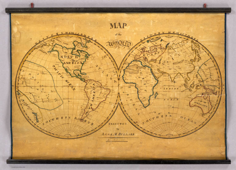
Author
Bullard, Anna M.
Full Title
Map of the World. Executed by Anna M. Bullard. Boston March 15, 1836. Western Hemisphere. Eastern Hemisphere.
Publisher
Manuscript
Author
[Goujon, J, Andriveau, J.]
Full Title
Tableau Comparatif et Figure de La Hauteur des Principales Montagnes et du Cours des Principaux Fleuves due Monde. Les Fleuves graves par Dumortier. Les Montagnes par A. Hocquart. La Lettre par Arnoul. Paris. Chez J. Goujon & J. Andriveau. Geographes - Editeurs. Rue du Bac, No. 6, Pres le Pont Royal. 1836.
Publisher
Goujon, J.; Andriveau, J.
Author
Anslin, M.
Full Title
The World. By M. Anslin. Western Hemisphere. Eastern Hemisphere.
Publisher
Manuscript.
Author
[Lancaster, Cyrus, Wilson, James]
Full Title
Wilson's New American Thirteen Inch Terrestrial Globe, Exhibiting with the Greatest Possible Accuracy, The Positions of the Principal Known Places of the Earth; with the Tracks of Various Circumnavigators, Together with New Discoveries and Political Alterations Down to the present Period: 1836. By Cyrus Lancaster, Albany St. N.Y. S. Wood & Sons Agents N. York.
Publisher
Cyrus Lancaster
Author
Tanner, Henry S.
Full Title
(Covers to) A New Universal Atlas Containing Maps of the various Empires, Kingdoms, States and Republics Of The World. With a special map of each of the United States, Plans of Cities &c. Comprehended in seventy sheets and forming a series of One Hundred And Seventeen Maps, Plans And Sections, By H.S. Tanner ... Philadelphia, Published By The Author. 1836. (title page by) J. Knight Sc.
Publisher
H.S. Tanner
Author
Tanner, Henry S.
Full Title
(Title Page to) A New Universal Atlas Containing Maps of the various Empires, Kingdoms, States and Republics Of The World. With a special map of each of the United States, Plans of Cities &c. Comprehended in seventy sheets and forming a series of One Hundred And Seventeen Maps, Plans And Sections, By H.S. Tanner ... Philadelphia, Published By The Author. 1836. (title page by) J. Knight Sc.
Publisher
H.S. Tanner
Author
Tanner, Henry S.
Full Title
(Contents to) A New Universal Atlas Containing Maps of the various Empires, Kingdoms, States and Republics Of The World. With a special map of each of the United States, Plans of Cities &c. Comprehended in seventy sheets and forming a series of One Hundred And Seventeen Maps, Plans And Sections, By H.S. Tanner ... Philadelphia, Published By The Author. 1836. (title page by) J. Knight Sc.
Publisher
H.S. Tanner
Author
Tanner, Henry S.
Full Title
(Author's Notice to) A New Universal Atlas Containing Maps of the various Empires, Kingdoms, States and Republics Of The World. With a special map of each of the United States, Plans of Cities &c. Comprehended in seventy sheets and forming a series of One Hundred And Seventeen Maps, Plans And Sections, By H.S. Tanner ... Philadelphia, Published By The Author. 1836. (title page by) J. Knight Sc.
Publisher
H.S. Tanner
Author
Tanner, Henry S.
Full Title
(Index to) A New Universal Atlas Containing Maps of the various Empires, Kingdoms, States and Republics Of The World. With a special map of each of the United States, Plans of Cities &c. Comprehended in seventy sheets and forming a series of One Hundred And Seventeen Maps, Plans And Sections, By H.S. Tanner ... Philadelphia, Published By The Author. 1836. (title page by) J. Knight Sc.
Publisher
H.S. Tanner
Author
Tanner, Henry S.
Full Title
A New Map Of The World on the Globular Projection By H.S. Tanner. Philadelphia. Published by H.S. Tanner 1833. Engd. by E.B. Dawson. Tanner's Universal Atlas.
Publisher
H.S. Tanner
Author
Tanner, Henry S.
Full Title
North America. Entered ... 1836 by H.S. Tanner ... Pennsylvania. Philadelphia: Published by H.S. Tanner. (above neat line) Tanner's Universal Atlas.
Publisher
H.S. Tanner
Author
Tanner, Henry S.
Full Title
Lower Canada. J. Knight Sc. Published by H.S. Tanner, Philadelphia. (with) Nova Scotia New Brunswick &c. (above neat line) Tanner's Universal Atlas.
Publisher
H.S. Tanner
Author
Tanner, Henry S.
Full Title
Upper Canada. Published by H.S. Tanner, Philadelphia. (with) inset map of Lake Superior. (above neat line) Tanner's Universal Atlas.
Publisher
H.S. Tanner
Author
Tanner, Henry S.
Full Title
United States. Published by H.S. Tanner, Philadelphia. Entered ... 1835 by H.S. Tanner ... Pennsylvania. (above neat line) Tanner's Universal Atlas.
Publisher
H.S. Tanner
Author
Tanner, Henry S.
Full Title
A New Map of Maine By H.S. Tanner. Entered ... 1833 by H.S. Tanner ... Pennsylvania. Philadelphia: Published by H.S. Tanner. (above neat line) Tanner's Universal Atlas.
Publisher
H.S. Tanner
Author
Tanner, Henry S.
Full Title
New Hampshire & Vermont By H.S. Tanner. Engraved by J. & W.W. Warr. Entered ... 1833 by H.S. Tanner ... Pennsylvania. Published by H.S. Tanner Philadelphia. (above neat line) Tanner's Universal Atlas.
Publisher
H.S. Tanner
Author
Tanner, Henry S.
Full Title
Massachusetts And Rhode Island: By H.S. Tanner. Engraved by J. & W.W. Warr. (with) Boston. Entered ... 1833 by H.S. Tanner ... Pennsylvania. Philadelphia Published by H.S. Tanner. (above neat line) Tanner's Universal Atlas.
Publisher
H.S. Tanner
Author
Tanner, Henry S.
Full Title
Connecticut By H.S. Tanner. Engraved by E.B. Dawson. (with) two inset maps Hartford &c. and New Haven &c. Entered ... 1834 by H.S. Tanner ... Pennsylvania. Philadelphia: Published by H.S. Tanner. (above neat line) Tanner's Universal Atlas.
Publisher
H.S. Tanner
Author
Tanner, Henry S.
Full Title
A New Map Of New York with its Canals, Roads & distances from Place to Place along the Stage & Steam-boat Routes. Engraved by W. Brose, Philadelphia. Entered ... 1833 by H.S. Tanner ... Pennsylvania. Published by H.S. Tanner, Philadelphia. (above neat line) Tanner's Universal Atlas.
Publisher
H.S. Tanner
Author
Tanner, Henry S.
Full Title
New Jersey Reduced From T. Gordon's Map By H.S. Tanner. J. Knight Sc. Entered ... 1833 by H.S. Tanner ... Pennsylvania. Published by H.S. Tanner, Philadelphia. (above neat line) Tanner's Universal Atlas.
Publisher
H.S. Tanner
Author
Tanner, Henry S.
Full Title
A New Map Of Pennsylvania with its Canals, Rail-Roads & Distances from Place to Place along the Stage Roads. By H.S. Tanner. Engraved by W. Brose, Philadelphia. Entered ... 1833 by H.S. Tanner ... Pennsylvania. Published by H.S. Tanner, Philadelphia. (above neat line) Tanner's Universal Atlas.
Publisher
H.S. Tanner
Author
Tanner, Henry S.
Full Title
A New Map Of Maryland and Delaware with their Canals, Roads & Distances. by H.S. Tanner. E. Gillingham Sc. (with) Baltimore. Entered ... 1833 by H.S. Tanner ... Pennsylvania. Published by H.S. Tanner, Philadelphia. (above neat line) Tanner's Universal Atlas.
Publisher
H.S. Tanner
Author
Tanner, Henry S.
Full Title
A New Map Of Virginia With Its Canals, Roads & Distances from place to place, along the Stage & Steam Boat Routes. by H.S. Tanner. Engraved by W. Brose, Philadelphia. Entered ... 1833 by H.S. Tanner ... Pennsylvania. Published by H.S. Tanner, No. 144 Chesnut St. Philadelphia. (above neat line) Tanner's Universal Atlas.
Publisher
H.S. Tanner
Author
Tanner, Henry S.
Full Title
A New Map Of Nth. Carolina With Its Canals, Roads & Distances from place to place, along the Stage & Steam Boat Routes. by H.S. Tanner. (with) two inset maps: Gold Region and the Neuse River. Engraved by W. Brose, Philadelphia. Entered ... 1833 by H.S. Tanner ... Pennsylvania. Published by H.S. Tanner, No. 144 Chesnut St. Philadelphia. (above neat line) Tanner's Universal Atlas.
Publisher
H.S. Tanner
Author
Tanner, Henry S.
Full Title
A New Map Of South Carolina With Its Canals, Roads & Distances from place to place, along the Stage & Steam Boat Routes. by H.S. Tanner. (with) Charleston. Engraved by J. & W.W. Warr. Entered ... 1833 by H.S. Tanner ... Pennsylvania. Published by H.S. Tanner, No. 144 Chesnut St. Philadelphia. (above neat line) Tanner's Universal Atlas.
Publisher
H.S. Tanner
Author
Tanner, Henry S.
Full Title
A New Map Of Georgia With Its Roads & Distances by H.S. Tanner. Engraved by J. Knight. Entered ... 1833 by H.S. Tanner ... Pennsylvania. Published by H.S. Tanner, Philadelphia. (above neat line) Tanner's Universal Atlas.
Publisher
H.S. Tanner
|