Who What Where WhenREMOVE |
Author
Tanner, Henry S.
Full Title
(Covers to) Kentucky And Tennessee. By H.S. Tanner. No. 201 Broadway, N. York, 1850. Engraved by H.S. Tanner & Assistants.
Publisher
H.S. Tanner
Author
Tanner, Henry S.
Full Title
Kentucky And Tennessee. By H.S. Tanner. No. 201 Broadway, N. York, 1850. Engraved by H.S. Tanner & Assistants.
Publisher
H.S. Tanner
Author
U.S. War Department, Topographical Engineers
Full Title
Map Of The United States And Their Territories Between The Mississippi and the Pacific Ocean And Of Part of Mexico. Compiled in the Bureau of the Corps of Topogl. Engs. under a Resolution of the U.S. Senate. From the best authorities which could be obtained. 1850. Engraved by Sherman and Smith, New-York.
Publisher
Sherman and Smith
Author
Case Tiffany & Company
Full Title
Map of the United States. Hartd., Published By Case Tiffany & Company 1850.
Publisher
Case Tiffany & Company
Author
[Mitchell, Samuel Augustus, Dorby & Miller]
Full Title
Map Of Mexico, Including Yucatan & Upper California, exhibiting The Chief Cities And Towns, The Principal Travelling Routes &c. Philadelphia. Published by Dorby & Miller. Auburn, New York. 1850. Entered ... 1847 by S. Augustus Mitchell ... Pennsylva. (inset map) Battle Field Of Monterey.
Publisher
Dorby & Miller
Author
[Burr, David H, Haven, J.]
Full Title
The World, on Mercator's Projection: By David H. Burr. Showing the different Routes to California, and distance by each; Routes of different Navigators, Route of the contemplated Pacific R.Road, Distances to China, Europe, &c. Published by J. Haven, 86 State St. Boston; 1850. Entered ... 1850 by John Hansen ... Massachusetts. (with) two inset maps: Map of the Nicaragaua Route and A Map of the Proposed Rail Road from St. Louis To The Bay Of St. Francisco, Compiled from the Maps and Reports of Col. Fremont, by W.L. Dearborn, Civil Engineer.
Publisher
J. Haven
Author
Moore, James B.
Full Title
Chart Prepared By James B. Moore, To Accompany His Memorial To Congress Respecting the subject of Steam Communication with China, Japan &c. 1850. Engr. on Stone by H. Gollmer, Cin. (inset map) Harbour of San Francisco California.
Publisher
H. Gollmer
Author
Williamson, Jessie E.
Full Title
Map of North America. Jessie E. Williamson. 1850.
Publisher
Manuscript
Author
Williamson, Jessie E.
Full Title
Map of South America. Jessie E. Williamson. 1850.
Publisher
Manuscript
Author
[Mitchell, Samuel Augustus, Drake, Ira S.]
Full Title
(Covers to) Mitchell's New Traveller's Guide Through The United States, Containing The Principal Cities, Towns &c. ... Illustrated By An Accurate Map Of The United States. Philadelphia: Thomas, Cowperthwait & Co. 1850. (on verso) Entered ... 1848, by Thomas, Cowperthwait & Co. ... Pennsylvania. Stereotyped by J. Fagan. Printed by Smith & Peters. (with map) Mitchell's New Traveller's Guide Through The United States, Showing the Rail Roads, Canals, Stage Roads &c. ... Drawn and Engraved by Ira S. Drake. Philadelphia 1849 Published by Thomas, Cowperthwait & Co. (with 5 inset maps).
Publisher
Thomas, Cowperthwait & Co.
Author
[Mitchell, Samuel Augustus, Drake, Ira S.]
Full Title
(Title Page to) Mitchell's New Traveller's Guide Through The United States, Containing The Principal Cities, Towns &c. ... Illustrated By An Accurate Map Of The United States. Philadelphia: Thomas, Cowperthwait & Co. 1850. (on verso) Entered ... 1848, by Thomas, Cowperthwait & Co. ... Pennsylvania. Stereotyped by J. Fagan. Printed by Smith & Peters. (with map) Mitchell's New Traveller's Guide Through The United States, Showing the Rail Roads, Canals, Stage Roads &c. ... Drawn and Engraved by Ira S. Drake. Philadelphia 1849 Published by Thomas, Cowperthwait & Co. (with 5 inset maps).
Publisher
Thomas, Cowperthwait & Co.
Author
[Mitchell, Samuel Augustus, Drake, Ira S.]
Full Title
Mitchell's New Traveller's Guide Through The United States, Showing the Rail Roads, Canals, Stage Roads &c. ... Drawn and Engraved by Ira S. Drake. Philadelphia 1849 Published by Thomas, Cowperthwait & Co. (with 5 inset maps). (with text) Mitchell's New Traveller's Guide Through The United States, Containing The Principal Cities, Towns &c. ... Illustrated By An Accurate Map Of The United States. Philadelphia: Thomas, Cowperthwait & Co. 1850. (on verso) Entered ... 1848, by Thomas, Cowperthwait & Co. ... Pennsylvania. Stereotyped by J. Fagan. Printed by Smith & Peters.
Publisher
Thomas, Cowperthwait & Co.
Author
Mitchell, Samuel Augustus
Full Title
(Covers to) The Tourist's Pocket Map Of The State Of Kentucky Exhibiting Its Internal Improvements Roads Distances &c. by J.H. Young. Philadelphia: Published By S. Augustus Mitchell. 1850. Sold By Thomas, Cowperthwait & Co. No. 253 Market Street. Entered ... 1834 by S. Augustus Mitchell ... Pennsylvania. Engraved by Edward Yeager. (inset) Vicinity Of Louisville. (inset) Vicinity Of Frankfort & Lexington.
Publisher
Samuel Augustus Mitchell
Author
Mitchell, Samuel Augustus
Full Title
The Tourist's Pocket Map Of The State Of Kentucky Exhibiting Its Internal Improvements Roads Distances &c. by J.H. Young. Philadelphia: Published By S. Augustus Mitchell. 1850. Sold By Thomas, Cowperthwait & Co. No. 253 Market Street. Entered ... 1834 by S. Augustus Mitchell ... Pennsylvania. Engraved by Edward Yeager. (inset) Vicinity Of Louisville. (inset) Vicinity Of Frankfort & Lexington.
Publisher
Samuel Augustus Mitchell
Author
Smith, J. Calvin
Full Title
(Covers to) Sherman & Smith's Railroad, Steam Boat & Stage Route Map Of New England, New-York And Canada. By J. Calvin Smith. Published by Sherman & Smith 135 Broadway. N.Y. MDCCCL. Entered ... 1850 by Sherman & Smith ... (inset) 15 Miles Around Boston. (inset) 15 Miles Around New York.
Publisher
Sherman & Smith
Author
Smith, J. Calvin
Full Title
Sherman & Smith's Railroad, Steam Boat & Stage Route Map Of New England, New-York And Canada. By J. Calvin Smith. Published by Sherman & Smith 135 Broadway. N.Y. MDCCCL. Entered ... 1850 by Sherman & Smith ... (inset) 15 Miles Around Boston. (inset) 15 Miles Around New York.
Publisher
Sherman & Smith
Author
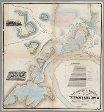
[Franks, Theo., Brady's Bend Iron Co.]
Full Title
Topographical & Geological Map Of The Property Belonging To The Brady's Bend Iron Co. Located In Armstrong County Pa. by Theo. Franks Civil Engineer. From Plan drawn by R. Jennings, Brady's Bend. Wm Schuchman, lith. 3d St, Pittsburgh, Pa. (inset) Geological Section From Notes By Prof. Shepherd.
Publisher
Wm. Schuchman lith.
Author
[Kollner, Augustus, Sunbury and Erie Railroad]
Full Title
Pennsylvania's Great Highway And Its Tributary Lines. Engraved & printed at A. Kollner's Litho Establisht. cor. of Secd. & Dock Sts. Phila.
Publisher
A. Kollner's Litho Establishment
Author
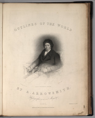
Arrowsmith, Aaron Jr.
Full Title
(Covers to) Outlines Of The World. By A. Arrowsmith, Hydrographer to His Majesty. 1850. Published Jany st. 1847, by G.F. Cruchley, Mapseller, 81 Fleet Street, London. Addition to 1850. (title page portrait) Aaron Arrowsmith Esquire. H.W. Pickersgill A.R.A. Pinxt. T.A. Dean Sculpt.
Publisher
G.F. Cruchley
Author
Arrowsmith, Aaron Jr.
Full Title
(Title Page to) Outlines Of The World. By A. Arrowsmith, Hydrographer to His Majesty. 1850. Published Jany st. 1847, by G.F. Cruchley, Mapseller, 81 Fleet Street, London. Addition to 1850. (title page portrait) Aaron Arrowsmith Esquire. H.W. Pickersgill A.R.A. Pinxt. T.A. Dean Sculpt.
Publisher
G.F. Cruchley
Author
Arrowsmith, Aaron Jr.
Full Title
England. Re- Published by G.F. Cruchley, Mapseller, 81 Fleet Street. (to accompany) Outlines Of The World. By A. Arrowsmith, Hydrographer to His Majesty. 1850.
Publisher
G.F. Cruchley
Author
Arrowsmith, Aaron Jr.
Full Title
Holland. Re- Published, Jany st. 1845, by G.F. Cruchley, Mapseller, 81 Fleet Street, London. (to accompany) Outlines Of The World. By A. Arrowsmith, Hydrographer to His Majesty. 1850.
Publisher
G.F. Cruchley
Author
Arrowsmith, Aaron Jr.
Full Title
Holland and Belgium. Re- Published by G.F. Cruchley, Mapseller, 81 Fleet Street. (to accompany) Outlines Of The World. By A. Arrowsmith, Hydrographer to His Majesty. 1850.
Publisher
G.F. Cruchley
Author
Arrowsmith, Aaron Jr.
Full Title
France and Belgium. Re- Published by G.F. Cruchley, Mapseller, 81 Fleet Street. (to accompany) Outlines Of The World. By A. Arrowsmith, Hydrographer to His Majesty. 1850.
Publisher
G.F. Cruchley
Author
Arrowsmith, Aaron Jr.
Full Title
Germany. Re- Published by G.F. Cruchley, Mapseller, 81 Fleet Street. (to accompany) Outlines Of The World. By A. Arrowsmith, Hydrographer to His Majesty. 1850.
Publisher
G.F. Cruchley
Author
Arrowsmith, Aaron Jr.
Full Title
N. Italy. Re- Published by G.F. Cruchley, Mapseller, 81 Fleet Street. (to accompany) Outlines Of The World. By A. Arrowsmith, Hydrographer to His Majesty. 1850.
Publisher
G.F. Cruchley
Author
Mitchell, Samuel Augustus
Full Title
(Covers to) A New Universal Atlas Containing Maps of the various Empires, Kingdoms, States and Republics Of The World. With a special map of each of the United States, Plans of Cities &c. Comprehended in seventy sheets and forming a series of One Hundred And Seventeen Maps, Plans And Sections ... Philadelphia, Published By Thomas, Cowperthwait & Co. No. 253 Market Street. 1850. Entered ... 1850, by Thomas, Cowperthwait & Co. ... Pennsylvania. (title page by) J. Knight Sc.
Publisher
Thomas, Cowperthwait & Co.
Author
Mitchell, Samuel Augustus
Full Title
(Text Page) (Anonymous Handwritten Notes about this Atlas).
Publisher
Thomas, Cowperthwait & Co.
Author
Mitchell, Samuel Augustus
Full Title
(Frontispiece) Lengths of the Principal Rivers in the World. Heights of the Principal Mountains in the World.
Publisher
Thomas, Cowperthwait & Co.
Author
Mitchell, Samuel Augustus
Full Title
(Title Page) A New Universal Atlas Containing Maps of the various Empires, Kingdoms, States and Republics Of The World. With a special map of each of the United States, Plans of Cities &c. Comprehended in seventy sheets and forming a series of One Hundred And Seventeen Maps, Plans And Sections ... Philadelphia, Published By Thomas, Cowperthwait & Co. No. 253 Market Street. 1850. Entered ... 1850, by Thomas, Cowperthwait & Co. ... Pennsylvania. (title page by) J. Knight Sc.
Publisher
Thomas, Cowperthwait & Co.
Author
Mitchell, Samuel Augustus
Full Title
(Index Page) Table of Contents.
Publisher
Thomas, Cowperthwait & Co.
Author
Mitchell, Samuel Augustus
Full Title
A New Map of the World on the Globular Projection. Western Hemisphere. Eastern Hemisphere.
Publisher
Thomas, Cowperthwait & Co.
Author
Mitchell, Samuel Augustus
Full Title
North America.
Publisher
Thomas, Cowperthwait & Co.
Author
Mitchell, Samuel Augustus
Full Title
Canada East, Formerly Lower Canada. (inset) Nova Scotia, New Brunswick &c.
Publisher
Thomas, Cowperthwait & Co.
Author
Mitchell, Samuel Augustus
Full Title
Canada West, Formerly Upper Canada. (inset) Lake Superior.
Publisher
Thomas, Cowperthwait & Co.
Author
Mitchell, Samuel Augustus
Full Title
A New Map of the United States of America by J.H. Young. (insets) Gold Region of California. District of Columbia.
Publisher
Thomas, Cowperthwait & Co.
Author
Mitchell, Samuel Augustus
Full Title
Map of the United States of America by J.H. Young. (insets) Gold Region of California. District of Columbia.
Publisher
Thomas, Cowperthwait & Co.
Author
Mitchell, Samuel Augustus
Full Title
A New Map of Maine.
Publisher
Thomas, Cowperthwait & Co.
Author
Mitchell, Samuel Augustus
Full Title
New Hampshire and Vermont.
Publisher
Thomas, Cowperthwait & Co.
Author
Mitchell, Samuel Augustus
Full Title
Massachusetts and Rhode Island.
Publisher
Thomas, Cowperthwait & Co.
Author
Mitchell, Samuel Augustus
Full Title
Connecticut (insets) Hartford &c. New Haven &c.
Publisher
Thomas, Cowperthwait & Co.
Author
Mitchell, Samuel Augustus
Full Title
A New Map of New York.
Publisher
Thomas, Cowperthwait & Co.
Author
Mitchell, Samuel Augustus
Full Title
City of New York.
Publisher
Thomas, Cowperthwait & Co.
Author
Mitchell, Samuel Augustus
Full Title
New Jersey Reduced from T. Gordon's Map.
Publisher
Thomas, Cowperthwait & Co.
Author
Mitchell, Samuel Augustus
Full Title
A New Map of Pennsylvania with its Canals, Railroads, &c.
Publisher
Thomas, Cowperthwait & Co.
Author
Mitchell, Samuel Augustus
Full Title
Philadelphia. (inset) Baltimore.
Publisher
Thomas, Cowperthwait & Co.
Author
Mitchell, Samuel Augustus
Full Title
New Map of Maryland and Delaware with their Canals, Railroads & Distances. (inset) Baltimore.
Publisher
Thomas, Cowperthwait & Co.
Author
Mitchell, Samuel Augustus
Full Title
Country between Washington (DC) & Manassas Junction. Topographical Map of the Country between Fortress Monroe & Richmond.
Publisher
Thomas, Cowperthwait & Co.
Author
Mitchell, Samuel Augustus
Full Title
City of Washington.
Publisher
Thomas, Cowperthwait & Co.
|