Who What Where WhenREMOVEWHATShow More |
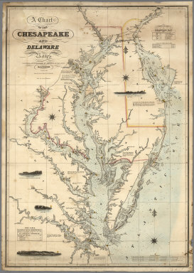
Author
Lucas, Fielding Jr.
Full Title
A Chart of the Chesapeake And Delaware Bays Compiled And Published By Fielding Lucas Junr. Baltimore. Corrected_1862. Engraved by John and William W. Warr Philadelphia. Sold by Lucas Brothers. Drawn by F. Lucas Jr. Entered ... 1852 by Fielding Lucas Jr. ... Maryland.
Publisher
Fielding, Lucas Jr.
Author
Mouchez, Ernest Amedee Barthelemy
Full Title
Carte de la Republique du Paraguay : cours du Parana et du Paraguay (Amerique meridionale). Dressee par E. Mouchez Lieutt. de Vau. commt. l'Aviso à vapeur le Bisson a l'aide des observations faites et des documents recueillis sur les lieux pendant les trois voyages du Bisson en 1857-58-59. Depot des cartes et plans de la marine. 1862. Paris : Imp. Aug. Bry, R. du Bac 114. PRIX. Grave par Delamare. Deux France.
Publisher
Depot des Cartes et Plans de la Marine
Author
[Chace, J., Walling, H. F.]
Full Title
Map Of The State Of Maine. From Surveys made by the United States Coast Survey, from the British and American Boundary Commissioners Survey, from the State Land Surveys, the New Brunswick Provincial Surveys, and from Actual Surveys by H.F. Walling & J. Chace Jr. ... H.F. Walling. Published By J. Chace Jr. & Co. 55 Exchange St. Portland. 1862. M. Clemens, T.W. Baker, Assistant Draughtsmen. W. Hatfield, Engraver, 132 Nassau St. J. Chace Jr., Sanborn & Carter, 55 Exchange St. Portland. Bailey & Noyes, 56 & 58 Exch. St. Portland. Entered ... by H.F. Walling & J. Chace Jr. ... New York. (inset) Map Of The United States Of America By H.F. Walling, 1861. Engraved by D. Griffing Johnson, N. York. (with 28 smaller inset maps).
Publisher
J. Chace Jr. & Co.
Author
[Smith, J. Calvin, Smith, Robert P.]
Full Title
The New Naval And Military Map Of The United States. By J. Calvin Smith, Author Of Harper's Gazetteer, Colton's County Map Of The U.S. Travellers' Guide &c. 1862. J. Baker & Co. Publishers. J.M. Atwood, Map Engraver 517 Minor St. Philadelphia, Pa. Entered ... 1862 by Robert P. Smith ... Pennsylvania. (with 5 inset maps and 3 profiles).
Publisher
J. Baker
Author
[Smith, Robert P., Taintor, S. & Co.]
Full Title
The Washington Map of the United States By the Superintendent U.S. National Observatory, Washington D.C. 1862. S. Taintor & Co. 517, 519 & 521 Minor St. Philadelphia. Publishers. Holmes, Harrison & Co. London. Entered ... 1861 by Robert P. Smith ... Pennsylvania. (with) Five inset maps: The World and four thematic maps of the US showing Plants and Trees, Zoological Distribution, Temperature and Rainfall, and Geology.
Publisher
S. Taintor & Co
Author
[Smith, Robert P., Taintor, S. & Co.]
Full Title
The Washington Map Of The United States. By the Superintendent U.S. National Observatory, Washington D.C. 1862. S. Taintor & Co. Rochester, New York & Philadelphia, Pa. Publishers. Holmes, Harrison & Co. London. Entered ... 1861 by Robert P. Smith ... Pennsylvania. Printed by T.S. Wagner, 38 Hudson St. Phila. (with 6 inset maps and 3 profiles).
Publisher
S. Taintor & Co
Author
Monk, Jacob
Full Title
The Continental Map Of North America. Compiled from recent Government Surveys and other authentic sources. Designed & Published by Jacob Monk Philadelphia, 1862. Drawn Engraved & Printed by A. Hoen & Co. Baltimore. Entered ... 1862 by Jacob Monk ... Maryland. (inset) New Map Of The World on Mercators Projection ... (with 3 additional inset maps and 1 profile).
Publisher
Jacob Monk
Author
Mallory, C.A.
Full Title
(Cover to) Part of the North Bank of the Rappahannock River showing the approaches to Fredericksburg, prepared under the direction of Capt. R.S. Williamson & 1st Lt. Nicholas Bowen ... for the use of the Army of the Potomac compiled by Fred. Churchill Vol. A.D.C. U.S. Coast Survey Chart of the Rappahannock River Surveys and Reconnoissances by C.A. Mallory, Chas. Shoemacker, L.C. Oswell, H.H. Marvin, Geo. F. Lathrop, Assistants. Drawn by C.A. Mallory. Reduced and photographed by L.E. Walker, Treasy. Dept.
Publisher
U.S. Treasury Dept.
Author
Mallory, C.A.
Full Title
Part of the North Bank of the Rappahannock River showing the approaches to Fredericksburg, prepared under the direction of Capt. R.S. Williamson & 1st Lt. Nicholas Bowen ... for the use of the Army of the Potomac compiled by Fred. Churchill Vol. A.D.C. U.S. Coast Survey Chart of the Rappahannock River Surveys and Reconnoissances by C.A. Mallory, Chas. Shoemacker, L.C. Oswell, H.H. Marvin, Geo. F. Lathrop, Assistants. Drawn by C.A. Mallory. Reduced and photographed by L.E. Walker, Treasy. Dept.
Publisher
U.S. Treasury Dept.
Author
Matz, Otto H.
Full Title
(Cover to) Map Of The Country Between Monterey, Tenn. & Corinth, Miss. showing The Lines Of Entrenchments Made & The Routes Followed by The U.S. Forces under the Command of Maj. Genl. Halleck, U.S. Army, In Their Advance Upon Corinth, In May 1862: Surveyed under the direction of Col Geo. Thom, A.D.C. & Chief Of Topl Engrs. Department Of The Mississippi, by Lieuts. Fred. Schraag and C.L. Spangenberg Asst. Topl. Engrs. and drawn by Lieut. Otto H. Matz Asst. Topl. Engr. Lith of J. Bien, 180 Broadway N.Y.
Publisher
J. Bien
Author
Matz, Otto H.
Full Title
Map Of The Country Between Monterey, Tenn. & Corinth, Miss. showing The Lines Of Entrenchments Made & The Routes Followed by The U.S. Forces under the Command of Maj. Genl. Halleck, U.S. Army, In Their Advance Upon Corinth, In May 1862: Surveyed under the direction of Col Geo. Thom, A.D.C. & Chief Of Topl Engrs. Department Of The Mississippi, by Lieuts. Fred. Schraag and C.L. Spangenberg Asst. Topl. Engrs. and drawn by Lieut. Otto H. Matz Asst. Topl. Engr. Lith of J. Bien, 180 Broadway N.Y.
Publisher
J. Bien
Author
Matz, Otto H.
Full Title
Map Of The Field Of Shiloh, Near Pittsburgh Landing, Tenn. Shewing The Position of the U.S. Forces under the Command Of Maj. Genl. U.S. Grant U.S. Vol. And Maj. Genl. D.C. Buell U.S. Vol. On The 6th And 7th of April 1862. Surveyed Under The Direction Of Col. Geo Thom. Chief of Topl. Engrs. Drawn by Otto H. Matz, Asst. Topl. Engr. Lith. by Chas. Robyn & Co. cor. Chestnut and 3d St, St. Louis Mo.
Publisher
Chas. Robyn & Co.
Author
Prang, L. & Co.
Full Title
War Telegram Marking Map. L. Prang & Co. Print Publishers, 159, Washington St. Boston ... Entered ... 1862 by L. Prang & Co. ... Massachusetts.
Publisher
L. Prang
Author
Abbot, Henry L.
Full Title
Official Plan of The Siege Of Yorktown Va. Conducted by the Army of the Potomac under the command of Maj. Gen. George B. McClellan U.S.A. April 5th to May 3rd 1862. Prepared under the direction of Brig. Gen J.G. Barnard Chief Engr. by Lieut. Henry L. Abbot Top. Engrs. A.D.C. ... Lith. by J.F. Gedney, Washn. Chas. G. Krebs, Engr.
Publisher
J.F. Gedney
Author
Abbot, Henry L.
Full Title
Campaign Map, Army Of The Potomac. Map No. 3 White House To Harrisons Landing. Prepared By Command Of Maj. Gen. George B. McClellan, U.S.A. Commanding Army Of The Potomac Brig. Gen. A.A. Humphreys ... Compilation under the Direction of Brig. Gen. A.A. Humphreys, By Capt. H.L. Abbot, Top. Engrs. Engraved by W.H. Dougal.
Publisher
U.S.
Author
Abbot, Henry L.
Full Title
Campaign Map, Army Of The Potomac. Map No. 2 Williamsburg To White House. Prepared By Command Of Maj. Gen. George B. McClellan, U.S.A. Commanding Army Of The Potomac Brig. Gen. A.A. Humphreys ... Compilation under the Direction of Brig. Gen. A.A. Humphreys, By Capt. H.L. Abbot, Top. Engrs. Engraved by W.H. Dougal.
Publisher
U.S.
Author
Abbot, Henry L.
Full Title
Campaign Maps, Army Of The Potomac. Map No. 1 Yorktown To Williamsburg. Prepared By Command Of Maj. Gen. George B. McClellan U.S.A. Commanding Army Of The Potomac Brig. Gen. A.A. Humphreys ... Compilation under the Direction of Brig. Gen. A.A. Humphreys, By Capt. H.L. Abbot, Top. Engrs. Engraved by W.H. Dougal.
Publisher
U.S.
Author
[Asher & Company, Russell, Benjamin B.]
Full Title
(Covers to) The Historical War Map. Asher & Co. Entered ... 1862, by Asher & Co. ... Indiana. E.R. Jewett & Co. Engravers, Buffalo, N.Y.
Publisher
Benjamin B. Russell
Author
[Asher & Company, Russell, Benjamin B.]
Full Title
The Historical War Map. Asher & Co. Entered ... 1862, by Asher & Co. ... Indiana. E.R. Jewett & Co. Engravers, Buffalo, N.Y.
Publisher
Benjamin B. Russell
Author
Lloyd, J. T.
Full Title
(Covers to) Lloyd's official map of the State of Virginia from actual surveys by order of the Executive 1828 & 1859. Corrected and revised by J.T. Lloyd to 1862, from surveys made by Capt. W. Angelo Powell, of the U.S. Topographical Engineers of Gen. Rosencrans' Staff. Price 25cts. ... J.T. Lloyd, Publisher, 164 Broadway, New York ... Entered ... 1861 by J.T. Lloyd ... New York.
Publisher
J.T. Lloyd
Author
Lloyd, J. T.
Full Title
Lloyd's official map of the State of Virginia from actual surveys by order of the Executive 1828 & 1859. Corrected and revised by J.T. Lloyd to 1862, from surveys made by Capt. W. Angelo Powell, of the U.S. Topographical Engineers of Gen. Rosencrans' Staff. Price 25cts. ... J.T. Lloyd, Publisher, 164 Broadway, New York ... Entered ... 1861 by J.T. Lloyd ... New York.
Publisher
J.T. Lloyd
Author
[Bowen, Bart, Bowen, William, Lloyd, J. T.]
Full Title
Lloyd's map of the Lower Mississippi River from St. Louis to the Gulf of Mexico. Compiled from government surveys in the Topographical Bureau, Washington, D.C. Revised and corrected to the present time by Captains Bart and William Bowen, pilots of twenty years' experience on that River. Exhibiting the sugar and cotton plantations, cities, towns, landings, sand bars, islands, bluffs, bayous, cut-offs, the steamboat channel, mileage, fortifications, railroads. &c. along the River. J.T. Lloyd, Publisher. 164 Broadway, New York 1862. Entered ... 1862, by J.T. Lloyd ... New York.
Publisher
J.T. Lloyd
Author
Johnson, A.J.
Full Title
Johnson's Map of the Vicinity of Richmond, and Peninsular Campaign in Virginia. Showing also the Interesting Localities along the James, Chickahominy, and York Rivers. Compiled from the Official Maps of the War Department. By Johnson and Ward.
Publisher
Johnson and Ward
Author
[Bridgens, H.F., Fagan, L.]
Full Title
Plan of the City of Reading, Compiled by H.F.Bridgens, July 1860.
Publisher
H.F. Bridgens
Author
[Bridgens, H.F., Fagan, L.]
Full Title
Plan of the Borough of Bernville, Septr. 1861.
Publisher
H.F. Bridgens
Author
[Bridgens, H.F., Fagan, L.]
Full Title
Plan of Boyertown. Octr. 1861.
Publisher
H.F. Bridgens
Author
[Bridgens, H.F., Fagan, L.]
Full Title
Plan of the Borough of Hamburg, July 1861.
Publisher
H.F. Bridgens
Author
[Bridgens, H.F., Fagan, L.]
Full Title
Plan of Borough of Kutztown, August 1861.
Publisher
H.F. Bridgens
Author
[Bridgens, H.F., Fagan, L.]
Full Title
Plan of Leesport, July 1861.
Publisher
H.F. Bridgens
Author
[Bridgens, H.F., Fagan, L.]
Full Title
Plan of Womelsdorf, July 1861.
Publisher
H.F. Bridgens
Author
Spruner von Merz, Karl
Full Title
Das russische Reich nach seiner allmaehligen Vergrosserung. (with) Das Grossfurstenthum Moskau um 1460. Edler sc. K.v. Spruner's histor. Atlas: Nordische Reiche No. VIII. Gotha: Justhus Perthes. Revidirt 1862.
Publisher
Justus Perthes
Author
[Great Britain. Ordnance Survey, Mudge, William (1762-1820), Colby, Thomas, Baker, Benjamin, Great Britain. Board of Ordnance]
Full Title
5. Hastings.
Publisher
[W. Mudge; Ordnance Survey, Thomas Colby (1784-1852)]
Author
[Great Britain. Ordnance Survey, Mudge, William (1762-1820), Colby, Thomas, Baker, Benjamin, Great Britain. Board of Ordnance]
Full Title
61. Shrewsbury.
Publisher
[W. Mudge; Ordnance Survey, Thomas Colby (1784-1852)]
Author
[Great Britain. Ordnance Survey, Mudge, William (1762-1820), Colby, Thomas, Baker, Benjamin, Great Britain. Board of Ordnance]
Full Title
65. Downham.
Publisher
[W. Mudge; Ordnance Survey, Thomas Colby (1784-1852)]
Author
[Great Britain. Ordnance Survey, Mudge, William (1762-1820), Colby, Thomas, Baker, Benjamin, Great Britain. Board of Ordnance]
Full Title
74. Llangollen.
Publisher
[W. Mudge; Ordnance Survey, Thomas Colby (1784-1852)]
Author
[Great Britain. Ordnance Survey, Mudge, William (1762-1820), Colby, Thomas, Baker, Benjamin, Great Britain. Board of Ordnance]
Full Title
93. York.
Publisher
[W. Mudge; Ordnance Survey, Thomas Colby (1784-1852)]
Author
[Great Britain. Ordnance Survey, Mudge, William (1762-1820), Colby, Thomas, Baker, Benjamin, Great Britain. Board of Ordnance]
Full Title
94. Beverley.
Publisher
[W. Mudge; Ordnance Survey, Thomas Colby (1784-1852)]
Author
Mitchell, Samuel Augustus
Full Title
A New Map of the State of Virginia Exhibiting its Internal Improvements, Road Distances &c. by J.H. Young. Philadelphia, Published By Charles Desilver, No. 1229 Chesnut Street. 1862. Entered according to Act of Congress in the year 1862 by Charles Desilver in the Clerk's office if the District Court of the Eastern District of Pennsylvania. 17.
Publisher
Charles Desilver.
Author
Mitchell, Samuel Augustus
Full Title
The Tourist's Pocket Map of the State of Tennessee. Exhibiting its Internal Improvements, Roads, Distances, &c by J.H. Young. Philadelphia, Published By Charles Desilver, 1862. Entered according to Act of Congress in the year 1862 by Charles Desilver in the Clerk's office if the District Court of the Eastern District of Pennsylvania.
Publisher
Charles Desilver.
Author
Mitchell, Samuel Augustus
Full Title
A New Map of the State of Kentucky from the latest authorities. Philadelphia, Published By Charles Desilver. 1229 Chesnut St, 1862. Entered according to Act of Congress in the year 1862 by Charles Desilver in the Clerk's office if the District Court of the Eastern District of Pennsylvania.
Publisher
Charles Desilver.
Author
Mitchell, Samuel Augustus
Full Title
A New Map of the State of Missouri. Published By Charles Desilver, No. 1229 Chesnut Street, Philadelphia. Entered according to Act of Congress in the year 1862 by Charles Desilver in the Clerk's office if the District Court of the Eastern District of Pennsylvania. 33.
Publisher
Charles Desilver.
Author
Johnson, A.J.
Full Title
Johnson's Map of the Vicinity of Richmond, and Peninsular Campaign in Virginia (American Civil War) ... By Johnson and Ward.
Publisher
Johnson and Ward
|