Who What Where WhenREMOVEWHATShow MoreWHERE
|
Author
Schonberg & Co.
Full Title
Schonberg's Map of Kentucky and Tennessee. Entered ... 1866 ... New York.
Publisher
Schonberg & Co.
Author
Schonberg & Co.
Full Title
Schonberg's Map of Louisiana. Entered ... 1866 ... New York.
Publisher
Schonberg & Co.
Author
Schonberg & Co.
Full Title
Schonberg's Map of Texas. Entered ... 1866 ... New York.
Publisher
Schonberg & Co.
Author
Schonberg & Co.
Full Title
Schonberg's Map of Florida. Entered ... 1866 ... New York.
Publisher
Schonberg & Co.
Author
Schonberg & Co.
Full Title
Schonberg's Map of Missouri. Entered ... 1866 ... New York.
Publisher
Schonberg & Co.
Author
Schonberg & Co.
Full Title
Schonberg's Map of Mexico. (inset) Central America. Entered ... 1865 ... New York.
Publisher
Schonberg & Co.
Author
Schonberg & Co.
Full Title
West Indies.
Publisher
Schonberg & Co.
Author
Schonberg & Co.
Full Title
Population of the World - Distribution of Religions and Races.
Publisher
Schonberg & Co.
Author
Schonberg & Co.
Full Title
(Text) Population of the United States, 8th Census, 1860.
Publisher
Schonberg & Co.
Author
Schonberg & Co.
Full Title
(Text) Population of the United States.
Publisher
Schonberg & Co.
Author
Schonberg & Co.
Full Title
Schonberg's Map of Georgia. Entered ... 1866 ... New York.
Publisher
Schonberg & Co.
Author
[Colton, G. W. & C. B., Ream, Robert L.]
Full Title
(Covers to) New Sectional Map Of Kansas Compiled from the U.S. Surveys By Robt. L. Ream, Late Principal Clerk in the Surveyor Generals Office at Leavenworth, Published By G.W. And C.B. Colton, 172 William St. New York. 1867. Entered ... 1865 by G. Woolworth Colton ... New York. (inset) Routes From Chicago And St. Louis To Kansas.
Publisher
G.W. & C.B. Colton
Author
[Colton, G. W. & C. B., Ream, Robert L.]
Full Title
New Sectional Map Of Kansas Compiled from the U.S. Surveys By Robt. L. Ream, Late Principal Clerk in the Surveyor Generals Office at Leavenworth, Published By G.W. And C.B. Colton, 172 William St. New York. 1867. Entered ... 1865 by G. Woolworth Colton ... New York. (inset) Routes From Chicago And St. Louis To Kansas.
Publisher
G.W. & C.B. Colton
Author
[Colton, G. W. & C. B., Ream, Robert L.]
Full Title
(Composite of) New Sectional Map Of Kansas Compiled from the U.S. Surveys By Robt. L. Ream, Late Principal Clerk in the Surveyor Generals Office at Leavenworth, Published By G.W. And C.B. Colton, 172 William St. New York. 1867. Entered ... 1865 by G. Woolworth Colton ... New York. (inset) Routes From Chicago And St. Louis To Kansas.
Publisher
G.W. & C.B. Colton
Author
[Colton, G. W. & C. B., Messinger, John, Peck, J. M., Mathewson, A.J.]
Full Title
(Covers to) Colton's Sectional Map Of the State of Illinois. Compiled From The United States Surveys. Also exhibiting the Internal Improvements, distances between Towns, Villages & Post Offices, the outlines of Prairies, Woodlands, Marshes & the lands donated to the State by the Gen. Govt. for the purpose of Internal Improvements. By J.M. Peck, John Messinger, And A.J. Mathewson. Published by G.W. And C.B. Colton, & Co., No. 172 William St., New York. 1867. Entered ... 1836 by J.H. Colton & Co ... New York. (inset) The City Of Chicago Illinois. (inset) The City Of St. Louis Missouri.
Publisher
G.W. & C.B. Colton & Co.
Author
[Colton, G. W. & C. B., Messinger, John, Peck, J. M., Mathewson, A.J.]
Full Title
Colton's Sectional Map Of the State of Illinois. Compiled From The United States Surveys. Also exhibiting the Internal Improvements, distances between Towns, Villages & Post Offices, the outlines of Prairies, Woodlands, Marshes & the lands donated to the State by the Gen. Govt. for the purpose of Internal Improvements. By J.M. Peck, John Messinger, And A.J. Mathewson. Published by G.W. And C.B. Colton, & Co., No. 172 William St., New York. 1867. Entered ... 1836 by J.H. Colton & Co ... New York. (inset) The City Of Chicago Illinois. (inset) The City Of St. Louis Missouri.
Publisher
G.W. & C.B. Colton & Co.
Author
Colton, G.W. & C.B.
Full Title
(Covers to) Map showing the Line of The New Haven, Middletown And Boston Railroad and its connections. Published by G.W. And C.B. Colton, & Co. 172 William St. New York. 1867. Entered ... 1867 by G.W. & C.B. Colton & Co ... New York.
Publisher
G.W. & C.B. Colton.
Author
Colton, G.W. & C.B.
Full Title
Map showing the Line of The New Haven, Middletown And Boston Railroad and its connections. Published by G.W. And C.B. Colton, & Co. 172 William St. New York. 1867. Entered ... 1867 by G.W. & C.B. Colton & Co ... New York.
Publisher
G.W. & C.B. Colton.
Author
[Bancroft, H.H., Knight, W.H.]
Full Title
Bancroft's Map Of The Pacific States. Compiled By Wm. Henry Knight. Published by H.H. Bancroft & Co. Booksellers and Stationers, San Francisco, Cal. 1867. Entered ... 1867, by H.H. Bancroft & Company ... California.
Publisher
H.H. Bancroft
Author
[Colton, G.W. & C.B., Ruhl, Karl]
Full Title
Karte Von Californien und Theilen der benachbarten Staaten und Territorien. E. Steiger, New York, 1867. Drawn, Engraved & Printed by G.W. & C.B. Colton & Co., New York.
Publisher
E. Steiger
Author
[Gunn, O.B., Mitchell, D.T.]
Full Title
Gunn & Mitchell's New Map Of Kansas And The Gold Mines Embracing all the Public Surveys up to 1866 Principal Meridian. Compiled from the Original Field Notes by O.B. Gunn & D.T. Mitchell. Lawrence, Kan. 1867 ... January 1st, 1867. H.S. Sleeper, Surveyor General Kansas and Nebraska. Entered ... 1862 by Gunn & Mitchell ... Kansas. Krebs & Bro. lith. Pittsburgh, Pa.
Publisher
O.B. Gunn & D.T. Mitchell
Author
U.S. War Department
Full Title
(Covers to) Engineer Bureau, War Department. Map Of The States Of Kansas And Texas And Indian Territory, With Parts Of The Territories Of Colorado And New Mexico. From the most recent official surveys and explorations and other authentic information. 1867. J. Bien, Lith. 24 Vesey St. N.Y.
Publisher
J. Bien
Author
U.S. War Department
Full Title
Engineer Bureau, War Department. Map Of The States Of Kansas And Texas And Indian Territory, With Parts Of The Territories Of Colorado And New Mexico. From the most recent official surveys and explorations and other authentic information. 1867. J. Bien, Lith. 24 Vesey St. N.Y.
Publisher
J. Bien
Author
Sumner, Charles
Full Title
(Title Page to) Speech of Hon. Charles Sumner, Of Massachusetts, On The Cession Of Russian America to the United States. Washington: Printed at the Congressional Globe Office. (with Alaska map) Northwestern America Showing The Territory Ceded By Russia To The United States Compiled For The Department of State at the U.S. Coast Survey Office... Second Edition May 1867.
Publisher
Congressional Globe Office
Author
U.S. General Land Office
Full Title
(Title Page to) Report of the Commissioner of General Land Office, for the Year 1867. Abridged and published by order of the Senate of the United States. Washington: Government Printing Office. 1867.
Publisher
Government Printing Office
Author
U.S. General Land Office
Full Title
Map of the United States and Territories, Showing the extent of Public Surveys and other details. Constructed From the Plats and official sources of the General Land Office, Under the direction of the Hon. Jos. S. Wilson, Commissioner, by Joseph Gorlinski, Draughtsman, 1867. Julius Bien, N.Y. Department of the Interior General Land Office Oct. 15th 1867. Jos. S. Wilson, Commissioner.
Publisher
Government Printing Office
Author
Colton, G.W. & C.B.
Full Title
(Covers to) Colton's Railroad & Township Map of the State of Ohio. Published By G.W. & C.B. Colton, No. 172 William St. New York. 1867. Entered ... 1851 by J.H. Colton ... New York.
Publisher
G.W. & C.B. Colton
Author
Colton, G.W. & C.B.
Full Title
Colton's Railroad & Township Map of the State of Ohio. Published By G.W. & C.B. Colton, No. 172 William St. New York. 1867. Entered ... 1851 by J.H. Colton ... New York.
Publisher
G.W. & C.B. Colton
Author
Sumner, Charles
Full Title
Northwestern America Showing The Territory Ceded By Russia To The United States Compiled For The Department of State at the U.S. Coast Survey Office. B. Peirce, Supt. Second Edition, May 1867. Drawn by A. Lindenkohl. Chas. G. Krebs, Lith.
Publisher
Congressional Globe Office
Author
Watson, Gaylord
Full Title
The American Republic and rail-road map of the United States, British Provinces, West-Indies, Mexico and Central America. Compiled from the latest official sources. Published by Gaylord Watson, 16 Beekman Street, New York. 1867. Entered ... 1866, by Gaylord Watson ... New York. Engraved by Fisk & Russell, N. York.
Publisher
Gaylord Watson
Author
Watson, Gaylord
Full Title
(Covers to) The American Republic and rail-road map of the United States, British Provinces, West-Indies, Mexico and Central America. Compiled from the latest official sources. Published by Gaylord Watson, 16 Beekman Street, New York. 1867. Entered ... 1866, by Gaylord Watson ... New York. Engraved by Fisk & Russell, N. York.
Publisher
Gaylord Watson
Author
Watson, Gaylord
Full Title
(Inside Covers to) The American Republic and rail-road map of the United States, British Provinces, West-Indies, Mexico and Central America. Compiled from the latest official sources. Published by Gaylord Watson, 16 Beekman Street, New York. 1867. Entered ... 1866, by Gaylord Watson ... New York. Engraved by Fisk & Russell, N. York.
Publisher
Gaylord Watson
Author
[Frey, A.C., Nell, Louis]
Full Title
(Covers to) Frey & Nell's New England. Railroad, Topographical & Township Map of the States of Connecticut, Rhode Island, Massachusetts, Vermont, New Hampshire and Maine. New York, H.H. Lloyd & Co. Publishers, 21 John St. Concord, N.H. D.L. Guernsey & Co. 1867 ... American Photo-Lithographic Co. N. York. Osborne's Process. Entered ... 1867, by Frey & Nell ... New York. (untitled inset of Maine).
Publisher
[D.L. Guernsey & Co., H.H. Lloyd & Co.]
Author
[Frey, A.C., Nell, Louis]
Full Title
Frey & Nell's New England. Railroad, Topographical & Township Map of the States of Connecticut, Rhode Island, Massachusetts, Vermont, New Hampshire and Maine. New York, H.H. Lloyd & Co. Publishers, 21 John St. Concord, N.H. D.L. Guernsey & Co. 1867 ... American Photo-Lithographic Co. N. York. Osborne's Process. Entered ... 1867, by Frey & Nell ... New York. (untitled inset of Maine).
Publisher
[H.H. Lloyd & Co., D.L. Guernsey & Co.]
Author
Taintor Brothers
Full Title
(Covers to) The City Of New York. A Complete Guide. With Descriptive Sketches Of Objects And Places Of Interest. With Map. Entered ... 1867, by Taintor Brothers & Co. ... New York. New York: Taintor Brothers, 678 Broadway. (with map) New Map Of The Great Metropolis, Including The Cities Of New York, Brooklyn, Jersey City, Hoboken, & Co., Published By Taintor Brothers, 758 Broadway.
Publisher
Taintor Brothers
Author
Taintor Brothers
Full Title
(Title Page to) The City Of New York. A Complete Guide. With Descriptive Sketches Of Objects And Places Of Interest. With Map. Entered ... 1867, by Taintor Brothers & Co. ... New York. New York: Taintor Brothers, 678 Broadway. (with map) New Map Of The Great Metropolis, Including The Cities Of New York, Brooklyn, Jersey City, Hoboken, & Co., Published By Taintor Brothers, 758 Broadway.
Publisher
Taintor Brothers
Author
Taintor Brothers
Full Title
New Map Of The Great Metropolis, Including The Cities Of New York, Brooklyn, Jersey City, Hoboken, & Co., Published By Taintor Brothers, 758 Broadway. (with 83 p. text) The City Of New York. A Complete Guide. With Descriptive Sketches Of Objects And Places Of Interest. With Map. Entered ... 1867, by Taintor Brothers & Co. ... New York. New York: Taintor Brothers, 678 Broadway.
Publisher
Taintor Brothers
Author
Taintor Brothers
Full Title
(Text Page to) The City Of New York. A Complete Guide. With Descriptive Sketches Of Objects And Places Of Interest. With Map. Entered ... 1867, by Taintor Brothers & Co. ... New York. New York: Taintor Brothers, 678 Broadway. (with map) New Map Of The Great Metropolis, Including The Cities Of New York, Brooklyn, Jersey City, Hoboken, & Co., Published By Taintor Brothers, 758 Broadway.
Publisher
Taintor Brothers
Author
Lloyd, H.H.
Full Title
(Covers to) 40 Miles Around New York. Published by H.H. Lloyd & Co. 21 John St. New York 1867. Entered ... 1866, by H.H. Lloyd & Co. ... New York. (On Verso) H.H. Lloyd's New Map Of The Great Metropolis, Including The Cities Of New York, Brooklyn, Jersey City, Hoboken, &c. Published By H.H. Lloyd & Co. ... 1867. Eng'd by Fisk & Russell, 43 Chatham St. N.Y.
Publisher
H.H. Lloyd & Co.
Author
Lloyd, H.H.
Full Title
40 Miles Around New York. Published by H.H. Lloyd & Co. 21 John St. New York 1867. Entered ... 1866, by H.H. Lloyd & Co. ... New York. (On Verso) H.H. Lloyd's New Map Of The Great Metropolis, Including The Cities Of New York, Brooklyn, Jersey City, Hoboken, &c. Published By H.H. Lloyd & Co. ... 1867. Eng'd by Fisk & Russell, 43 Chatham St. N.Y.
Publisher
H.H. Lloyd & Co.
Author
Lloyd, H.H.
Full Title
H.H. Lloyd's New Map Of The Great Metropolis, Including The Cities Of New York, Brooklyn, Jersey City, Hoboken, &c. Published By H.H. Lloyd & Co. ... 1867. Eng'd by Fisk & Russell, 43 Chatham St. N.Y. (One Verso) 40 Miles Around New York. Published by H.H. Lloyd & Co. 21 John St. New York 1867. Entered ... 1866, by H.H. Lloyd & Co. ... New York.
Publisher
H.H. Lloyd & Co.
Author
Blanchard, Rufus
Full Title
(Covers to) Blanchard's Map Of Iowa And Nebraska Showing The Counties Towns & Rail Roads. Published by Rufus Blanchard, Chicago. 1867. Lith Chas Shober, Chicago.
Publisher
Rufus Blanchard
Author
Blanchard, Rufus
Full Title
Blanchard's Map Of Iowa And Nebraska Showing The Counties Towns & Rail Roads. Published by Rufus Blanchard, Chicago. 1867. Lith Chas Shober, Chicago.
Publisher
Rufus Blanchard
Author
Debray, V.
Full Title
(Covers to) Carta General De La Republica Mexicana Formada Y Corregida Con presencia de los ultimos datos y el auxilio de las autoridades mas competentes. Mexico, Impa. Litoga. De Debray, Editor. Esquina del Callejon del Espiritu Santo y Coliseo Viejo. 1867. (inset) Croquis de los Caminos de Mexico a Vera-Cruz. (with 3 additional inset maps and 4 profiles).
Publisher
Debray, Editor
Author
Debray, V.
Full Title
Carta General De La Republica Mexicana Formada Y Corregida Con presencia de los ultimos datos y el auxilio de las autoridades mas competentes. Mexico, Impa. Litoga. De Debray, Editor. Esquina del Callejon del Espiritu Santo y Coliseo Viejo. 1867. (inset) Croquis de los Caminos de Mexico a Vera-Cruz. (with 3 additional inset maps and 4 profiles).
Publisher
Debray, Editor
Author
Blanchard, Rufus
Full Title
(Covers to) Hand-Book Of Minnesota: Describing Its Agricultural, Commercial and Manufacturing Resources, And Other Capabilities Of Producing Wealth ... By Rufus Blanchard. Chicago: Blanchard & Cram, 1867. (with) Blanchard's Map Of Minnesota And Dakota Showing The Counties, Towns & Rail Roads. 1867. Published by Rufus Blanchard Chicago, Ill.
Publisher
Blanchard & Cram.
Author
Blanchard, Rufus
Full Title
(Title Page) Hand-Book Of Minnesota: Describing Its Agricultural, Commercial and Manufacturing Resources, And Other Capabilities Of Producing Wealth, Also Its Physical And Social Conditions and its Future. By Rufus Blanchard. Chicago: Blanchard & Cram, 1867.
Publisher
Blanchard & Cram.
Author
Blanchard, Rufus
Full Title
Blanchard's Map Of Minnesota And Dakota Showing The Counties, Towns & Rail Roads. 1867. Published by Rufus Blanchard Chicago, Ill.
Publisher
Blanchard & Cram.
Author
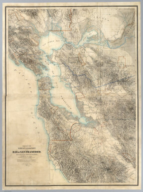
[Hoffmann, Charles F., Whitney, J.D., Geological Survey of California]
Full Title
Map Of The Region Adjacent To The Bay Of San Francisco. State Geological Survey Of California, J.D. Whitney, State Geologist. W. H. Brewer, W. M. Gabb, and A. Rémond, Assistants. C.F. Hoffman, Topographer. The Coast, Rancho, Township and Section Lines from Materials furnished by the U.S. Coast Survey and the U.S. Surveyor General's Office, the Topography chiefly from Original Surveys by C.F. Hoffman ... 1867. Engraved by Julius Bien, N.Y.
Publisher
Julius Bien
Author
Warren, Gouverneur Kemble, 1830-1882
Full Title
Map Of The Territory Of The United States From The Mississippi River To The Pacific Ocean; Originally prepared to accompany the Reports of the Explorations For A Pacific Railroad Route ... Compiled from authorized explorations and other reliable data by Lieut. G.K. Warren, Top'l. Eng'rs. In the Office of Pacific R.R. Surveys, War Dept. under the direction of Bvt. Maj. W.H. Emory, Top'l. Eng'rs. in 1854. Capt. A.A. Humphreys, Top'l. Eng'rs. in 1854-58. And partly recompiled and redrawn under the direction of the Engineer Bureau in 1865-66-67. Engineer Bureau, War Department. Engraved on stone by Julius Bien, New York.
Publisher
Julius Bien
|