Who What Where WhenREMOVEWHATShow MoreWHERE
|
Author
Colton, G.W.
Full Title
Colton's East Indies. (inset) Island and strait of Singapore. Published By G. W & C. B. Colton & Co. No. 172 William St. New York.
Publisher
G. W & C. B. Colton & Co.
Author
Colton, G.W.
Full Title
Colton's Hawaiian Group or Sandwich Islands. New Zealand. Viti Group or Feejee (Fiji) Islands. Tonga or Friendly Is. Samon or Navigators Is. Society Islands. Marquesas or Washington Is. Calapacos Islands. Surveyed by the U. S. Exploring Expedition, 1839-1841. Published By G. W & C. B. Colton & Co. No. 172 William St. New York.
Publisher
G. W & C. B. Colton & Co.
Author
[Johnston, Alexander Keith, 1804-1871, Rogers, Henry Darwin, Stanford, Edward]
Full Title
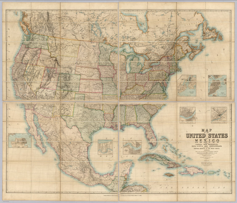
(Covers to) Map Of The United States And Mexico With Canada, New Brunswick, Nova Scotia and Newfoundland, And Parts Of Central America & The West Indies. Constructed From State Documents & Unpublished Materials By Professor H.D. Rogers of Boston U.S. and A. Keith Johnston, F.R.S.E Geographer to the Queen. London; Published by Edward Stanford, 6 Charing Cross, S.W. May 13th. 1861. Additions to 1869.
Publisher
Edward Stanford
Author
[Johnston, Alexander Keith, 1804-1871, Rogers, Henry Darwin, Stanford, Edward]
Full Title
(Covers to) Map Of The United States And Mexico With Canada, New Brunswick, Nova Scotia and Newfoundland, And Parts Of Central America & The West Indies. Constructed From State Documents & Unpublished Materials By Professor H.D. Rogers of Boston U.S. and A. Keith Johnston, F.R.S.E Geographer to the Queen. London; Published by Edward Stanford, 6 Charing Cross, S.W. May 13th. 1861. Additions to 1869.
Publisher
Edward Stanford
Author
[Copley, Charles, Joslin, Gilman]
Full Title
Improved Globe, Boston. Manufactured by Gilman Joslin, Corrected to 1870. Entered according to Act of Congress in the year 1852 by Charles Copley ... New York. (Terrestrial Globe).
Publisher
Gilman Joslin
Author
[Copley, Charles, Joslin, Gilman]
Full Title
Improved Globe, Boston. Manufactured by Gilman Joslin, Corrected to 1870. Entered according to Act of Congress in the year 1852 by Charles Copley ... New York. (Celestial Globe).
Publisher
Gilman Joslin
Author
[Gibbes, C.D., Holt, Warren]
Full Title
Map of the States Of California And Nevada. Carefully Compiled from the Latest Authentic Sources. California By Julius H. Von Schmidt, Arthur W. Keddie, And C.D. Gibbes, C.E.'s. Nevada By Chas. Drayton Gibbes C.E. S.B. Linton Engr. & Lithogr. 148-1/2 S. 4th Street, Philadelphia. Comprising Information obtained from the U.S. Coast And Land Surveys; State Geological Surveys, By Prof. J.D. Whitney; Railroad Surveys And The Results Of Explorations Made By Brevet Lieut. Col. R.S. Williamson, U.S.A., Henry DeGroot, C.D. Gibbes, And Others. Published by Warren Holt. No. 411 Kearny Street, San Francisco, Cal. 1869. Entered ... 1868, by Warren Holt ... California. (with 1 inset).
Publisher
Warren Holt
Author
Wheeler, G.M.
Full Title
Map showing Detailed Topography Of The Country Traversed by the Reconnaissance Expedition through Southern & Southeastern Nevada in charge of Lieut. Geo. M. Wheeler U.S. Engineers. Assisted by Lieut. O.W. Lockwood Corps Of Engineers U.S.A. 1869. P.W. Hamel Chief Topographer And Draughtsman. Photolith. by the N.Y. Lithg. Engrg. & Prtg. Co. 16 & 18 Park Place.
Publisher
U.S.
Author
[California Geological Survey, Whitney, J.D., Gardner, J.T., Hoffmann, Chs. F.]
Full Title
Map of a Portion of the Sierra Nevada adjacent to Yosemite Valley, from surveys made by Chs. F. Hoffmann and J.T. Gardner, 1863 -1867. Geological Survey of California, J.D. Whitney, State Geologist. J. Bien, Lith. N.Y.
Publisher
Julius Bien
Author
[Great Britain. Ordnance Survey, Mudge, William (1762-1820), Colby, Thomas, Baker, Benjamin, Great Britain. Board of Ordnance]
Full Title
101. Cockermouth.
Publisher
[W. Mudge; Ordnance Survey, Thomas Colby (1784-1852)]
Author
[Great Britain. Ordnance Survey, Mudge, William (1762-1820), Colby, Thomas, Baker, Benjamin, Great Britain. Board of Ordnance]
Full Title
104. Whitby.
Publisher
[W. Mudge; Ordnance Survey, Thomas Colby (1784-1852)]
Author
[Great Britain. Ordnance Survey, Mudge, William (1762-1820), Colby, Thomas, Baker, Benjamin, Great Britain. Board of Ordnance]
Full Title
106. Haltwhistle.
Publisher
[W. Mudge; Ordnance Survey, Thomas Colby (1784-1852)]
Author
[Great Britain. Ordnance Survey, Mudge, William (1762-1820), Colby, Thomas, Baker, Benjamin, Great Britain. Board of Ordnance]
Full Title
107. Carlisle.
Publisher
[W. Mudge; Ordnance Survey, Thomas Colby (1784-1852)]
Author
[Great Britain. Ordnance Survey, Mudge, William (1762-1820), Colby, Thomas, Baker, Benjamin, Great Britain. Board of Ordnance]
Full Title
109. Alnwick.
Publisher
[W. Mudge; Ordnance Survey, Thomas Colby (1784-1852)]
Author
Stieler, Adolf
Full Title
Stieler's Hand-Atlas ... No. 35a. Die Meerenge von Gibraltar. (inset) Gibraltar. Das Spanische Gebiet von Ceute.
Publisher
Justus Perthes
Author
[Stieler, Adolf, Petermann, A.]
Full Title
Stieler's Hand-Atlas ... No. 38b. Die Europaeische Turkei. (inset) Der Bosphorus, Constantinopel.
Publisher
Justus Perthes
Author
Stieler, Adolf
Full Title
Stieler's Hand-Atlas ... No. 41b. Polar-Karte.
Publisher
Justus Perthes
Author
[Stieler, Adolf, Petermann, A.]
Full Title
Stieler's Hand-Atlas ... No. 42a. Sud-Polar-Karte.
Publisher
Justus Perthes
Author
[Berghaus, Hermann, Stieler, Adolf]
Full Title
Stieler's Hand-Atlas ... No. 48. West-Indien und Central-Amerika. (insets) Isthmus von Nicaragua. Isthmus von Panama.
Publisher
Justus Perthes
Author
Stieler, Adolf
Full Title
Stieler's Hand-Atlas ... No. 4. Planeten_System der Sonne.
Publisher
Justus Perthes
Author
[Colton, G.W., Colton, C.B., Gray, O.W.]
Full Title
Missouri. Entered ... 1869 by G.W. & C.B. Colton & Co.
Publisher
Stedman & Brown
Author
[Alaskan Boundary Tribunal, U.S. Coast Survey]
Full Title
(Facsimile) Tracing of part of "Alaska" shewing "Stakeen (Stickeen) River" from U.S. Coast Survey of 1869. Certified, Domn. Lands Office, Jan. 16th. 1878. The Burland Desbarats Lith. Co. Montreal.
Publisher
(U.S.) Government Printing Office
Author
[Alaskan Boundary Tribunal, Imray, James]
Full Title
(Facsimile) North Pacific (portion), London Published by James Imray and Son, 89 Minories and Tower Hill, 1869. Alaskan Boundary Tribunal, 1903. 33. Andrew B. Graham. Photo-Litho. Washington.D.C.
Publisher
Government Printing Office
|