Browse All

1870 Text page: Map And Street Directory Of S … Guide Book (Text page) Map Of San Francisco From th … |

1870 Text page: Map And Street Directory Of S … Guide Book (Text page) Map Of San Francisco From th … |

1870 Text page: Map And Street Directory Of S … Guide Book (Text page) Map Of San Francisco From th … |

1870 Text page: Map And Street Directory Of S … Guide Book (Text page) Map Of San Francisco From th … |

1870 Text page: Map And Street Directory Of S … Guide Book (Text page) Map Of San Francisco From th … |

1870 Text page: Map And Street Directory Of S … Guide Book (Text page) Map Of San Francisco From th … |

1870 Covers: Pacific Rail Road Route Pocket Map (Covers to) Map Of The Pacific Rail Road … |

1870 Pacific Rail Road Route Pocket Map Map Of The Pacific Rail Road Route From … |

1870 Covers: Atlas Accompanying Volume III on … Geologic Atlas (Cover to) Atlas Accompanying Volume III … |

1870 Title Page: U.S. Geological Exploration … Geologic Atlas (Title Page) United States Geological Ex … |

1870 Plate 1. Part of the U.S. Engineer Depar … Geologic Atlas Plate 1. Part of the U.S. Engineer Depar … |

1870 Plate 2. Geological Map of the Washoe Mi … Geologic Atlas Plate 2. Geological Map of the Washoe Mi … |

1870 Plate 3. Horizontal Map Gold Hill Mines … Geologic Atlas Plate 3. Horizontal Map Gold Hill Mines … |

1870 Plate 4. Horizontal Map Virginia Mines W … Geologic Atlas Plate 4. Horizontal Map Virginia Mines W … |

1870 Plate 6. Longitudinal Elevation Gold Hil … Geologic Atlas Plate 6. Longitudinal Elevation Gold Hil … |

1870 Plate 7. Longitudinal Elevation Virginia … Geologic Atlas Plate 7. Longitudinal Elevation Virginia … |

1870 Plate 8. Cross Sections Gold Hill Mines, … Geologic Atlas Plate 8. Cross Sections Gold Hill Mines, … |

1870 Plate 11. Cross Sections Virginia Mines, … Geologic Atlas Plate 11. Cross Sections Virginia Mines, … |

1870 Plate 12. Sections, Comstock Lode. Geologic Atlas Plate 12. Sections, Comstock Lode. |
1870 Plate 13. Geological Map of the Toyabe ( … Geologic Atlas Plate 13. Geological Map of the Toyabe ( … |

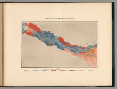
1870 Plate 14. Geological Map of the White Pi … Geologic Atlas Plate 14. Geological Map of the White Pi … |

1870 Plate 5. Horizontal Map North Virginia M … Geologic Atlas Plate 5. Horizontal Map North Virginia M … |

1870 Plate 9. Cross Sections Virginia Mines, … Geologic Atlas Plate 9. Cross Sections Virginia Mines, … |

1870 Plate 10. Cross Sections Virginia Mines, … Geologic Atlas Plate 10. Cross Sections Virginia Mines, … |

1870 Covers: Nebraska Pocket Map (Covers to) Colton's New Sectional Map O … |

1870 Nebraska Pocket Map Colton's New Sectional Map Of The State … |

1870 Covers: Missouri Pocket Map (Covers to) Colton's New Map of Missouri … |

1870 Missouri Pocket Map Colton's New Map of Missouri Compiled fr … |

1870 Covers: Canada Pocket Map (Covers to) New Map Of The Dominion Of C … |

1870 Canada Pocket Map New Map Of The Dominion Of Canada. Dawso … |

1870 Covers: Railroad & Commercial Atlas Of T … Pocket Map (Covers to) Colton's Railroad & Commerci … |

1870 Railroad & Commercial Atlas Of The Unite … Pocket Map Colton's Railroad & Commercial Atlas Of … |

1870 Cover: New general atlas. [State Atlas, World Atlas] (Covers to) Mitchell's new general atlas … |

1870 Title Page: New general atlas. [State Atlas, World Atlas] (Title Page to) Mitchell's new general a … |

1870 Contents Page: New general atlas. [State Atlas, World Atlas] (Contents to) Mitchell's new general atl … |

1870 World hemispheres. [State Atlas, World Atlas] The World in hemispheres. With other pro … |

1870 Time table. [State Atlas, World Atlas] A time table indicating the difference i … |

1870 World Mercator proj. [State Atlas, World Atlas] Map of the World on the Mercator project … |

1870 North America. [State Atlas, World Atlas] Map of North America. Showing its politi … |

1870 Nova Scotia, New Brunswick, P.E.I. [State Atlas, World Atlas] County map of Nova Scotia, New Brunswick … |

1870 Quebec. [State Atlas, World Atlas] Map of Quebec in counties. (with) Enviro … |

1870 Ontario. [State Atlas, World Atlas] Map of Ontario in counties. Entered ... … |

1870 United States. [State Atlas, World Atlas] Map of the United States and territories … |

1870 Maine. [State Atlas, World Atlas] County map of the state of Maine. (with) … |

1870 N.H., Vermont. [State Atlas, World Atlas] New Hampshire and Vermont. Drawn & engd. … |

1870 Mass., Conn., R.I. [State Atlas, World Atlas] County map of Massachusetts, Connecticut … |

1870 Boston. [State Atlas, World Atlas] Plan of Boston. (with) Map of the countr … |

1870 New York (State) [State Atlas, World Atlas] County map of the state of New York. (wi … |

1870 New York, Brooklyn. [State Atlas, World Atlas] New York and Brooklyn. Entered ... 1870 … |

1870 Pennsylvania. [State Atlas, World Atlas] County map of the state of Pennsylvania. … |