Browse All

1873 Hoboken - Plate E. [County Atlas, State Atlas] Hoboken - Plate E. |

1873 Southern Part of West Hoboken - Plate A. [County Atlas, State Atlas] Southern Part of West Hoboken - Plate A. |
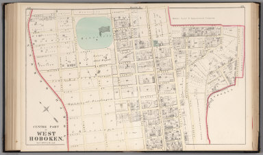
1873 Centre Part of West Hoboken - Plate B. [County Atlas, State Atlas] Centre Part of West Hoboken - Plate B. |

1873 West Hoboken - Plate C. [County Atlas, State Atlas] West Hoboken - Plate C. |

1873 Northern Part of the Town of Union - Pla … [County Atlas, State Atlas] Northern Part of the Town of Union - Pla … |

1873 Southern Part of the Town of Union. [County Atlas, State Atlas] Southern Part of the Town of Union. |

1873 Northern Part of the Union Township - Pl … [County Atlas, State Atlas] Northern Part of the Union Township - Pl … |

1873 Southern Part of the Town of Union - Pla … [County Atlas, State Atlas] Southern Part of the Town of Union - Pla … |

1873 Plan of Weehawken Township. [County Atlas, State Atlas] Plan of Weehawken Township. |

1873 North Bergen Township. [County Atlas, State Atlas] North Bergen Township. |

1873 Part of Plan of North Bergen Township. [County Atlas, State Atlas] Part of Plan of North Bergen Township. |

1873 Part of North Bergen Township. [County Atlas, State Atlas] Part of North Bergen Township. |

1873 Part of Kearney Township. [County Atlas, State Atlas] Part of Kearney Township. |

1873 Part of Harrison East Newark - Plate A. [County Atlas, State Atlas] Part of Harrison East Newark - Plate A. |

1873 Part of Harrison, East Newark - Plate B. [County Atlas, State Atlas] Part of Harrison, East Newark - Plate B. |

1873 Formerly Greenville, now Part of Sixth D … [County Atlas, State Atlas] Formerly Greenville, now Part of Sixth D … |

1873 City of Bayonne. [County Atlas, State Atlas] City of Bayonne. |

1873 Cover: Atlas W. Virginia. State Atlas (Covers to) White's new county and distr … |

1873 Title Page: Atlas W. Virginia. State Atlas (Title Page to) White's new county and d … |

1873 Contents: Atlas W. Virginia. State Atlas (Contents Page to) White's new county an … |

1873 Time table. State Atlas A time table indicating the difference i … |

1873 World. State Atlas Map of the World on the Mercator project … |

1873 U.S., Canada. State Atlas Map of the United States, and territorie … |

1873 County map W. Va. State Atlas County map of West Virginia. Drawn & eng … |

1873 Political W. Va. State Atlas White's political map of West Virginia. … |

1873 Coal fields W. Va. State Atlas Map showing the coal fields of West Virg … |

1873 Morgan, Berkeley, Jefferson counties. State Atlas White's topographical, county & district … |

1873 Mineral, Hampshire counties. State Atlas White's topographical, county & district … |

1873 Grant, Hardy counties. State Atlas White's topographical, county & district … |

1873 Randolph, Pendleton counties. State Atlas White's topographical, county & district … |

1873 Preston, Taylor, Barbour, Tucker countie … State Atlas White's topographical, county & district … |

1873 Wetzel, Monongalia, Marion, Doddridge, H … State Atlas White's topographical, county & district … |

1873 Winfield. State Atlas Plan of Winfield, Putnam County. (with) … |

1873 Mannington, W. Va. State Atlas Plan of Mannington, Marion County, W. Va … |

1873 Hancock, Brooke, Ohio, Marshall counties … State Atlas White's topographical, county & district … |

1873 Wheeling. State Atlas Wheeling. (with) New Manchester. (with) … |

1873 Tyler, Ritchie, Pleasants, Wood, Wirt co … State Atlas White's topographical, county & district … |

1873 Parkersburg. State Atlas Parkersburg. Entered according to Act of … |

1873 Mason, Jackson, Roane counties. State Atlas White's topographical, county & district … |

1873 Calhoun, Gilmer, Braxton, Lewis, Upshur … State Atlas White's topographical, county & district … |

1873 Pocohontas, Greenbrier counties. State Atlas White's topographical, county & district … |

1873 Clay, Webster, Nicholas, Fayette countie … State Atlas White's topographical, county & district … |

1873 Charleston. State Atlas City of Charleston, Capitol of West Virg … |

1873 Putnam, Kanawha, Boone counties. State Atlas White's topographical, county & district … |

1873 Huntington. State Atlas City of Huntington. (with) Clarksburg. ( … |

1873 Cabell, Wayne, Lincoln, Logan counties. State Atlas White's topographical, county & district … |

1873 Pt. Pleasant. State Atlas Plan of Pt. Pleasant, Mason County, W. V … |

1873 Raleigh, Mercer, Summers, Monroe countie … State Atlas White's topographical, county & district … |

1873 Wyoming, McDowell counties. State Atlas White's topographical, county & district … |

1873 Palestine. State Atlas A new map of Palestine or the Holy Land. … |