Who What Where WhenREMOVEWHATShow MoreWHEREShow More |
Author
Martin de Moussy, V. (Victor), 1810-1869
Full Title
Carte physique de la Confederation Argentine pour faire suite aux travaux de Mr. V. Martin de Moussy, 1869. Grave par L. Kautz, r. Bonaparte 82, Paris. Paris, Imp. Lemercier et Cie., r. de Seine 57. (Paris Librairie de Firmin Didot Freres, Fils et Cie., 1873)
Publisher
Firmin Didot Freres.
Author
[Martin de Moussy, V. (Victor), 1810-1869, Sourdeaux, A.]
Full Title
Coupes geologiques diverses. Grave par L. Kautz, r. Bonaparte 82, Paris. Paris, Imp. Lemercier, r. de Seine 57. (Paris Librairie de Firmin Didot Freres, Fils et Cie., 1873)
Publisher
Firmin Didot Freres.
Author
Martin de Moussy, V. (Victor), 1810-1869
Full Title
Coupes geologiques diverses - altitudes. Grave par Kautz, r. Bonaparte 82 - Paris. Paris - Imp. Lemercier, r. de Seine 57. (Paris Librairie de Firmin Didot Freres, Fils et Cie., 1873)
Publisher
Firmin Didot Freres.
Author
Martin de Moussy, V. (Victor), 1810-1869
Full Title
Coupes orographiques des parties centrales du territoire Argentin, de 260 a 330 L.S. Grave par Kautz, r. Bonaparte 82 - Paris. Paris - Imp. Lemercier, r. de Seine 57. (Paris Librairie de Firmin Didot Freres, Fils et Cie., 1873)
Publisher
Firmin Didot Freres.
Author
Martin de Moussy, V. (Victor), 1810-1869
Full Title
No. 1. Coupes du continent Sud Americain entre les Oceans Atlantique et Pacifique en moyenne sous le 33eme. de latitude en passant par l'extremite Sud du Massif central Argentin et la Cordillere de Mendoza. No. 2. Coupe sous le 40eme. parallele entre Valdivia et le Carmen pres l'embouchure du Rio Negro. No. 3. Coupe sous le 41eme. entre le Port Montt et le Carmen par le Lac de Nahuel-Huapi et le Rio Negro. Grave par Kautz, r. Bonaparte 82 - Paris. Paris - Imp. Lemercier, r. de Seine 57. (Paris Librairie de Firmin Didot Freres, Fils et Cie., 1873)
Publisher
Firmin Didot Freres.
Author
Martin de Moussy, V. (Victor), 1810-1869
Full Title
Coupe de la route de Buenos-Ayres a Lima par les Pampas et les Andes. Grave par L. Kautz, r. Bonaparte 82 - Paris. Paris, Imp. Lemercier, r. de Seine 57. (Paris Librairie de Firmin Didot Freres, Fils et Cie., 1873)
Publisher
Firmin Didot Freres.
Author
Martin de Moussy, V. (Victor), 1810-1869
Full Title
Coupe de divers passages de la Cordillere des Andes. Grave par Kautz, r. Bonaparte 82 - Paris. Paris - Imp. Lemercier, r. de Seine 57. (Paris Librairie de Firmin Didot Freres, Fils et Cie., 1873)
Publisher
Firmin Didot Freres.
Author
Martin de Moussy, V. (Victor), 1810-1869
Full Title
Carte du cours du Haut Uruguay depuis la Concepcion jusqu'aux frontieres Argentine et Bresilienne dans le Territoire extreme des Missions. 1ere. feuille. De la Ville de la Concepcion a celle de la Uruguayana. Par le Dr. V. Martin de Moussy, 1866. Grave par L. Kautz, r. Bonaparte 82 - Paris. Paris - Imp. Lemercier, r. de Seine 57. (Paris Librairie de Firmin Didot Freres, Fils et Cie., 1873)
Publisher
Firmin Didot Freres.
Author
Martin de Moussy, V. (Victor), 1810-1869
Full Title
Carte du cours du Haut Uruguay depuis la Concepcion jusqu'aux frontieres Argentine et Bresilienne dans le Territoire extreme des Missions. 2eme. feuille. De la Ville de la Uruguayana au Rio Pepiri-Guazu. Par le Dr. V. Martin de Moussy, 1866. Grave par Kautz, r. Bonaparte 82 - Paris. Paris - Imp. Lemercier, r. de Seine 57. (Paris Librairie de Firmin Didot Freres, Fils et Cie., 1873)
Publisher
Firmin Didot Freres.
Author
[Martin de Moussy, V. (Victor), 1810-1869, Page, Thomas Jefferson, 1808-1899]
Full Title
Cours inferieur et bouches du Rio Paraguay d'apres les reconnaissances du Commandant Thomas Page en 1853. Chutes du Rio Parana dites de Maracayu ou las Siete Caidas. Bouche et chutes de l'Y-Guazu. Grave par Kautz, r. Bonaparte 82, Paris. Paris. Imp. Lemercier, r. de Seine 57. (Paris Librairie de Firmin Didot Freres, Fils et Cie., 1873)
Publisher
Firmin Didot Freres.
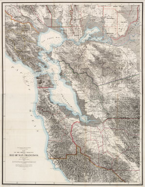
Author
[Hoffmann, Charles F., Whitney, J.D., Geological Survey of California]
Full Title
(North Sheet) State Geological Survey Of California. J.D. Whitney, State Geologist. Map Of The Region Adjacent To The Bay Of San Francisco. 1873. The Coast, Rancho, Township and Section Lines from Materials furnished by the U.S. Coast Survey and the U.S. Surveyor General's Office, the Topography chiefly from Original Surveys by C.F. Hoffman ... Julius Bien, Lith.
Publisher
Julius Bien
Author
[Hoffmann, Charles F., Whitney, J.D., Geological Survey of California]
Full Title
(South Sheet) State Geological Survey Of California. J.D. Whitney, State Geologist. Map Of The Region Adjacent To The Bay Of San Francisco. 1873. The Coast, Rancho, Township and Section Lines from Materials furnished by the U.S. Coast Survey and the U.S. Surveyor General's Office, the Topography chiefly from Original Surveys by C.F. Hoffman ... Julius Bien, Lith.
Publisher
Julius Bien
Author
[Hoffmann, Charles F., Whitney, J.D., Geological Survey of California]
Full Title
(Covers to) State Geological Survey Of California. J.D. Whitney, State Geologist. Map Of The Region Adjacent To The Bay Of San Francisco. 1873. The Coast, Rancho, Township and Section Lines from Materials furnished by the U.S. Coast Survey and the U.S. Surveyor General's Office, the Topography chiefly from Original Surveys by C.F. Hoffman ... Julius Bien, Lith.
Publisher
Julius Bien
Author
[Hoffmann, Charles F., Whitney, J.D., Geological Survey of California]
Full Title
(Composite) State Geological Survey Of California. J.D. Whitney, State Geologist. Map Of The Region Adjacent To The Bay Of San Francisco. 1873. The Coast, Rancho, Township and Section Lines from Materials furnished by the U.S. Coast Survey and the U.S. Surveyor General's Office, the Topography chiefly from Original Surveys by C.F. Hoffman ... Julius Bien, Lith.
Publisher
Julius Bien
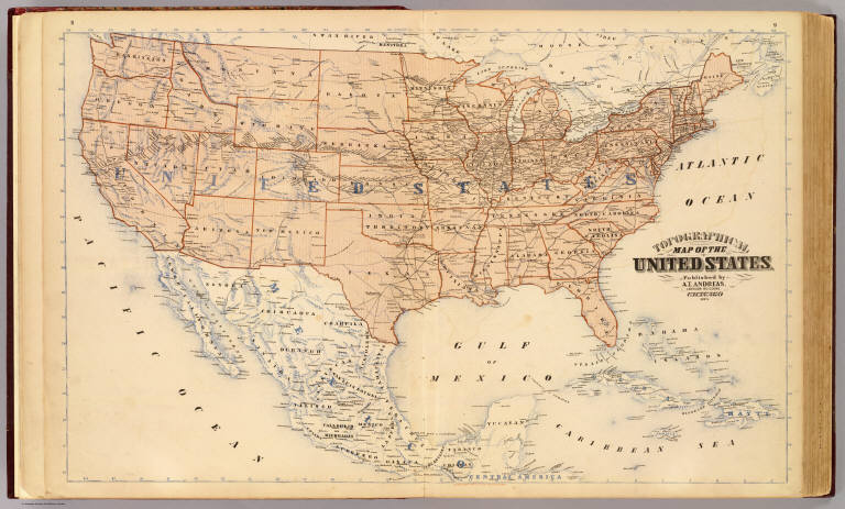
Author
Andreas, A. T. (Alfred Theodore), 1839-1900
Full Title
Topographical map of the United States. Published by A.T. Andreas, Lakeside Building, Chicago, 1873. (Chas. Shober & Co. Proprietors of Chicago Lith. Co.)
Publisher
A.T. Andreas
Author
[Beers, J.B. & Co., H.W. Burgett and Company]
Full Title
City of Burlington, Chittenden Co., Vt., 1873. (Published by H.W. Burgett & Co. 36 Vesey Street, New-York. 1876. Entered ... 1876 by H.W. Burgett & Co. ... Washington D.C. Engraved & printed by J.B. Beers & Co. 36 Vesey St. N.Y.)
Publisher
H.W. Burgett & Co.
Author
Wheeler, G.M.
Full Title
Southwestern Utah. Atlas Sheet Number 59. Construction by Chas. Herman. Topographical drawing by J.E. Weyss. Lettering by A.A. Aguirre. Expeditions of 1859, 1872 & 1873. 1st. Lieut. Geo. M. Wheeler, Corps of Engineers, Com'd'g. Explorations & Surveys West Of The One-Hundredth Meridian. War Department, Corps of Engineers, U.S. Army.
Publisher
U.S.
Author
Wheeler, G.M.
Full Title
Southwestern Utah. Atlas Sheet Number 59. Weyss, Herman & Aguirre, Del. Expeditions of 1872 & 1873 Under the Command of 1st. Lieut. Geo. M. Wheeler, Corps of Engineers, U.S. Army. Explorations & Surveys West Of The One-Hundredth Meridian.
Publisher
U.S.
Author
Wheeler, G.M.
Full Title
Southern And Southwestern Utah. Atlas Sheet Number 59. Weyss, Herman & Aguirre, Del's. Expeditions of 1872 & 1873 Under the Command of 1st. Lieut. Geo. M. Wheeler, Corps of Engineers, U.S. Army. Geological Assistants: G.K. Gilbert, A.R. Marvine, E.E. Howell. Explorations & Surveys West Of The One-Hundredth Meridian.
Publisher
U.S.
Author
Wheeler, G.M.
Full Title
Atlas Sheet Number 58. Parts Of E. California, S.E. Nevada, N.W. Arizona & S.W. Utah. Atlas Sheet Number 66. Weyss, Herman & Aguirre, Del. Expeditions of 1872 & 1873, Under the Command of 1st. Lieut. Geo. M. Wheeler, Corps of Engineers, U.S. Army. Geological Assistants: G.K. Gilbert, A.R. Marvine and E.E. Howell. U.S. Geographical Surveys West Of The One-Hundredth Meridian.
Publisher
U.S.
Author
Wheeler, G.M.
Full Title
Central & Western Utah Atlas Sheet Number 50. Expeditions of 1872 & 1873. 1st Lieut. Geo. M. Wheeler, Corps of Engineers, Com'd'g. Explorations & Surveys West Of The One Hundredth Meridian. War Department, Corps of Engineers, U.S. Army.
Publisher
U.S.
Author
Wheeler, G.M.
Full Title
Central & Western Utah Atlas Sheet Number 50. Weyss, Herman & Aguirre Del. Expeditions of 1872 & 1873, Under the Command of 1st Lieut. Geo. M. Wheeler, Corps of Engineers, U.S. Army. Explorations & Surveys West Of The One Hundredth Meridian.
Publisher
U.S.
Author
Wheeler, G.M.
Full Title
Central & Western Utah Atlas Sheet Number 50. Weyss, Herman & Aguirre Del. Expeditions of 1872 & 1873, Under the Command of 1st Lieut. Geo. M. Wheeler, Corps of Engineers, U.S. Army. U.S. Geographical Surveys West Of The One Hundredth Meridian.
Publisher
U.S.
Author
[Geological Survey of Great Britain and Ireland, Great Britain, Ordnance Survey Office]
Full Title
90. Southport, SE Quad.
Publisher
Ordnance Map Office
Author
Wheeler, G.M.
Full Title
(Title Page to) Topographical Atlas Projected To Illustrate United States Geographical Surveys West Of The 100th Meridian Of Longitude Prosecuted In Accordance With Acts Of Congress Under The Authority Of The Honorable The Secretary Of War, And The Direction Of Brig. Genl. A.A. Humphreys, Chief Of Engineers, U.S. Army. Embracing Results Of the Different Expeditions Under The Command Of 1st Lieut. Geo. M. Wheeler, Corps Of Engineers. Julius Bien, lith.
Publisher
U.S.
Author
Wheeler, G.M.
Full Title
(Title Page to) Geological Atlas Projected To Illustrate Geographical Explorations And Surveys West Of The 100th Meridian Of Longitude Prosecuted In Accordance With Acts Of Congress Under The Authority Of The Honorable The Secretary Of War, And The Direction Of Brig. Genl. A.A. Humphreys, Chief Of Engineers, U.S. Army. Embracing Results Of the Different Expeditions Under The Command Of 1st Lieut. Geo. M. Wheeler, Corps Of Engineers. Julius Bien, lith.
Publisher
U.S.
Author
Wheeler, G.M.
Full Title
Map Of The Areas Of Drainage To The Atlantic And Pacific Oceans And Of The Interior Basins Of The Territory Of The United States West of the Mississippi River. Louis Nell del. West Of The One Hundredth Meridian. Seasons of 1869, 1871, 1872 and 1873. 1st Lieut. Geo. M. Wheeler, Corps of Engineers, in charge. Geographical & Geological Explorations & Surveys. War Department Corps Of Engineers. U.S. Army.
Publisher
U.S.
Author
Wheeler, G.M.
Full Title
(Cover to) War Department Corps of Engineers. U.S. Army. U.S. Geographical Surveys West Of The One-Hundredth Meridian. Topographical Atlas. Wheeler. 1878.
Publisher
U.S.
Author
Wheeler, G.M.
Full Title
(Cover to) Geographical Explorations And Surveys West Of The 100th Meridian. Geological Atlas. Wheeler. 1874.
Publisher
U.S.
Author
Wheeler, G.M.
Full Title
Legend. West Of the One-Hundredth Meridian. Seasons of 1869, 1871, 1872, & 1873. 1st. Lieut. Geo. M. Wheeler, Corps of Engineers, U.S. Army in Charge. Geographical Explorations & Surveys.
Publisher
U.S.
Author
Wheeler, G.M.
Full Title
Skeleton Map Of the Territory of the United States west of the Mississippi River Exhibiting the Relations Existing Between Lines And Areas Of Explorations & Surveys Conducted under the auspices of the War Dept. Giving the area of the public domain lying west of the 100th Meridian Of Longitude With an index illustration of a series of Atlas Maps. Proposed to be constructed on a scale of 1 inch to 8 m. Engineer Department U.S. Army. U.S: Engineer Office, Washington D.C. Louis Nell Del. Am. Photo-lithographic Co. N.Y. (Osborne's Process) Prepared to accompany the "Preliminary & Progress Report" concerning the "Expedition of 1872 & 1873." Explorations And Surveys West Of The One-Hundredth Meridian.
Publisher
U.S.
Author
Wheeler, G.M.
Full Title
Conventional Signs. West Of The One-Hundredth Meridian. Seasons of 1869, 1871, 1872, 1873 & 1874. 1st. Lieut. Geo. M. Wheeler, Corps of Engineers, U.S. Army in Charge. Geographical Explorations & Surveys.
Publisher
U.S.
Author
Wheeler, G.M.
Full Title
Conventional Signs For Triangulation Outline And Topographical Plots Of Atlas Sheets. West Of The 100th Meridian. Expeditions - Under the Command of 1st. Lieut. Geo. M. Wheeler, Corps of Engineers, U.S. Army. U.S. Geographical Surveys.
Publisher
U.S.
Author
Wheeler, G.M.
Full Title
Progress Map Of Lines And Areas Of Explorations And Surveys Conducted Under The Auspices Of The War Department Giving The Area Of The Public Domain Lying West Of The 100th Meridian Of Longitude With An Index Illustration Of A Series Of Atlas Maps Prepared Under The Direction Of 1st. Lieut. Geo. M. Wheeler. Corps Of Engineers. West Of The One Hundredth Meridian. N. Peters., Photo-Lithographer, Washington, D.C. Seasons of 1869, 1871, 1872 & 1873. 1st. Lieut. Geo. M. Wheeler. Corps Of Engineers, in charge. Geographical & Geological Explorations & Surveys. War Department, Corps Of Engineers, U.S. Army.
Publisher
U.S.
Author
Wheeler, G.M.
Full Title
Progress Map Of Lines And Areas Of Explorations And Surveys Conducted Under The Auspices Of The War Department Giving The Area Of The Public Domain Lying West Of The 100th Meridian Of Longitude With An Index Illustration Of A Series Of Atlas Maps Prepared Under The Direction Of 1st. Lieut. Geo. M. Wheeler. Corps Of Engineers. Louis Nell del. West Of The One Hundredth Meridian. Seasons of 1869, 1871, 1872 & 1873. 1st. Lieut. Geo. M. Wheeler. Corps Of Engineers, in charge. Geographical & Geological Explorations & Surveys. War Department, Corps Of Engineers, U.S. Army.
Publisher
U.S.
Author
[Stieler, Adolf, Petermann, A.]
Full Title
Stieler's Hand-Atlas ... No. 15a. Die Britischen Inseln und das Umliegende Meer. (insets) London. Crystall Palast. Helgoland. Rockall (View).
Publisher
Justus Perthes
Author
[Stieler, Adolf, Petermann, A.]
Full Title
Stieler's Hand-Atlas ... No. 15d. Ireland. (insets) Dublin und Dublin Bay. Die See'n von Killarney.
Publisher
Justus Perthes
Author
[Stieler, Adolf, Petermann, A.]
Full Title
Stieler's Hand-Atlas ... No. 15c. Grossbritannien. (inset) Die Shetland und Orkney Inseln. Edinbugh und Umgebung.
Publisher
Justus Perthes
Author
Stieler, Adolf
Full Title
Stieler's Hand-Atlas ... No. 16a. Schweden und Norwegen, Daenemark, Island u. Faer-oer.
Publisher
Justus Perthes
Author
[Stieler, Adolf, Petermann, A.]
Full Title
Stieler's Hand-Atlas ... No. 16b. Danemark (Denmark) mit Schleswig, Holstein, und Laeenburg. (insets) Island (Iceland). Kopenhagen (Copenhagen). Die Far-oer. Gronland.
Publisher
Justus Perthes
Author
[Stieler, Adolf, Petermann, A.]
Full Title
Stieler's Hand-Atlas ... No. 16b. Daenemark mit Schleswig, Holstein, und Laeenburg. (insets) Island (Iceland). Kopenhagen (Copenhagen). Die Far-oer. Gronland.
Publisher
Justus Perthes
Author
[Stieler, Adolf, Petermann, A.]
Full Title
Stieler's Hand-Atlas ... No. 16/17. Daenemark mit Schleswig, Holstein, und Laeenburg. (insets) Island (Iceland). Kopenhagen (Copenhagen). Die Far-oer. Gronland.
Publisher
Justus Perthes
Author
Stieler, Adolf
Full Title
Stieler's Hand-Atlas ... No. 18. Fluss u. Berg-Karte von Deutschland.
Publisher
Justus Perthes
Author
[Stieler, Adolf, Vogel, C.]
Full Title
Stieler's Hand-Atlas ... No. 20. Nord-Ostliches Deutschland.
Publisher
Justus Perthes
Author
[Stieler, Adolf, Vogel, C.]
Full Title
Stieler's Hand-Atlas ... No. 24. Sud-westliches Deutschland und die Schweiz.
Publisher
Justus Perthes
Author
[Berghaus, Hermann, Stieler, Adolf]
Full Title
Stieler's Hand-Atlas ... No. 25. Sud-Ostliches Deutschland ... Italien.
Publisher
Justus Perthes
Author
Stieler, Adolf
Full Title
No. I. Karte von Deutschland den Konigr. der Niederlande dem Kgr. Belgien, der Schweiz und den angranzenden Landern, bis Paris, Lyon, Turin, Mailand, Venedig, Ofen, Konnigsberg, in XXV Blatt.
Publisher
Justus Perthes
Author
Stieler, Adolf
Full Title
No. II. Karte von Deutschland den Konigr. der Niederlande dem Kgr. Belgien, der Schweiz und den angranzenden Landern, bis Paris, Lyon, Turin, Mailand, Venedig, Ofen, Konnigsberg, in XXV Blatt.
Publisher
Justus Perthes
Author
Stieler, Adolf
Full Title
No. III. Karte von Deutschland den Konigr. der Niederlande dem Kgr. Belgien, der Schweiz und den angranzenden Landern, bis Paris, Lyon, Turin, Mailand, Venedig, Ofen, Konnigsberg, in XXV Blatt.
Publisher
Justus Perthes
Author
Stieler, Adolf
Full Title
No. IV. Karte von Deutschland den Konigr. der Niederlande dem Kgr. Belgien, der Schweiz und den angranzenden Landern, bis Paris, Lyon, Turin, Mailand, Venedig, Ofen, Konnigsberg, in XXV Blatt.
Publisher
Justus Perthes
|