Who What Where WhenREMOVEWHATShow More |
Author
Cram, George Franklin
Full Title
Cram's Rail Road & Township Map of Michigan. Published by Geo. F. Cram. Proprietor of the Western Map Depot. 66, Lake St. Chicago Ills. 1875.
Publisher
Cram Atlas Company
Author
Cram, George Franklin
Full Title
Cram's Rail Road & Township Map of Indiana. Published by Geo. F. Cram. Proprietor of the Western Map Depot. 66, Lake St. Chicago Ills. 1875.
Publisher
Cram Atlas Company
Author
Cram, George Franklin
Full Title
Cram's Rail Road & Township Map of Iowa. Published by Geo. F. Cram. Proprietor of the Western Map Depot. 66, Lake St. Chicago Ills. 1875.
Publisher
Cram Atlas Company
Author
Cram, George Franklin
Full Title
Cram's Rail Road & Township Map of Missouri. Published by Geo. F. Cram. Proprietor of the Western Map Depot. 66, Lake St. Chicago Ills. 1875.
Publisher
Cram Atlas Company
Author
Cram, George Franklin
Full Title
Cram's Rail Road & Township Map of Illinois. Published by Geo. F. Cram. Proprietor of the Western Map Depot. 66, Lake St. Chicago Ills. 1875.
Publisher
Cram Atlas Company
Author
Cram, George Franklin
Full Title
Cram's Rail Road & Township Map of Wisconsin. Published by Geo. F. Cram. Proprietor of the Western Map Depot. 66, Lake St. Chicago Ills. 1875.
Publisher
Cram Atlas Company
Author
Cram, George Franklin
Full Title
Cram's Rail Road & Township Map of Indian. Ty. Published by Geo. F. Cram. Proprietor of the Western Map Depot. 66, Lake St. Chicago Ills. 1875.
Publisher
Cram Atlas Company
Author
Cram, George Franklin
Full Title
Cram's Rail Road & Township Map of New Mexico. Published by Geo. F. Cram. Proprietor of the Western Map Depot. 66, Lake St. Chicago Ills. 1875.
Publisher
Cram Atlas Company
Author
Cram, George Franklin
Full Title
Cram's Rail Road & Township Map of Arizona. Published by Geo. F. Cram. Proprietor of the Western Map Depot. 66, Lake St. Chicago Ills. 1875.
Publisher
Cram Atlas Company
Author
Cram, George Franklin
Full Title
Cram's Rail Road & Township Map of Colorado. Published by Geo. F. Cram. Proprietor of the Western Map Depot. 66, Lake St. Chicago Ills. 1875.
Publisher
Cram Atlas Company
Author
Cram, George Franklin
Full Title
Cram's Rail Road & Township Map of Nevada. Published by Geo. F. Cram. Proprietor of the Western Map Depot. 66, Lake St. Chicago Ills. 1875.
Publisher
Cram Atlas Company
Author
Cram, George Franklin
Full Title
Cram's Rail Road & Township Map of California. Published by Geo. F. Cram. Proprietor of the Western Map Depot. 66, Lake St. Chicago Ills. 1875.
Publisher
Cram Atlas Company
Author
Cram, George Franklin
Full Title
Cram's Rail Road & Township Map of Wyoming. Published by Geo. F. Cram. Proprietor of the Western Map Depot. 66, Lake St. Chicago Ills. 1875.
Publisher
Cram Atlas Company
Author
Cram, George Franklin
Full Title
Cram's Rail Road & Township Map of Utah. Published by Geo. F. Cram. Proprietor of the Western Map Depot. 66, Lake St. Chicago Ills. 1875.
Publisher
Cram Atlas Company
Author
Cram, George Franklin
Full Title
Cram's Rail Road & Township Map of Montana. Published by Geo. F. Cram. Proprietor of the Western Map Depot. 66, Lake St. Chicago Ills. 1875.
Publisher
Cram Atlas Company
Author
Cram, George Franklin
Full Title
Cram's Rail Road & Township Map of Washington. Published by Geo. F. Cram. Proprietor of the Western Map Depot. 66, Lake St. Chicago Ills. 1875.
Publisher
Cram Atlas Company
Author
Cram, George Franklin
Full Title
Cram's Rail Road & Township Map of Oregon. Published by Geo. F. Cram. Proprietor of the Western Map Depot. 66, Lake St. Chicago Ills. 1875.
Publisher
Cram Atlas Company
Author
Cram, George Franklin
Full Title
New Railroad Map of the United States & Territories. Published by The Cram Atlas Co. Rand McNally & Co., Printers and Engravers, 79 and 81 Madison St., Chicago.
Publisher
Cram Atlas Company
Author
Rockwell, George
Full Title
(Covers to) Map of part of the Thousand Islands Of The St. Lawrence River Near Alexandria Bay, N.Y. Corrected from an old Canada Map of 1815-16. (Names as known in 1874-5). Entered ... 1875 by Geo. Rockwell ... Washington. U.S.
Publisher
No Publisher
Author
Rockwell, George
Full Title
Map of part of the Thousand Islands Of The St. Lawrence River Near Alexandria Bay, N.Y. Corrected from an old Canada Map of 1815-16. (Names as known in 1874-5). Entered ... 1875 by Geo. Rockwell ... Washington. U.S.
Publisher
No Publisher
Author
Debray, V.
Full Title
(Covers to) Plano General De La Ciudad De Mexico 1875. Litoa. de V. Debray, Editor.
Publisher
Debray, Editor
Author
Debray, V.
Full Title
Plano General De La Ciudad De Mexico 1875. Litoa. de V. Debray, Editor.
Publisher
Debray, Editor
Author
[Gibbes, C.D., Holt, Warren]
Full Title
(Covers to) Map of the States Of California And Nevada. Carefully Compiled from the Latest Authentic Sources. By Chas. Drayton Gibbes, C.E. Comprising Information obtained from the U.S. Coast And Land Surveys ... And Others. Published by Warren Holt. No. 624 Montgomery St., San Francisco, Cal. 1875. Entered ... 1875 by Warren Holt ... Washington. S. Blinton Formerly of the U.S. Coast Survey Draughtsman & Lithographer. 148-1/2 S. Fourth Street, Philadelphia, Pa.
Publisher
Warren Holt
Author
[Gibbes, C.D., Holt, Warren]
Full Title
Map of the States Of California And Nevada. Carefully Compiled from the Latest Authentic Sources. By Chas. Drayton Gibbes, C.E. Comprising Information obtained from the U.S. Coast And Land Surveys ... And Others. Published by Warren Holt. No. 624 Montgomery St., San Francisco, Cal. 1875. Entered ... 1875 by Warren Holt ... Washington. S. Blinton Formerly of the U.S. Coast Survey Draughtsman & Lithographer. 148-1/2 S. Fourth Street, Philadelphia, Pa.
Publisher
Warren Holt
Author
Thayer, H.L.
Full Title
(Covers to) Thayer's Map of Colorado. Published by H.L. Thayer & Co. Denver, Colorado. 1875. Sixth Edition. Entered ... 1875 by H.L. Thayer & Co. ... Washington. Rufus Blanchard Engraver. H.L. Thayer Draftsman.
Publisher
H.L. Thayer
Author
Thayer, H.L.
Full Title
Thayer's Map of Colorado. Published by H.L. Thayer & Co. Denver, Colorado. 1875. Sixth Edition. Entered ... 1875 by H.L. Thayer & Co. ... Washington. Rufus Blanchard Engraver. H.L. Thayer Draftsman.
Publisher
H.L. Thayer
Author
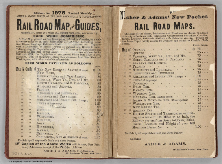
Asher & Adams
Full Title
(Covers to) Asher & Adams' New Commercial And Topographical Rail-Road Map And Guide Of North Carolina And South Carolina. Comprising A New Map, Colored By Counties, On A Scale Of Twenty Miles To An Inch; Delineating Rivers, Landings, Railroads, Stations with Distances, Etc. ... New York: American Rail Road Map And Guide Publishing Company, 39 Beekman Street. Entered... in the year one thousand eight hundred and seventy-four, by Asher & Adams ... Washington. (with map) Asher & Adams' North Carolina And South Carolina. Entered ... 1874 by Asher & Adams ... Washington.
Publisher
American Rail Road Map And Guide Publishing Company
Author
Asher & Adams
Full Title
Asher & Adams' New Commercial And Topographical Rail-Road Map And Guide Of North Carolina And South Carolina. Comprising A New Map, Colored By Counties, On A Scale Of Twenty Miles To An Inch; Delineating Rivers, Landings, Railroads, Stations with Distances, Etc. ... New York: American Rail Road Map And Guide Publishing Company, 39 Beekman Street. Entered... in the year one thousand eight hundred and seventy-four, by Asher & Adams ... Washington. (with map) Asher & Adams' North Carolina And South Carolina. Entered ... 1874 by Asher & Adams ... Washington.
Publisher
American Rail Road Map And Guide Publishing Company
Author
Asher & Adams
Full Title
(Text page to) Asher & Adams' New Commercial And Topographical Rail-Road Map And Guide Of North Carolina And South Carolina. Comprising A New Map, Colored By Counties, On A Scale Of Twenty Miles To An Inch; Delineating Rivers, Landings, Railroads, Stations with Distances, Etc. ... New York: American Rail Road Map And Guide Publishing Company, 39 Beekman Street. Entered... in the year one thousand eight hundred and seventy-four, by Asher & Adams ... Washington. (with map) Asher & Adams' North Carolina And South Carolina. Entered ... 1874 by Asher & Adams ... Washington.
Publisher
American Rail Road Map And Guide Publishing Company
Author
Stieler, Adolf
Full Title
Der Nordliche Stern. Himmel (Mitte des 19. Jahhunderts.) Entw. v. A. Stieler. Neue Aufl. berichtigt v. Dr. C. Bruhns. Druck v. C. Hellfarth in Gotha. Gotha: Justus Perthes 1872.
Publisher
Justus Perthes
Author
Stieler, Adolf
Full Title
Der Sudliche Stern. Himmel (Mitte des 19. Jahhunderts.) Entw. v. J.C. Bar. Neue Aufl. berichtigt v. Dr. C. Bruhns. Gotha: Justus Perthes 1872.
Publisher
Justus Perthes
Author
Stieler, Adolf
Full Title
Planeten System Der Sonne. Entworfen v. Ad. Stieler 1823. Neue berichtigte u. vermehrte Auflage v. Herm. Berghaus. Gotha: Justus Perthes 1873.
Publisher
Justus Perthes
Author
[Lloyd, H.H., Stebbins, Henry S.]
Full Title
(Covers to) New Map Of Ohio. Published By Henry S. Stebbins, Toledo Ohio. 1875. Entered ... 1866, by H.H. Lloyd & Co ... New York.
Publisher
[Henry s. Stabbins, Ingham & Bragg]
Author
[Lloyd, H.H., Stebbins, Henry S.]
Full Title
(Covers to) New Map Of Ohio. Published By Henry S. Stebbins, Toledo Ohio. 1875. Entered ... 1866, by H.H. Lloyd & Co ... New York.
Publisher
[Henry s. Stabbins, Ingham & Bragg]
Author
[Ludlow, William, 1843-1901, United States. Army. Corps of Engineer]
Full Title
(Covers to) Engineering Department, U.S. Army. Report of a reconnaissance of the Black Hills of Dakota, made in the summer of 1874. By William Ludlow, Captain of Engineers, Bvt. Lieut. Colonel, U. S. Army; Chief Engineer Department of Dakota. Washington : Government Printing Office. 1875.
Publisher
Government Printing Office
Author
[Ludlow, William, 1843-1901, United States. Army. Corps of Engineer]
Full Title
(Title Page to) Engineering Department, U.S. Army. Report of a reconnaissance of the Black Hills of Dakota, made in the summer of 1874. By William Ludlow, Captain of Engineers, Bvt. Lieut. Colonel, U. S. Army; Chief Engineer Department of Dakota. Washington : Government Printing Office. 1875.
Publisher
Government Printing Office
Author
[Ludlow, William, 1843-1901, United States. Army. Corps of Engineer]
Full Title
(Contents to) Table of contents: Engineering Department, U.S. Army. Report of a reconnaissance of the Black Hills of Dakota, made in the summer of 1874. By William Ludlow, Captain of Engineers, Bvt. Lieut. Colonel, U. S. Army; Chief Engineer Department of Dakota. Washington : Government Printing Office. 1875.
Publisher
Government Printing Office
Author
[Ludlow, William, 1843-1901, United States. Army. Corps of Engineer]
Full Title
Drawings of new fossils found on a reconnaissance of the Black Hills of Dakota, July and August 1874. To accompany report from Mr. George Bird Grinnell. .M. Martin, del. Thos. Sinclair & Son, lith. Phila. (to accompany) Report of a reconnaissance of the Black Hills of Dakota, made in the summer of 1874. By William Ludlow, Captain of Engineers, Bvt. Lieut. Colonel, U. S. Army; Chief Engineer Department of Dakota. Washington : Government Printing Office. 1875.
Publisher
Government Printing Office
Author
Ansart, Ernesto
Full Title
(Covers to) Plano De Santiago A escala de 15 milimetros por 100 Metros.
Publisher
Erhard
Author
Ansart, Ernesto
Full Title
Plano De Santiago A escala de 15 milimetros por 100 Metros. Con las divisiones politicas i administrativas, los ferrocarriles Urbanos i Vapor, Establecimientos de instruccion de beneficiencia i religiosos. Con Los Proyectos de Canalizacion de Rio, Camino de Cintura, Ferro Carriles Etc. Levantado i dibujado por el Injeniero Jefe de Puentes i Calzadas Ernesto Ansart, Profesor de la Universidad. 1875.
Publisher
Erhard
Author
Brink, W.R.
Full Title
(Covers to) Illustrated Atlas Map Of Pike County, Missouri. Carefully Compiled from Personal Examinations and Surveys. Published by W.R. Brink & Co., of Illinois. 1875.
Publisher
W.R. Brink & Co.
Author
Brink, W.R.
Full Title
(Title Page) Illustrated Atlas Map Of Pike County, Missouri. Carefully Compiled from Personal Examinations and Surveys. Published by W.R. Brink & Co., of Illinois. 1875.
Publisher
W.R. Brink & Co.
Author
Brink, W.R.
Full Title
(Index Page) Table of Contents.
Publisher
W.R. Brink & Co.
Author
Brink, W.R.
Full Title
(Statistical Table) Statistics of the Population of Pike County by Precincts, with Abstract of Agricultural Productions, Etc. (Legend) References.
Publisher
W.R. Brink & Co.
Author
Brink, W.R.
Full Title
Township & Rail Road Map of Missouri Showing Civil and Congressional Townships, All Towns, Post Offices, Streams, &c. ... Published by W.R. Brink & Co., Edwardsville, Illinois, 1875.
Publisher
W.R. Brink & Co.
Author
Brink, W.R.
Full Title
(Text Page) History of Pike County, MIssouri. A Portion of Our Patrons.
Publisher
W.R. Brink & Co.
|