Who What Where WhenREMOVEWHATShow MoreWHEREShow More |
Author
Mitchell, Samuel Augustus
Full Title
Map of the Roman Empire in its greatest extent. (with) Ancient Greece. (By S. Augustus Mitchell. 1880)
Publisher
S.A. Mitchell
Author
Mitchell, Samuel Augustus
Full Title
Palestine under the judges and kings with the distribution of the twelve tribes. The routes of the Israelites from Egypt through the desert, Canaan at the time of the conquest. (with) Environs of Jerusalem. (with) Mountains of Sinai. (By S. Augustus Mitchell. 1880)
Publisher
S.A. Mitchell
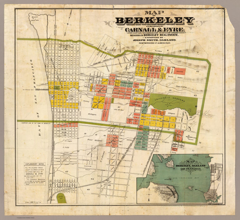
Author
Smith, Joseph, draftsman
Full Title
Map of Berkeley. Published by Carnall & Eyre, dealers in Berkeley Real Estate. Compiled by Joseph Smith, Oakland. From the records of Alameda Co., Cal. Lith. A. Waldstein, S.F. (1880)
Publisher
Carnall & Eyre
Author
Mitchell, Samuel Augustus
Full Title
(Covers to) Mitchell's new general atlas, containing maps of the various countries of the World, plans of cities, etc., embraced in ninety-three quarto maps. Forming a series of one hundred and forty-seven maps and plans. Together with valuable statistical tables. Also, a list of post-offices of the United States and territories, and census of 1860 and 1870. Philadelphia: Published by S. Augustus Mitchell, No. 815 Arch Street. 1880. Entered ... 1879, by S. Augustus Mitchell ... Washington.
Publisher
S.A. Mitchell
Author
Mitchell, Samuel Augustus
Full Title
(Title Page to) Mitchell's new general atlas, containing maps of the various countries of the World, plans of cities, etc., embraced in ninety-three quarto maps. Forming a series of one hundred and forty-seven maps and plans. Together with valuable statistical tables. Also, a list of post-offices of the United States and territories, and census of 1860 and 1870. Philadelphia: Published by S. Augustus Mitchell, No. 815 Arch Street. 1880. Entered ... 1879, by S. Augustus Mitchell ... Washington.
Publisher
S.A. Mitchell
Author
Mitchell, Samuel Augustus
Full Title
(Contents to) Mitchell's new general atlas, containing maps of the various countries of the World, plans of cities, etc., embraced in ninety-three quarto maps. Forming a series of one hundred and forty-seven maps and plans. Together with valuable statistical tables. Also, a list of post-offices of the United States and territories, and census of 1860 and 1870. Philadelphia: Published by S. Augustus Mitchell, No. 815 Arch Street. 1880. Entered ... 1879, by S. Augustus Mitchell ... Washington.
Publisher
S.A. Mitchell
Author
Mitchell, Samuel Augustus
Full Title
A time table indicating the difference in time between the principal cities of the World and also showing their air-line distance from Washington. Entered ... 1864 by S. Augustus Mitchell, Jr. ... Pennsylvania. (1880)
Publisher
S.A. Mitchell
Author
Mitchell, Samuel Augustus
Full Title
Western Hemisphere. Entered ... 1879 by S. Augustus Mitchell ... Washington. (1880)
Publisher
S.A. Mitchell
Author
Mitchell, Samuel Augustus
Full Title
Eastern Hemisphere. Entered ... 1879 by S. Augustus Mitchell ... Washington. (1880)
Publisher
S.A. Mitchell
Author
Mitchell, Samuel Augustus
Full Title
Map of the World on the Mercator projection, exhibiting the American Continent as its centre. Entered ... 1879 by S. Augustus Mitchell ... Washington. (1880)
Publisher
S.A. Mitchell
Author
[Mitchell, Samuel Augustus, Williams, W. (Wellington)]
Full Title
Map of North America. Showing its political divisions, and recent discoveries in the Polar Regions. Constructed and engraved by W. Williams, Philadelphia. Entered ... 1879 by S. Augustus Mitchell ... Washington. (1880)
Publisher
S.A. Mitchell
Author
Mitchell, Samuel Augustus
Full Title
County map of Nova Scotia, New Brunswick, Cape Breton Id. and Pr. Edward's Id. (with) City and harbor of Halifax. Entered ... 1879 by S. Augustus Mitchell ... Washington. (1880)
Publisher
S.A. Mitchell
Author
Mitchell, Samuel Augustus
Full Title
Map of Ontario in counties. Entered ... 1879 by S. Augustus Mitchell ... Washington. (1880)
Publisher
S.A. Mitchell
Author
Mitchell, Samuel Augustus
Full Title
Map of Quebec in counties. (with) Environs of Montreal. Entered ... 1879 by S. Augustus Mitchell ... Washington. (1880)
Publisher
S.A. Mitchell
Author
Mitchell, Samuel Augustus
Full Title
1776. Map of the original thirteen colonies. (with) Fac-simile of the first money coined by the United States. Copied from John Mitchell's Map of the British & French dominion. Entered ... 1879 by S. Augustus Mitchell ... Washington. (1880)
Publisher
S.A. Mitchell
Author
[Mitchell, Samuel Augustus, Williams, W. (Wellington)]
Full Title
Map of the United States and territories. Together with Canada &c. (with) Island of Newfoundland. Constructed & engraved by W. Williams, Philadelphia. Entered ... 1879 by S. Augustus Mitchell ... Washington. (1880)
Publisher
S.A. Mitchell
Author
Mitchell, Samuel Augustus
Full Title
County map of the state of Maine. (with) Portland Har. and vicinity. Entered ... 1879 by S. Augustus Mitchell ... Washington. (1880)
Publisher
S.A. Mitchell
Full Title
County and township map of the states of New Hampshire and Vermont. (By S. Augustus Mitchell, 1880)
Publisher
S.A. Mitchell
Author
Mitchell, Samuel Augustus
Full Title
County and township map of the states of Massachusetts, Connecticut and Rhode Island. Drawn and engraved by W.H. Gamble, Philadelphia. Entered ... 1879 by S. Augustus Mitchell ... Washington. (1880)
Publisher
S.A. Mitchell
Author
Mitchell, Samuel Augustus
Full Title
Plan of Boston. (with) Map of the country around Boston showing also its harbor and islands. Entered ... 1879 by S. Augustus Mitchell ... Washington. (1880)
Publisher
S.A. Mitchell
Author
Mitchell, Samuel Augustus
Full Title
County map of the state of New York. (with) Buffalo. (with) Rochester. (with) West Troy, Troy. (with) Albany. (with) Harbor and vicinity of New York. Drawn and engraved by W.H. Gamble, Philadelphia. Entered ... 1879 by S. Augustus Mitchell ... Washington. (1880)
Publisher
S.A. Mitchell
Author
Mitchell, Samuel Augustus
Full Title
New York and Brooklyn. Entered ... 1879 by S. Augustus Mitchell ... Washington. (1880)
Publisher
S.A. Mitchell
Author
Mitchell, Samuel Augustus
Full Title
County map of the state of Pennsylvania. (with) Harrisburg. (with) Williamsport. (with) Erie. (with) Scranton. Drawn and engraved by W.H. Gamble, Philadelphia. Entered ... 1879 by S. Augustus Mitchell ... Washington. (1880)
Publisher
S.A. Mitchell
Author
Mitchell, Samuel Augustus
Full Title
Plan of the city of Philadelphia and Camden. Drawn and engraved by W.H. Gamble, Philadelphia. Entered ... 1879 by S. Augustus Mitchell ... Washington. (1880)
Publisher
S.A. Mitchell
Author
Mitchell, Samuel Augustus
Full Title
County map of New Jersey. County map of Maryland and Delaware. Drawn and engraved by W.H. Gamble, Philadelphia. Entered ... 1879 by S. Augustus Mitchell ... Washington. (1880)
Publisher
S.A. Mitchell
Author
Mitchell, Samuel Augustus
Full Title
County map of Virginia and West Virginia. Drawn & engd. (by) W.H. Gamble, Phila. Entered ... 1879 by S. Augustus Mitchell ... Washington. (1880)
Publisher
S.A. Mitchell
Author
Mitchell, Samuel Augustus
Full Title
Plan of Baltimore. Entered ... 1879 by S. Augustus Mitchell ... Washington. (1880)
Publisher
S.A. Mitchell
Author
Mitchell, Samuel Augustus
Full Title
Plan of the city of Washington. The capitol of the United States of America. Drawn and engraved by W.H. Gamble. Entered ... 1879 by S. Augustus Mitchell ... Washington. (1880)
Publisher
S.A. Mitchell
Author
Mitchell, Samuel Augustus
Full Title
County map of Kentucky and Tennessee. Drawn and engraved by W.H. Gamble, Philadelphia. Entered ... 1879 by S. Augustus Mitchell ... Washington. (1880)
Publisher
S.A. Mitchell
Author
Mitchell, Samuel Augustus
Full Title
County map of the states of Georgia and Alabama. (with) Savannah, Georgia. (with) City of Atlanta, the capitol of Georgia. Entered ... 1879 by S. Augustus Mitchell ... Washington. (1880)
Publisher
S.A. Mitchell
Author
Mitchell, Samuel Augustus
Full Title
North and South Carolina. (with) Plan of Charleston. Entered ... 1879 by S. Augustus Mitchell ... Washington. (1880)
Publisher
S.A. Mitchell
Author
Mitchell, Samuel Augustus
Full Title
County map of Florida. (with) Mobile. Entered ... 1879 by S. Augustus Mitchell ... Washington. (1880)
Publisher
S.A. Mitchell
Author
Mitchell, Samuel Augustus
Full Title
County map of the states of Arkansas, Mississippi and Louisiana. Drawn and engraved by W.H. Gamble, Philadelphia. Entered ... 1879 by S. Augustus Mitchell ... Washington. (1880)
Publisher
S.A. Mitchell
Author
Mitchell, Samuel Augustus
Full Title
Plan of New Orleans. Entered ... 1879 by S. Augustus Mitchell ... Washington. (1880)
Publisher
S.A. Mitchell
Author
Mitchell, Samuel Augustus
Full Title
County map of the state of Texas. Showing also portions of the adjoining states and territories. Drawn and engraved by W.H. Gamble, Philadelphia. (with) Plan of Galveston and vicinity. Entered ... 1879 by S. Augustus Mitchell ... Washington. (1880)
Publisher
S.A. Mitchell
Author
Mitchell, Samuel Augustus
Full Title
County & township map of the states of Ohio and Indiana. Entered ... 1879 by S. Augustus Mitchell ... Washington. (1880)
Publisher
S.A. Mitchell
Author
Mitchell, Samuel Augustus
Full Title
Plan of Cincinnati and vicinity. Entered ... 1879 by S. Augustus Mitchell ... Washington. (1880)
Publisher
S.A. Mitchell
Author
Mitchell, Samuel Augustus
Full Title
County & township map of the state of Illinois. (with) Vicinity of Springfield. Entered ... 1879 by S. Augustus Mitchell ... Washington. (1880)
Publisher
S.A. Mitchell
Full Title
Chicago. (By S. Augustus Mitchell. 1880)
Publisher
S.A. Mitchell
Author
Mitchell, Samuel Augustus
Full Title
St. Louis. Entered ... 1879 by S. Augustus Mitchell ... Washington. (1880)
Publisher
S.A. Mitchell
Author
Mitchell, Samuel Augustus
Full Title
County & township map of the states of Iowa and Missouri. Drawn & engraved by W.H. Gamble, Philadelphia. Entered ... 1879 by S. Augustus Mitchell ... Washington. (1880)
Publisher
S.A. Mitchell
Author
Mitchell, Samuel Augustus
Full Title
Plan of Milwaukee. Entered ... 1879 by S. Augustus Mitchell ... Washington. (1880)
Publisher
S.A. Mitchell
Author
Mitchell, Samuel Augustus
Full Title
County and township map of the states of Michigan and Wisconsin. Drawn and engraved by W.H. Gamble, Philadelphia. Entered ... 1879 by S. Augustus Mitchell ... Washington. (1880)
Publisher
S.A. Mitchell
Author
Mitchell, Samuel Augustus
Full Title
Plan of Detroit. Entered ... 1879 by S. Augustus Mitchell ... Washington. (1880)
Publisher
S.A. Mitchell
Author
Mitchell, Samuel Augustus
Full Title
County map of Minnesota. Drawn and engraved by W.H. Gamble. Entered ... 1879 by S. Augustus Mitchell ... Washington. (1880)
Publisher
S.A. Mitchell
Author
Mitchell, Samuel Augustus
Full Title
Territory of Montana. Entered ... 1879 by S. Augustus Mitchell ... Washington. (1880)
Publisher
S.A. Mitchell
Author
Mitchell, Samuel Augustus
Full Title
County & township map of the states of Kansas and Nebraska. Drawn and engraved by W.H. Gamble, Philadelphia. Entered ... 1879 by S. Augustus Mitchell ... Washington. (1880)
Publisher
S.A. Mitchell
Full Title
Territory of Wyoming. (By S. Augustus Mitchell. 1880)
Publisher
S.A. Mitchell
Full Title
Territory of Dakota. (By S. Augustus Mitchell. 1880)
Publisher
S.A. Mitchell
|