Who What Where WhenREMOVEWHERE
WHOShow More |
REFINE
Browse All : Nautical charts of Maryland and Delaware Bay from 1862
1-41 of 41
Author
[Bruff, J. Goldsborough, Disturnell, John]
Full Title
(Covers to) Army Map Of The Seat Of War In Virginia, Showing the Battle Fields, Fortifications, Etc. on & near the Potomac River. Drawn by J.G. Bruff. Published by J. Disturnell, New York And Hudson Taylor, Washn. D.C. 1862. Entered ... 1861, by John Disturnell ... New York. Lith. of P.S. Duval & Son, Philada.
Publisher
[Disturnell, Taylor]
Author
[Bruff, J. Goldsborough, Disturnell, John]
Full Title
Army Map Of The Seat Of War In Virginia, Showing the Battle Fields, Fortifications, Etc. on & near the Potomac River. Drawn by J.G. Bruff. Published by J. Disturnell, New York And Hudson Taylor, Washn. D.C. 1862. Entered ... 1861, by John Disturnell ... New York. Lith. of P.S. Duval & Son, Philada.
Publisher
[Disturnell, Taylor]
Author
Bufford, J.H.
Full Title
Plan of the Naval Attack And Capture of Port Royal By the Federal Fleet under Com. S.F. Dupont - November 7th, 1861. To whom the above work is respectfully dedicated by an Officer of the U.S. Navy. Entered ... 1862 by J.H. Bufford ... Mass.
Publisher
J.H. Bufford's, Lith.
Author
Colton, J. H.
Full Title
(Covers to) Colton's New Railroad & County Map Of The United States, The Canadas &c. Published By J.H. Colton, No. 172 William St., New York 1862. Entered ... 1861 by J.H. Colton ... New York. (inset) Colton's Map of the United States Showing the Proposed Railroad Routes To The Pacific Ocean. (inset) Southern Part Of Florida.
Publisher
[J.H. Colton, Sampson Low, Son & Co.]
Author
Colton, J. H.
Full Title
Colton's New Railroad & County Map Of The United States, The Canadas &c. Published By J.H. Colton, No. 172 William St., New York 1862. Entered ... 1861 by J.H. Colton ... New York. (inset) Colton's Map of the United States Showing the Proposed Railroad Routes To The Pacific Ocean. (inset) Southern Part Of Florida.
Publisher
[J.H. Colton, Sampson Low, Son & Co.]
Author
Colton, J. H.
Full Title
(Covers to) Colton's Plans Of U.S. Harbors Showing The Position & Vicinities Of The Most Important Fortifications On The Sea-Board And In The Interior. From U.S. Surveys and other authentic sources. Published by J.H. Colton, 172 William St. New York. 1862. Entered ... 1860, by J.H. Colton ... New York. Printed by Lang & Laing 117 Fulton St. New York.
Publisher
[Bacon & Co., J.H. Colton]
Author
Colton, J. H.
Full Title
Colton's Plans Of U.S. Harbors Showing The Position & Vicinities Of The Most Important Fortifications On The Sea-Board And In The Interior. From U.S. Surveys and other authentic sources. Published by J.H. Colton, 172 William St. New York. 1862. Entered ... 1860, by J.H. Colton ... New York. Printed by Lang & Laing 117 Fulton St. New York.
Publisher
[Bacon & Co., J.H. Colton]
Author
Colton, J. H.
Full Title
(Covers to) Colton's New Topographical Map of The States Of Virginia, Maryland and Delaware, Showing Also Eastern Tennessee & Parts Of Other Adjoining States, All the Fortifications, Military Stations, Rail Roads, Common Roads and other Internal Improvements Compiled from the Latest & most Authentic Sources, On A Scale of 12 Miles to the Inch. Published By J.H. Colton, No. 172 William St. New York. Entered ... 1862, by J.H. Colton ... New York. Printed by Lang & Laing Lith 117 Fulton St. New York.
Publisher
J.H. Colton
Author
Colton, J. H.
Full Title
Colton's New Topographical Map of The States Of Virginia, Maryland and Delaware, Showing Also Eastern Tennessee & Parts Of Other Adjoining States, All the Fortifications, Military Stations, Rail Roads, Common Roads and other Internal Improvements Compiled from the Latest & most Authentic Sources, On A Scale of 12 Miles to the Inch. Published By J.H. Colton, No. 172 William St. New York. Entered ... 1862, by J.H. Colton ... New York. Printed by Lang & Laing Lith 117 Fulton St. New York.
Publisher
J.H. Colton
Author
Davies & Co.
Full Title
(Covers to) Map Of The Seat Of Civil War In America. October, 1862. Davies & Co. 1, Finch Lane, London. Maclure, Macdonald & Macgregor, 37, Walbrook, London, Lithographers by Steam Power. (inset) Enlarged Plan Of The Site Of The Most Recent Battles.
Publisher
Davies & Co.
Author
Davies & Co.
Full Title
Map Of The Seat Of Civil War In America. October, 1862. Davies & Co. 1, Finch Lane, London. Maclure, Macdonald & Macgregor, 37, Walbrook, London, Lithographers by Steam Power. (inset) Enlarged Plan Of The Site Of The Most Recent Battles.
Publisher
Davies & Co.
Author
[Stanford, Edward, W. & A.K. Johnston Limited]
Full Title
United States. (untitled inset map of Washington, D.C. and Northern Virginia).
Publisher
W. & A.K. Johnston
Author
Perrine, Charles O.
Full Title
(Covers to) Perrine's New Military Map Illustrating The Seat of War. Entered according to Act of Congress, in the year 1862, by C. O. Perrine, in the Clerk's Office of the District Court of the State of Indiana. (with) Inset map of Southern Part of Florida.
Publisher
Mumford & Co.
Author
Perrine, Charles O.
Full Title
Perrine's New Military Map Illustrating The Seat of War. Entered according to Act of Congress, in the year 1862, by C. O. Perrine, in the Clerk's Office of the District Court of the State of Indiana. (with) Inset map of Southern Part of Florida.
Publisher
Mumford & Co.
Author
U.S. War Department, Topographical Engineers
Full Title
"Surveys For Military Defences" Map Of N. Eastern Virginia And Vicinity Of Washington compiled in Topographical Engineers Office at Division Head Quarters Of General Irvin McDowell Arlington, January 1th 1862 corrected from recent Surveys and Reconnaissances under the direction of the Bureau Of Topographical Engineers August 1st 1862. Drawn By J.J. Young, W. Hesselbach. Engr. On Stone By J. Schedler, No. 120 Pearl St. N.Y. ...
Publisher
J. Schedler
Author
Anonymous
Full Title
(James River).
Publisher
No publisher
Author
U.S. War Department, Topographical Engineers
Full Title
Part of Washington County, MD. Bureau of Topographical Engineers September, 1862.
Publisher
Bureau of Topographical Engineers
Author
U.S. War Department, Topographical Engineers
Full Title
Sketch Of Country Between Haxall's Landing And Charles City Court House. Reconnoissances under the direction of Brig. Gen A.A. Humphreys, Comdg. Topl Engr's, by 1st Lieut. N. Bowen, Topl. Engrs., 2d Lieut. C. McClellan, 32d N.Y.. Vols., Mr. F.W. Dorr, Assist. U.S.C.S., Mr. Joseph McMakin, Drftsmn., Mr. H.H. Humpheys, Mr. Walter Taylor.
Publisher
Bureau of Topographical Engineers
Author
Colton, J. H.
Full Title
(Composite of) Colton's New Railroad & County Map Of The United States, The Canadas &c. Published By J.H. Colton, No. 172 William St., New York 1862. Entered ... 1861 by J.H. Colton ... New York. (inset) Colton's Map of the United States Showing the Proposed Railroad Routes To The Pacific Ocean. (inset) Southern Part Of Florida.
Publisher
[J.H. Colton, Sampson Low, Son & Co.]
Author
U.S. Coast Survey
Full Title
Part of Henrico County Virginia from Smith's Map in the collection of the U.S. Coast Survey Office. (Another title below) Part of Henrico County from Smith's Map of Virginia with additions of Topography from Surveys made under the direction of Genl A.A. Humphreys, Chief Topl Engr. Army of Potomac. Photographed at the U.S. Coast Survey Office July 1862. (title on verso) Map of Part of Henrico County Virga. ...
Publisher
U.S. Coast Survey
Author
U.S. Coast Survey
Full Title
(Title Page to) Part of Henrico County Virginia from Smith's Map in the collection of the U.S. Coast Survey Office. (Another title below) Part of Henrico County from Smith's Map of Virginia with additions of Topography from Surveys made under the direction of Genl A.A. Humphreys, Chief Topl Engr. Army of Potomac. Photographed at the U.S. Coast Survey Office July 1862. (title on verso) Map of Part of Henrico County Virga. ...
Publisher
U.S. Coast Survey
Author
Colton, J.H.
Full Title
(Covers to) J.H. Colton's Topographical Map of the Seat Of War In Virginia, Maryland, &c. J.H. Colton's Geographical Establishment No. 172 William St. New York. Entered ... 1862, by J.H. Colton ... New York. Printed By Lang & Cooper, 117 Fulton St. N.Y.
Publisher
J.H. Colton & Co.
Author
Colton, J.H.
Full Title
J.H. Colton's Topographical Map of the Seat Of War In Virginia, Maryland, &c. J.H. Colton's Geographical Establishment No. 172 William St. New York. Entered ... 1862, by J.H. Colton ... New York. Printed By Lang & Cooper, 117 Fulton St. N.Y.
Publisher
J.H. Colton & Co.
Author
Asher & Company
Full Title
(Covers to) The Historical War Map. Asher & Co. Entered ... 1862, by Asher & Co. ... Indiana. E.R. Jewett & Co. Engravers, Buffalo, N.Y.
Publisher
Asher & Company
Author
Asher & Company
Full Title
The Historical War Map. Asher & Co. Entered ... 1862, by Asher & Co. ... Indiana. E.R. Jewett & Co. Engravers, Buffalo, N.Y.
Publisher
Asher & Company
Author
Mallory, C.A.
Full Title
(Cover to) Part of the North Bank of the Rappahannock River showing the approaches to Fredericksburg, prepared under the direction of Capt. R.S. Williamson & 1st Lt. Nicholas Bowen ... for the use of the Army of the Potomac compiled by Fred. Churchill Vol. A.D.C. U.S. Coast Survey Chart of the Rappahannock River Surveys and Reconnoissances by C.A. Mallory, Chas. Shoemacker, L.C. Oswell, H.H. Marvin, Geo. F. Lathrop, Assistants. Drawn by C.A. Mallory. Reduced and photographed by L.E. Walker, Treasy. Dept.
Publisher
U.S. Treasury Dept.
Author
Mallory, C.A.
Full Title
Part of the North Bank of the Rappahannock River showing the approaches to Fredericksburg, prepared under the direction of Capt. R.S. Williamson & 1st Lt. Nicholas Bowen ... for the use of the Army of the Potomac compiled by Fred. Churchill Vol. A.D.C. U.S. Coast Survey Chart of the Rappahannock River Surveys and Reconnoissances by C.A. Mallory, Chas. Shoemacker, L.C. Oswell, H.H. Marvin, Geo. F. Lathrop, Assistants. Drawn by C.A. Mallory. Reduced and photographed by L.E. Walker, Treasy. Dept.
Publisher
U.S. Treasury Dept.
Author
Matz, Otto H.
Full Title
(Cover to) Map Of The Country Between Monterey, Tenn. & Corinth, Miss. showing The Lines Of Entrenchments Made & The Routes Followed by The U.S. Forces under the Command of Maj. Genl. Halleck, U.S. Army, In Their Advance Upon Corinth, In May 1862: Surveyed under the direction of Col Geo. Thom, A.D.C. & Chief Of Topl Engrs. Department Of The Mississippi, by Lieuts. Fred. Schraag and C.L. Spangenberg Asst. Topl. Engrs. and drawn by Lieut. Otto H. Matz Asst. Topl. Engr. Lith of J. Bien, 180 Broadway N.Y.
Publisher
J. Bien
Author
Matz, Otto H.
Full Title
Map Of The Country Between Monterey, Tenn. & Corinth, Miss. showing The Lines Of Entrenchments Made & The Routes Followed by The U.S. Forces under the Command of Maj. Genl. Halleck, U.S. Army, In Their Advance Upon Corinth, In May 1862: Surveyed under the direction of Col Geo. Thom, A.D.C. & Chief Of Topl Engrs. Department Of The Mississippi, by Lieuts. Fred. Schraag and C.L. Spangenberg Asst. Topl. Engrs. and drawn by Lieut. Otto H. Matz Asst. Topl. Engr. Lith of J. Bien, 180 Broadway N.Y.
Publisher
J. Bien
Author
Matz, Otto H.
Full Title
Map Of The Field Of Shiloh, Near Pittsburgh Landing, Tenn. Shewing The Position of the U.S. Forces under the Command Of Maj. Genl. U.S. Grant U.S. Vol. And Maj. Genl. D.C. Buell U.S. Vol. On The 6th And 7th of April 1862. Surveyed Under The Direction Of Col. Geo Thom. Chief of Topl. Engrs. Drawn by Otto H. Matz, Asst. Topl. Engr. Lith. by Chas. Robyn & Co. cor. Chestnut and 3d St, St. Louis Mo.
Publisher
Chas. Robyn & Co.
Author
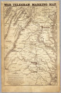
Prang, L. & Co.
Full Title
War Telegram Marking Map. L. Prang & Co. Print Publishers, 159, Washington St. Boston ... Entered ... 1862 by L. Prang & Co. ... Massachusetts.
Publisher
L. Prang
Author
Abbot, Henry L.
Full Title
Official Plan of The Siege Of Yorktown Va. Conducted by the Army of the Potomac under the command of Maj. Gen. George B. McClellan U.S.A. April 5th to May 3rd 1862. Prepared under the direction of Brig. Gen J.G. Barnard Chief Engr. by Lieut. Henry L. Abbot Top. Engrs. A.D.C. ... Lith. by J.F. Gedney, Washn. Chas. G. Krebs, Engr.
Publisher
J.F. Gedney
Author
Abbot, Henry L.
Full Title
Campaign Map, Army Of The Potomac. Map No. 3 White House To Harrisons Landing. Prepared By Command Of Maj. Gen. George B. McClellan, U.S.A. Commanding Army Of The Potomac Brig. Gen. A.A. Humphreys ... Compilation under the Direction of Brig. Gen. A.A. Humphreys, By Capt. H.L. Abbot, Top. Engrs. Engraved by W.H. Dougal.
Publisher
U.S.
Author
Abbot, Henry L.
Full Title
Campaign Map, Army Of The Potomac. Map No. 2 Williamsburg To White House. Prepared By Command Of Maj. Gen. George B. McClellan, U.S.A. Commanding Army Of The Potomac Brig. Gen. A.A. Humphreys ... Compilation under the Direction of Brig. Gen. A.A. Humphreys, By Capt. H.L. Abbot, Top. Engrs. Engraved by W.H. Dougal.
Publisher
U.S.
Author
Abbot, Henry L.
Full Title
Campaign Maps, Army Of The Potomac. Map No. 1 Yorktown To Williamsburg. Prepared By Command Of Maj. Gen. George B. McClellan U.S.A. Commanding Army Of The Potomac Brig. Gen. A.A. Humphreys ... Compilation under the Direction of Brig. Gen. A.A. Humphreys, By Capt. H.L. Abbot, Top. Engrs. Engraved by W.H. Dougal.
Publisher
U.S.
Author
[Asher & Company, Russell, Benjamin B.]
Full Title
(Covers to) The Historical War Map. Asher & Co. Entered ... 1862, by Asher & Co. ... Indiana. E.R. Jewett & Co. Engravers, Buffalo, N.Y.
Publisher
Benjamin B. Russell
Author
[Asher & Company, Russell, Benjamin B.]
Full Title
The Historical War Map. Asher & Co. Entered ... 1862, by Asher & Co. ... Indiana. E.R. Jewett & Co. Engravers, Buffalo, N.Y.
Publisher
Benjamin B. Russell
Author
Lloyd, J. T.
Full Title
(Covers to) Lloyd's official map of the State of Virginia from actual surveys by order of the Executive 1828 & 1859. Corrected and revised by J.T. Lloyd to 1862, from surveys made by Capt. W. Angelo Powell, of the U.S. Topographical Engineers of Gen. Rosencrans' Staff. Price 25cts. ... J.T. Lloyd, Publisher, 164 Broadway, New York ... Entered ... 1861 by J.T. Lloyd ... New York.
Publisher
J.T. Lloyd
Author
Lloyd, J. T.
Full Title
Lloyd's official map of the State of Virginia from actual surveys by order of the Executive 1828 & 1859. Corrected and revised by J.T. Lloyd to 1862, from surveys made by Capt. W. Angelo Powell, of the U.S. Topographical Engineers of Gen. Rosencrans' Staff. Price 25cts. ... J.T. Lloyd, Publisher, 164 Broadway, New York ... Entered ... 1861 by J.T. Lloyd ... New York.
Publisher
J.T. Lloyd
Author
Johnson, A.J.
Full Title
Johnson's Map of the Vicinity of Richmond, and Peninsular Campaign in Virginia. Showing also the Interesting Localities along the James, Chickahominy, and York Rivers. Compiled from the Official Maps of the War Department. By Johnson and Ward.
Publisher
Johnson and Ward
1-41 of 41
|