Who What Where WhenREMOVE |
Author
[Homann, Johann Baptist, 1663-1724, Hubner, Johann, 1688-1731]
Full Title
(Charte von Europa. Charte von Asia. Charte von Africa. Charte von America. Johanne Baptista Homanno, Norimbergae, 1719)
Publisher
Johann Baptist Homann.
Author
Fullarton, A. & Co.
Full Title
Africa by G.H. Swanston. Revised and Corrected, including Speke and Grant's researches as to The Sources Of The Nile. By J. Bartholomew, F.R.G.S. (with) four inset maps. LXXII. A. Fullarton & Co. Edinburgh, London & Dublin.
Publisher
A. Fullarton & Co.
Author
Burr, David H., 1803-1875
Full Title
Africa. Entered ... 1834 by Thomas Illman ... New York.
Publisher
D.S. Stone
Author
Reichard, C. G.
Full Title
Africa von C.G. Reichard. Nurnberg, bei Fr. Campe. (1822)
Publisher
Friedrich Campe.
Author
Reichard, C. G.
Full Title
Nord Africa von C.G. Reichard. Nurnberg, bei Friedrich Campe. 1819 (1822)
Publisher
Friedrich Campe.
Author
Berghaus, Hermann
Full Title
Afrika. (with) Pic von Tenerife. (with) Bu-Chail-Gebirge (Algerien). (with) Kamerun-Gebirge. (with) Gebirgslauf des Congo. (with) Atlas-Lander. (with) Capland. (with) Kilima-Ndsharo. (with) Oase Chargeh nach K. v. Zittel. (with) Abyssinien. (with) Amba-Landschaft (Abyssinien). (with view) Magdala von Ost nach Zeichnung v. Th. v. Heuglin. Entw. v. Herm. Berghaus 1887, Ausg. 1888. 7 Nebenkarten gez. v. M. Risch, gest. v. A. Reichenbecher & F. Kogel. Gotha: Justus Perthes (1892)
Publisher
Justus Perthes
Author
[National Geographic Society, Graves, William, Garver Jr., John]
Full Title
Africa.
Publisher
National Geographic Society
Author
Haack, Hermann
Full Title
Schulwandkart von Afrika.
Publisher
Justus Perthes
Author
[Brockhaus, F.A., Leeder, Ehrenfried, Leutemann, Heinrich]
Full Title
Afrika.
Publisher
F.A. Brockhaus
Author
Wyld, James, 1812-1887
Full Title
Africa. J.W. del. (engraved by) Stockley, Sc. London, James Wyld, Charing Cross. (to accompany) An Atlas of the World, Comprehending Separate Maps of its various Countries, Constructed & drawn from the latest Astronomical & Geographical Observations. By James Wyld, Geographer to Her Majesty and H. Late R.H. Prince Albert. London. Published by James Wyld (Successor to Mr. Faden) Charing Cross East. 1864.
Publisher
James Wyld
Author
Wyld, James, 1812-1887
Full Title
South Africa. By James Wyld. Published by Jas. Wyld Geographer to the Queen ... Charing Cross, East London. (inset) Port Natal. (to accompany) An Atlas of the World, Comprehending Separate Maps of its various Countries, Constructed & drawn from the latest Astronomical & Geographical Observations. By James Wyld, Geographer to Her Majesty and H. Late R.H. Prince Albert. London. Published by James Wyld (Successor to Mr. Faden) Charing Cross East. 1864.
Publisher
James Wyld
Author
Mitchell, Samuel Augustus Jr.
Full Title
Map Of Africa, Showing Its Most Recent Discoveries. (inset map) 84. Island of St. Helena. Constructed & Engraved by W. Williams. Philadelphia. . Entered ... 1860 by S. Augustus Mitchell, Jr. ... Pennsylvania.
Publisher
S.A. Mitchell Jr.
Author
Bellin, Jacques Nicolas, 1703-1772
Full Title
Plan de la Forteresse et Bourg, de l'Isle de Ste. Helene.
Publisher
J.N. Bellin
Author
Arrowsmith, Aaron Jr.
Full Title
Africa. London, Published Jany. 4.1825 by A. & S. Arrowsmith, No.10 Soho Square.
Publisher
A. & S. Arrowsmith
Author
Arrowsmith, Aaron Jr.
Full Title
Lower Egypt. London, Published Jany. 4.1825 by A. & S. Arrowsmith, No.10 Soho Square.
Publisher
A. & S. Arrowsmith
Author
Arrowsmith, Aaron Jr.
Full Title
Cape of Good Hope. London, Published Jany. 4.1825 by A. & S. Arrowsmith, No.10 Soho Square.
Publisher
A. & S. Arrowsmith
Author
Klett-Perthes
Full Title
Africa.
Publisher
Justus Perthes Verlag Gotha GmbH
Author
Wenschow - Franzis, Karl
Full Title
Africa, Wenschow Relief-Like Map.
Publisher
Rand McNally Co.
Author
Haack - Painke
Full Title
Africa.
Publisher
Justus Perthes/Klett Perthes
Author
Klett-Perthes
Full Title
Africa.
Publisher
Justus Perthes Verlag Gotha GmbH
Author
Klett-Perthes
Full Title
Africa.
Publisher
Justus Perthes Verlag Gotha GmbH
Author
Arrowsmith, Aaron
Full Title
Africa. To the Committee and Members of the British Association for Discovering the Interior Parts of Africa. This Map is with Their Permission most respectfully Inscribed, by their most obedient and humble Servant, A. Arrowsmith. A. Arrowsmith, London, Rathbone Place, November 1st, 1802.
Publisher
A. Arrowsmith
Author
Bellin, Jacques Nicolas, 1703-1772
Full Title
(Covers to) Le Petit Atlas Maritime Recueil De Cartes et Plans Des Quatre Parties Du Monde. Tome III. Contenant, I, L' Asie, II, L' Afrique. Avec les details interessans de ces Deux Parties. M, DCC, LXIV.
Publisher
J.N. Bellin
Author
Bellin, Jacques Nicolas, 1703-1772
Full Title
Carte de L'Afrique.
Publisher
J.N. Bellin
Author
Bellin, Jacques Nicolas, 1703-1772
Full Title
Rade et ville de Ceute .
Publisher
J.N. Bellin
Author
Bellin, Jacques Nicolas, 1703-1772
Full Title
Plan de la Ville de Mellila.
Publisher
J.N. Bellin
Author
Bellin, Jacques Nicolas, 1703-1772
Full Title
Plan d'Oran, et ses environs.
Publisher
J.N. Bellin
Author
Bellin, Jacques Nicolas, 1703-1772
Full Title
Plan du Chateau et Port de Marzalquivir.
Publisher
J.N. Bellin
Author
Bellin, Jacques Nicolas, 1703-1772
Full Title
Plan de la Ville Fort et Port d'Alger.
Publisher
J.N. Bellin
Author
Bellin, Jacques Nicolas, 1703-1772
Full Title
Plan de l'isle de Tabarque à la coste de Barbarie.
Publisher
J.N. Bellin
Author
Bellin, Jacques Nicolas, 1703-1772
Full Title
Plan de port Farine.
Publisher
J.N. Bellin
Author
Bellin, Jacques Nicolas, 1703-1772
Full Title
Golphe de Tunis.
Publisher
J.N. Bellin
Author
Bellin, Jacques Nicolas, 1703-1772
Full Title
Plan des Forts et Canal de la Goulette. (engraved by) Croisey.
Publisher
J.N. Bellin
Author
Bellin, Jacques Nicolas, 1703-1772
Full Title
Plan de la Rade et Ville de Tripoli à la Coste de Barbarie.
Publisher
J.N. Bellin
Author
Bellin, Jacques Nicolas, 1703-1772
Full Title
Costes D'Egypte Depuis Alexandrie Jusqu'À Rosette.
Publisher
J.N. Bellin
Author
Bellin, Jacques Nicolas, 1703-1772
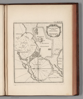
Full Title
Plan des Ports et Ville d'Alexandrie.
Publisher
J.N. Bellin
Author
Bellin, Jacques Nicolas, 1703-1772
Full Title
Carte Exacte Du Cours Du Nil.
Publisher
J.N. Bellin
Author
Bellin, Jacques Nicolas, 1703-1772
Full Title
Carte De L'Entree De La Riviere De Sanaga ou Senegal.
Publisher
J.N. Bellin
Author
Bellin, Jacques Nicolas, 1703-1772
Full Title
Costes d'Afrique depuia le Cap Verd jusquau Cap Verga. (engraved by) Croisey.
Publisher
J.N. Bellin
Author
Bellin, Jacques Nicolas, 1703-1772
Full Title
Plan de l'Isle de Gore avec ses Fortifications.
Publisher
J.N. Bellin
Author
Bellin, Jacques Nicolas, 1703-1772
Full Title
Carte des Isles du Cap Verd.
Publisher
J.N. Bellin
Author
Bellin, Jacques Nicolas, 1703-1772
Full Title
Carte De La Riviere De Gambra ou Gambie : depuis son Embouchure jusqua Eropina.
Publisher
J.N. Bellin
Author
Bellin, Jacques Nicolas, 1703-1772
Full Title
Carte De L'Entrée De La Riviere De Sierra Leona. (inset) Plan de l'Isle de Bense.
Publisher
J.N. Bellin
Author
Bellin, Jacques Nicolas, 1703-1772
Full Title
Entree De La Riviere De Sestos. (engraved by) Croisey. (inset) Vue du Cap Mesurado, et ses Environs.
Publisher
J.N. Bellin
Author
Bellin, Jacques Nicolas, 1703-1772
Full Title
Partie de la Coste de Guinee depuis la Riviere de Sierra Leona jusquau Cap das Palmas.
Publisher
J.N. Bellin
Author
Bellin, Jacques Nicolas, 1703-1772
Full Title
Carte de L'Isle de Madagascar et du Canal de Mozambique.
Publisher
J.N. Bellin
Author
Bellin, Jacques Nicolas, 1703-1772
Full Title
Carte de L'Ance Dauphine dans l'Isle de Madagascar.
Publisher
J.N. Bellin
Author
Bellin, Jacques Nicolas, 1703-1772
Full Title
Carte de la Baye d'Antongil dans l'Isle de Madagascar.
Publisher
J.N. Bellin
Author
Bellin, Jacques Nicolas, 1703-1772
Full Title
Carte de la Baye de Mosambique.
Publisher
J.N. Bellin
|