|
|
Author
[Covens et Mortier, Lisle, Guillaume de, 1675-1726]
Full Title
Hemisphere Occidental. Dresse en 1720 pour l'usage particulier du Roy sur les observations astronomiques et geographiques raportees la meme annee dans l'Histoire et dans les memoires de l'Academie Rle. des Sciences. Par Guillaume de l'Isle, premier Geographe de sa Majeste de la meme Academie. A Amsterdam, Chez J. Covens et C. Mortier. I. Condet sc.
Publisher
Covens & Mortier
Author
[Covens et Mortier, Lisle, Guillaume de, 1675-1726]
Full Title
Carte d'Amerique, dressee pour l'usage du Roy. Par Guillaume Delisle, premier Geographe de Sa Majeste de l'Academie Royale des Sciences. A Amsterdam, Chez Jean Covens et Corneille Mortier, Geographes. (Title in upper margin:) America accurate in imperia, regna, status & populos divisa, ad usum Ludovici LXV, Galliarum Regis. 1739.
Publisher
Covens & Mortier
Author
Lizars, Daniel
Full Title
Western Hemisphere. Published by D. Lizars, Edinburgh. (1831?)
Publisher
[John Hamilton, W. Curry, Jun. & Co., Whittaker, Treacher & Co.]
Author
Lizars, Daniel
Full Title
America. Published by D. Lizars, Edinburgh. (1831?)
Publisher
[John Hamilton, W. Curry, Jun. & Co., Whittaker, Treacher & Co.]
Full Title
South America. (Published by D. Lizars, Edinburgh. 1831?)
Publisher
[John Hamilton, W. Curry, Jun. & Co., Whittaker, Treacher & Co.]
Author
Lizars, Daniel
Full Title
(Composite of) America. Published by D. Lizars, Edinburgh. (1831?)
Publisher
[John Hamilton, W. Curry, Jun. & Co., Whittaker, Treacher & Co.]
Author
Robert Laurie & James Whittle
Full Title
(A new map of the whole continent of America, divided into north and south and West Indies. North half. Wherein are exactly described the United States of North America as well as the several European possessions according to the Preliminaries of Peace signed at Versailles Jan. 20, 1783. Compiled from Mr. d'Anville's maps of that continent, with the addition of the Spanish discoveries in 1775 to the north of California & corrected in the several parts belonging to Great Britain, from the original materials of Governor Pownall, MP. London, Publish'd by Laurie & Whittle, No. 53, Fleet Street, as the act directs 12th May, 1794)
Publisher
Laurie & Whittle
Author
[Anville, Jean Baptiste Bourguignon d, 1697-1782, Pownall, Thomas, Robert Laurie & James Whittle]
Full Title
A new map of the whole continent of America, divided into north and south and West Indies. (South half). (with) The supplement to North America containing the countries adjoining to Baffins & Hudsons bays. Wherein are exactly described the United States of North America as well as the several European possessions according to the Preliminaries of Peace signed at Versailles Jan. 20, 1783. Compiled from Mr. d'Anville's maps of that continent, with the addition of the Spanish discoveries in 1775 to the north of California & corrected in the several parts belonging to Great Britain, from the original materials of Governor Pownall, MP. London, Publish'd by Laurie & Whittle, No. 53, Fleet Street, as the act directs 12th May, 1794.
Publisher
Laurie & Whittle
Author
[Anville, Jean Baptiste Bourguignon d, 1697-1782, Pownall, Thomas, Robert Laurie & James Whittle]
Full Title
(Composite of) A new map of the whole continent of America, divided into north and south and West Indies. (South half). (with) The supplement to North America containing the countries adjoining to Baffins & Hudsons bays. Wherein are exactly described the United States of North America as well as the several European possessions according to the Preliminaries of Peace signed at Versailles Jan. 20, 1783. Compiled from Mr. d'Anville's maps of that continent, with the addition of the Spanish discoveries in 1775 to the north of California & corrected in the several parts belonging to Great Britain, from the original materials of Governor Pownall, MP. London, Publish'd by Laurie & Whittle, No. 53, Fleet Street, as the act directs 12th May, 1794.
Publisher
Laurie & Whittle
Author
[Ortelius, Abraham, Schoner, Johann]
Full Title
Maris Pacifici, quod vulgo Mar del Zur, cum regionibus circumiancentibus insulisque in eodem passim sparsis, novissima descriptio. From map of North America by Abrahamus Ortelius, 1589. Reduced. America from a globe in Frankfurt, about 1520. Reduced. Julius Bien, Photo-lith. U.S. Geographical Surveys West of the 100th Meridian. (1889)
Publisher
U.S.
Author
[Hondius, Jodocus, 1563-1612, Mercator, Gerhard, Mercator, Michael]
Full Title
America sive India Nova, ad magnae Gerardi Mercatoris aui Universalis imitationem in compendium redacta. Per Michaelem Mercatorem Duysburgensem. From "Hondius" Ed. 1609 Amst. Reduced. U.S. Geographical Surveys West of the 100th Meridian. (1889)
Publisher
U.S.
Full Title
Western Hemisphere. Copyright 1887 by Wm. M. Bradley & Bro. (1890)
Publisher
John Y. Huber & Co.
Author
Sayer, Robert
Full Title
A new map of the whole continent of America. (Southern section). Divided into north and south and West Indies, wherein are exactly described the United States of North America as well as the several European possessions according to the Preliminaries of Peace signed at Versailles Jan. 20, 1783. Compiled from Mr. d'Anville's maps of that continent, with the addition of the Spanish discoveries in 1775 to the north of California & corrected in the several parts belonging to Great Britain from the original materials of Governor Pownall, MP. London, printed for Robt. Sayer, Map, Chart & Printseller, no. 53, Fleet Street, as the Act directs 15th August, 1786.
Publisher
Robert Sayer
Author
Sayer, Robert
Full Title
(Composite of) A new map of the whole continent of America. Divided into north and south and West Indies, wherein are exactly described the United States of North America as well as the several European possessions according to the Preliminaries of Peace signed at Versailles Jan. 20, 1783. Compiled from Mr. d'Anville's maps of that continent, with the addition of the Spanish discoveries in 1775 to the north of California & corrected in the several parts belonging to Great Britain from the original materials of Governor Pownall, MP. London, printed for Robt. Sayer, Map, Chart & Printseller, no. 53, Fleet Street, as the Act directs 15th August, 1786.
Publisher
Robert Sayer
Author
Clouet, J. B. L. (Jean-Baptiste Louis), b. 1730
Full Title
Lacs, fleuves, rivieres et principales montagnes de l'Amerique. Introduction. (1787)
Publisher
Mondhare et Jean
Author
Clouet, J. B. L. (Jean-Baptiste Louis), b. 1730
Full Title
Isles, caps et ports de mer de l'Amerique. Introduction. (1787)
Publisher
Mondhare et Jean
Author
Clouet, J. B. L. (Jean-Baptiste Louis), b. 1730
Full Title
De l'Amerique en general. (1787)
Publisher
Mondhare et Jean
Author
Mitchell, Samuel Augustus
Full Title
Western Hemisphere. Entered ... 1879 by S. Augustus Mitchell ... Washington. (1880)
Publisher
S.A. Mitchell
Full Title
(L'Amerique. A Lyon, Chez Jean-Marie Bruyset, Pere & Fils. M.DCC.LXXXIV)
Publisher
Jean-Marie Bruyset
Author
Fer, Nicolas de
Full Title
L'Amerique, Meridionale et Septentrionale. Dressee selon les dernieres relations et suivant les nouvelles decouvertes dont les points principaux sont placez sur les observations de Mrs. de l'Academie Royale des Sciences. Par N. de Fer. A Paris, Chez l'Auteur dans l'Isle du Palais sur le Quay de l'Orloge a la Sphere Royale. Avec priv. du Roy. 1717. C. Inselin scripsit.
Publisher
Danet
Author
Stieler, Adolf
Full Title
Polynesien Und Der Grosse Ocean Im Maassstabe von 1:40.000.000. (Ostliches Blatt) Von A. Petermann. Gezeichnet v. E. Debes. Gest v. C. Stier. Gotha: Justus Perthes 1872.
Publisher
Justus Perthes
Author
[Geographisches Institut (Weimar, Germany), Kiepert, Heinrich, 1818-1899]
Full Title
America. Bearbeitet und gezeichnet von H. Kiepert. Gestochen v. C. Jungmann. Weimar, Verlag des Geographischen Instituts, 1856.
Publisher
Weimar Geo Inst.
Author
Stieler, Adolf
Full Title
America : entworfen von C.G. Reichard 1816. Rrevidi(e)rt und new gestochen 1823. Anm. deb nördlichsten Teil enthalt die Polar - Karte No. 41b. (on upper right margin) Stielers Hand Atlas No. 41. (to accompany) Hand-Atlas uber alle Theile der Erde, nach dem neuesten Zustande und uber das Weltgebaude.
Publisher
Justus Perthes
Author
Stieler, Adolf
Full Title
America : entworfen von C.G. Reichard 1816. L. Hess sct. (on upper right margin) Hand Atl.No. 41. (to accompany) Hand-Atlas uber alle Theile der Erde, nach dem neuesten Zustande und uber das Weltgebaude. (insets) Nordwestspitze von America ; Sudspitze von America.
Publisher
Justus Perthes
Author
[Anville, Jean Baptiste Bourguignon d, 1697-1782, Faden, William, 1750?-1836]
Full Title
A map of America or the New World, wherein are introduced all the known parts of the Western Hemisphere, from the map of D'Anville; with the necessary alterations, and the addition of the discoveries made since the year 1761. London: published by W. Faden, Geographer to the King and to H.R.H. the Prince of Wales, Charing-Cross, April 12th, 1797. Wm. Palmer sculp.
Publisher
William Faden
Author
Bowen, Emanuel
Full Title
A new general map of America. Drawn from several accurate particular maps and charts, and regulated by astronomical observations. By Eman. Bowen. (London: Printed for William Innys, Richard Ware, Aaron Ward, J. and P. Knapton, John Clarke, T. Longman and T. Shewell, Thomas Osborne, Henry Whitridge ... M.DCC.XLVII)
Publisher
William Innys [et al.]
Author
Standard Oil
Full Title
Pictorial Map of the Americas featuring the Pan American Highway.
Publisher
Standard Oil
Author
[Alcedo, Antonio de, 1735-1812, Arrowsmith, Aaron, Thompson, George Alexander]
Full Title
(Covers to) Atlas to Thompson's Alcedo; or dictionary of America & West Indies; collated with all the most recent authorities, and composed chiefly from scarce and original documents, for that work, by A. Arrowsmith, Hydrographer to His Royal Highness the Prince Regent. London: Printed by George Smeeton, Great Saint Martin's Lane, Charing Cross. 1819.
Publisher
George Smeeton
Author
[Alcedo, Antonio de, 1735-1812, Arrowsmith, Aaron, Thompson, George Alexander]
Full Title
(Index to) Atlas to Thompson's Alcedo; or dictionary of America & West Indies; collated with all the most recent authorities, and composed chiefly from scarce and original documents, for that work, by A. Arrowsmith, Hydrographer to His Royal Highness the Prince Regent. London: Printed by George Smeeton, Great Saint Martin's Lane, Charing Cross. 1819.
Publisher
George Smeeton
Author
[Alcedo, Antonio de, 1735-1812, Arrowsmith, Aaron, Thompson, George Alexander]
Full Title
(Title Page to) Atlas to Thompson's Alcedo; or dictionary of America & West Indies; collated with all the most recent authorities, and composed chiefly from scarce and original documents, for that work, by A. Arrowsmith, Hydrographer to His Royal Highness the Prince Regent. London: Printed by George Smeeton, Great Saint Martin's Lane, Charing Cross. 1819.
Publisher
George Smeeton
Author
Dussieux, L.
Full Title
Cartes pour Servir a l'Histoire de l'Amerique et des Colonies jusqu'en 1765. 150. Carte du'ne Partie de l'Amerique du Nord avant la paix de Breda (1667). 151. Carte pour servir a l'histoire de l'Amerique et des Colonies depuis kes traites d'Utrecht (1713) jusqu'aux traites de Paris (1763). 152. Carte de l'Amerique du Nord d'apres le traite de Paris en 1763.
Publisher
Jacques Lecoffre et Comp.
Author
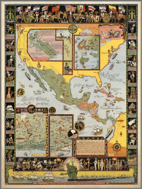
Mora, Jo (1876-1947)
Full Title
Ye Olde Spanish Main. Designed and executed by Jo Mora. Copyrighted 1933 by Grace Line.
Publisher
Grace Line Company
Author
Codazzi, Agustin, 1793-1859
Full Title
America historica, fisica y politica actual. 1840. Gravee par Muschani. Imprimee chez Thierry freres a Paris. (Caracas 1840)
Publisher
[Agostino Codazzi, Thierry Freres.]
Author
Janvier, Jean
Full Title
L'Amerique divisee par grand etats. Par le Sr. Janvier Geographe. A Paris, Chez Lattre Graveur, rue St. Jacques, pres la Fontaine Saint Severin, a la Ville de Bordeaux. Avec privilege du Roy. 1783.
Publisher
Lattre & Delalain
Author
Martin de Moussy, V. (Victor), 1810-1869
Full Title
Carte de l'Empire Espagnol dans les deux Ameriques en 1776 a l'epoque de la fondation de la Vice Royaute de la Plata. Par le Dr. V. Martin de Moussy 1867. Grave par L. Kautz, r. Bonaparte 82 Paris. Paris Imp. Lemercier, r. de Seine 57. (Paris Librairie de Firmin Didot Freres, Fils et Cie., 1873)
Publisher
Firmin Didot Freres.
Author
Society for the Diffusion of Useful Knowledge (Great Britain)
Full Title
(World on gnomonic projection. II. America). No.2. Published by Baldwin & Cradock, 47 Paternoster Row June 1831. Under the superintendence of the Society for the Diffusion of Useful Knowledge. Engraved by J. & C. Walker.
Publisher
Chapman and Hall
Author
Finley, Anthony
Full Title
(Covers to) American Atlas (Pocket Atlas).
Publisher
Anthony Finley
Author
Finley, Anthony
Full Title
(Front Lining to) American Atlas (Pocket Atlas). Index.
Publisher
Anthony Finley
Author
Finley, Anthony
Full Title
Text Page: (Back Lining: (Table)) Population of Principal Cities and Towns.
Publisher
Anthony Finley
Author
Mitchell, Samuel Augustus Jr.
Full Title
Western Hemisphere. Copyright by S. Augustus Mitchell 1884.
Publisher
Wm. M. Bradley & Bro.
Author
Sayer, Robert
Full Title
(A new map of the whole continent of America. Northern section. Divided into north and south and West Indies, wherein are exactly described the United States of North America as well as the several European possessions according to the Preliminaries of Peace signed at Versailles Jan. 20, 1783. Compiled from Mr. d'Anville's maps of that continent, with the addition of the Spanish discoveries in 1775 to the north of California & corrected in the several parts belonging to Great Britain from the original materials of Governor Pownall, MP. London, printed for Robt. Sayer, Map, Chart & Printseller, no. 53, Fleet Street, as the Act directs 15th August, 1786)
Publisher
Robert Sayer
Author
Johnston, Alexander Keith, 1804-1871
Full Title
The River Systems of America showing the Boundaries and Comparative Extent of the River basins, and the Seas to which they Contribute their Waters.
Publisher
William Blackwood & Sons
Author
Johnston, Alexander Keith, 1804-1871
Full Title
The River Systems of America showing the Boundaries and Comparative Extent of the River basins, and the Seas to which they Contribute their Waters. (continued)
Publisher
William Blackwood & Sons
Full Title
Western Hemisphere. Copyright 1886 by Wm. M. Bradley & Bro.
Publisher
Wm. M. Bradley & Bro.
Author
Moll, Herman, d. 1732
Full Title
America. By H. Moll Geographer. (Printed and sold by T. Bowles next ye Chapter House in St. Pauls Church yard, & I. Bowles at ye Black Horse in Cornhill, 1736?)
Publisher
Thos. Bowles and John Bowles
Author
Vandermaelen, Philippe, 1795-1869
Full Title
(Composite of) Amer. Sep. no. 1 - 76 and Amer. Merid. no. 1 - 43. (Dresse par Ph. Vandermaelen, lithographie par H. Ode. 1827)
Publisher
Ph. Vandermaelen
|